

jmundinger
-
Posts
386 -
Joined
-
Last visited
Everything posted by jmundinger
-
If you have a card reader, you might try erasing and/or reformatting the card and/or transferring the maps to the card using the reader. Then, see if you can restart the unit with the card in place.
-
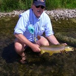
It's a pretty minor inconvenience, really. And, it's easy enough to work the buttons with the rubber band in place. Here is a picture of my Legend C. I did put Scotch tape under the gasket but, by the time I got around to it, I was used to the rubber band and decided to put it back on.
-
A good basic unit, with more than all of the features that you need would be either the Garmin Venture HC or the Garmin Summit HC. Anything more than that would be for features that are not essential to caching. You could also consider the Garmin eTrex H. But, the cable is an extra and it will only work with a computer that has a serial port or if you also purchase an adapter and, by the time you pay for the unit, the cable and the adapter, you will have spend about the same as you would for the Venture HC and that unit comes with a USB cable. Based on my own experience, I would stick with something in the Garmin line. I have been very satisfied with the units that I have purchased and satisfied with their commitment to customer service.
-
There are at least two work arounds. You can hold it in place with a wide rubber band (the kind that grocers use on broccoli work pretty well). You can also reattach the band by cleaning off the old glue and using double sided Scotch tape.
-
An imaginery conversation with Garmin
jmundinger replied to gallet's topic in GPS technology and devices
While that might be true, I think my other observation is still correct - you are beta testing a unit that perhaps should not yet be on the market. I also think it is correct to assume that, while the person who wrote the program might not know the limit and, even if she/he does, you aren't talking to that person. Moreover, the person with whom you are talking might not know how to get the information, either. -
First, you need to create a file of waypoints in either .csv or .gpx format. That latter is probably easier to do. You can use MapSource to generate a list of waypoints and then use the "save as" function to save the list - when you do, change the format to .gpx, rather than the default Garmin database format. You could also use EasyGPS, ExpertGPS or GSAK. Then, note where you saved that file and go to it when you get to that screen. After you have loaded them, the points of interest with show up as "custom poi" on the find page.
-
An imaginery conversation with Garmin
jmundinger replied to gallet's topic in GPS technology and devices
I seriously doubt that Garmin is deliberately trying to annoy people. I do think that we - the casual users of commercial grade gps units - have high expectations for performance, utility and price. Based only on the posts on this board, I would draw several conclusions. 1. Sometimes our expectations are unrealistic, given the technology v. price limitations of the units that we own. 2. Sometimes our expectations exceed the published capability of the units that we have purchased. 3. Sometimes our complaints are legitimate and, when they are, Garmin apparently is more responsive than other manufacturers in trying to deal with those issues. That said, some support personnel at Garmin are more knowledgeable and more helpful than others. 4. Garmin brought the Colorado to market too soon (and probably did the same thing with the H series) - responding too quickly to our expectations for greater performance and features while still expecting to purchase the equipment for a discount. -
An imaginery conversation with Garmin
jmundinger replied to gallet's topic in GPS technology and devices
I just checked. MapSource displays both the number of maps and the total size. -
My take on the Garmin Vista HCX
jmundinger replied to highrolla7's topic in GPS technology and devices
Without a little better definition of your issue, I'm not sure I can tell you how to deal with it. My first suggestion (not specific to the map issue) is to go to the Garmin website and download the user's manual for one of the earlier models (I used the one for the Vista C - you have to look in the discontinued section). The earlier user's manuals are more complete that the one that came with your unit. -
An imaginery conversation with Garmin
jmundinger replied to gallet's topic in GPS technology and devices
I am not familiar with Mapinstall. However, I do use Mapsource. Mapsource doesn't count the number of selected map segments - but it does generate a list. More importantly, Mapsource keeps a record of the size of the file set (note that all map segments are not the same size). And, if you know the size of the file that you are trying to transfer and you know the size of the card to which you intend to send the file, you should have a pretty good idea whether the map set will fit. If Mapinstall doesn't have that feature, I can understand your frustration. Either way, I still think you need to be counting bytes, not segments. -
An imaginery conversation with Garmin
jmundinger replied to gallet's topic in GPS technology and devices
If you don't like the product and don't like the customer service, why not return the merchandise and purchase something else from someone else who offers a better product and better service. Please advise us of the result when you discover who that company and product might be. -
missing pointer on garmin 60 csx
jmundinger replied to RandolfPringles's topic in GPS technology and devices
Sounds to me like your compass page reset to "course pointer". Scroll through the pages until you get to the compass page. Select the menu for that page and select the "bearing pointer" and you should get it back. -
Need Garmin eTrex Venture HC info--
jmundinger replied to busternfruss's topic in GPS technology and devices
As another posted mentioned, you don't need the maps for caching. We have several hiking trails in the Helena area and many caches are hidden throughout the trail system. I have used Topo as an aid (a supplement to the trail map) in hiking to some of those caches, but not for actually finding the caches. I also have used Topo (as well as USAPhotoMaps) to help plan some of the caches that I have hidden - but I did that on the computer desktop, not on the gpsr. But, I didn't use Topo in selecting the hiding spot. MapSource, which comes with the Venture HC, is a very basic map that can also be used to transfer data back and forth with the gpsr. However, if you also have GoogleEarth installed on your computer, MapSource will interface with it, i.e. you can plot a location/track in MapSource and view it in GoogleEarth. -
If the person hiding the cache and the person hunting the cache use their gpsr's correctly, I think the differences between the model used by the hider and the model used by the hunter has little to do with with dnf. We are playing with commercial grade equipment. Even under ideal conditions, there is a probable error associated with every data point recorded by every gpsr. And,when conditions are less than perfect (which would be the usual situation) additional and unpredictable error is introduced. And, as a foot note, if you want to compare the "accuracy" of two units, hunt up a benchmark or other fixed location. A comparison of "accuracy" based on proximity to a geocache is meaningless because the location of the geocache is just the best guess of the hider, without any indication of the confidence interval around that guess.
-
Getting tracks back onto computer?
jmundinger replied to buzzman63's topic in GPS technology and devices
I presume that your Legend Hcx came with a copy of MapSource. You can download the track by connecting the gpsr to your computer and using that program. MapSource has a send/receive function for transferring waypoints, tracks and routes back and forth between your computer and the gpsr. MapSource also has a routine that will allow you to view what is displayed in MapSource in GoogleEarth (assuming that GoogleEarth is installed on your computer). -
Need Garmin eTrex Venture HC info--
jmundinger replied to busternfruss's topic in GPS technology and devices
Based on the description of your needs, I think the Venture HC would be an excellent choice. I have a Legend C, which, based on the description, is just a discontinued version of the Venture HC, without the high sensitivity receiver. I still use it a lot, even though I have since purchased a Vista HCx. -
Using GPS to mark a line in the woods
jmundinger replied to PastorJon's topic in GPS technology and devices
If you want to do it with a handheld gpsr, you might consider purchasing one of these: http://www.igage.com/thales/ -
AllTopo (www.igage.com) speaks Garmin. However, I have reported a bug to them regarding an error that occurs when waypoints are transferred from the program to the gps. They transfer correctly going from the gpsr to the maps and, if you then transfer those waypoints back to a gps there doesn't seem to be a problem. But, if you manually enter waypoints on the map, those might be off. You also might check out USAPhotoMaps - a piece of shareware available from jdmcox.com
-
76CSx vs 60CSx vs Vista HCx
jmundinger replied to Eaglecacher55's topic in GPS technology and devices
If cost is a factor, I think he should also add the SummitHC to his list for consideration. For the application that he described, it sounds like 24 mb of internal memory would probably be sufficient and he might be able to forgo the cost differential between the Summit and the Vista and also avoid the additional cost for a memory card. -
I have a Vista HCx, but I presume the procedure is similar. Go to "SetUp" and from that page select "Heading". On that page you should have the option to display the heading in cardinal letters (I think that is the default setting), in degrees or in mils.
-
Easy GPS is a good tool for managing waypoints. If you want to see what your waypoints look like on topo maps or satellite imagery, you might try USAPhotoMaps from jdmcox.com.
-
Help needed re: Garmin etrex H (please help!)
jmundinger replied to cnh624's topic in GPS technology and devices
If I were doing it, I think the first thing I would do would be to turn on the gpsr. Use the "quit" key to scroll through the pages until you get to the "main menu". On that page, use the up/down keys to scroll through that page to "waypoints" and press the enter key to select the waypoint page. Then use the up/down keys to scroll through the alphabetical listing of groups of waypoints and the enter key to select the portion of the alphabet that you are looking for. Then, use the up/down keys to scroll through the resulting group of waypoints, the enter key to select a specific waypoint; the up/down keys to navigate among the different functions and use the enter key to select "goto". Then press the quit key a few times to back out of the main menu and cycle among the main pages until you get to the "Pointer Page". With an active "goto", the Pointer Page will display direction and distance to the waypoint - the direction is determined relative to your location and based on your direction of travel - assuming that the gpsr is level. -
Garmin barometric altimeters - the evidence!
jmundinger replied to julianh's topic in GPS technology and devices
You're welcome. Correct. The picture has to be hosted someplace that this site can access - which you tell it to do with the html and the url to the site. In the case of your graph, all I did was right click on the image, copied the image location and then pasted that between the ] and the [ in the image html. By the way, thanks for sharing your analysis. -
Garmin barometric altimeters - the evidence!
jmundinger replied to julianh's topic in GPS technology and devices
Are you sure about that? In order to post an image, it first has to be hosted some place, like imagecave, photobucket etc. or on your ISP's server. Download the image from your gpsr to your computer - if it's a garmin, you can use the ximage utility, downloaded from from Garmin's website. Then upload the image to a hosting site and then copy the link to the image into your post. For it to work, you also have to use the appropriate have use html. For posting, that would be one set of brackets, [], with the letters img typed between that set of brackets. Then, paste the link to the image. Then type a second set of brackets, [], with the letters /img typed between that set. You can see what it looks like by hitting the reply button to my post.