

Ecylram
-
Posts
1523 -
Joined
-
Last visited
Posts posted by Ecylram
-
-
This didn't sound right to me so I downloaded a pocket query of the 167 caches and compare with what was said in the original post. As it turns out, it takes a lot of time to go through each cache with a careful eye.
Due to time constraints I stopped at 30 caches (selected alphabetically) and of those 30 caches:
- 15 involved a bomb Squad
- Two were in a parking lot
- Two were on the edge of a parking lot
- One was near school
- One had an unknown location
- One was by a cemetery
- Two were near a school
- One was at the side of a road
- Five were in parks or other green areas
- A couple of caches listed above as being in parking lots but only had parking lot close by
Based on a careful examination of this subset I'd say the overarching reason for caches appearing on that list is "Permission issues" (non-public areas where permission was not obtained).
-
The court minutes are not particularly well written, but it appears that the case went to the jury, beginning full deliberations yesterday morning around 8:30 am. The verdict was returned around 4 pm, finding Mr Heim guilty of the charged offense (assault with firearm) and special allegations (enhancements).
The court will have a number of sentencing options. Ffrom what I remember he could face up to 25 years -- although I would be surprised if he received the upper terms. A hearing will be held later after the probation department issues a report with its recommendations.
------------
It seems to have been a careful jury, asking three questions during their deliberations. They were out a fairly long time for this kind of case. I have seen capital cases with far shorter deliberations. But I don't think there were any winners here since the events were unfortunate for all concerned.
Thanks for the updated information. Based on the public court records the defendend, who is 71, turned down a plea bargain of 10 years and chose to go to trial. The defendent has been in jail since the incident as he was unable to make the $150,000 bail.
-
Have the geocachers been charged for trespassing?
I don't see why they would be charged. Based on reports...the area is unmarked, the cachers did not know it was private property and they immediately retreated when confronted. You generally don't see charges under those circumstances.
Pulled from a website discussing California tresspassing law:
"Specific intent" is a particular mental state. When you act with specific intent, it means that you not only intend your act, but that you also specifically intend the consequences of your act.10Example: While you hiking in the hills, you stop to rest. Despite the fact that there are no signs, no home, and no people, you are actually on someone else's private property. Given these facts, you aren't willfully entering another person's land or intending to interfere with any property rights.
-
So I guess the log (by the victim's uncle) on the original cache stating it was on "PUBLIC land" (their caps) is wrong.
Earlier I posted the link to the county zoning map - comparing that to the google map on the cache page quickly shows that both John Wayne caches are on private property. That has nothing to do with Mr. Heim's legal responsibility. Nobody could have foreseen his reaction, of course, and ultimately whatever guilt he bears can be sorted out by the court. But the incident need not have happened. I know that it is sometimes hard to determine boundaries in the field, so I hope that this will encourage us all to double check property information if we are not absolutely sure.
In any event, the rough position of the original John Wayne cache is around the blue dot on incorporated private property. The new cache is in the white (private unincorporated land) to the right, above the BLM land (striped). The replacement cache is dedicated to the teen who was shot. Perhaps the owner can move it to BLM property.
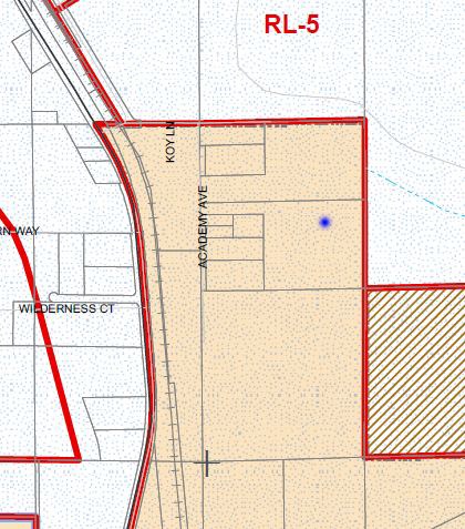
I did the same thing and I got a similar result, just slight smidge south of your dot. (I was using Fern Way as a guide.)
EDITED TO ADD: I had not checked the location of the new cache when I posted this. I just checked it and I also concur that the new cache is located on private unincorporated land.
-
Just wondering.
Discuss!
I vote for Scarlett Johansson as nude cacher of the month.
(ed.: Does she cache? me: I don't care.)

-
Only really being active at this for about 2 years now I'm just starting to see something I'm sure everyone else is used to. It seems that whenever there is a big local event, I start seeing caches I've found being archived off. Then, for the event, a new one is placed about 10' away so that cachers will have the fun of going after a new cache. I'm sure I understand the reasoning behind this; including drawing folks to the event, reducing saturation etc.
It would seem though that it goes against the idea of caches being permanent. I like finding new caches and I like going to events but it's a little big of a drag to see huge groups of caches go away just so they are fresh for an event a few months later.
I was even looking at a state park several hours away where an event is scheduled next year and they've even posted on the cache pages a date when they will be archiving off all of the caches.
I know the CO owns them and can do what they want and that we all play this game in a different way but I just wondered what everyone's thoughts were.
I believe I know which caches you are referring to. I had a chance to be the CO a few months ago and we talked about this.
As I recall, the CO (a family really) puts on this event every year where many people come from quite a distance. Old caches are archived and new caches are placed out. It's my understanding that the hides ARE different from year to year. Based on their description of the event, it sounded like a whole lot of fun.
-
I don't see how my geocaching life would be better if those tiny icons were removed. I hardly notice them and they are helpful for some.
But then I don't alphabetized my cereal boxes, or arainge them by height.
-
There is no "best" geocache. Geocaching is actually a collection of several cache hunting games, each with it's own favorites.
The outdoorsy hiking types will favor the beautiful vistas. The creative types will favor the unusual and original. The speed cachers will prefer the quick and easy caches. The puzzle cachers will favor those that provide a good mental challenge. The FTF fanatics will prefer close caches.
Since we aren't all playing the same game, there can't be any consensus on the 'one' best cache.
-
right, reading fail on my part
now out of curiosity based on what information does GSAK break them down into counties?
The coordinates.GSAK accesses the polygon information for the counties.
-
However, I don't think a pocket query will search by county.
of course it does "Countries" as well as "States / Provinces", one at the time though
It's easy to confuse "Counties" and "Countries" since they are only one character apart.
This is doable in GSAK. They have a free macro you download/run called "CountryStateCounty" and it will add the county information to each record. You can then filter by county and age to find your caches. It's really pretty easy.
-
Coords are off...
With accurate coordinates you'll almost never see "Coords are off" messages. By "Almost Never" I mean no such messages or only one in every few hundred logs.
For comparison, here are real world examples:
1. Coordinates are ~50 feet off for an LPC. About one in 10 logs point this out.
2. Coordinates are ~250 feet off for FC hidden under a statue. About 90% of the find logs mentioned the coordinates were off.
3. Coordinates are -30 feet off for a FC in a tree and point to a different tree. About one in 15 logs mentioned this easy hide was either missing (it wasn't) or had the wrong coordinates.
4. Had a nearby cache placed by a cacher notorious for having bad coordinates, but the coordinates were spot on. I made the find and logged it. A couple of weeks later, the CO emailed me to find out where it was located. Apparently someone had moved the cache to the correct coordinates and didn't tell the CO. Distance was about 35-40 feet.
There are two cachers in our area which are known to have bad coordinates. One uses a Nuvi to place the hides. The other..I have no idea why as they use a Garmin. Most are spot on, but about 1/3 are 20-35 feet off.
As for using Satellite images...In my area, the Google imagery is dead on accurate for 95+% of the metro area and they may have cleaned up the other little bit in the last year. HOWEVER...I've been to a spot in a VERY rural area and the imagery was 50-100 feet off. So...just be aware. Using imagery isn't a perfect solution, but it's great for catching transposed numbers in coordinates. :-) I figure if I've got a good reading AND it matches the imagery I'm in good shape. If the Imagery shows something different I go back and remeasure with the GPSr.
-
Here are my suggestions for improving the Challenges experience within the existing guidelines...
1. List the creators name under the Challenge title, not just logs. This makes it easier for the cacher to identify new Challenges they might like to do.
2. Allow full editing for 24-hours, even if the challenge has been accepted. It's often the first challenge accepter that notices an error in the description.
3. Allow the Challenge creator to APPEND information to the description after the 24-hour edit period. This allows for minor changes when there are changes at the Challenge location. For example might be: "Park now closes at 9pm, instead of 10pm."
4. Implement the Challenge phrase feature as quickly as possible. Right now the only way to verify the action was done is with a picture. This has created a "sameness" to the Challenges with little distinction between "Action" caches and "Photo" caches. Being able to input a piece of information gleemed from the location will open up more challenging challenges along with a greater variety.
5. Add the ability to expand the search area a bit further than the current default radius.
6. Add the option when flagging a challenge to select "Locationless" and "Not Verifiable" as reasons for flagging.
7. Add the option when flagging a "Completed the Challenge" entry to select "Not verified" (or similar appropriate wording).
8. Mapping - Being able to visually see where challenges are located would be helpful in planning Challenge trips.
9. PQ's - It would be usefull to easily add the challenges to our GPSr's.
10. Add the ability to add photos in the challenge description.
11. Watchlists - It will allow creators to easily follow what is going on and for others to be notified of interesting photos and logs.
I am not including on this list a change to the voting system as I believe its too early to draw a conclusion on what, if any, changes should be made.
-
As a veteran of this topic...
Blue Spruce are the worst of the tree hides in our area.
As for WHY people place these? Because it is easy and it wouldn't be an issue if there were only a few of these but in some areas that is the predominate hide. I know of one cacher in our area who has at least 200 of these spruce/fir/pine hides within a few square miles. It's an area of town that many cachers tell me they avoid for that reason.
-
Hello all,
I recently attempted to download the cache details of what looks like a great cach only to find it was premium members only.
When I emailed the owner I got the reply "...because I needed permission to place it" and "...it stops thieves".
Ok...the stealing part I can maybe understand if the container was special or contained something shinier than normal, but the permission part????? Why should that make a difference? The cache concerned is on a public footpath, for heavens sake!
Premium members have absolutely no problems seeking out basic member caches and logging them but REALLY don't like us non-premium members having access to thiers. Not everyone can afford the money to pay for membership and the arguement "...it only costs £0.whatever a day" is frankly insulting. If a two-tier eliteist system is going to exist then why does the site promote a community atmosphere when so many are excluded from some of the caches?
Please understand that not ALL premium members are so snobby, most are enlightened enough to know we are all playing the same game!
I don't need premium membership as pocket queries etc are pretty much useless to me and I can d/l and find caches quite easily thank you and the other benefits, again, are not for me.
All I want is an equal playing field for EVERYONE. Lets rid ourselves of premium only caches and if you want to pay for the other stuff...then do so!!
I know the flamers will have a field day with this (all premium members probably!!) but I AM entitled to voice my opinion...even if it doesn't coincide with yours!!
Magic Phil.
It's got nothing to do with snobbery and the sooner you let go of that opinion, the quicker you'll understand why people choose to make some caches Premium-only.
-
It's actually a four tier system. Basic, Premium, Platinum and...err...forget I mentioned 'four'. Ok?
-
That's "many reasons" to vote Down, and one reason to vote Up. The trend would be expected to be mostly Down votes.
27 out of the 30 nearest challenges to me have positive Thumbs ratios.
-
We had one person that was quickly thumbing down new challenges but they got bored after a couple of days.
Your challenge looks fine to me. It's similar to some I've done and don't have several negative votes.
Around here several negative votes tends to indicate some problem such a the challenge being locationless.
-
It's working for me as well from multiple browsers and devices. Have you checked your computer for malware lately?
-
Hmmm. NA was posted on 7/26/11. Reviewer disabled the cache on 7/29/11 and gave the CO time to respond. Seems totally normal to me.
In our area, a NA may lead to Reviewer disabling the cache if the situation warrants. They then give the CO at least a month to resolve before Archiving. They do a good job.
I see nothing alarming about how the reviewer is handling this situation.
-
I just foresee a confrontation some day and the owner will be more mad next time and will say, well, I talked to a geocacher already and he said he would make sure no one goes past the small foot bridge.
If the cache is within a swamp but likely folks will go to the clearing which is the more obvious GZ to us, the fact that its probably just outside his property does not seem like future geocachers will not cross his property line.
If it's not on his property than it shouldn't be reported.
-
Here is another issue..
Repetition..
I bet you there are going to be 100's of these:
Don't see any evidence of that but doesn't sound like a bad thing. "Gosh darn, there they go cleaning up the place again!"
-
If the cache is on his property and the property owner doesn't want it there, then it should be archived. Simple as that.
If the cache is on the property of the fellow who said he didn't want it on there, then email the reviewer with the details. It's important that we be respectful of property owner's requests.
-
Ironically, it is not very challenging, by the traditional definition of the word, to take a picture.
...
Traditional Geocaching... go to published coordinates, open box, sign log, go home and spend 3 seconds entering "TFTC" on the cache page.
Action Challenge Caching... go to published coordinates, perform a specfic task and take a picture, go home, download/crop/resize photo, and enter a log describing what task you performed at the location and upload your photo.
Photo Challenge Caching... go to published coordinates, take a specific picture of something at the location, go home, download/crop/resize photo, enter log describing your experience and upload your photo.
....
As I understand the arugments:
- Virtuals should count, even those without a verification process.
- Webcams should count.
- LPC's should count.
- 1/1 traditionals should count.
- A six-mile hike shouldn't count because it's called a challenge.
-
BTW, you can recreate it without the previous one being archived.
Teen Geocacher shot in leg for tresspassing?
in General geocaching topics
Posted
He has not been sentenced yet.