


MissJenn
-
Posts
4115 -
Joined
-
Last visited
Posts posted by MissJenn
-
-
Thanks so much, Ranger Tina!
-
RE: the archivals of some caches
I had shared with the City of Duluth that geocachers hide caches once they have the landowners' or land managers' permission to hide the cache.
The information they had at the time was this, from the guidelines:
You assure us that you have the landowner's and/or land manager's permission before you hide any geocache, whether placed on private or public property. Even if you are certain that geocaching is permitted on particular public property, ensure that you have followed any and all requirements established by the land owner or land management agency before placing the cache. There may be locations in which cache hides are inappropriate, even though not prohibited by local laws.
The City of Duluth fully supports this GeoTour and they wanted to place their own caches on the properties that they manage. Some of the locations which they felt worthy of highlighting had already been selected by earlier geocachers, but those appeared to have been hidden without proper permission. Geocaching HQ and the City are under the impression that permission from the City had not been granted for these caches. If you have additional info, please contact me directly with specific GC codes and we'll see about the best course of action.
Happy geocaching!
-
-
For those who use Twitter, Geocaching announces new GeoTours there as well.
https://twitter.com/GoGeocaching
And this hashtag will yield many geocaching-related hits, as well as other mentions of the word GeoTour.
#geotour:
-
Yes, what Rock Chalk said. It is a really good idea, ichthy9.
Until we get a digital reward figured out, Hosts and geocachers do have the option of producing a physical geocoin.
On a related note:
Did you know that the HQ GeoTour's reward geocoin is actually a stamp? The back of the coin was purposely minted in reverse. When ink is applied to it, you can use the coin to make an imprint of the design. You can see that imprint in the passport at the top of this photo. (I edited away the Tracking Code for this photo.)

-
Path Pacer, i absolutely agree with you. That *would* be very nice indeed.
-
Yay! Good luck!!
planning a return trip to finish -
Ha ha. Will do.
Thank you so much, gpsfun!

-
Cross-posted from today's Release Notes:
See which geocaches belong to a GeoTour with the new geocache search. You can click through via the yellow box from the search results to learn more about the GeoTour.
Try it for yourself! https://www.geocaching.com/play/search
In the example below, I used GC4HD1M in the Search box.
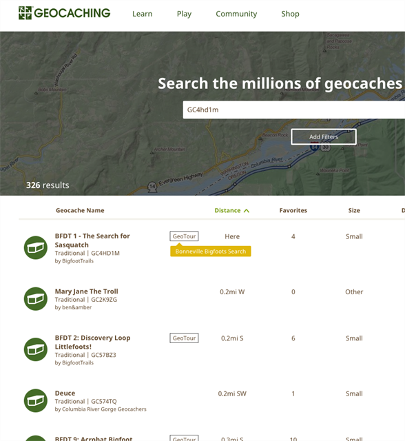
See the original Release Notes.
-
LOL

I'm not one of the judges, so no need to sway your design in that direction. (although an airborne MINI Cooper would be pretty fun...)

-
It IS exciting.
For those of you who do not know about LordBritish: His real name is Richard Garriott de Cayeux. He is a video game designer (Ultima, etc.), collector and private astronaut.
Oh AND quite a geocacher hider! Check out the Fave Points on his hides.
-
Calling all geocache makers, space enthusiasts, and museum lovers!
I call your attention to an upcoming event: #FlightCache Design Challenge at Museum of Flight, GC53WRC. Yes, it'll be a really cool event (on May 16, 2015). Yes, a famous person or two will be in attendance. Yes, your local friends will likely be in attendance as well. Yes, you should go.

What I want to point out here is this:
Your Participation is Needed Before April 19
There is an invitation open right now for YOU to design a creative aerospace-themed design for the Museum's next hide. They can help build it and make your dream a reality. They'll cover $200 in parts. You get credit for a truly astonishing geocache design.
The deadline is April 19. Bring your "A" game. Design a cache that will earn many, many Favorite Points once created.
You need not be present at the event to win BUT you do need to submit your ideas. Before April 19.

-
-
This older thread in the Northeast section of the US forums has some additional chatter that interested parties may find helpful.
-
Also, speaking of downloading the Tours, I believe most of the GeoTour GPX files are version 1.0. These means that I need to refresh the cache in GSAK to get the attributes, and other 1.01 features. I would like to see all GeoTour GPX files upgraded to 1.01.
We are working to make GeoTours more easily discoverable by the general public *and* easier to use both on your GPS and smartphone.
GPX files in v 1.0 are compatible with a wider range of devices which is why we chose that option.
-
-
As for the GeoCoins, they are unique. They are made my local artisans. The coins for the McKenzie River and Florence editions are a pair of interlocking jig saw pieces, that form an outline of Lane County.
This is what they look like:

-
Hello ByronForestPreserve.
Thanks for emailing us privately. For others: geotours@geocaching.com
We find that each person has very specific questions based on their specific project. It is actually more effective to answer questions in an email or a phone call, as opposed to answering all questions all ways on one webpage and making the GeoTour introduction page super long. :-)
a question about scope,...How large and significant an area do I need for my collection of caches to be considered for an official GeoTour?We leave this up to the GeoTour Host. What we do specify is the number of geocaches: between 5 and 150.
And to palmetto: You rock! That is all.

-
By the way, have you ever used the very special Download this GeoTour feature found at the top of each GeoTour page?
It's essentially a Pocket Query that is available to all geocachers, both Basic and Premium.
The little "pop up tip" explains:
You can download all the caches in this GeoTour and save it directly to your GPS device.Most newer devices allow you to copy the file directly to the internal memory of your
GPS device using a cable provided by the manufacturer. If you are having trouble consult
the manual for your device or seek assistance from the community discussion forum.

-
Skye,
THANK YOU SO MUCH! I appreciate your suggestions. More suggestions are certainly welcome from you and others.
- As a potential solution, know that the GeoTours in our global directory are currently displayed in that list based on date published. The ones at the top are newer than the ones at the bottom. Not what you asked for, I know. Still helpful, hopefully.
- Also we are so very thankful for that list of GC Codes you sent to Katie - caches that were missing the attribute. If you check back, you'll see that they have been adjusted. Well, mostly. There is a bug currently whereby we cannot assign that attribute to EarthCaches, which is obviously a problem since all cache types are fair game to be included in a GeoTour.
- I encourage you to start a new thread in this forum section - call it the Eugene Cascades and Coast GeoTour - that talks about your Lane County, Oregon experience. Many people would benefit from it. I would certainly appreciate it.
-
Thank you so much for the great response, Sus Antigoon!
cache-minions, would it be OK with you if I move this thread to a recently-created section specifically for GeoTours & Reward Geotrails?
-
-
Joshism,
jholly has quoted my text posted to the cache pages you pointed out. That is in red above.
Also, please note that the Kennedy Space Center GeoTour is one of the official GeoTours and not a geotrail.
Thanks for answering the question, jholly.
-
Also, something interesting is happening here. What is it?


VisitUtah Life Elevated Geocaching GeoTour
in GeoTours & reward geotrails
Posted
And here's the GeoTour page for your reference:
https://www.geocaching.com/play/geotours/visit-utah
Plus more at
http://www.visitutah.com/things-to-do/outdoor-adventures/geocaching