


Ratsneve
-
Posts
397 -
Joined
-
Last visited
Posts posted by Ratsneve
-
-
You'll have to post if the Garmin Oregon is actually an improvement, or even a solution, to the problems experienced with the Colorado. I would be interested in hearing your take...especially since you have firsthand experience with the Colorado and it's associated problems.
I will for certain. I know there will be a brief learning curve giving up the R-n-R for a touchscreen but g-o-cashers gives me good reason to feel that the Oregon is a few notches up on the Colorado. We'll see.
-
I actually think the issue of child waypoint management is a much bigger pain.
GO$Rs
What is child waypoint management and why is it a bigger pain? I think it is a pain that recent finds and the main odometer cannot be deleted or reset too.
g-o-cahers... Will you be working the new Delorme PN-40 when it comes out in October or do you stick solely with Garmin?
Thanks.
-
This has happened to me several times on one of my older 400t's. Check out the procedure given on the g-o-cachers WIKI: M12.) My Colorado seems to be corrupted, is there a way I can recover it?
http://garmincolorado.wikispaces.com/Miscellaneous
It worked fine for me.
This would have been a nice try but it looks like luck has favored me for the moment--maybe. Garmin has agreed (at least for the moment) to a one-time upgrade to the Oregon for my now defective Colorado. I agreed to a small $40 cost difference and they agreed to email me a pre-paid shipping label. But wait...did I actually get the pre-paid label--no. So tomorrow morning I have to call them up again to find out what happened again.
Part of me would normally have loved to try to fix the dadgum thing but its to late in the game for that--I'm to tired of Garmin.
-
I think it is a big deal, ignoring switchbacks.
Different strokes for different folks!

As Grasscatcher pointed out, there's no perfect solution. The art of finding what works best for you is to weigh the pros and cons and make the best informed choice you can.
I just think we are dismissing the "why" this is way to soon but you guys should know.
On another note I turned off shading and visited Snow Lake and Smith Rock. It makes only a little difference on the Colorado screen. I would much rather turn it back on.
But while searching for Mineral King looking for Franklin Pass the Colorado switched off deciding it had had enough of me. Trying to turn it on again results in "System Software Missing" and a weird state is entered into until a cell is removed. This is not good.
I think I'm finished with this thread and the Colorado and the PN-40 for a while now. Time to visit Mineral King and ride up into the Sierra's again without any GPS. -
I was using the 400t base map moving through Kings Canyon and the California Central Valley to the west when the screen went dead--I'm actually located in Central Oregon. I was using USB power at the time. Upon restarting the GPS I got the (I've heard of it before believe it or not) "System Software Missing" on the Garmin startup screen. The unit then goes into weird mode where it can't even be shut off. I've removed the batteries several times. I've tried entering diagnostics. I've even tried Reset. I've even tried a second set of charged cells--NOTHING but "System Software Missing" each time I try a fresh start. Since I can't get past this startup page there is nothing more I can do that I am aware of. While I do my half-hour wait for Garmin to answer I thought I would post this. It is funny because I have been actively working other problems that the Colorado has--and now this.
-
It makes me suspect that much of the trail data was drawn in on the T7 maps, and should be regarded as approximate. Functionally it works for me; I just expect there to be a trail somewhere in the vicinity. More accurate is better, but since I regard the GPS as a navigation aid that I don't rely upon completely (e.g., I always bring paper maps for any extended hiking or in territory I don't know well), it doesn't cause me problems.
One way that it *can* cause problems is if people use it for trail routes...the oversimplified route can lead to an unrealistically optimistic arrival time that doesn't take into account that there's a longer distance to cover than the more or less straight line indicates (take a look at this example). This is usually a matter of experience; I know to add time to what the PN-20 shows, but someone new and overly trusting of the instrument might make a bad decision (kinda like that guy who turned onto the railroad track because the GPS told him to.)
If it's important to you, you can make corrections in the form of addtions to your own maps similar to what I illustrated above. You cannot "erase" existing mistakes in the trail layer. You *can* submit corrections to Delorme for updates to their database, but that can take a year or two or three to get back to you in the form of a correction.
Bottom line for me is that it's less than ideal, but I don't see it as any big deal. I may be guilty of rationalization in this judgment.
I think it is a big deal, ignoring switchbacks. Especially if your a map company priding yourself in providing accurate maps. So someone at Delorme decided it would be quicker to draw a trail from a topo by averaging it? Very disappointing. Are there any other examples? How about Franklin Pass (long long time ago) out of Mineral King I think? Does it show averaged or show all its switchbacks. I think the difference would be much more then 20%. I could take a look at the Colorado 400t's base topo map.
-
After working in similar industries over the years I'm not surprised. Typically these folks are the last to know about these kinds of efforts and rest assured they aren't trolling the web looking for problems. The trick is to find the right people and many times the response can be positive, thanks go to Team Chinook for finding an open door!
GO$Rs
I'll take the more sinister skeptical approach and suggest that at some level in Garmin they know exactly what was wrong with these units from day one when beta testing gave up and the stuff was kicked out the door. I think Garmin knows how to blow smoke around like no other...
Tell me, did your executive contacts mention that there is a new software update in the works due out in a month or so that directly addresses and fixes the barometric pressue tracking when the unit is turned off and the drifting and accuracy issues?
Good luck everyone. This is what, month eight? They should be starting to wrap up some of the Colorado troubles soon. Meanwhile there are a number of Oregon owners that are really happy with there units.
I know this hasn't been helpful but it beats praying.
-
Because Garmin has been quiet to my phone and email attempts with a couple people last week I called again today. Nothing new why Garmin Wouldn't respond as I laid out my concerns. The person I need too talk to left for the day. The tech today did finally share that there is a new software update in the works that will be out in a month or so and that it will address the barometric pressure while turned off and the location marker drifting problems of the Colorado.
Garmin is going to be as stubborn as they legally can be concerning handing out refunds for the Colorado and the two maps I bought. This was my first request--that I return the CO and maps and they refund my money. The tech said it was highly unlikely this would happen. I did not elaborate further on that since he cannot make the decision anyway--the guy who does left for the day and he is the one who already has not reponded by email or phone calls. Should know by the end of this week though--or I start all over agian.
I suggested that even if the update fixed all the CO problems it was now highly unlikely I would keep the unit for other reasons. I suggested selling it on ebay and asked what path the new owner takes to transfer the registration and unlock codes to him. This is all doable and at no charge which was fine by me.
So, are your fingers all cramped up from keeping them crossed for so long?
-
BTW, I'm sorry this isn't exactly relative to the Challenge here but I am the op and you are all PN-20 folk. One issue I've had with the Colorado and it is true for the Oregon too is that some data cannot be cleared or reset directly from the GPSr. Geocaches once found and finished with cannot be deleted from the GPSr. On the Oregon you can reset the trip mileage but there is no way to reset the total odometer mileage. Some of these things can be deleted/removed by hooking up to the PC and deleting certain files directly. I think this is cumbersome and the wrong approach.
How does the PN-20 deal with these issues? I hope wherever data is taken or created there is a means from the PN-20/40 to reset or clear or delete them?
Also, is there any way by chance to lock a waypoint you create so that if one had created 50 waypoints but had 6 you wanted to keep you could lock those 6 and delete the others globally? Otherwise, like now on the Colorado, in order to keep a few waypoints one must delete all the others individually--takes time.
Thanks.
-
While theirs a lot of trail detail, the thin white line is very faint. Is it possible to turn off the DEM shading? These are awfully dark. Contours are very hard to see. How do you find map reading in the field?
Both the Garmin and Above the Timber maps show the trail going through the obvious saddle, whereas the T7 map has the trail 200' above the saddle. The T7 maps also appears to misname the wilderness.
Of note, because of the many more and smaller pixels of the CO, when pixel mapped to the PC screen, the CO screen appears much larger than in real life.
I'm pretty sure I can turn off the shading and will work on that today for Snow Lake and Smith Rock and another state park nearby that has trails. Wish I had left a waypoint marker at Snow Lake.
Don't know what to make of the apparent T7 trail location error.
>>>>>Knowing for example that a trail was mislocated on the T7 map, can it be corrected on an overlay that then shows the correct trail routing? _And_ can this correction then be left on one's T7 as a permanent change or must one forever juggle overlays? Surely there is danger doing this as T7 will one day be revised and you would lose your corrections? Oh well...for all I know there are better tricks already for tracking this sort of thing?
^^^^^
I suppose the larger screens offer this minor advantage? I've found only one local source so far for the PN-20 and they needed to charge up the battery in the unit which was dead. I'll go by again for a hands-on look and feel of an active screen though the salespeople there are clearly more partial to Garmin then Delorme.
-
Well, I do not have the Western Topo Data on my laptop right now so I went to the Oregon State web page to download some free aerial imagery (cir 2005), just a small aera. I then put this into XMap 5.2 ($99 for PN-xx owners and well worth the extra $). I'll try and get the regular Topo data later unless (ehhmm..Max, Slim) someone else beats me to it

Also, as stated above, until you actually see it first hand, you really shouldn't pass judgment yet These look really good, IMHO, but even better while you are actually looking at it in your hand - same goes for the Topo Data.
Could you (one) take embra's trail overlay and size it up and add it on top of this photo so the trails would more easily show up...especially for the shaded areas? Could the shaded areas be lightened up so they wouldn't look so contrasty?
-
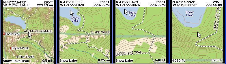
Here are my results for Snow Lake and Smith Rock. Note that I could not find Snow Lake by the normal search--I tried several different ways/categories with no luck... So I navigated brute force thanks to the I-90 shot and instructions included--thanks. During the navigation it took a long time--sometimes over a minute to draw to the new location. It also isn't real easy using the Rock-n-Roller on the Colorado as a joystick--to much pressue down and you click the 'enter' function of this multi-control. The actual screen size of the Colorado is 1.5" (close enough) wide x 2.5" high and its 240 x 400 pixels. It is a backlit color TFT. All the shots used Garmin's Topo U.S. 24 K - Northwest MicroSD. The pointer moved over a map feature describes that feature for ~ 5 seconds then the name disappears. Did I mention you have to be patient sometimes moving the pointer around? I think this challenge and maybe some other recent threads are instrumental in my acceptance that size isn't as important as content and design.
Here are Snow Lake shots. Note the trails. Trails may be the nicest part of these 24K topos? Note that Smith Rock has trails too but for some reason they don't show up in the 24K topo--I was disappointed to see this; and Topo7 didn't have trails either...but look how 'embra' solved that! Amazing. Smith Rock trails have been around a long time but maybe the topo sources are even older?


And here are Smith Rock shots. Benjamin921's photo shots were noteworthy of the PN-20 too.


Now let's see what these look like? I wonder how I can get these laid out better on the page...3 across and 4 across with a little gap between. If someone posted the code example I'll give it another edit try. Thanks. Ha! I figured it out.
What do you think of Garmin's 24K topos? I think I want a PN-40 for numerous reasons. But, regardless, I won't be the first to buy one--I must have learned something from this experience--maybe not.
The only thing remaining I think would be if a Garmin mapping pro would come along and add trails to Smith Rock or use photos with trails deliniated batter for the Colorado/Oregon use but so far those GPSr's have shown no interest in this challenge.
-
I do know the answer.
The PN-20 and PN-40 are bundled with the Topo7 software. Other imagery is extra; XMap Professional is available to PN owners at half-price ($99).So if you buy the PN-40 you'd be pretty much set for topo off road stuff which currently does not auto-route but might one day soon with a software update. For city driving and auto-routing one would buy Street Atlas U.S.A.?
Okay, I just got back from the website link. It looks like Topo7 does it all. Dadgum [  ], this is pretty much clinching it for me. When you see my Snow Lake and Smith Rock shots there isn't much to write home about except the larger screen. I'm bailing out of Garmin one way or the other and waiting for the PN-40 to gel--I may not bail for 3 months--whatever it takes.
 -
The lower left-hand corner is showing the object the cursor is pointing to; in the left-most shot it's the trail, in the right-most it's an elevation, and the middle ones are the lake.
When the cursor is showing current position, the topo display runs all the way to the top of the screen. If the cursor is moved, then the coords, bearing, and distance from position is show. Oregon is a couple thousand miles from where I am.
BTW, just how easy is it to navigate that pointer around the PN-20 screen? You may or may not know that the pointer on the Colorado isn't so much fun to move around--Garmin should redesign it so there isn't so much tendancy to push down (click) and almost ruin the whole affair.
-
As a point of information, I sold my Colorado 300 about a week after I purchased the Oregon 300. The Oregon is certainly not perfect, but it is way better than the Colorado.
You're not the first to say "way better". Is this based on performance (receiver behavior, accuracy, etc.) or because it has the touchscreen and easier alphanumeric entry?
Maybe REI and Wal*Mart are dumping the Colorado because they are sick and tired and lost money returning so many units? That doesn't mean Garmin, a huge GPS manufacturer, would come out with a GPS (Colorado) and cease to care for it six months later does it--that would be very pathetic? And surely if it comes to pass that Garmin does dump it there will be a good fair exchange to the Oregon or your money back...else 'you know what' will likely happen next. However, I also think in light of the poor technical support knowledge (support doesn't know what engineering does and still doesn't acknowled some of the oldest known problems, like the barometric pressure trending when the unit is turned off) there are some serious internal problems going on. This might also explain why these units were kicked on the market prematurely--unless everyone is really so satisfied to pay Garmin and beta test the products for free?
-
The Oregon is a GREAT unit. I think many people here are focusing too strongly on a few negatives which aren't really major issues when you are actually using the thing. It's great, i love it.
Okay, so what are the negatives of the Oregon now--anyone?
What are the negatives of the Colorado now? (You can't use 'not a touchscreen' as a negative.) :)I know, it's the Oregon wiki...oh well. How about limiting it to receivers, chipsets, antennas, drifting, WA, accuracy (clear and in mountainous forest on cloudy day).
I just disconnected my Colorado from 5 V leaving unit on under battery, moved unit 25 feet southeast, returned to exact same spot, plugged into external power again and noticed the location marker was 25 feet off to the east. It seemed stable there after not moving for five minutes or so. I turned the unit off and on and the location marker was back in its "correct" location where I've been averaging waypoints for over 24 hours now. Was this Drift? Was 25 feet excessive? Does the Oregon never experience this? With the Oregon, when you attempt "manual waypoint averaging" by manually setting waypoints over a prolonged period of time, what cluster diameter do you basically end up with for the Oregon? For my Colorado I end up with around a 20 foot diameter core.
I've used the Cororado successfully too for auto-routing and geocaching and I basically like it. But I still think Garmin did a poor job beta testing it and should not have released it when they did--and likewise from what I've read the Oregon too. That doesn't mean things may not be better now by a magnitude from when these units were released. It just means their release was premature and Garmin wittingly set us up to finish beta testing them for them at our cost. You can argue that that is the way it is now with technology and I can still argue that it is dirty business as far as I'm concerned. The Colorado should be as good a GPS as the Oregon if not a couple notches better by now since it has been out longer--it isn't and that's dirty dirty dirty!
Maybe g-o-cashers needs to get a replacement Oregon and go over all his points on the Oregon and finish up a good review of the GPS if you all think the beta testing was so good and that the remaining problems are so minor?
And maybe he should do likewise with the Colorado? I'm just dying to see the Colorado go from 2 to a 4 out of 5 rating--but not holding my breath.
-
Your behind in your reading, see here, must have been out playing all day.Um... What is the map source for your PN-20 shots? And I notice that the top picture says mapsource in the lower left but this isn't at all related to Garmin's MapSource is it. Remember you are dealing with a newbie who bought a Colorado and hasn't learned what she can really do with it yet--if anything....but I'll post Colorado shots soon all the same.
No...well...probably. But if I can make it confusing for me I will make it so.
-
experiment, I don't ever post images till (maybe) now. -----------

Norm
Um... What is the map source for your PN-20 shots? And I notice that the top picture says mapsource in the lower left but this isn't at all related to Garmin's MapSource is it?
Remember you are dealing with a newbie who bought a Colorado and hasn't learned what she can do with its maps yet--if anything.
...but I'll post Colorado shots soon all the same.Is it confirmed then by anyone that Garmin's Colorado/Oregon (MapSource) does not have the tools or alternate maps to do these trail overlays that the NP-20 can do with such apparent ease?
-
And to try and match up with Ben's shots of Smith Rock SP...
Interesting shots of the two areas on the PN-20. Does Topo7 come with the PN-20? What mapping and tools come with the PN-20? Well, I know, I could look couldn't I.
-
Well, I do not have the Western Topo Data on my laptop right now so I went to the Oregon State web page to download some free aerial imagery (cir 2005), just a small aera. I then put this into XMap 5.2 ($99 for PN-xx owners and well worth the extra $). I'll try and get the regular Topo data later unless (ehhmm..Max, Slim) someone else beats me to it
Also, as stated above, until you actually see it first hand, you really shouldn't pass judgment yet These look really good, IMHO, but even better while you are actually looking at it in your hand - same goes for the Topo Data.
Interesting captures from the PN-20. So when you use photos especially and zoom in you can zoom to far and get a blur but usually that is going further with the zoom then you need? What about when pinpointing a geocache? When you got close to a cache would you switch to a different map style when you need to zoom in all the way? Smith Rock has steep areas that are shaded. If you needed trails and details in the shaded areas what would you do--add a transparent overlay of countours and trails from some other map source data?
Looking at your shots is terrific but as you keep cautioning seeing the actual PN-20 screen is the only way to get the proof of the pudding.
The question is...can any of this sort of mapping be done on the Colorado/Oregon too? I'm pretty sure not from Garmin or MapSource but are the Garmin GPSr's limited to only Garmin mapping?
-
I've been following this thread fairly closely, but I haven't seen one question yet. Does the PN-40 read negative elevation? That is, if I reach the very bottom of Death Valley, will it read at or near -282 feet below sea level?
One of my favorite old questions too. I was surprised my eXplorist 200 wouldn't read minus elevations. The Colorado will from what I understand but I haven't been able to test it myself. It will read a negative rate of descent when descending in elevation which is fun to watch either way but will it continue to read negative when descending below sea level? And how about that PN-40 too?
-
You can't delete recent finds on the OR
You can't reset the main odometer on the OR
As of 2.3 you can manually set your position. If you move large distances and are having problems locating satellites this can help the GPS find them faster.
I'm not sure what you mean search for a location on the map, can you elaborate?
The OR autoroutes which gives you turn-by-turn directions. The issue is that each individual turn does not have an graphic arrow like the Colorado does.
GO$Rs
Wow, why wold anyone build a worse mouse trap? Even the CO won't let you reset barometric pressure data but you at least can clear your list of finds and can clear your total mileage reading...
Searching for a location on the map was one feature you list in the Colorado Oregon comparison chart. I probably didn't state it correctly but I didn't understand it either.
Honestly, I listed these questions from your chart because I like to hope against hope that some or all were in error or outdated and fixed. Re autorouting... Oh, you mean it gives the turn by turn instructions at the top of the screen? Well, that is better then nothing but not including the arrows also is really weird. Does the Oregon autorouting auto zoom but have the option to turn that off if desired?
Clearly neither of these units were ready for market--that doesn't need to be said again. And to think that some looking for GPSr's will fall back on older 60CSx and NP-20 models. What do you know about Delorme's NP-20 mapping capabilities compared to what the 60CSx can do? I get the impression from others here that Delorme mapping and overlays are far superior to what Garmin mapping can do. But maybe there is something better then MapSource that will cost more and run on the Colorado?
You've done so much good work tracking these Garmin GPSr's. Thank you.
-
Well it looks like I'll be getting the 60CSx tomorrow or Monday. I'm getting pretty excited about actually being able to get signal! haha
Just out of curiosity though, does it do routing out of the box or does that require additional maps? This is not a feature I'll use heavily anyway, but just wondering.
Just curious why you aren't interested in the PN-40 that comes out in October? Delorme is suppose to have better mapping but even the PN-40 uses a smaller screen. I got a Colorado and have had decent luck with it though I love to bitch and moan and groan about its problems. If the 60 CSx wasn't already mature I would seriously stay away from Garmin products because I've been so disappointed and shocked at Garmin's technical support with the Colorado and Oregon. Maybe some persaonnel changed in the company and someone decided good beta testing and support for new GPSr's was no longer needed?
Unless I just had to get a new GPS I think now I'd just forget about the hobby and look again six or eight months from now. And I certainly would explore around with what good mapping detail might really be like on a small screen compared to mediocre mapping on a larger screen. I still don't have this resolved but I still bought a Colorado. -
I had a similar experience today. I needed to find diversion points on a creek where water was being directed to an irrigation area. I used a 60CSX and a Colorado. I was careful to keep them seperated as to not diminish the signal of either unit. The 60CSX was DEAD ON and had me zero in on the points previously recorded by a sub-meter Trimble. The Colorado was at least 50 feet off at best. Once again, I was dissapointed by the Colorado.
I wish the other guy could have used a Colorado too for his caches and not just the Oregon. I've done several recent caches with my Colorado but didn't have any other GPSr with me to compare. I can't say that the Colorado was dead on as its location marker was always moving around (drifting maybe?) but I don't think I ended up with more then a 15 foot radius error for any of them. Unfortunately I need to do some new caches where I really look at this more closely. Once I was on the cache I never once looked to see where the waypoint was relative to the cache.

GPS Map Challenge...
in GPS technology and devices
Posted · Edited by Ratsneve
Thanks. I think I'll get over this. Looks like I can have some fun with an Oregon for a while instead of the now dead Colorado--even though there might be a possible fix. Then at some point soon the PN-40 will be out and I can decide to sell the Oregon or not. I'm posting a few shots here where I turned the shading off. This was before the Colorado kicked the bucket. You should be able to recognize the places and see the differences.
Smith Rock
Silver Falls
Snow Lake
Although, once again, these shots are larger then the actual Colorado/Oregon screens, the lack of shading--shading turned off--makes matters worse in these pictures and looking at the actual GPSr screen. Shading helps define the trails much better but I'm sure there will be pros and cons to this since shading really does darken areas.
I'll be switching to the Oregon hopefully in around 10 days or so. I think I read that through MapSource you can change track colors. If this is true maybe one can once they track a trail can show that trail--track in the future in a more contrasty light?
BTW, I don't exactly like the way the contour labels are displayed. I wish they were smaller and brown and black to match the contour line colors with no contrasty outline. I think the label size can be adjusted some but that will have to wait for another time.