

GPSlug
-
Posts
388 -
Joined
-
Last visited
Posts posted by GPSlug
-
-
Used to be that GPSRs (except Garmin) displayed the DOP numbers. This is Dilution of Precision, which is the extra error added (actually multiplied) by the constellation being used. Basic idea is if the satellites being used are all clustered in a small part of the sky, you will have a bigger error budget than if they are well-spread. DOP is different for horizontal position than for vertical (altitude). A lot of units even used to display HDOP and VDOP as well as DOP (the total). If you take all the sources of error (clock errors, ephemeris errors, atmospheric errors, etc) into account the horizontal error budget under ideal conditions is just what the manual says - 10 m without WAAS, 3 m with WAAS, 2 sigma (i.e., 95%). This was all too complicated for most people (still available on survey units), so the consumer units dropped the DOP display and started showing "error", "position error", "EPE" (= estimated position error) or some such term. Problem is, each manufacturer has its own version of "error". Not only that, but the displayed error circle on the map page and the EPE number do not always agree (my various Garmins are especially inconsistent, but several of my Magellans also show discrepancies). I have asked the tech people via phone, email, at trade shows, and in person, and never get more than a mumbled promise to look into it. Garmin's response to "what does your EPE really mean?" has always been "trade secret, can't tell you".
I don't find the DOP, in itself, very useful. It may give you a clue to one reason why your error is bad, but not how big the error is. It's basically just what you would get as a 1 sigma error out of your position calculation if you assumed all of the ranges had a unit error. Some people still like to see the DOP, but it really doesn't contain nearly as much information as, say, an RMS position error estimate which takes into account both the geometry and estimated range errors.
The company line might be the EPE is a "a secret", but I don't think there's too much mystery in what it is. There may be some proprietary way they estimate the input range errors, but the EPE will still just be the 50% or 68% error calculated from the variance coming out of the positioning filter.
How good the EPE will be all comes down to how good the estimated range errors are. I agree that the EPE can miss some unmodeled errors, but it still tells you much more than DOP.
So, I use the EPE as useful under reasonably good conditions, and treat it as a 50% value. But don't trust it in a high multipath environment, especially where there could be pure reflected signals with the direct signal blocked.
I certainly encourage the use of WAAS, if for nothing else than that the EPE has a better estimate of the iono error than it otherwise would. Some people complain that they sometimes see the EPE goes up when the enable WAAS. But even if the EPE is bigger, it's probably better.
-
Are any of the lake names right?
I think more are right than wrong.
-
You do it when logging the cache.
When you make the cache log, whether it's a Found It or a Note or whatever, there's a drop down box lower on the page where you can select the TB(s) to place at that time. It will automatically make a blank log on the TB page that it's been placed. You can then edit that blank log to add text if you'd like.
If you've already made your log for the cache, there isn't a way to put the TB in after the fact without making another log. When this happens, people just post a second note to the cache simply writing "Bug Drop" or something similar. If you want, you can delete that note afterwards and the TB will still be placed in the cache.
-
The quickest I know is to create a PQ of it and then preview the PQ.
-
It has a different signal structure, so the Colorado's tracking chip won't be able to handle it no matter what you do the the software. You'll need new hardware.Hmmm, I wonder if we can get a Colorado update when the time comes... =)
-
Nice work, Dale. I eagerly await the addition of topo.

I've noticed some funny things in the California maps. I have no idea if any of it is under your control though.
I can find many of these errors. These are just examples.
Some islands show as water. Example N32 46.555 W117 14.127
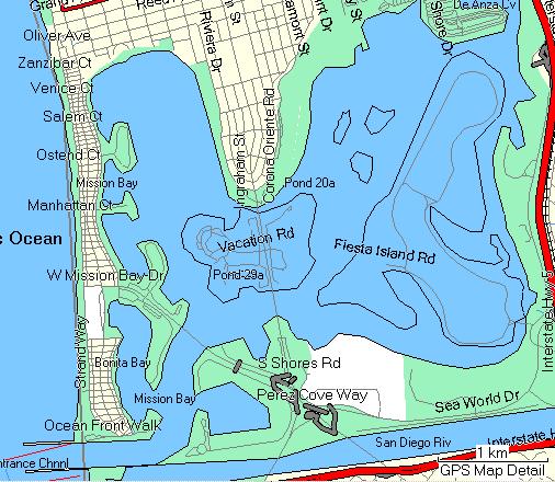
Some bodies of water are given the names of other bodies that are far away. Example N37 08.382 W122 22.622
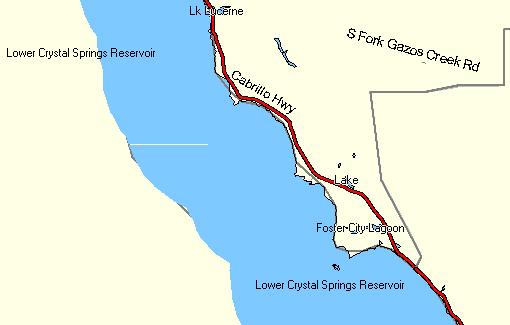
Lower Crystal Springs Reservoir is actually here: N37 31.241 W122 21.788
Foster City Lagoon is actually here: N37 33.915 W122 15.917
Some parks and military installations are mislabeled too. Example N32 50.010 W117 03.391
Mesa College here should be Mission Trails Regional Park
-
There is no royalty fee on GPS technology. It's completely funded by the regular tax base. <insert witty, though simplistic and misleading, comment about relative importance of funding health care vs. finding tupperware hereThis is a cash rebate that recognises the ten billion dollar investment of the US public in gps technology. The US govt kindly decided not to charge a royalty fee for each gpsr sold, so Garmin, altruisticly, just gave it back as an invisible rebate.>
-
For puzzles like this, where it's something I happen to know and I recognize what it is immediately, I make the challenge to see just how fast I can decode it. Got it in about 15 seconds using very common software. Maybe a couple more seconds if I include the time for that bloated software to load.
I think anyone not already familiar with the idea, but willing to try, should be able to google enough to figure it out eventually.
-
Some Garmin installations seem to insist on C:\Garmin unless the product is already installed somewhere else. Sometimes regardless of whether the product is already somewhere else.
If you don't mind mucking in the registry, you can try looking in HKEY_LOCAL_MACHINE\SOFTWARE\Garmin\Applications\MapSource and changing the InstallDir if it exists.
See what other C:\ folders you can find in HKEY_LOCAL_MACHINE\SOFTWARE\Garmin or HKEY_CURRENT_USER\Software\Garmin and change those too.
-
The POI loader will also accept GPX files. Does it work if you export as that?
-
It's not on the list of published tests, but I think they sometimes do interference testing out of Eglin AFB that might line up to where you were.
-
It sounds to me like the Chief was feeling embarrassed and was blustering for the camera mostly. Probably in a week or so it will drop off the town's radar.
-
-
It annoys me when my speed is jumping from 0 mi/hr to 2.2 mi/hr and then suddenly to 3.2 mi/hr when hiking on a trail with a lot of small switchbacks.
I have the same grievance about a Vertical Speed as well.
Do you know how to increase a sampling/averaging interval for these values (e.g. from 10 seconds to 1 minute) to make these values more stable?
This may not be quite what you want, but you can change one of the fields to be the average speed. I think it's the average from the last time you reset the trip data.
-
First try setting it to new location / auto from the satellite screen.
If that doesn't do it, try a master reset. You'll lose your settings though.
-
Thanks for all the info, battery saver mode was one. I'll see what happens. Why have a feature like that if it isn't any good?
Not everyone uses a GPS for geocaching. 30 to 50 feet accuracy is just fine for getting yourself back to your deer stand or camp, and it may be well worth the trade-off for extending battery life.
or your car, a path, a road, etc. If you're lost, keeping your batteries good for as long as possible is a good thing. (standard caveat for not relying entirely on electronics for keeping you not lost goes here)
-
There are some free (not routable) topo maps for Canada here that might be useful for your Venture, depending on how north you are in Ontario.
-
There's some misinformation here.
Two parts of the nav data will tell the receiver where satellites are.
The almanac takes 12.5 minutes to load completely. Your receiver get it from one satellite, but it tells it about all the satellites too so it knows where to look for them. This can be months old and still be good enough to get you started. If you don't have the almanac, the receiver needs to start looking for everything and it takes a little longer. It can also start working from a partial almanac even if it gets holes in the data from breaking lock. But you can't really calculate a position using just the almanac.
The ephemeris takes 18-30 seconds to load. You need to get this from each satellite that you start tracking. This is what the receiver uses to navigate and it's only good for a couple of hours. If breaking lock puts holes in the data before it's done, you'll need to wait until the next 30 second repeat to use that satellite.
-
How long do you give it for the accuracy to change? It will take several minutes to get all the corrections. It may even be showing 'D's when it has the orbit and clock corrections but not the full iono grid yet.A note about "estimate of accuracy that the GPSr reports": On my Legend HCx, the reported accuracy does not take into account WAAS. If I am getting a accuracy estimate of say, 15 feet, without WAAS, then turn it on, it still shows 15 feet... I would expect it to change somewhat. Same thing if I turn it off: no change...
--Bill
One thing that WAAS will do for the accuracy estimate is make the estimate better. In particular, it will have a better idea of how big the ionospheric error may be when otherwise your GPSr basically has to guess. That's why sometimes people see the EPE actually get bigger when they turn on WAAS.
-
I think that the Legend will search all the possible WAAS PRN's if it doesn't know which to use. So if it doesn't seem to be doing that, a full reset should fix it. But my memory may be faulty on this.
-
N 49 03.300, W 106 57.052
Southern Saskachewan
Grasslands National Park
About 3.5 miles north of the Montana border
More than 43 miles from the nearest cache
More than 300 miles from home
I don't think I've ever been closer than about 180 miles to that point, not including fly-overs.
-
In each unit, AFTER the wipe, there were two files in the unit's memory: an approximately 16MB file that is the basemap, and a much smaller file (approximately 256KB) with a name like CRITMEM.MEM (The names were different for both units, but the sizes were very close.) It has occurred to me that if I, as a programmer, had to keep track of what satellite is sending a WAAS signal, I would probably store it in a file with name like CRITMEM.MEM. I would also probably store tracks and user-preferences and such in there, and it might get bigger with continued use. (I'm wondering if there are more files are stored in a unit that hasn't had a memory wipe, and what they are.)
So here's my suggestion: what if that small file were copied from a unit that got the WAAS-change notification to a unit that didn't? (Your post mentioned a friend with a more accurate GPS.)
and my request is that anyone with a WAAS-working Meridian send me a list of files and their sizes living in memory on their unit. (That data has to be in there somewhere, it's just a matter of finding it.)
I have a Meridian Color with v5.36 and another with v5.40 and I would be willing to update to another firmware if need be and if available. Does someone out there have a MeriColor with 5.40 or 5.36 and working WAAS (correct satellite numbers)? I would be willing to try uploading a CRITMEM.MEM file into my unit to see if this takes care of the WAAS-satellite problem.
There are numerous links to the How-to-backup-a-basemap on the web. Just make sure to ignore the part with Clear-All.
GWPouch
I tried replacing the CRITMEM.MEM and FIRMWARE.BIN files with versions from my friends Explorist XL but it did not work. The old and new CRITMEM.MEM files were of different size. After restarting the file was always back to it's old size. The european firmware update 1.55 fixed the problem for me. Good luck.
That sounds like the software detected that the format of CRITMEM.MEM was wrong for its platform or version and re-wrote the default values.
If they are storing the binary information in a way that's close enough to the original WAAS almanac messages, I might be able to poke around in those files and find something to tweak. If anyone's interested, I can send you my email address.
But if it has some kind of checksum or security/integrity protection in there, I'm probably out of my league.
-
I think the best part about duct tape is that it's so cheap.
With moleskin I would always put off using it until was already getting hot spots. Then I would try to use as little as possible and it would be more likely to shift out of place. Both those things would limit its effectiveness.
With duct tape, if there's any remote chance I'm going to need it, I can just put on a huge piece without any qualms.
But if you've found cheap moleskin, then that benefit is less.
The best socks I ever had were Thorlo trail-running socks. They fit so well it was like giving my foot a hug.
-
I've done that particular virtual (intentionally and for real). The Germans have already found it and the owner doesn't seem to be monitoring it.
There doesn't seem to be anything to answer besides an inferred "What's here?", and 75% of the gallery will answer that.
I wouldn't condemn anyone for retro-logging it if they had actually been there. I wouldn't do it myself, but that's probably mostly because I wouldn't care enough. But if I was going to be there anyway, I would just wait until May and log it then.

Garmin GPSMAP 60 CSx - Accuracy Expectations
in GPS technology and devices
Posted · Edited by GPSlug
Fair enough. It just sounded like you were indicating that the EPE didn't include the geometry. I could see you had a good background in this, so I wanted to make sure to back up what I was saying.
The problem with a green/yellow/red indicator are that one application's green is another application's red. Even among users of the same handheld, the threshold for green is going to be much bigger for a hiker who just wants to get back to the road than for someone looking for a pill bottle in a field of rocks. And you still need to base that threshold on some quantitative estimate of accuracy, like the EPE, so you don't get rid of the problem of needing to make a good estimate. The EPE, as questionable as it is, still gives you the choice to decide if it's good enough for your situation. Maybe they just should have bigger disclaimers on how much you can trust it.