

GPSlug
-
Posts
388 -
Joined
-
Last visited
Posts posted by GPSlug
-
-
I've been tracking 4 WAAS satellites at once for the last few days.
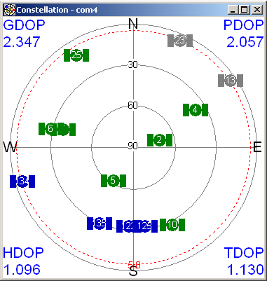
(the blue ones)
122 (Garmin 35) is now pretty much due south for me. The new ones are currently 125 (38) and 135 (48).
All have valid corrections.
-
The first thought that comes to my mind is jamming of the GPS signal frequencies in your area. I had the same thing happen to me a couple of months ago on a road trip. When I got to a certain area, my GPSr stopped receiving any signals. Our (my wife and my) remote keys to our new car mysteriously stopped working too! On our way back home, we started getting GPS signals again in about the same area where we first lost it. The fact that you're in a military environment makes this theory even more plausible.
 There better not be jamming on Diego Garcia, considering one of the GPS control segment monitor stations is there. We kind of need those orbit calculations.
 -
Thanks, Red90!
I've got mine going on my Dell Axim x51 with an NMEA serial link.
-
Menu bar View | View in Google Earth.
-
It looks like WAAS will finally be usable in areas that is previously was not. I have a couple questions for the experts: (1) does receiving two WAAS signals improve accuracy over receiving only one? I think I was told that Garmin uses only one signal;
That's not how it works.
Each WAAS-type (SBAS) station transmits the same information for the same service area. The improved performance comes from the fact that your GPSr now has additional or enhanced information with which to calculate a solution.
The advantage of having more than one SV covering a service area is availablity: in some local terrain, your GPS might not see one WAAS satellite, but could still receive the same signal from another.
-Wlw
You can also get a little extra geometry by just ranging off the second WAAS satellite. A fairly minor improvement, but an extra measurement is an extra measurement.
Theoretically, you could mix the messages from the two satellites to get your 'D's a little faster since the same messages don't come out at the same time. But that's forbidden by the spec because they don't guarantee that it will be compatible, even if it probably is most of the time.
2) does WAAS really improve accuracy? - I've noticed with my 60c that the EPE does not change when receiving "D" corrections. In fact, I've seen EPE of 6 feet without WAAS. I know that EPE is computed and may not reflect reality.Has anyone run tests with two identical units side-by-side, one with WAAS enabled, and one without? I think a test like that would be insightful. The track logs could be downloaded and compared to see the dispersion around a known location.
First of all, the EPE will be a better estimate with WAAS than it is without. The errors will be better defined. WAAS tends to be very conservative with it's error bounding because it's more concerned about integrity then accuracy (can I really trust this system to make my final landing approach for me?). Your GPSr probably shaves some of the conservativeness off of the EPE, but it can't necessarily be directly compared to the non-WAAS number.
Secondly, I don't know how Garmin handles the case with some 'D' and some without. If you don't mix them in the solution, you might have a solution with 5 'D's which might not be as good as 8 no-'D's was. If you do mix them, you'll probably de-weight the no-'D's and have a similar but muted situation where you don't have as many "good" measurements.
Lastly, not all 'D's are created equal. There are three corrections in WAAS, the slow orbit correction, the fast clock correction, and the ionosphere grid. (see the secret screen shots above) The 'D' probably shows up as soon as it gets the fast and slow corrections, because that's enough to get started with. It takes a little longer to get the iono grid which is why you might see the EPE go down further after the point when it first gets all 'D's.
-
...
Looks like Galaxy 15 will be assigned Garmin 36; I wonder what PRN will be assigned to Anik F1R. Also, I wonder what the official designations for the satellites will be.
...
According to this, 123 (Garmin 36) and 125 (Garmin 38) are reserved for the testing period (at least) for either of the new ones. So it's possible we were seeing either one using 123 at one time or another.
It also seems to indicate they might in the end be 135 (48) for Galaxy 15 and 138 (51) for Anik F1R.
-
123(36) is now not transmitting anything. Or at least not enough to lock on to.
-
It's reporting that it's at -28877528.24, -30720388.32, -18214.80 (ECEF), which is 133.23W.
-
An update on WAAS 36: this morning it appears that I was receiving differential data from 36 on my 60c as the other satellites were displaying a "D", one-by-one. I did not have any other WAAS satellite.
In addition, satellite 36's location was displaying on the satellite page as being south-southeast of my location (Seattle, WA area), near the 45 degree circle. Previously it was displaying as due north on the horizon, which I inferred was the default location until it received accurate data.
Confirmed. 123(36) is broadcasting in "test mode" (flagged as not usable for aviation purposes but available at your own risk).
Curiously, though, it's not listed in its own almanac. So you might see it use 36 for a while and then it will switch to another one like it's told (depending on your GPSr firmware). (edit: actually the almanac keeps changing)
Also of note is that 35 and 47 have been occasionally flagged as "bad health" the last couple of weeks. It looks like Inmarsat is moving AOR-W a little. Some of the time the health has been set to 7 (ranging off, corrections off, and integrity off) meaning it’s totally unusable. For the last day and a half, 35 has had a health of 1 (ranging off) meaning you can get corrections but it shouldn’t be used in the solution. You’ll probably see a hollow lock bar but get ‘D’s anyway.
-
I have a question about the external antenna. If you hook one up to a CSx, will the Sirf chip still be used to determine your location, or will the external antenna do everything.
The external antenna is just feeding the RF signal into the same processor (the Sirf chip) but from a different source. So yes, it's still the Sirf chip. The only difference is the position being reported will be the position of the antenna, not the position of your handheld.
There is such a thing as a "smart antenna" where the processing is in the antenna and feeds out position data like NMEA strings (think of it as a GPSr with no display). But that's not what would be happening in your case.
-
I sent mine in for repairs since it was still under warrantee. The rubber was loose and the click stick was flaky. What I got back was either brand new or refurbished (brand new outer shell), I can't tell the difference.
If you're not under warrantee or you don't want to do without for a week or two, there are various glues people have used with success. ISTR some mentioned a couple of months ago if you want to page back (or wait for search to come back
 ).
). -
Can you imagine if they could track you down because of your GPS. That means that every army unit or equipment using GPS (tanks, plans etc.) could be fired upon just by beeing traked by the ennemy who would know their exact location???
Thats it!, thats what I will mention to him on Monday, that should clear things up. If he still persists I will tell him to crawl back under his rock!
Thanks much for the informative information.
Lakedawgs
Duh! Only the US military can track them. That's why they don't mind if the enemy is buying commercial GPSr's.

-
I agree with you absolutely.
I would like to find some documentation for this to shut up my left wing nut friend.
Lakedawgs
Here's the spec. Ask him to find anywhere it defines what the user segment transmits (hint: it doesn't). It would be difficult for a hundred different manufacturers to be transmitting this information without a spec. Or is it a ginormous international conspiracy they're all in on?
On the other hand, if you have a cell phone with A(ssisted)GPS and you turn it on, your provider knows where you are.
-
On my old laptop the USB comes up as COM5 or COM6 and on the new laptop it comes up as COM3 or COM4. Neither has a serial port. Go figure. All it means is that setup will require a bit of sorting out of the COM port assignments.
Some of them even change COM ports when you change which USB port it's attached to. If you can't auto-detect the port, you can see which ports are active in the Device Manager (right-click My Computer, Manage -> System Tools -> Device Manager -> Ports).
-
Wow. I've heard of it, but had no idea how soon it was coming. See the USCG Nationwide DGPS page. There are 35 stations already, and they expect full US single station coverage by the end of 2006. No current coverage map for NDGPS. I believe NDGPS is an entirely different (newer, more accurate) DGPS system than the older (current) USCG Maritime beacon DGPS system
So - where / when are the small portable NDGPS receivers, and the handheld GPS receivers that go with them? And the High Acuracy version in "several years" will be accurate down to 10cm accuracy?
Hmmmm.... these could take the fun out of geocaching, or at least force it to evolve. Time soon for the High Accuracy Geocaching website (www.ha-geocaching.com). Better register the URL, Jeremy.
Regular NDGPS is the same as the Coast Guard beacons, just spread out inland. They've improved the accuracy of the coastal and inland corrections over time (not to mention it's much better since SA went to zero), but they are the same RTCM messages they were before. Your handheld can use this data now, the problem is the beacon radios to feed it in the serial port would be something else to buy. As wireless data costs go down, getting the corrections over IP streaming from your phone might take off.
The high accuracy stuff they're developing uses a smaller message format to fit more information. They're playing with atmospheric modelling, dual frequency and carrier phase data to make this happen. One problem is overlaying this on the current broadcast without disrupting the legacy beacon users. The development is being done largely by the US Coast Guard, and there are just too many boats out there that need to work on the old system. There's still a lot of work to do on this and a lot of procurement to distribute it around the system.
Of course, it's hard to tell how much this will filter down into the hobbyist handheld market. To get the 10 cm, you'll need dual frequency carrier phase tracking. It's some of the same technology used for expensive survey systems, but not as accurate because of the long distances from the reference receiver and the limited bandwidth they have to work with. The new L2C signal will help drive the cost of dual frequency down, but there's only 1 satellite with it so far and it will be several years before there are enough put up to be useful.
-
So if it says 0000.00 km enter 1/4 of a KM so enter it as 0000.25 because 250 meters is one quarter of a kilometer.
Am I right or have I missed something?
And I've never found a way to get more than 10 meters of resolution. After a few waypoints in a multi, that really starts to add up.
-
Where you've found the list of the installed maps in the map options, there's a check box next to each map. Just uncheck it to hide those layers.
I have MetroGuide and Topo installed with the MetroGuide hidden so what I see is the Topo, but the POI's are still searchable if I want them.
-
Yes, not only is it more centrally located, it's transmitting a stronger signal than the Inmarsats are. They are also adding reference stations in Canada and Mexico to improve the ionosphere coverage. It should be a nice improvement altogether.
-
This is why no one does this.
Except everyone who does surveying.
No, everyone who does surveying with GPS does the correcting in the measurement domain (the range and accumulated carrier phase), giving an accurate baseline between the two points. If anyone is doing surveying with position corrections, they aren't getting anywhere near the accuracy or robustness they should.
-
Anyway, the reason I'm asking is that most corrections are range corrections. If all you have is a file of positions, you're pretty much out of luck.
Position corrections would be if you had one GPSr on a known point and another on the unknown point, both reporting positions. If the known GPSr records a position that is different from the known position by x meters (or degrees or whatever) east and y meters north (and z meters up), you subtract those amounts off the position reported by the unknown GPSr and you've corrected the position. The catch is that to be useful at all, you have to use positions from the same time and know that both GPSr's were using the same satellites and the same ephemeris (set of broadcast satellite position parameters, which change periodically). This is why no one does this.
Range corrections are what is used in the RTCM corrections transmitted by Coast Guard beacons. The known GPSr differences the measured range to the satellite with the calculated difference between its known position and the broadcast satellite position to figure out the error in it's measured range (from inaccuracies in the broadcast satellite position, atmospheric errors, reflected signals and noise). Most of that combined error will be the same for the same satellite being measured by the unknown GPSr, so it can back that error out of it's own ranges before calculating its position. This works pretty well regionally while the errors are still highly correlated and the two GPSr's don't need to be using all the same satellites. If you had the right kind of radio, you could feed the Coast Guard corrections into your GPSr in real time. To do it after the fact, you would need to have recorded the range measurements, which consumer grade GPSr's typically do not do.
Another kind of corrections are orbit and clock corrections. Which use a lot of known GPSr's to calculate more precise satellite positions and clock errors. WAAS uses a combination of orbit and clock corrections and range corrections.
-
llbean.com is showing $269 for a Vista and $169 for a Legend.
Sounds you've got yourself an eBay opportunity.
-
Is your data positions or range measurements?
-
Are you sure it's degrees-minutes-seconds you want?
Most stuff in geocaching is in degrees and decimal minutes (DD MM.MMM) rather than degrees-minutes-seconds (DD MM SS.S).
To convert from decimal degrees to degrees and minutes, the whole number part is the degrees and multiply everything to the right of the decimal point by 60 to get the minutes.
So 34.56789 becomes
34 degrees and
0.56789*60 = 34.0734 minutes
-
Has anyone used the Navtech software supplied with the dell axim 51. Does it do automatic magnification or can you do manual mag.
Does that only come with it if you add on the GPSr option? Because I didn't get anything with my x51.
 There better not be jamming on Diego Garcia, considering one of the GPS control segment monitor stations is there. We kind of need those orbit calculations.
Garmin Software For Pocket Pc Pda Setups?
in GPS technology and devices
Posted
Now I can't figure out how to get load waypoints into the Que application (except for one at a time manually). I'm thinking it should be easy, but I can't find it anywhere.