


GPSlug
-
Posts
388 -
Joined
-
Last visited
Posts posted by GPSlug
-
-
GPSlug, looking at your profile and posts I take it you know what you are talking about. Is there a link you could point me to to learn more about the WAAS almanac?
The link is in my previous post. As you can see, it's an expensive copyrighted document. But basically the type 17 message has the health/status, rough xyz position, rough xyz velocity, and time of applicability for those values for up to three GEOs.
-
The WAAS almanac is a single one-second message (or two messages if there are more than 3 satellites) that's repeated at least every 5 minutes.
? Where did you get this from? Your not confusing WAAS with broadcast DGPS are you?
Oops, forgot this
 ...
...References:
RTCA DO-229C, "Minimum Operational Performance Standards for Global Positioning System/Wide Area Augmentation System Airborne Equipment", Appendix A, Wide Area Augmentation System System Signal Specification, Table A-25: Message Content Broadcast Intervals
-
The GPS almanac is spread over 12.5 minutes.
The WAAS almanac is a single one-second message (or two messages if there are more than 3 satellites) that's repeated at least every 5 minutes.
-
Another possibility is that you were seeing the EGNOS Test Bed satellite (33) from Europe. It's apparently has been down for maintenance since the 4th. If that's the case, it wouldn't have been doing you much good anyway since you're out of the coverage area.
-
Can you tell me what the DOP values mean?
-
Is there a PC program anywhere that will show GPS satellite configuration similiar to the GPS screen? Given your present position and time of day. Or maybe a website? Something that will show the entire configuration.
Then, is there information anywhere on how best to take advantage of this knowlege? Like maybe time of a 'best' configuration? Satellite status?
GPS planning software is common in survey packages, but also often available as stand-alone. Here's one from Trimble. You can download and load in the current "Yuma" almanac from the US Coast Guard to make sure the information is up to date.
-
So what's 122(35) saying? It's been stationary for a few days but still no ranging signals.
Still there, still not good enough position for ranging.
-
135 (47) has just set itself unhealthy and gone away again.
-
If the number's higher than 32, it's WAAS (or other SBAS).
And for your "also", these DGPS stations?
-
Worked fine for my Legend. The computer sees it as just another serial port.
-
GPS satellites are 1-32 (although #32 was only used briefly a long time ago). SBAS (e.g. WAAS) satellites are officially 120-138, but Garmin subtracts 87 from that for display purposes.
-
I am new to GPSr's and have already learned a lot from this forum. The almanac has me puzzled. Once you acquire the almanac for the first time will it not update itself during later use? If not and you have to update it manually will using "New Location" or "Restart Search" in the options menu reacquire the almanac?
The almanac changes slowly and the GPSr should be updating its saved copy when it changes significantly.
"Restart Search" should make the GPSr start over on its quick search where it assumes its current time and last known position are good enough to use a tighter Doppler frequency window. This is useful if you started it inside and it has already given up on the quick search and is doing a slower search over more frequencies or maybe eventually satellites it hadn't thought were visible. Once you are outside, restarting the quick search might get you going faster. There's no reason to throw out the almanac here.
"New Location" with an entered position should still use the almanac but start the PRN and frequency search for that new location and its current time.
"New Location" with an unknown position won't use the almanac except maybe to only start with known-healthy satellites. The GPSr will do a similar wide open search if it's lost its time or hasn't been turned on for so long that it doesn't trust the time and/or almanac any more. Once it has an intial position and time it can go ahead and use its stored almanac if it's trustworthy. Once it gets one satellite, its time will be plenty accurate enough for searching.
Note that I'm speaking in general terms and don't know the details of Garmin or others acquisition schemes.
-
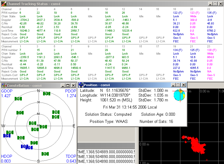
I'm currently tracking 4 WAAS and 12 GPS (plus 1 OmniSTAR) on a NovAtel ProPak-LB.
122 (35): Seems to be just about done moving. Velocity is down to under 3 meters per second which is close to the normal orbital wobble. It had been up over 10 m/s during the move. Good corrections. Still doesn't report a good enough position for useful ranging.
134 (46): All is well. Has been showing a good enough position for ranging for the past couple of days.
135 (47): Good corrections, not good enough position for ranging. In test mode but WAAS has a track record of being good in test mode. The data is coming from the same source as the operational GEOs, so go ahead and use it as long as it isn't for safety-of-life.
123 (36): Was missing for a few days but has been back for the last hour or so. No useful data coming out of it except the fact it's in test mode. 135 reports 123 has bad health so it doesn't show on the plot.
-
I haven't had any problems with WM5 that came already on my Dell Axim x51.
It might indeed be something about the smartphone variant.
Although I recall there was something in a thread about the installer used by Cachemate didn't work with square and landscape screens. Check out here or at smittyware if you think that might be the problem.
-
Jake, your location in Maine is the problem. Take a look at this page about the changes in WAAS coverage. Officially you will be without WAAS coverage through the summer, though I think another satellite is undergoing testing and sending WAAS corrections for your area. Hopefully Peter or another more knowledgeable forum member will drop by and set me straight if I am wrong.
More info from GPS World
The FAA notice doesn't tell the full story, however. Two new WAAS broadcastingsatellites launched last fall. PanAmSat (133W) began broadcasting in test mode
with corrections full-time this March, and Telesat (107W) is scheduled to
begin the same mode on or around April 1, 2006. The FAA announcement does not
take into account either of these broadcasting satellites.
So if your GPSr can be convinced to use it, and you promise not to try to land aircraft with it, you should be able to use Telesat (probably with PRN 138 (Garmin 51)) in Maine in a few days.
-
June 2006.
Planning ahead are we?

-
None of them are effectively "ranging" at the moment.
Current details:
122 (35) and 134 (47) both have in their almanac "122 is here and completely healthy and 134 is here and completely healthy". And in each of their ephemeris messages it says "here is my position, but it might be wrong by 3-6 kilometers which is too big for me to correct for in the correction messages". So you could range off of them and use them in your position solution, but it would be a bad idea if you weren't deweighting them to the point of uselessness.
135 (48) is saying the same about 122 and 134, but is also saying "135 is here and completely healthy, but 123 is crap". It's ephemeris is saying the same thing about having a big position error.
123 (36) is saying "duhhhhhh!
 " (Well, really it's giving message zero filled with zeros. Same thing.) But I've had solid code lock on it for 4 days straight.
 -
MetroGuide North America will cover Canada and the U.S. and is compatible with the Legend. But he would undoubtedly need to reload maps from a laptop, since they won't fit in 8MB for the whole way, especially if passing by urban areas. For a rough idea, my Metroguide Canada shows about 42 MB of maps to get from St. John to Sarnia.
The Legend can't calculate routes on its own, so if he wants to follow a route he has to pre-calculate it on the PC and load it on.
With these limitations and since he has the cash, he might want an auto unit. Another in-between option is to use the Legend to feed the positions into mapping software on a laptop or PDA.
-
There are innumerable standalone utilities that will do this. Fizzymagic's GeoCalc works well.
But if you want something to embed in your own program, it's really simple...
void GetDegreesAndMinutes( double dDecimalDegrees, int &iIntegerDegrees, double &dDecimalMinutes )
{
  iIntegerDegrees = (int) dDecimalDegrees;
  dDecimalMinutes = fabs( (dDecimalDegrees-iIntegerDegrees)*60 );
}
Easy-peasy.
Edit: fixed a bug
-
If your GPSr dies you might be able to send it in so they can confirm that you deserve a new code. I have a vague memory ofl someone reporting that they were able to do that. They might need some convincing first though.
-
Nope. A GPSr will use a least squares or Kalman filter solution using all of the satellites it can. The higher/stronger satellites will be weighted more though.I'm no expert, and don't claim to be, but the way I understood it, 4-5 satellites with the strongest signals are used for the position calculations, and the rest were used as needed. My unit will "lock" on every sattellite that is not obstructed. But of course I could be mistaken, and if I am I welcome clarification.
Back to the OP. There will sometimes be more than 12 sats visible, but the added geometry going from 12 to, say, 14 is going to be a pretty small improvement. What additional channels will get you, though, is that when you are in a heavily obstructed environment (e.g. downtown "urban canyon"), each channel will be ready to pick up its signal for the brief glimpses it's available. Still this is a pretty small effect since those 13th and 14th satellites are likely down in the dirt. But it will eventually be very useful if you have your 36 channel GPS/Glonass/Galileo handheld really searching "all in view". Can you wait 5-10 years for the satellites to be up and for it to be affordable though?
-
Before last month I had a Garmin Legend. But that was stolen when I was in Brussels, along with my laptop, phone (useless there), and digital camera (old and with a broken battery latch). The rest of my briefcase with my passport was found and turned into the consulate (a handy 10 minute walk from my hotel) so it only took two extra days and $1000 extra airfare for me to get home.
Since then I've been using a Magellan GPSCompanion for Palm m500 series. I won it at the ION GPS conference 4 years ago but I never had a Palm m500 to connect it to. I kept it in it's box thinking about selling it or buying a Palm m500 on eBay, but never acted on it.
But with the impetus of being without my Legend and thanks to a helpful website. I had a guy at work solder up the serial cable (the pins were way too small for the meager skills of this software guy) and I attached it to adapter I had the foresight to buy for my Dell Axim x51 and using assorted third-party software. It's clumsy with the the cable and the two separate components and it's rather fragile, but I'm able to get by with it until I decide what replacement handheld I should get.
Edit: BTW, since I was travelling on business, the company I work for is being kind enough to replace the lapto and phone since I was using them for work.
 Also, of course, the extra travel expenses.
 -
Are the "Do Not Use" flags on the new satellites turned off yet? My Magellans are not yet using them, and in the past Magellans have been pretty good at turning on the corrections as soon as they are available.
The new ones are still set to "Do Not Use" and don't exist in the almanacs sent by the old ones.
-
Well, it's called GPSolution, and it's free, but it only communicates with NovAtel* GPS receivers. I've configured one to have 6 WAAS channels assigned to 122, 123, 125, 134, 135, and 138 so I can watch what's happening.Which software is your screen shot of?*Disclosure: I work there, but I'm not trying to sell anyone anything.

 Also, of course, the extra travel expenses.
Pc To Gps
in GPS technology and devices
Posted
Are you using a USB-to-serial converter cable or a built-in com port?
Either way, to see if Windows recognizes it at all, right-click on My Computer and select Manage. Then select System Tools | Device Manager and look for Ports in the right pane. Under that, there should be something with "(COMx)" listed (where 'x' is a number) if you have any recognized serial port.