


GPSlug
-
Posts
388 -
Joined
-
Last visited
Posts posted by GPSlug
-
-
Hi I am new to this and would like opinions on Garmin venture cx or garmin etrex legend cx. Which is the best unit for geocaching. I don't seem to see a difference in their descriptions. Please help.
They're basically the same.
The Venture Cx doesn't come with a memory card. So if you are buying a bigger memory card anyway, or can get a 64 MB cheaper than the difference in price (most likely), go ahead with the Venture Cx.
Also, according to Garmin's comparison page, the Venture Cx doesn't have the Tide Prediction utility, which may or may not be important to you.
-
Incidentally, if I force 3 to be tracked and to be healthy (on a professional grade receiver), this happens:
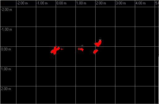
The blob on the left is an uncorrected position without prn 3, and the rest is when I add it in. The blob in the middle is because it was de-weighted some when the locktime was low. The scale is meters.
It's a little bit far for one satellite to drag it over when the HDOP is already < 1, but not extreme. Close to the noise for a consumer handheld anyway. Not that this means it's reliable to use. I was just curious.
-
Typically you don't bother tracking an unhealthy sat.
All three of those have all of their health bits set, which is to say, as bad as it can get.
3 is the only one visible to me just now but my Legend isn't even trying for it.
-
Heck, I've been known to pull out a road atlas during a flight and track my progress that way. The shape of a lake or how a divided highway enters/exits a town you're passing tells you where you are. Unfortunately, that limits my nefarious plots to cloud-free days.

-
The problem is likely the "ultra II" part of it. There have been a lot of reports of these not working in Garmin x models. See previous threads.
-
data cable,...I would second the Garmin eTrex Legend. It's a very good unit for a very good value. You could get a slightly cheaper unit, but for the couple bucks you save, you lose: higher-resolution screen, better user interface, WAAS, mapping, ... -
Regardless of whether someone tries to manipulate it,
I'll take GPS week 1405, 496814 seconds (2006-12-15 18:00:00 UTC).
-
You can hide whichever tiles of the City product you want on your GPSr and unhide them when you want them back.
-
It's broken up into sections (tiles) and you choose which ones you want. How much area you can load on your Vista CX will depend on how much memory you have to load it into.* If I buy a program, say the Topo one, will I have an entire topo map of the US or do I have to pick certain areas (the MapSource that came with my Vista CX made it soundlike you choose certain areas)?
You can load both but it doesn't blend them into one image. In areas of the map that have both loaded, it will show City and hide the Topo unless you deselect that City tile in the map info settings.* Can I download both the Topo software and the City software on my GPS at once? If so, will they just be combined together or do I have to go through a process to switch between the two?
It depends on the size of the region you want to cover. I think you could fit both for, say, a couple of counties (depending also on the tile size of the City Select/Navigator product you have). If you travel farther and don't want to reload maps frequently, you'll probably want a bigger memory card.* If I could download both programs on my GPS at once, how much space would it take? Would 64mb be enough, or would I have to buy a bigger memory stick? -
For anyone who is communicating to Garmin about this, you should really avoid saying anything like the error being always the same amount and in the same direction.
GPSr hardware problems don't really do that. They'll just see that as a big red flag that says "wrong settings" and it will be uphill from there.
So unless you have a big pile of data to back it up, leave that part out. Otherwise, it's most likely just coincidence anyway.
-
Just got a bunch of delayed emails now. Missed out on a couple of possible FTF's.
-
There should be three digits, like 11U
And if it only gives you 2 digits, the letter is redundant. It isn't necessary because it can be derived from the northing.
-
Measurements taken at different times are quite a different thing from measuremets taken at the same time in open sky. I can certainly see two receivers with the same satellites being almost always within 10 ft. But you also have to make sure neither user is blocking that open sky with their body.As stated above by someone any closest to pin contest will prove how wrong you are.If I mark the same location 100times over 10days I will not get the same coords everytime, acording to you I should. There would be no reason for position averaging to get good coords if Commercial grade gpsr were that accurate.
-
Is this a localized problem to Canada,or should I be conserned here in the States.
I'm getting 3D Diff locks and am recieving signal from 35.
If it's working for you with 35, don't sweat it. It'll use the new ones eventually when they get out of test.
-
I've also just used the POI's as a handy yellow pages.
A few times I've wanted to call a business to get their hours or make reservations while in the car already. Why pay for directory assistance when you have a handy electronic phone book?
-
I don't think you have to worry about the receiver forgetting about the new GEOs once it has the almanac for them.
The almanac messages for WAAS only have 3 satellites in them. To get out the information for 4 sats, it has to spread it across two messages. There is also no flag in the almanac message saying, "this is all you're going to get".
So, in the current case, the receiver can't assume that that the almanac message it gets from 35 or 47 overrides the almanac messages it got from 48 or 51 because it doesn't know if there will be more messages with more satellites later.
The messages are kind of additive by nature. The only way to "remove" a satellite (without a memory reset) would be for the receiver to figure that a particular satellite hasn't appeared in any message for some really long time.
That was confusing the way I wrote it. I meant that, sometimes, when I turn onthe GPS72, I see both #35 and #51 (a mix of old and new), altho #48 and #51 were
there when I turned it off. I'm not sure which almanac would win in such a case. Maybe
a superset?
It's probably just starting with the two highest known satellites as being the most likely to not be blocked.
-
The GPSr only use 4 birds at a time for location fixes (best is one overhead, and three scattered around the horizon). Multiple fixes allows it to choose the best set to use - at that time. As you move and signals get blocked (trees, mountains, you...) it can switch to another set and still keep your position. Also the birds are moving which just adds to to the fun.
This is an all too common misconception. A GPSr will use all the sats it's able to for each solution, not just 4.
-
Is there anybody famous for other than acting? Politicians, sports figures, teachers, authors etc?
Famous teachers?

I'm having a hard time thinking of any famous teachers, let alone famous geocaching teachers.
The guy from Stand & Deliver?
The woman who was on space shuttle Challenger?
Aristotle?
-
Make sure your Legend is set to use the same Position Format as what the multi is giving you (most likely hddd mm.mmm). This is changed in Main Menu | Setup | Units.
And here's the manual.
-
I think your best bet would be to start a public bookmark list. There may already be one on some of the existing tree climbing caches.
-
I zoom in with Google Earth until I'm close enough and read the coordinates (in DMS) off the screen.
-
When I'm in my brother's car, his XM radio jams my GPSr if it's within a couple of feet. I have to turn the XM's power off to use the GPSr on the dash. It's easy to test (bars go down...bars go up...bars go down...bars go up).
-
Did you just reinstall mapsource from the disk or did you also install the latest mapsource shell from Garmin's website?
Did you try reinstalling the USB drivers too?
Another guess: running out of temporary disk space?
-
i'm new to geocaching and i'm having trouble finding caches on microsoft streets and trips i think version 2004. when i put in a set of coordinates it puts me in saudi arabia or somewhere on the other side of the globe. the help file wasn't very helpfull. it said something about gps's using different types of coordinates and that they may appear in different places on the map but it doesn't explain how to get around this. any suggestions??
thanks in advance,
tom
What are the coordinates you are trying to enter? Can you provide a screen shot of the entry dialogue?


I am leaving in the morning.. Quick help?!
in GPS technology and devices
Posted
2 ways once you've downloaded your PQ into GSAK:
In GPS | Send Waypoints, you can adjust the icon for different types of cache.
You can also set the waypoint name and description to include extra information with smart tags (like adding in %typ1 for the type and %con1 for the container size). You can also do this kind of stuff if you're exporting to a file (e.g. GPX).
Although if you don't have GSAK and know how to use it already, you probably don't have time before you leave.