


CoyoteTrust
-
Posts
101 -
Joined
-
Last visited
Posts posted by CoyoteTrust
-
-
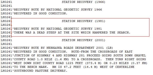
During this recovery attempt, a dead steep (or maybe it was a dead SHEEP), caused some problems.
-
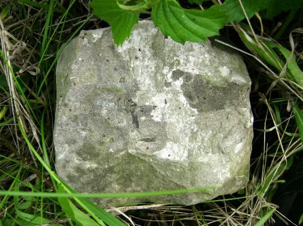
I think I found the original stone as well as one reference stone. I put it up for debate in these forums at the time. If these are the true stones, then this pic and my others will give you an idea of what they'll look like.
-
Any hints as to when the 2010 trip will be? Thought I'd be there last year but an ER visit the night before the trip nixed my plans.
-
For what it's worth I, too, have used the USGS maps (via the ExpertGPS program) as an aid. I plot a waypoint over an "X" on the map that I suspect would be the mark I am looking for, and then load it into the GPS. I still refer to the data sheets as needed, though. Either way, using those USGS maps and my own waypoint plots has made things easier in the field on numerous hunts for USGS and NGS marks.
-
TM,
Looks like BDT provided a plethora of info. One note: In December I submitted about 12 quads' worth of info and heard nothing. Earlier this month I emailed them again to ensure they got it. The reply: they got the reports, they were thankful, but they've been very busy with other stuff related to the Haiti situation. Point is, right now I'm not sure how fast they'll get back to you or anyone requesting info.
-
Thanks for all the input. That concludes my study.

-
((( deleted double post )))
-
... You have to write into the office handling your area and request copies of them.
Yes, that is still the case. They have to go into their filing cabinets, get the info on marks in the quad you request, and they send it to you via US mail. I've done recoveries on their marks in twenty-plus 7.5 Quad areas. Interesting to find a chiseled square on a small bridge in the farmlands of Illinois, let alone the actual survey disks.
-
Disclaimer: I did a few keyword searches and didn't come up with much, then did a half-arsed scan of all the threads but got lazy. So I apologize if this has been covered before and ask that no one jumps on me -- 'cause I don't deal with hurt feelings too well.

Has anyone ever contacted Groundspeak in ref. to creating a website that is dedicated solely to survey mark hunting? Meaning: it would be like the GC website -- or like an off-shoot site (as is Waymarking). A few years ago I met Mr. Jeremy at the Garmin store in Chicago; I dropped a hint/casually mentioned the idea. However I truly believe we didn't get far in the convo because another cacher was too excited to meet "The Man" and thus interrupted us.
Now playing devil's advocate of sorts: is there really a need for an off-shoot site?
Thoughts? Comments?
-
Using "MS Picture It!" (MSPI) software enables me to do split-screens, which I usually make only for the rod type of mark. And for most marks of any type that I find, I'll generally add an arrow in the setting pic.
MSPI does have tools to impose the mark's close-up shot on top of the setting pic (as this thread obv. shows), but I usually don't take the time to create those types of pics. They're very nicely done, though.
For example, this is AE2509. (OT: found in beat up condition, as most of these 'protective' cast cap & sleeves seem to be.)
-
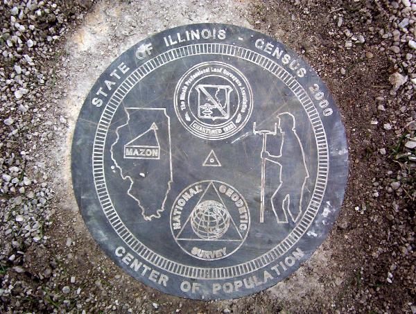
A tenacious cacher placed a geocache near the State of Illinois Center of Population mark (GC1Z7TN).
He was lucky enough to find people who KNEW about the mark while I had some trouble on my previous visits (refer to my earlier post in this thread). Now, the witness post is gone, and some of the greenery and crushed limestone (a park recreational path) have been moved to make the mark visible.
-
I've been deployed overseas for a while, and after suffering a little from survey mark withdrawal, I was pleased to find this mark at N35° 27.226 E44° 20.607.
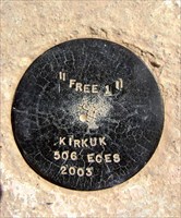
Note the stamping name, and also note it was set by the Expeditionary Civil Engineer Squadron (ECES). I'll have to talk to that unit to see if there are more marks and any other data associated with it/them.
Maybe I'll create a waymark but either way I thought you'd all like to see this. And here's a 'shout out' to my pal TeamFawlty back home -- sorry I haven't kept you updated on things but I hope all's well and that you're having fun BM hunting. Would like to team up with you and find that little copper bolt along the canal back home some time. Stay safe.
-
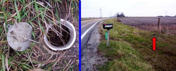
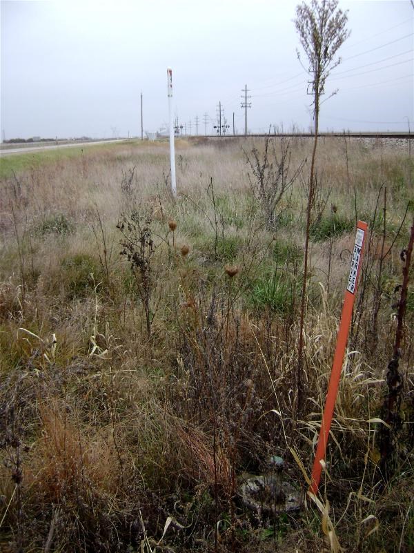
Hey, kudos "holograph" I think you nailed it. I remember seeing pipeline signs in the area but honestly didn't pay much attention to them. In the bottom-most pic I posted, I believe that white pole is related to a pipeline in the area. Not 100% sure but there are a lot of pipelines in my home area and they are 'marked' with similar white or yellow poles.
Diff Run: Good eye on that "I" being a "1". I guess I did notice that... and I failed to note that in an NGS report, hmm.
Thanks to all for the inputs & interest.
-
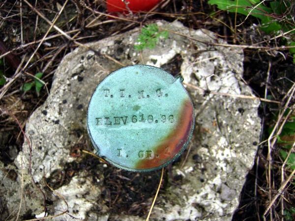
Thanks for the interest thus far. Can anyone take a stab at the meanings behind the stampings (other than elevation)?
-
Yesterday I found MF0277.
It is monumented between RR tracks and Old US 66. I've found a bunch of pipe cap type marks before, but this one was different. Maybe I haven't had enough experience in finding them, but this particular style of pipe cap was a first for me. The cap is only about 1.5 inches in diameter. Also, does anyone understand the meaning behind the stampings (i.e.: T.I.N.G. and I. GR.)?
-
holograph,
Thanks for your work on this stuff.
-
This was a good story, thanks for sharing. I think it'd be cool if these same fellas would go to ME2997 to do the same thing (and I wouldn't mind being a witness, of course).
-
I've found a few that have gone unfound by professionals. I kinda think a lot of them were also 'not looked for', as it might've been raining or something and the agency just did a drive-by recvoery so to speak.
This one ME1569 FORKED was my most recent, 20 years after a USPSQD no find. It was a tri-station but still a tough find (even with good coords) because the grass was so thick and wet, let alone the disk is no longer flush. No witness posts remain as described.
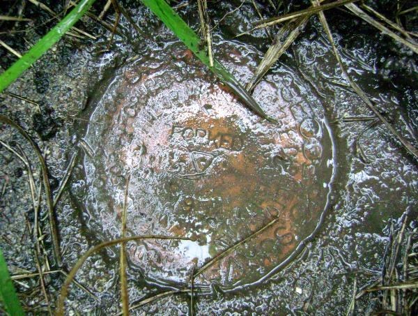
I was bummed to not find the RM's, though. I measured but didn't have a prod or anything; I'm thinking they're still there beneath that thick grass and dirt.
-
Boy, Deb certainly did bring things up to date--she posted some reports that I just submitted last night!
Same here -- my 'found' entries from October 15th are already in, whoa.
-
If we'd met that would have been a really rare coincidence...
I got another one about Bill!
A few years ago in Morris, IL, (June of '06). I was with my mom as I completed a task for her at camper/campground south of town, and we went into town for some dinner. Afterward I asked her to drive down the old river road; she'd never been on it and I wanted her to see where it led out of Morris. I also wanted to nab one mark on a bridge that I was sure I could get: MF0210.
After doing that and driving down the road, we passed an intersection where I've stopped on my own in the past to seek a mark. I noted a fella barely off the road intersection. 'Hmm, wonder if he's a survey mark hunter,' I thought. But we kept driving.
A day or so later, when I get home and have internet access, I go to log MF0210, but I see Bill93's log on that same mark for the same date I was there. So I put it altogehter to realize that it was Bill93 that we'd seen later on down the road. Sure, common sense should have told me what that fella poking around the weeds and tall grass near the intersection was up to! Too bad we didn't stop so I could say hello.
That's funnyAnd I didn't even notice any stomped down grass and weeds. Some detective I'd be. Shucks.

-
They must have quite a backlog. I see no updated datasheets for any of my reports since early August.
Ditto these folks, although I hadn't made a whole bunch of recovery attempts, none of my August submissions made it.
EDIT: Still, thanks to holograph for your work. I like to see the maps whether I've done submissions or not.
-
It's a good question. I've set up a few earth caches and anticipated that "yes" earthcaches are becoming more popular. I figured people would be really interested in checking them out, but they haven't received as much attention as expected.
Still with the flood of SO many dang micros, particularly in parking lots or in parks that don't show me anything (personal opinion), I thought that maybe setting up something different like earth caches would offer an alternative to the above-mentioned caches. I figure an earthcache is essentially a virtual cache; they're pretty easy finds, but maybe the actual learning requirement turns away some people.
I'm not putting down anyone in my area or anyone who doesn't seek the cache. Again, I just thought there'd be more people coming around.
When I recently drove back to Chicago area from Minneapolis, for the most part I only hit virtuals and earthcaches. Even now I regret not going to seek a few other EC's that were a little more off my route than I expected, but oh well.
-
Looks like Illinois has a sewer grate for its monument!
I finally got down to the area of the mark and was excited to look for it. I found this witness post but nothing else. Kicked around some dirt and crushed limestone from the walking path, but no dice. So I circled the park twice, and cannot figure out where the mark is -- if it's even monumented yet.
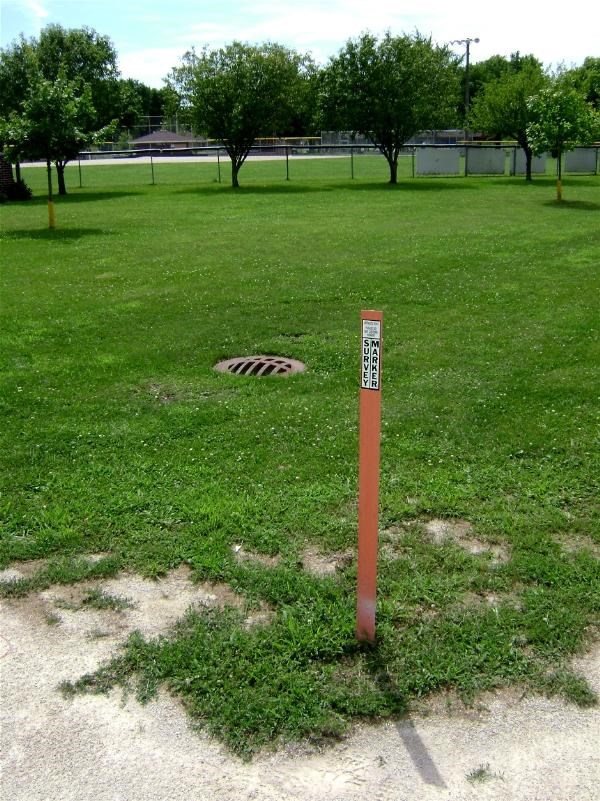
The holoscenes web states: "This station was dedicated July 10, 2004 but has not yet been accepted into the NGS database. It is located at the edge of Centennial Park in Mazon, Illinois."
I went to the village hall (closed at 12:30) and later talked to 3 locals who did not know about the mark. One person, after I told him I went to the village hall, told me "yeah it's closed the lady across the street works there and she just came home. You might ask her husband -- he's the police officer here -- but I think he's out of town."
Heh heh heh -- I always did like small towns and the people therein. My quest is to be continued, I hope.
-
Nice photos, but near Chicago, Illinois, is the last place I would expect to see US Forest Service land surveys taking place. Is there really any Forest Service land in that area?
Thanks. Based on jwahl's response I don't feel I could add much more. Jwahl is probably right in that the mark may be related to Midewin National Tallgrass Prairie in that it is a federal USFS area. Check out that link for more info and history about Midewin -- it's very interesting in that it was the Joliet Arsenal in its heyday.
The mark and bearing tree signs are hardly weathered, and they didn't stamp much info onto the sign's blocks (i.e. no date). I only suspect they are from the 1990's time period which is when they decided to reclaim Joliet Arsenal/Midewin.
Also, that NE-SW path running near my coords is a multi-use recreational path titled Wauponsee Glacial Trail (maintained by Will County, IL). It was a former railroad and sometime in the 1990's they removed the RR and eventually converted it to its present form. Maybe that, too, ties into the mark's presence ( ? ) BTW it's a great path thru the country.
I'll have to look at jwahl's link. Thanks for that info, jwahl.
June Statistics
in Benchmarking
Posted
Looks like each state expects the other state to use the weed whacker at this monument. Nice pics, thanks.