

jwahl
-
Posts
274 -
Joined
-
Last visited
Posts posted by jwahl
-
-
1) The quad shows dashed lines for the section lines. This is an indication that they do not have any definite location for the section lines.
2) The local forest service office may have corner recovery cards or other information, it should not be too hard to locate the office and try to get hold of the forest surveyor. Due to decreased funding, there may no longer be a local surveyor on the forest, in which case you can try to find information from the regional forest service office.
3) There could be something there or not, the quad position is essentially meaningless if the lines are dashed. If there is some kind of monument there, it may or may not be the actual corner. For the purposes of your geocache it probably does not matter. The data given from the parking spot are more meaningful that the actual true position of the corner.
4) Bottom line is that it is unlikely that the USFS or anyone else has any other or better coordinate.
If they did, it would likely be different by 100's and possibly 1000's of feet and not be of any help in locating the geocache.
- jlw
Ok here it goes, Ill try to explain.The marker reads as followsT12N R31W Sec 32N 1/4.The marker is at the s.e corner of of parcel#001-19656-000,which is adjoing US GOVT parcel 001-19686-000-E. I was given a parking coord only n35 40.111 w094 16.910 and told to go 296degrees for 1.20 miles. I the projected a waypoint and come up with n35 40.554 w 094 18.236 and did the 1.20 mile hike, i allowed my self abot 200'
of error distance and did not find the marker.I tried to plot on topozone but really did not know how.I was assuming the local foresty had long/lat coords for their markers, on some web site, making it easier for me.
I did however find the marker today 12-28-07 but it wasn't close to where I believe it was supposed to be.
Hence the question of a web site or Gov't Agency that had track of such markers. This was a geocache
and you had to triangulate off said marker, I did find a pile of rocks at what I believed to be the corner, I
triangulated from that coord and found the cache anyway. still the question remains, does the local
forestry keep coords on boundry markers? I called the local assors office and got brushed off(holiday weekend perhaps). I want to thank each of you personally for your insight to my questios I learned a lot, and did not get the B.S like on some of the other forums. Thanks again Red INK
-
The HK monument was set by California Licensed Surveyor named Hugo Kuehmsted in about 1931 per Record of Survey LS 00430 as it is indexed in the San Diego County survey records. So that is where HK comes from. He surveyed and remonumented a lot of corners in that township in that survey.
- jerry wahl
While staying in the Jamul area of San Diego County, CA (SE area of county) I was looking for DCO333 SD 114 SD CO DC0333
I couldn't find it, but I did see a witness post over yonder. So, I wandered over; hoping it might be a RM, or the BM itself. ...
After a couple of minutes of work weeding, I spied HK
So, who/what was/is HK? Landowner, surveyor, some kid who found the wet concrete?
Any ideas on what's going on?
TIA for any help.
The HK mark that you give the coordinates for, falls on some sort of a metes and bounds land boundary as shown on the USGS quad map. My guess without any research would be a spanish land grant in that area. Kewanah is north of that area and I am sure that he will have a better answer for you.
CallawayMT
-
The terminology naming the monuments and the context sounds to me like a specific survey of this county line. Specific surveys are often referred to in this way. For example, 'the carpenter line' on the south boundary of Colorado, versus the Kidder Line.
If there are monuments there now that disagree with the ties, then there may have been more than one survey and the other monuments are now gone.
This is not uncommon on state and county lines where different attempts may have been made to locate the line or description.
Going on that thought I found the following links describing the boundary of Maricopa County.
Which mention the Thompson survey. It does appear that it is the correct survey. Keep in mind though that there can be really nice monuments from another survey near by in this type of situation that ARE NOT the boundary. Based on the 1924 dates on these, they are probably the Thompson monuments referenced in the descriptions. There can also be monuments of a survey that are NOT accepted for parts of the boundary. An example of that is my previous example of the Carpenter line between Colorado and Oklahoma which is well monumented, but is not the actual state line.
Looking at other parts of this state legislative title 11 on counties shows there were dispute resolution processes also. At any rate the counties may have a record which may lay out the history more completely, or it may also be somewhere in the state government.
-
I would echo some of the previous comments. The first thing I would try is to see if you can find any horizontal control stations in common between the old datum and NAD27 or NAD83. There are then programs that you can feed two sets of coordinates into and get an analysis and least squares coordinate transformation. Of course to do that would require listings of the old coordinates. It used to be such data was housed on sets of 5x7 cards. I would presume that NGS would still have that data somewhere, or you might find it in some local agency where some old surveyor likes to hang on to things like that.
Since you may not need a rigorous result, even one point would be a help and over a local area you could assign a simple shift. That could be done by finding even one point from your survey and putting a new coordinate on it with your GPS.
Some old C&GS publications may give some history of NAD27 and indicate regional shifts from the previous NAD.
-jlw
I have a report of a survey done around 1915 which specifies the "North American Datum" as their control. It includes points in both Canada and the US (It's a boundary survey).
I'd like to convert some of the coordinates from the report to NAD83. Can someone tell me if conversion software is around for this datum? I could always assume it is close to NAD27 and convert from that but I'd rather do it right.
Thanks
Papa Bear
-
As an aside: I think that often the original station descriptions were written by one C&GS crew to others involved in the initial observations. In some cases monuments might be set first, then "observed".
For a tri station there might be crews to build a tower, to observe, for light keepers return to get to the point, occupied on several occasions and sometimes even later better monument the point, etc. The famous "To get to" instructions were written primarily for those initial groups to get to the point. Not much thought was made about future recovery. Thus you see "follow the tire tracks up the hill" type of things in instructions on occasion. The terse nature of some of those descriptions and transcriptions over the years can make them confusing to a modern interpretation.
In this case it does sound to me like an observer giving advice to others to reset the station at some point in the future. It would appear that nothing was done unless there is another station in the database nearby. Of course a reset station would require additional observations to tie it into the system and that work would then be external to the original levelling and be a pain to deal with and maintain.
So if you look at it in the context of an instruction rather than a final description SET can take different meanings.
jwahl
Generally, in surveying notes that state "SET.... ", it is a description of what was set, not an advisory note of what should be done.
... It is curious that there is no further description of the mark they set. ...
- Kewaneh
Exactly. Odd as it might be to suggest that a new mark be set because the old mark is being eroded; it's even odder, it seems to me, to say you DID set a mark, but then not say WHERE it is. What's the point?
Of course, the information could have been in the hard copy record that never got entered in the NGS datasheet.
Bit of a mystery here.
-ArtMan-
-
Many USGS quads were produced with a second set of marks at the estimated NAD83 positions for the corners. Some of these were computed based on estimated shifts before NAD83 was actually finished and may not be exactly correct but give a good visualization of the differences. In DRG images made from the paper quads these are often hard to clearly distinguish. I have even seen a DRG which was produced on NAD83 and the offset corner marks were NAD27, so never assume.
Terraserver imagery derives from the National High Altitude Photography program which generates the USGS DOQQ's.
DOQQ's have two sets of tic marks. One which is usually a solid cross is the NAD83 value, and the other which is dashed is NAD27. Because QQ means quarter quad these can often be found at even values of 3 minutes and 45 seconds in the Terraserver data. There is actually meta data that was distributed with the images originally which describes what the marks are.
- j wahl
I have paper 7.5 minute maps (unfortunately none later than 1982) that have dashed corner marks slightly different from the solid line corners, and say things like:
"1927 North American Datum. To place on the predicted North American Datum 1983 move the projection lines 4 meters north and 14 meters east as show by the dashed corner ticks"
-
Also my not so thorough search on issues with that receiver revealed things like having locked onto roads set (thus the position not accurate), WAAS not enabled, and incorrect datums set. Some people seemed to solve the problem with a firmware update (2.60) and others with a soft reset. Just some things to check if you haven't already.
That datum refers to the vertical datum (elevation), and not the horizontal. I would guess it stands for "Canadian Geodetic Vertical Datum of 1928).
From what I can tell, the horizontal datum described for the CSRS is NAD83. Also if there are a few of those points that you wan't more detailed information about send me an email. Most of the detailed descriptions didn't say much, no monument description at all for example. You may be able to tell about as much from plotting them up.
PS#1 It looks like your Garmin took a pretty bad hit.Actually, that's simply a piece of plastic film used to protect the screen; it was just pulling up at the corner. The screen is in pristine condition because I keep the film on it. I just got a ShieldGuard for it, but don't want to put it on a GPS that I may have to return.
...
jwahl, I look into the ones you've listed, thank you.
jwahl, how do I know which dataum is being used in that list you gave me? I don't see "CGVD28" as an option on my GPS.
jwahl, I just looked up the first one on the list you gave me, it's about a block from my workshop, nice and close! I'll check it out.
-
That datum refers to the vertical datum (elevation), and not the horizontal. I would guess it stands for "Canadian Geodetic Vertical Datum of 1928).
From what I can tell, the horizontal datum described for the CSRS is NAD83. Also if there are a few of those points that you wan't more detailed information about send me an email. Most of the detailed descriptions didn't say much, no monument description at all for example. You may be able to tell about as much from plotting them up.
PS#1 It looks like your Garmin took a pretty bad hit.Actually, that's simply a piece of plastic film used to protect the screen; it was just pulling up at the corner. The screen is in pristine condition because I keep the film on it. I just got a ShieldGuard for it, but don't want to put it on a GPS that I may have to return.
...
jwahl, I look into the ones you've listed, thank you.
jwahl, how do I know which dataum is being used in that list you gave me? I don't see "CGVD28" as an option on my GPS.
-
It also appears that the monument might be a land or property corner given some of the designations on it. Land boundary monuments are often not tied to accurate latitude longitude type coordinates, and often even if they are coordinated the values are frequently not published.
Your best bet would be to find a monument from one of the horizontal reference frames. Data may be hard to find, but try this:
http://www.geod.nrcan.gc.ca/online_data_e.php
http://www.geod.nrcan.gc.ca/hnet_e.php
It looks like you have to register and create a log in to access the information at this site.
There may be other data from the province.
- jlw
PS#1 It looks like your Garmin took a pretty bad hit. However if it works at all, I would expect the coordinates to be okay within the normal operating limits.
PS #2 here is a list of control in that area. Note primarily the ones with coordinate values in fractional seconds. I see none specifically close to your coordinate. Sorry for the formatting, I have to learn how to preserve it somehow.
STN NO NAME EAG Latitude Longitude HDA O I M YRA ELEV VDA O Q M DATUM YRA SMC COND NTS
B104521 104521 165 49 14 39.3115 122 42 12.5373 100 Y A R 2004 1.959 100 1 P 1 CGVD28 2004 1 1 092G02
B105700 105700 165 49 14 32.3589 122 40 35.1056 100 Y A R 2004 2.024 100 1 P 1 CGVD28 2004 1 1 092G02
B117598 117598 165 49 16 51.5783 122 41 22.9142 100 Y A R 2004 4.733 100 1 P 1 CGVD28 2004 1 1 092G07
B149518 149518 165 49 17 35.7418 122 38 39.9531 100 Y A R 2004 2.092 100 1 P 1 CGVD28 2004 1 1 092G07
B156018 156018 165 49 17 36.3085 122 37 24.2106 100 Y A R 2004 1.685 100 1 P 1 CGVD28 2004 1 1 092G07
B57851 85H0637 165 49 14 32.1586 122 39 4.4778 100 Y A R 2004 1.640 100 1 P 1 CGVD28 2004 1 1 092G02
B663609 85H0763 165 49 14 6.4690 122 37 21.0187 100 Y A R 2004 8.104 100 1 P 1 CGVD28 2004 1 1 092G02
B677393 677393 165 49 15 24.6699 122 39 40.1557 100 Y A R 2004 1.415 100 1 P 1 CGVD28 2004 1 1 092G07
B784975 784975 165 49 15 53.5256 122 41 21.0570 100 Y A R 2004 6.115 100 1 P 1 CGVD28 2004 1 1 092G07
B801852 801852 165 49 16 22.9213 122 39 36.4215 100 Y A R 2004 4.766 100 1 P 1 CGVD28 2004 1 1 092G07
B91694 91694 165 49 13 16.7847 122 39 53.5925 100 Y A R 2004 4.572 100 1 P 1 CGVD28 2004 1 1 092G02
B96909 96909 165 49 15 32.7160 122 36 2.6785 100 Y A R 2004 2.160 100 1 P 1 CGVD28 2004 1 1 092G07
STN NO NAME EAG Latitude Longitude HDA O I M YRA ELEVATION VDA O Q M DATUM YRA SMC COND NTS
19C175J 175-J 100 49 13 34 122 41 24 S S 6.704 100 1 P 1 CGVD28 1977 1 1 092G02
59C084 1363-J 100 49 15 54 122 41 17 S S 5.526 100 1 P 1 CGVD28 1977 1 1 092G07
59C085 1364-J 100 49 16 30 122 39 40 S S 5.366 100 1 P 1 CGVD28 2004 1 1 092G07
59C086 1365-J 100 49 17 42 122 38 35 S S 1.697 100 1 P 1 CGVD28 1977 1 1 092G07
77C067 77-C-067 100 49 15 29 122 42 40 S S 1.825 100 1 P 1 CGVD28 1977 1 1 092G07
77C068 77-C-068 100 49 14 35 122 39 11 S S 1.667 100 1 P 1 CGVD28 2004 1 1 092G02
77C280 77-C-280 100 49 12 47 122 37 52 S S 26.962 100 1 P 1 CGVD28 1977 1 1 092G02
77C282 77-C-282 100 49 14 42 122 42 40 S S 1.864 100 1 P 1 CGVD28 2004 1 1 092G02
77C283 77-C-283 100 49 16 41 122 38 35 S S 1.200 100 1 P 1 CGVD28 2004 1 1 092G07
77C285 77-C-285 100 49 14 53 122 38 35 S S 4.920 100 1 P 1 CGVD28 2004 1 1 092G02
77C286 77-C-286 100 49 13 16 122 39 18 S S 16.807 100 1 P 1 CGVD28 1977 1 1 092G02
84H0024 84H0024 100 49 12 59 122 39 50 S S 2.750 100 1 P 1 CGVD28 1996 1 1 092G02
88H0623 88H0623 100 49 12 43 122 38 22 S S 20.630 100 1 P 1 CGVD28 1996 1 1 092G02
B104521 104521 165 49 14 39.3115 122 42 12.5373 100 Y A R 2004 1.959 100 1 P 1 CGVD28 2004 1 1 092G02
B105700 105700 165 49 14 32.3589 122 40 35.1056 100 Y A R 2004 2.024 100 1 P 1 CGVD28 2004 1 1 092G02
B113480 80H1234 100 49 14 33 122 37 20 S S 4.734 100 1 P 1 CGVD28 2004 1 1 092G02
B117598 117598 165 49 16 51.5783 122 41 22.9142 100 Y A R 2004 4.733 100 1 P 1 CGVD28 2004 1 1 092G07
B149518 149518 165 49 17 35.7418 122 38 39.9531 100 Y A R 2004 2.092 100 1 P 1 CGVD28 2004 1 1 092G07
B156018 156018 165 49 17 36.3085 122 37 24.2106 100 Y A R 2004 1.685 100 1 P 1 CGVD28 2004 1 1 092G07
B166629 166629 100 49 16 17 122 38 39 S S 3.850 100 1 P 1 CGVD28 2004 1 1 092G07
B179127 179127 100 49 14 32 122 40 1 S S 1.946 100 1 P 1 CGVD28 2004 1 1 092G02
B207746 80H1235 100 49 14 32 122 36 4 S S 7.814 100 1 P 1 CGVD28 2004 1 1 092G02
B387381 85H0645 100 49 14 32 122 38 41 S S 2.158 100 1 P 1 CGVD28 2004 1 1 092G02
B463000 85H0647 100 49 14 6 122 38 20 S S 2.939 100 1 P 1 CGVD28 2004 1 1 092G02
B496315 84H0060 100 49 14 31 122 34 47 S S 14.705 100 1 P 1 CGVD28 2004 1 1 092G02
B548685 548685 100 49 13 36 122 40 39 S S 4.564 100 1 P 1 CGVD28 2004 1 1 092G02
B57851 85H0637 165 49 14 32.1586 122 39 4.4778 100 Y A R 2004 1.640 100 1 P 1 CGVD28 2004 1 1 092G02
B596015 596015 100 49 16 18 122 41 21 S S 2.118 100 1 P 1 CGVD28 2004 1 1 092G07
B663609 85H0763 165 49 14 6.4690 122 37 21.0187 100 Y A R 2004 8.104 100 1 P 1 CGVD28 2004 1 1 092G02
B677393 677393 165 49 15 24.6699 122 39 40.1557 100 Y A R 2004 1.415 100 1 P 1 CGVD28 2004 1 1 092G07
B784975 784975 165 49 15 53.5256 122 41 21.0570 100 Y A R 2004 6.115 100 1 P 1 CGVD28 2004 1 1 092G07
B801852 801852 165 49 16 22.9213 122 39 36.4215 100 Y A R 2004 4.766 100 1 P 1 CGVD28 2004 1 1 092G07
B842476 84H0058 100 49 12 48 122 38 53 S S 17.623 100 1 P 1 CGVD28 2004 1 1 092G02
B906271 906271 100 49 14 31 122 41 22 S S 1.695 100 1 P 1 CGVD28 2004 1 1 092G02
B91694 91694 165 49 13 16.7847 122 39 53.5925 100 Y A R 2004 4.572 100 1 P 1 CGVD28 2004 1 1 092G02
B933028 933028 100 49 13 53 122 41 22 S S 4.886 100 1 P 1 CGVD28 2004 1 1 092G02
B968867 88H0619 100 49 14 32 122 39 21 S S 2.054 100 1 P 1 CGVD28 2004 1 1 092G02
B96909 96909 165 49 15 32.7160 122 36 2.6785 100 Y A R 2004 2.160 100 1 P 1 CGVD28 2004 1 1 092G07
-
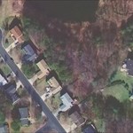
One phenomenon one should be aware of when examining aerial photos. The positional corrections used to make orthophotos use a digital elevation model that is keyed to the ground elevation, thus the tops of buildings or other man made tall objects are often displaced in position on the photo. So the only thing you can rely on is the location relative to the base of the building.
The color imagery on terraserver looks like it happens to be fairly vertical so that the displacement is small. It is pretty hard to tell what is what without seeing it on the ground, but it looks like there may be a relatively sizeable slab on the top of the particular structure and from the offsets given to the edge it appears to be reasonably sizeable.
From the shadows it looks like it could be on the same building as the large cross, which looks flat from the pictures I can find doing a random search of the net.
- jlw
I'll try a link:
Picture of my guess at the building
68-eldo,
I am thinking *I* am the one who jinxed me because I broke the cardinal rule of good luck--I mentioned it out loud. It was bound to happen, but to have gone three years and so many searches before it did made it hurt more than it should have. Still, I plan on getting to that mark. Since the "boss man" said if the NGS wanted to hunt for it they could, I may try to get permission on NGS letterhead saying they need to get a good recovery and I am the man. Carrying that letter in would be fun. I may also simply as at the top level of the Game Commission, not mentioning that I was turned down locally. Since I am sure the right arm doesn't know what the left arm is doing, or more likely, the left big toe, I may just get permission from "corporate" to look for it. Another fun visit for me!
-
FYI From NADCON:
NAD 83 datum values: 34 28 37.23529 81 31 10.71954
Versus the approx. N34 28 37.7 081 31 10.8 given. That's pretty close considering accuracy of the GPS and given as approximate.
The USGS description reads:
"Blairs, 7.0 mi (airline) NW of; 5.5 mi (airline) SE. of Whitmire; 46 ft N. of centerline of county rd. to Blair; at site of burned old brick house (Cudd Mansion); ub ground space that was once foot-walk to house; 6 ft N. and 20 ft E. of pronged chnaberry tree; 8 ft S. and 3 ft E. of large painted elm tree; in concrete post; standard tablet stamped TT 6 P 1934."
NAD 27 Position Latitude = 34d 28m 36.73s
Longitude = 81d 31m 11.35s
NGVD 29 elevation = 500.178 ft.
-
He is probably looking for HV4853 or something else close. Arlington, VA.
If so that is the actual spire of the church. What is called in intersection station. That is something which can be seen from a distance and therefore positioned by triangulation methods, but may not have been occupied or monumented.
See the datasheet.
Sometimes or even often the tower has changed, been destroyed or rebuilt and it may not be in the same place. The recovery note on the current NGS datasheet indicates it has changed nature, but I suspect it is at least in the the same position.
- jerry
-
While I have limited expertise in this, it is my understanding that in cases where there are changes in elevations or position of a large area such as subsidence and earthquakes. It usually requires new work to be done and the work re-levelled or re-adjusted based on new measurements at some point in time when it is recognized as becoming a problem. This has happened several times in southern California, and I believe in the New Orleans area. Elevations that may be in error in terns of an absolute value may usually still maintain relative consistency as well as to other features on the ground so that engineering still fits them. The big exception is things that deal with water, it still has to run downhill no matter what the benchmarks say.
So from a practical point of view if a large area subsides it doesn't aedversely affect use of the benchmark monuments and is sometimes corrected from time to time.
Horizontal movement is similar but different. If the pacific plate moves 1 foot relative to the rest of the continent, again all the boundaries, buildings, highways, fences and other survey monuments move with them. So you wouldn't want to have everyone's property lines and improvements fixed except relative to the ground. Local movements, landslides etc., are a different story.
- jlw
-
True North has become sort of a technical whipping boy recently in some forums. There are a group of surveyors who say it doesn't even exist.
I would say that you can define true north as being based upon the rotational axis of the earth and in that sense it is virtually identical to geodetic north. What differs in the historical context is what were the tools at hand to determine or 'measure' it. In the old days (Before 1983) it would have been almost certainly determined by an astronomic observation.
That astronomic observation will give a slightly different value for true north than our desired earths rotational axis because the local gravity vector isn't coincident with the perfect ellipsoid mathematics. If you had been able to bring in geodetic positions you could compute some of those differences. Now these values are well known and mapped, but it was not that easy to know those corrections prior to sometime after 1983. And in the very early days before you had any nearby geodetic control, for example in the process of a surveyor determining a boundary in early america based on a defined meridian, or based on a define true bearing, the astronomical method would have been the only way to go to determine 'true north'. In that sense in retracing such a line you have to keep in mind how it was determined.
The small difference between geodetic true north and astronomically determined true north (without correction) is usually pretty small, commonly less than a few seconds, and occasionally in a few locations up into the teens of seconds.
The north reference on the data sheets is geodetic true north, the geodetic programs will be in that same system, the only time you would need to worry about the laplace correction would be if you needed the azimuth very accurately and had determined it initially by means of an astronomic observation, which you would today be able to compute and correct to geodetic.
More confusion perhaps?
- j l w
I think that GeoCalc is a lot better program than NGS's FORWARD only because the makers of GeoCalc took the trouble to allow for various input and output formats so you don't have to convert anything or press buttons on your GPSr to get the right format.
Maybe DaveD can come in here and tell us the difference between "Geod. Az" and "true-North-based". I figure they are essentially the same. This would be that Geodetic North is the same place on Earth as True North. They are probably the same position as the Celestial North axis point. Magnetic North and Rotational North are other places on Earth, Rotational North being much closer to True North. (As I recall from long ago reading somewhere, Rotational North precesses about 8 feet around True North once a day or something.)
-
I received a reply from Deb this morning. She suspects the disk is a reset that wasn't reported to the NGS. She also said that she was going to send it to Burt Smith, who would make the determination on what to do with this mark. She asked him to contact me directly.
Anyone know who Burt Smith is?
Kent
Apparently one of the NGS personnel who deals with Mark recovery and maintenance at their headquarters.
Mark Recover B. Smithhttp://www.ngs.noaa.gov/INFO/OnePagers/Online_Mark_Recovery.pdf
- jlw
-
By the way, I am interested in knowing who UNK1 is.
Does anyone know?
That is a corner set in a cadastral survey (boundary survey) retracing section lines probably for the purpose of locating and marking national forest boundaries. From the marks it was set in 1983 and appears to be a standard BLM monument in use at that time frame, an aluminum post 2.5 ins. diam with an aluminum cap.
The marks indicate that it's designation is what is called a 1/16th 120 between sections 24 and 25 on an elongated set of sections in Township 11 North, Range 18 East of the Mount Diablo Meridian. This means that it is approximately 120 chains East of the 1/4 corner or a nominal 160 chains east of the SW corner of that section. Elongated sections like that are fairly rare, and ones elongated to that degree are very rare.
The monument would most probably have been set by BLM crews working out of their Carson City project office, which was administered from the California State Office BLM in Sacramento, which is the primary place you would go for the records of the survey in which the monument was set.
- jerry wahl
-
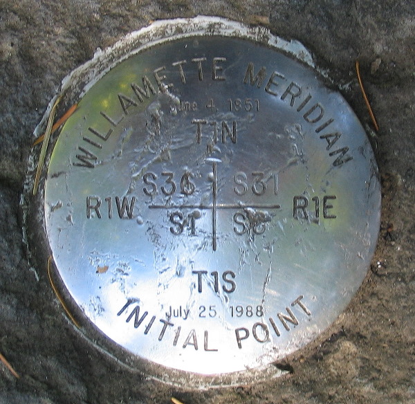
There is extensive documentation for the point as well as it's more recent history of destruction and resets in a book called "Initial Points of the Rectangular Survey System", by C. Albert White. This book may still be available from the Professional Land Surveyors of Colorado (PLSC) society.
That reference indicates that the stainless steel monument set in 1988 was placed in a drill hole in the remains of the stone which has been set in 1885 by the county surveyor to perpetuate the position and then locally referred to as 'the willamette stone". There is some confusion in that account because it states that the stone was "quarried grey limestone" and not granite. It has been vandalized a number of times.
I would bet that there may be articles in the local land surveyors society PLSO newsletters about the 1988 work.
There are also a number of pictures of both the 1988 and its predecessor brass tablet which had been set in the recently broken off 1885 stone in 1967.
- jerry wahl
PS. It would appear to me that the C&GS observations predate both the more recent cap remonumentations, but is on the same stone which is the one set in 1885. The elevation would differ since it has been broken off, and reformed several times to accomodate the current stainless steel cap, but I would expect the station to be substantially intact for horizontal control purposes.
- jl
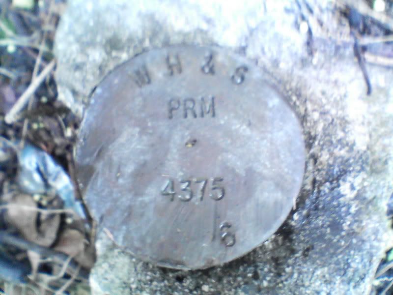
The disk is mounted on a block of granite and I would love to believe it is the remnant of the original granite stone, but without documentation, there is no geodetic control, so there is no station. A few questions:
1) From the look of the disk, is this a standard land survey mark or just an "ornamental" disk?
(click for full size)
2) If the state replaced the old station with this disk, would there be state records giving control information?
3) If the answer to the above is yes, is there anyway to get this to the NGS to update the datasheet?
4) Anyone know any details of this monument as relates to the preservartion of geodetic control?
Control or no control, it's a neat place to visit and well worth your while if you are in the area.
-
Looks like a private surveyors boundary monument. The initials are probably of the firm name, (Williams, Hatfield, & Stoner, Broward County) the lonely 6 at the bottom was possibly part of a date i.e. 2006, the number in the center the license registration number. That can probably be looked up on line.
I was out placing a cache and stumbled upon this marker about 3 inches from my final cache coordinates. I couldn't locate it in the database, maybe you guys can help.
Coordinates: N 26° 04.923 W 080° 09.655
Here is the lame camera phone image:
And here is a contrast enhanced version:
Any info would be appreciated, I have never logged a benchmark, but this was staring me in the face so I figured I snap the pic.
-
Although it is not always the case, the call for a large wooden stand left in place might mean some old weathered lumber laying around near the station.
It would probably have been worth while spending 15 minutes getting a good GPS fix first, but that is easy for me to say since I wasn't there.
The coordinate certainly doesn't 'seem' to fit being "..TOP OF THE
THIRD KNOLL ALONG THE TOP OF THE RIDGE FROM THE TRAIL LEADING UP THE MOUNTAIN.." though does it?
- jerry
-
I would suspect the number is something like a federal (or possibly state) highway project designation. I would not think it was stationing if it is cast into the cap, or someone would be casting a lot of custom caps.
jerry
In reference to the street, which way is the disk's arrow pointing?
-
It may be a BM, but is also likely to be a surveyed boundary marker. The coordinate would allow one to figure that out a little better.
- jlw
..did you happen to get the coords? There are thousands of benchmarks that aren't in the database that GC obtained from NGS, so you could have found one of them - If you have a pic you could upload so people here could take a look at any other add'l stamping, etc...
-
They say that they are "Right-of-Way" markers, so that means that they are survey boundary markers delineating the public right of way for the 'strip'. The Land Surveyor's number is on the bottom, if you want to contact someone and find out more.
- jlw
Those disks can be logged in the Recovered US Benchmarks Waymarking site.
I was thinking more along the lines of a catagory for just those 'fancy' marks along the "Strip".
John
-
Someone could probably start a special subcategory of recovering marks that have been submerged by reservoirs, etc. Scuba gear, skin diving, snorkels, glass bottomed buckets and boats. Definetly an opportunity for specialization on someones part.
- jlw
Benchmarking, not geocaching.
At best it would be a Not-Found. A submerged disk under a lake is nigh unto useless for a surveyor.
Good enough, thanks for the info, although I am pretty sure that I knew it was Benchmarking and not Geocaching and that the disc would be useless now underwater. I may be new to this forum and such, but I don't believe I was born yesterday. Just making sure I do things correctly.
-
Oops, Sorry for the mistake...
Here is the plat with your island and AMC
jlw:
Thanks for the clarification. The links you provided point to plats for T69N R19W, but the monument is for Sec 19, T69N R18W. Here is a link to the low res plat that shows Sec 19, T69N R18W:
http://www.lmic.state.mn.us/surveydata/stl...69r18w4fi01.pdf
The area of interest in on the left of the plat, a little below the middle of the sheet.
And here is the link to the high resolution zipped pdf of the same plat:
http://www.lmic.state.mn.us/surveydata/stl...69r18w4fi01.zip

questions about the process in 1944
in Benchmarking
Posted
I have been to many stations in the western states where the 4-foot stand (not really a tower), was still existing in the immediate area of the station. It is sometimes still roughly in place over the point, but has usually been set aside so that the station could be occupied by conventional surveying equipment on tripods, other sight targets, and/or GPS on tripods. In western mountain and desert areas wood materials often survive a long time.
- jlw