

jwahl
-
Posts
274 -
Joined
-
Last visited
Posts posted by jwahl
-
-
Note that there is a BM shown on the quads north of your coordinates. As you probably understood, your coordinates do not match your description and are down the hill on the east side.
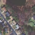
Here is a picture that I found:
BM/Sta on Jewell Hollow Overlook
The approx coordinate of the BM map mark from the USGS quad is 38 37.630, 78 20.337
jlw
PS: That picture appears to be from 2004 so the mark itself does not appeared destroyed unless it's setting has moved. Also Google Earth imagery shows white spots just E. and W. of this coordinate, either of which may be the "large rock". You might take a look and see what you remember and refine your coordinate.
Mitch, the location is 38 37.498 and 078 20.392, the marker is on top of a set of large rocks in what I remember as Jewell Hollow overlook (West side of the Skyline drive)
Joe
Hi Joe,
How about sending me an e-mail with ALL the info that you have. (including Dave D's notes)
Hate to waste a 120 mile round trip if I don't know exactly what I'm looking for.
~ Mitch ~
-
Question: It looks like from one sign in your pictures that the bridge may be dated 1940 but if the mark was set in 1934, then is it the same bridge? There are a lot of possibilities. For example what part of the bridge was done in 1940.
The next question is about what is the parapet wall versus a wing wall or abutment on this bridge?
This is one of those where a good elevation on the top of the wall might help verify. -jw
-
Maybe.. But you had a photo, so what specifically do you want verified? - jlw
I would like to ask a favor of a fellow benchmark hunter. As I reported a while back, I found a marker (from 1928) in the Shenandoah National park and from my photo and description Dave Doyle was able to find some old records that show it as lost or reported missing sometime back. I would like to see if someone could go to 38 37.498 and 078 20.392 to see if they can find and verify the location. As I remember it was just off of the Jewell Hollow Overlook parking lot to the south west and it was on top of a set of big rocks. It wasn't far from the parking area and it looked like lots of people walk around and over the rocks by the looks of the paths around the area. Let me know if you can help.
AUJOLI
Melbourne, FL
-
Before I try to look up Kidder's notes, I thought of another possibility. Whoever is describing these stations is perhaps confused. They are after all a C&GS control survey crew trying to describe a station and here is this other monument they are not necessarily all up on exactly what is supposed to be out there.
There are boundary monuments relating to attempts to establish the CO-NM line from several surveys. In particular Kidder preserves the position of some of the Carpenter monuments. (see preliminary information in the field notes provided in the thread from a year or two ago).
If those monuments were numbered in miles from the west (From 4 corners), it comes out to be very nearly 313 miles. So I am going to speculate that the monument referred to does not say TX on it at all, but is a Kidder remon of the Carpenter monument done in the course of his 1908 era retracement of the Darling line for the Supreme court.
I'll see if I can find the notes this weekend. The mystery will be hopefully more fully resolved when someone visits and takes a nice picture of the thing.
It doesn't fit well for mile 313 up the NM-TX boundary and it is not at this locatin by about 16 miles anyway.
- jerry
PS some more info as background
If that link doesn't come through because of the need for a password, perhaps I can cut and paste, but it is pretty lengthly case with a lot of the history.
-
As an another aside, the GL1451 says "Boundary Mi Cor 19+..." which is Approximate 19 miles from the extended line of the Texas / New Mexico border at the start of the Oklahoma panhandle. The Oklahoma panhandle is recessed from that line 2.2 miles. (Which, therefore, dosen't explain the "23.39" part of that name.
Usually that format which is a line distance or stationing format means 19 miles + 23.39 chains. Where we are talking about the Gunter's chain of 66 feet of which there are 80.00 in a mile. If this were along a railroad or highway the stationing would be in feet, but since I am relatively sure about the context of this survey this format is miles plus distance in chains. FYI
- jlw
-
I suspect the post 313 is essentially being used as an RM to the other station 1451 and were probably originally described on one station report and thus they have the same 'goto description'. It seems more confusing once they are separated into two data sheets. In 1451 it says
GL1451|---------------------------------------------------------------------|
GL1451| PID	Reference Object					 Distance	  Geod. Az  |
GL1451|														   dddmmss.s |
GL1451| CM9093 BOUNDARY MI COR 19 RM 1			  15.160 METERS 08039	 |
GL1451| CM9094 BOUNDARY MI COR 19 RM 2			  11.183 METERS 16237	 |
GL1451| GL1450 BOUNDARY MI COR 313 NM TX			 6.760 METERS 17951	  |
GL1451| CM9092 BOUNDARY MI COR 19 AZ MK						   3141519.0 |
GL1451|---------------------------------------------------------------------|
The TX part is also confusing, unless this whole thing is misplaced somehow. If I didn't know better from the marking described the one mark seems to be on the Colorado NM boundary at 23.39 chs west of mile marker 19, and the other is on a line coming up from the south being mile 313. There might be some history of an older survey that is being referenced. There were several attempts to run the texas line and this may be the remnants of one of them. Arthur D. Kidder was involved in investigations and the resurveys of both boundaries in the early 1900's. I think that the TX-NM line originally came all the way up to the colorado line before the cimarron strip was made part of Oklahoma.
I believe I have access to copies of the field notes of the Supreme Court CO-NM boundary survey, and perhaps it can shed some light, however it will have to wait for a few days for me to hunt them down and see what they describe.
Jerry
http://www.amerisurv.com/PDF/TheAmericanSu...ecember2006.pdf However this article describes a discrepency that is only 4 or so miles and not 16...
--------------------
Both paragraphs refer to "Boundary Post 313". Now, that tells me it's referring to "BOUNDARY MI COR 313 NM TX", GL1450. So someone referred to Marker 313 IN Marker 313's description? GL1450 also has no marker information (Disk?) or setting information (Rock? Cement post?) These two are on my hit list, and I'm curious what I'd find regardless. Thoughts?
Mike.
All fine and dandy. However, if you look at the name of GL1450, it has "New Mexico" and "Texas"., however, Texas is quite a ways to the east from here. That's not really the funky part tho. Atop from the fact they're right next to each other, the descriptions seem to have been cut and pasted. The "To Reach" directions are exactly the same, *AND*, both have the following nearly-identical paragraph:
Both paragraphs refer to "Boundary Post 313". Now, that tells me it's referring to "BOUNDARY MI COR 313 NM TX", GL1450. So someone referred to Marker 313 IN Marker 313's description? GL1450 also has no marker information (Disk?) or setting information (Rock? Cement post?) These two are on my hit list, and I'm curious what I'd find regardless. Thoughts?
Mike.
-
It looks like the newly formed "Midewin National Tallgrass Prairie", possibly related to base closure lands.
Bearing trees were taken at almost all of the original PLSS corners where trees were in existence at the time. The practice was to blaze and scribe marks on the blaze indicating location by a particular set of rules, usually indication section, township and range the tree was located in. The species, size and location from the corner of the tree was noted and reported in the GLO field notes of the surveys. In early surveys in the midwest these were also reported in a thing called the descriptive notes which were an abbreviated record and often placed on the back of the survey plats.
Much use has been made of these records in inventories of the types of trees that were native on the lands before they were settled and cleared. Doing a search for GLO and bearing trees will lead you to a lot of links.
Later surveyors used the trees to verify the locations of the section and 1/4 corners which were often monumented with only wood posts. Some later surveyors such as county surveyors would also use them and sometimes make new bearing trees. The term witness tree is another term usually meaning the same thing.
The USFS has always been pretty good about preserving and maintaining their corners and create a record called a corner card. They also have had a fairly agressive boundary maintenance program for the last 20 or so years where they hire surveyors to remark and post their lines. The signs you see are commonly used in that work. The bearing tree tag is used to call attention to the fact that a given tree is a record bearing tree and recites the bearing and distance to the corner that was found by whoever recovered the corner. There are also the township and section location tags we always called 'K-Tags' for some reason have been around since the early 1900's and are used also to mark the direction to a corner from a nearby trail or road.
It looks to me like the example given in Illinois is just using the tag as a reference instead of representing an actual bearing tree, but it is possible that there was a tree there at one time. Bearing trees dating from the 1830 or earlier original surveys have been found in the general Chicago area I am told.
To find the records that describe the bearing trees you will need to find the location of the GLO (General Land Office) field notes and plats for your area. Counties often have copies. In the west they are still held by the applicable Bureau of Land Management State Office. In the eastern PLSS states they are often in the custody of the state, but a duplicate copy was made and can be in either National Archives or in the BLM Eastern States Office.
Illinois has their records on line here: http://landplats.ilsos.net/FTP_Illinois.html
Eastern States has some of their plats on line here (but not Illinois): BLM ES Records
Examples of descriptive notes can be found on the Eastern States site in the Michigan records.
- jlw
CoyoteTrust,
Nice photos, but near Chicago, Illinois, is the last place I would expect to see US Forest Service land surveys taking place. Is there really any Forest Service land in that area?
CallawayMT
-
I haven't perused the listings, but past experience tells me that even if the tower is listed as a station, it is not uncommon to find a monumented mark under it set by someone that may still survive even if the tower does not. While that may be reported clearly on the NGS data sheet it might not be.
- jlw
-
On the magnetic declination question. Garmins and I suspect others have an internal model of the mag dec and so do "look up" the value for your area. This can usually be viewed on one the Garmin setup screens also. I have found it to usually be within a degree or so. You can check it with one of the online magdec calculators such as is found on the NGS web site.
- jlw
Magnetic declination around here is not that big of deal. Just a few degrees......that leads to another question....
If you set your GPS from "True North" to "Magnetic" are they internally programmed to compensate for varying degrees of declination? Like here in the this part of Bama declination adjustments are only a few degrees, but another state it would be off several degrees. Do GPS programmers account for this? I would guess so, but not totally sure.
Thanks.
-
The real operational method using is differential elevation differences, and so depends entirely on what controlling elevation you decide to use to 'calibrate' or set up on.
I do not have access to my equipment right now or else I could upload a few pictures and examples. As it is, it may be a few months before I get a chance.
- jlw
-
Thanks for the replies. Yes I think you could or should essentially establish you own set of temporary BM's near each search area. They could just be a level surface that you document in your own notes, or something marked. The differential barometric levelling could be run a few times to check or possibly refine values for the TBM's.
Since the zlog modules (about the size of a postage stamp), do record data, one could be left alone at a base location if it is safe, like in your back yard. The procedure in a run could include one or more existing BM's in the area, or on the same line as the ones you are searching for, and a TBM in your back yard could then be derived and then used for future work.
- jlw
-
Follow up to my first post.
GPS units such as Garmin's with built in digital altimeters could be good or bad. I have heard that there is a way they can be set so that the GPS reading is used to update the barometric altitude. If you knew how this worked it could be more accurate or more unpredictable.
Raw GPS elevation is just pretty sloppy, +-10-20 feet is about as good as I think you can reproducably get, but that is just my intuition based on my own experiments. I hear reports of very unhappy users of altitude enabled GPS units. But since I don't have one at present I cannot say. There might be a method to smooth (average over time) the two device readings and get a good result. Whether this is done on not I have no idea.
Knowing what elevation a 'candidate' mark is at can be useful. I think you probably see it here almost every day. If you know the metal plug on the bridge abutment is 2.5 feet lower than the BM you are searching for 1) you can start to discount it. 2) you can search at points higher and maybe find it.
Datum would ultimately also be an issue and if you do any type of leveling you need to be sure you are on the same Datum as the marks are published in.
I just think it is an interesting possibility, as yet unproven, that inexpensive technology may be available today to replace expensive analog devices costing $1000's of dollars in the barometric levelling area. This type of application would be moot for surveying applications since RTK or static GPS would be able to give accuracies to 1-2 cm, but for BM search applications it might be viable.
I am skeptical of the pressure/altitude conversion in the ZLog, and therefor would want to do testing if there were large variations of altitude between the base and target areas. For example 500-5000 feet for example.
Another concern is temperature compensation. Should the base be in the same temperature environment (outdoors) as the roving unit.
- jlw
-
I started to write something up on this about a year ago, but didn't post it. One thing as a surveyor, you learn is that knowing where you are vertically can be of assistance in finding a BM. I am talking about the vertical control BM's and not so much tri-stations or horizontal control points.
For example, if you know the height of the horizontal plane that the benchmark is supposed to be in, this provides a valuable additional dimension that can be useful in minimizing a search area. Well sometimes anyway. Examples I see are BM's along roads with steep banks or hilly roads, BM's on bridge abutments or other structures, etc.
The trouble is, or course, that you have to get closer to survey skills and work to establish that plane reasonably accurately. Sometimes just knowing within a foot or two can be useful, but even that level of accuracy is not trivial to obtain.
More advanced or dedicated amoung you might have already tried some of this, or acquired something like a rod and level. Those tools could be used in a number of ways to get a close elevation into a BM location. However since BM's are frequently spaced at some interval of distance, it might mean running a level line 1/4 to 1/2 mile or more. In some cases you might consider it though, just another extension of dedication to the search that some might enjoy trying. A homemade rod and hand level might work well enough in some cases.
However the idea I was playing with was barometric leveling. This used to be used for reconnaisance surveying for roads, etc. The equipment was pretty expensive still and consisted of a precise aneroid barometer/altimeter and a recording altimeter. The latter would be set as a fixed point and the former taken for a ride, intermediate points where elevations were desired would be read and recorded along with the time. The results of the roving altimeter would then be compared to the stationary one for the same time and a differential elevation or corrected elevation could be determined for the point.
That type of equipment is still available, and a lot of it comes up surplus also on Ebay. The company that made such equipment was named American Paulin.
What caught my thought process, though was if more modern and less expensive digital altimeters could be used in the same mode. I had acquired a hiking class digital altimeter for about $150 at REI and started testing it as a stand alone device. I have never had a GPS with a built in altimeter, and that would be another extensive topic of discussion as to viability and testing. In this case, it appears to me that it probably only has a usable accuracy of 1-2 meters, even though it can read out to even feet. Changes in location often show jumps of 2-3 feet which indicates to me a possible conversion from integer meters to feet, but it is hard to tell how the thing really works. I have used it to go from a known elevation point next to my driveway to a BM a mile or so away and be within a few feet.
What you start to see is that barometric pressure is in a constant state of flux so that even a few minutes of time the altitude set to a BM elevation can change significantly. By the time you travel off to some search area and get back you may have 10-30 feet difference. Now you will have to use some record keeping. There are two approaches I can postulate. One would be time based rate of change, so that you prorate the changes of pressure over the loop run based on time. That would be only as accurate as the assumption that the change in pressure was more or less linear change with time. The alternate would be to have two such devices and do the relative positions somehow.
The next step was to look for something akin to the recording altimeter for the fixed station. My search led me to an inexpenive module someone has been building for the model airplane and rocketry folks that can record altitimeter readings at user set intervals and records them in internal memory and can then be dumped to a PC file. The particular module I found was called ZLog. I acquired two of them and the device needed to interface to it. For use in this application it is a bit of a kluge, because you have to rig up a small battery pack for each module.
I have not tried this in BM applications, nor evaluated how well it works at this point, so I am just throwing out ideas and wondering if anyone else has been down this road at all.
So the way it would work, is that you would start up each module with an approximate or known elevation. Leave one, and take the other on a drive that encorporates maybe one known BM as a check and one point in the vicinity of your search location noting the time since it was started, or maybe several points can be occupied, then return to base. Download the data and do some differential computations.
The interesting thing about the ZLog is that it is very sensitve. If you set it on your desktop and initiate it, it will change to a foot lower after being lowered half a foot off the desk. Since it only reads out to the foot, that is about as good as you can get. I can't recall if the digital data is more accurate or not.
The next thing is that you notice even more how rapidly pressure changes and results in different altitude reading. Differential comparisons seem like the only way it could be accurate for correct elevation. Another factor that seems clear to me is that how far geographically you try to extend a level run would deteriorate the results the farther you go since weather fronts, etc. are not generally constant over a wide area. If you have a stable high or low, you might be able to go farther distances.
Just some thoughts for today.
- jerry wahl
-
In case people here may not know. Dave Doyle posted this notice to a surveyor board today.
NGS Database To Be Unavailable
Posted By Dave Doyle on 2/28/2008 at 4:16 PM
This message was just posted by the NGS database manager:
The NGS primary database server will be unavailable from Saturday evening, March 8 at 5:00pm, until Sunday evening, March 9 at 11:00pm (all times Eastern time), for quarterly security patching and the first stage of a major disk storage upgrade. Datasheets and most other data retrievals via the NGS website will be unavailable during this time period.
-
I have found that if you are stamping a cap on iron posts it is not uncommon for the die to bounce depending on the rigidity of the object it is resting on and give you multiple impressions. It can be very annoying. My memory may be incorrect, but my recollection is that was when you were working against a hard surface and it is possible that the pipe/cap itself recoiled. It probably wouldn't happen with a cap already set.
- jlw
FX - you mean stampingssssss, right?
Some practice on an old piece of metal would have been a good idea, in retrospect. I've got a set of stamps at work I'm going to borrow someday & play with.... probably won't do better on my first tries.
From seeing the other post about buying the stamps and such, I'm tempted now to get my own, just to play with.
 (Since, really, I shouldn't make fun of the stampingsssss, since I probably couldn't do any better.)
-
The general description to Baker ends up in credible locations for a trig station in several possible locations about a mile south of 'Jack'. One wonders if additional locations were scouted out, but never used, and somehow the descriptions got mixed up. Presumably the USGS quad depiction and the published coordinates are the correct ones, but until you find one of them, you won't know for sure.
I could give you my candidates for the Baker description if you want, but would try the published location first.
- jlw
-
My impression also is that there are a number of monument companies that supply surveyors and government, but that none of them go back a long ways. For example in BLM (Cadastral Survey), before 1980 or so, large contracts were let for monuments and that the suppliers were probably not currently existent vendors. I think one of the last big contracts was with some mom and pop organization in WA state(something like 3000 posts and caps).
After a long tradition of BLM monument materials testing and evaluation, BLM evolved to acquiring monuments in smaller quantities from commercial vendors which had emerged in the market for particular needs of the region and soils. We had problems with some soils, aluminum was tested for a while and found wanting in some places and fine in others. PVC was even tested. One of the better monuments found used a stainless steel pipe, and many of the more modern types created and tested for evaluation in that 1980's time frame were supplied by Bernsten. The company has provided some public information that was inaccurate about their role in that period, but that is another story I won't go into. BLM certainly does a lot of business with them and they provide a quality product.
- jlw
Regarding disc manufacturers:
One that I know of (and has been around a long time), and I think has done discs for NGS and other survey related US Gov't agencies is Berntsen.
Berntsen (a great company!) was founded in the early 70's I believe - I believe they do (did) the modern (NGS) ones - I'm most curious about the older USC&GS ones.. .I'm sure some of the companies may not be in busines any longer..
-
Meridian Stones have cropped up here several times in the past. And they have little to do with the Principal Meridians and Baselines established as the basis for the Public Land Surveys. In fact they are primarily found in older states where lands and land claimswere being surveyed (probably as late a1 1900) principally by the magnetic survey compass.
Do a search on the term "True Meridian" and your state. You may find that there is or has been legislation which provided for the establishment of meridians in local areas to assist the local surveyors. It was a really good idea, but it doesn't seem like they were used as much as one would like. Many of these laws are still in effect, although not used for maybe 100 years.
Given a set of posts established on the true astronomic north merdian, surveyors could come to the line, set up their survey compass and set off the proper magnetic declination so that their compass would read north when pointed north. The needle on the compass points along the lines of the earths magnetic field, which differ from true north. The difference which can be referred to as variation or declination varies with location and changes with time. A good survey compass had a provision to set off this value (some with a vernier) so that the reading on the compass (the needle points to corresponds to ) 0 or north when the compass is sighted north. At that setting all the bearings read from the compass will correspond closely with the 'true meridian', or astronomic north.
If all the surveyors in a county or small region set their compasses this way every year or so, then all the surveys they performed 1) would be on or close to a true and consistent basis of bearing, 2) would match each other and 3) would not be subject to WHEN they were done.
I think I posted on the topic, perhaps in the geocaching forum, a few years ago when one particular stone was found.
If I find my post, I will copy it up here.
- jerry wahl
-
As a surveyor by avocation, I have to admit that having people setting a lot of their own monuments around makes me a little nervous. Particularly the ones marked 'Survey Point'. Of if someone were to mark an elevation on one of the benchmark discs.
Please exercise some caution. Surveyor's as well as land owners sometimes mistake things that look like a survey monument as a corner of some property, and that can lead to a lot of unforseen mischief in future years.
- jerry wahl
-
Another option, get a PDA such as an ipaq, oziexplorer ce, or NG topo, and a bluetooth sensor. It would all cost about half, and no limit of images you could use.
I see not many noticed that the links I posted to the colorado topo's a few days back. It almost seems like a scam that people would buy a specific unit to load these maps which are commercially available for any Garmin map unit.
Perhaps it is a different source, but isn't it odd that only Colorado is available?
The other question that needs to be resolved is what level of detail. They are NOT DRG's of the 1:24K quads, so they will not look like them exactly. But, if they use the 1:24K DLG's and sort of fake in the contours as they explain, they should be pretty close to looking like the same thing.
There are a whole class of GPS units for mapping and GIS that allow loading images of your choice, and they are generally about double or more the cost of a consumer grade GPS unit.
- jlw
Patty:
You know, for the difference in price between the Delorme PN-20, you could buy a good used PC, and use it only for uploading the PN-20.
Er, or I could load Windows on my Mac. But I'm not interested in that sorry. :-)
Patty
-
I have pictures from one of these forums of several of those markers. They were either from here or the geocaching site. Since they were about 4 years ago, I suspect they are somewhere on the cacheing site.
I'll see what I can dig up on the history of the boundary survey.
j. wahl
Newbee here, but Several times over the years i have been on top of Talimena Drive outside Mena Arkansas and Talihena Oklahoma. I took a picture a long time back of a marker that stood about 5 foot tall that i believe had 6 sides or 8 sides, can't remember. It had Choc. 48, M. on one side and ARK. 1877 on the other side which was the arkansas side. I have tried to find it in benchmark searches and other places to no luck.
I am new at Geocaching, even so new i found my first one my mistake while looking over an old cemetery near the red river in Oklahoma, Brown Springs..... Check it out, its worth it.
I'd like to know more info on the state marker, as if there are any caches near it, history and stuff like that.
i do believe it is at
34 degree 41'38.2" n
94 degree 27'20.0" w
Not to sure if that is right as that is off of a map on flashearth.com
Soon to be into this alot more as soon as i can figure out which GPS to get.
LaterZ
Tony
ozone@sovwc.com
-
As a small note of caution. The triangle symbol on the stake or lath is common symbology for a control point, so I suspect it is not a corner but a surveyors traverse point set in the course of a boundary survey and NOT a corner of the property itself. The marks may be initials of the company or of the survey client. Likely the point on the ground may be a 60p nail.
Very commonly seen.
- jlw
Difficult Run is correct. And the stake appears to witness a piece of rebar that has been driven into the ground to mark the property line or corner. Very common.
Will
-
There were/are DLG's for quad maps, that represent the 1:24K planimetric features, and then 1:24K DEM's can probably be used to regenerate the contours. So then you have vector format maps.
That is something like what I expect has happened with the Colorado set. You don't have to buy a different Garmin to load them.
- jerry
Just got a Colorado email add from REI: HERE
$600?! And it doesn't offer real USGS Raster maps? (Yeah, yiou can import them using 3rd party.. but for $600, it had better come with them..)
I mean, I really like it, and if I ever won the lotto, I'd get one, but... whew. That's a lot of money.

-
The oblique view from the west clearly shows wires and poles. If the white square thing shown on the overhead in google earth is the building, then the 70 yards puts it about lined up with the southerly baseline of the tennis courts. Since it was demolished it shows up in some photos and not others.
In this view there is a pole at about that location.
It looks like you might have to rotate that view so you are looking west by doing one click on the counterclockwise icon.
If the building is not there adjust accordingly, to one pole up or back. The location also fits the coordinate latitude fairly well. If additional tracks were laid, even the poles could have moved. The 98 feet from the road would verify if they are about in the same place or not and seems to fit well from the photos.
- jlw
 (Since, really, I shouldn't make fun of the stampingsssss, since I probably couldn't do any better.)
Need help to verify a location in Shenandoah National park
in Benchmarking
Posted
Most USGS marks are not in the NGS database.