


Madproforg
-
Posts
84 -
Joined
-
Last visited
Posts posted by Madproforg
-
-
Just came across this http://www.magicshineuk.co.uk/products/Anti-theft-Tracker-GPS-GPSTRACKER which might be handy if your worried about your bike been stolen. A rear light with a GPS tracker built in, tempted myself to blow the money on one of these.
-
Glad to hear the bike was ok. I've gotten into the habit of always locking up, even for a quick pop into the newsagents.
Tire wise I like the Schawlbe Marathon Plus range (currently running the Marathon Plus ATB) for the puncture protection. with nearly 1500 miles on them haven't had a puncture yet. Even barb wire hasn't gotten through to the tube.
-
From your profile you appear to be UK based, are you using the OS Discoverer (1:50000) maps on the Oregon. In the UK section of the forums quite a few people are having issues with the 4.80 update with the OS Discoverer maps and cache icons.
There are only two possible solutions
1) Revert back down to the 4.50 firmware
2) -- this is not a good one at all -- don't the OS maps.
-
From the reviews I've read the Voice prompts require either the car mount, which has a built in speaker, or headphones.
The hints for caches are probably work the same as the Oregon, you must be navigating to the cache, then in the geocaching menu there is the option to display the hint.
-
The field you are looking for is Trip Distance - this shows how far you have travelled since resetting the Trip counters.
Tap on one of the displayed fields and a list appears, scroll down and you should spot it. Tap on it and it goes back to the screen.
Once you see the distance it shows either
1) just walk until it's gone up by 0.5 miles
or
2) setttings -> reset -> reset trip
then switch back to the display and walk until it read 0.5 miles
-

The entrance for Into The Mouth of Madness - wet, dark and noisy. A bit spooky when your on your own.
-
Generally the difference capacitive versus resistive.
There are pros and cons to both types.
capacitive - generally brighter, more readable in sunlight than resistive, but doesn't like working with gloves
resistive - works with gloves (or styles/stick/pen) but dimmer than capacitive
Handheld/outdoor units prefer the resistive to allow use with gloves - having to take gloves off to use the screen is possibly not what the customer wants especially when it is cold.
I can see the screen well enough on 550 (from before the 450 came out) and have use used the screen while wearing motorbike gloves - try that with an iPhone, it beats the screen on a Palm E3 which can be a real nightmare to read in bright light.
Mounting on my bicycles (mountain and road) I spent extra and got a RAM mount for my bicycles, allowed me to position the unit for best visibility, once set I normally don't have to bother adjusting it again until I switch the mount between the bikes.
-
I know the camera on the Oregon 550 automatically detects landscape/portrait mode, the only one it doesn't like is upside down.
Personally I thought the rotation was just part of the compass, it knows what angle the GPS is been held at, no need for an accelerometer.
-
Havn't use it much but here are the keys I figured out on an E63 - should be the same on E71
1/R - Zoom map in
2/T - Up
3/Y - Zoom map out
4/F - Left
5/G - cycle between screen modes
6/H - Right
8/B - Down
7/9/D-Pad - display list of caches
-
A good site for information on the Oregon is http://garminoregon.wikispaces.com/Miscellaneous, I learnt more about mine from here than from the manual.
The Miscellaneous section has a few tips to help with the screen visibility.
With the Oregons been touch screen, a screen protector is worthwhile investment. Glad I had one after riding down a wet dolomite cyclepath, the front wheel kicked up rather a lot of muck so everything got splattered.
-
For the handlebar mount I prefer the RAM, swaps between the two bicycles (a mountain and a road) quickly and allows position adjustment. Downside is it cost quite a more.
Maps I switch between Openmtbmap (http://openmtbmap.org) and Velomap (http://velomap.org), they use the same data as maps from Talky Toaster, just processed in a way to optimise them for bicycle use. They also have an installation option to optimise the display a bit on the Oregon - more white background which can help in sunlight readability.
Openmtbmap is aimed at more mountain bikes, while Velomap is aimed at the road bike.
The routing on these, especially openmtbmap, can seem a bit strange. They hate major roads with a passion, I've seen it do a 6mile route to avoid a 200ft trip down A road. Not much a problem for me as I always just treated them as guide, especially after seeing one sat nav get a little confused and keep saying do a U-turn no matter the direction of travel down one stretch of road - it got turned off (for a hour) and the paper map came out.
-
The best software for the Nokia in the UK is probably Viewranger, which uses will download the OS Landranger or Explorer maps.
The software itself is fairly inexpensive, but the cost starts adding up depending on how large a map you go for.
It does import gpx files so can import geocaches.
-
Here is what I have on the phone
SmartGPX http://www.smartcaching.de/smartgpx.html for cache management, will create garmin style fieldnotes for upload to Geocaching.com.
SmartGPX has an addon that will also export the coordinates to a Landmark for use by
Nokia/Ovi maps & the built in GPS Data app - this does stop navigating once you are close.
Mobile Java apps - these don't access the Landmarks
Geocaching Live - will import a gpx file, or download using 3g. Maps displayed are OpenStreetMap downloaded on the go. There is a Java application to complement this which will download the maps for offline use.
TrekBuddy - not strictly a GeoCaching app but it will does read gpx files. Maps have to be created using another application on a desktop (mobile atlas creator is a good one for this)
-
This is from a S60v3 phone while the 5530 is an S60v5, but at least should point you in the right direction.
Tools -> Settings -> General -> Positioning -> Positioning methods -- in here on an E63 I can toggle a "Bluetooth GPS" option on and off
-
My normal method is to click the Install button under the installed map list on the right.
When the dialog box appears click the ... button to the right of TDB file and select the tdb file in the img folder
Then do the same for the Overview map (generally named the same as the tdb file) & the TYP files (this might not exist)
Final step before clicking the INSTALL button is to enter a name in the Registry Name box
I believe that cgpsmapper is only needed if the img file has been compiled for direct placement on the gps so doesn't have the overview & tdb files.
In this case I use the gmaptool to extract the seperate img tiles from the compiled img file, which also calls cgpsmapper to covert a created mp file into the overview map.
P.S. as you might be able to tell I'm not the best at documentation:rolleyes:
-
awesome info thanks line 41 take me to ..if (LatLon) { ?

is it in MARKERS? MAP CREATION? ADD CONTROLS ? LAYERS? or way before,cant seam to find the text

Sounds like it might be a different version of the script. If you look at the top for @description there should be a version number, the one I'm using says v1.3.4
If yours says something earlier it's probably worthwhile downloading the latest version first - http://ge.pythonmoo.co.uk/gcmap/geocachingmaps.user.js - thanks to "Follow the arrow" for the link
-
If your on windows 2k or later
In the Format menu make sure word wrap is turned off (no tick besides it - selecting it will toggle it on and off)
this enables the Goto option in the Edit menu, (shortcut is Ctrl-G I believe) which allows jumping to a line number
I had discovered this feature in notepad by accident one day, and ended up puzzled for a bit as to why it didn't work all the time.
-
The maps move ok for me, it is showing a pointer to the cache and I've edited my previous post to add in the edit required to enable the additional waypoints.
I've also flipped between the different map types and all seem to be working.
-
Edgemaster made it a lot easier to figure by having comments in the code.
I'm still on v3 (usng an extension that is no longer active that doesn't work in 4). Can't see any reason for it not to work with 4, it's just adjusting the html in the page which should be the same across both.
-
The incentive that now means I ride the 13 miles to work then 23 to get back home while cachg. A year and half ago I hadn't been on a bike for 20 years.
-
Found a temporary fix to get it working with the new site - not extensively tested and as long as you don't mind using a text editor to change one line.
Right click on the Greasemonkey icon and select "Manage User Scripts"
In the list that appears select the Geocaching Map Sub and then click the edit button
Your text editor should then open (notepad probably - mine has been changed to a different one)
find line 41 which says
mapDivId = "ctl00_ContentBody_uxlrgMap";
change this to read
mapDivId = "uxlrgMap";
find line 87 which says (this is for the additional waypoints)
coord = parsecoords(awptblr[j].cells[5].innerHTML);
change this to read
coord = parsecoords(awptblr[j].cells[6].innerHTML);
Save.
For me that has brought back the OS maps on the cache page.
Edit - added in a change to enable the additional waypoints
-
Unfortunately the GUI version appears to be Windows only.

-
There is a way to do this, it does mean using the command line.
download the Mac version of gmt from http://www.anpo.republika.pl/download.html and extract it
run it like
gmt -w -m "NEW DISPLAY NAME" imgfilename.img
then copy it the GPS as before.
-
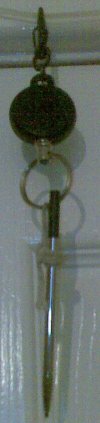
If your afraid of losing a stylus try this. Tie it to a heavy duty retractable key chain (thin steel cable rather than just nylon). Clips on the rucksack, pull to use, just let go when finished.


Latest biking report
in United Kingdom and Ireland
Posted
They are not exactly cheap, for someone like drsolly it might be worth a look due to the value of his bike and the time spent modifying it. Mine is probably border line at about 3 times the price the tracker, excluding the small modifications.