

NickPick
-
Posts
1117 -
Joined
-
Last visited
Posts posted by NickPick
-
-
I would imagine that that would be OK, but if you wait a while, ther'll be a moderator along in a minute to give you a definite answer.
-
Rivers are always tricky aren't they?
Looking up those co-ords shows it to be on the south side (although the river is only 3 pixels wide on my screen).
It's always difficult when you haven't looked up the location on streetmap beforehand.
One thing that might have helped is that the cache description mentions the Thames Path. The map shows this on the south side, so it might have been signposted as such on the ground.
On the subject of maps being wrong, one problem for cartographers has always been (technical term here) "generalisation". for example, on a 1:50000 map, a 0.5mm pencil line will be 25 metres wide, so to draw a road so that you can see it on the map, it has to be about 37m wide, wheras in reality, they're usually about 5m. This is not usually such a problem, but where there are parallel roads, rivers or footpaths, they have to be drawn further apart to maintain clarity for the reader, they're therefore not on the map in the same place as they are in reality.
-
Hmm. If a dog can be a travel bug... and a car can be a travel bug... can a girlfriend be a travel bug?
No reason why not, but she might have a couple of problems with it:
They're called "Dog Tags" - no girl likes to be called a dog!
The tags are made of aluminium, not exactly the most exotic of materials, although you could probably get Tiffanys to knock you up a diamond encrusted platinum tag for her.
-
Grabbing a TB from the current holder (who might be on their way home to log it) means that the TB's log doesn't get the mileage to that cache added to it.
I suppose that if you do take a TB from a cache which hasn't been logged in, grabbing it from the current holder, loggin it into the cache, then out again would keep it's mileage up to date, and save you having to wait for them to log it.
It might annoy the person you've grabbed it off, as they might feel that you're a bit impatient. I'd tend to wait a few days to give them a chance to log it, then log it myself, but everyone plays it differently I suppose.
-
There does seem to be a difference with this cache, as from the description, the cache placers are saying that for every visitor, they (the placers) will donate £1.
I can see that saying "You must donate money when visiting this cache" is wrong, but they're not charging cachers, they're making the donation themselves.
-
Another cute trick is to stop by your local "1 hour photo" place. Disposable cameras contain AA batteries... and they are still 3/4ths charged when they take them out of the camera. Sometimes they will give you dozens of used batteries if you ask nicely.
I got a whole largish bag full for free about a year ago and I'm still working thru the supply!

If you're taking apart your disposable camera, just watch out that you don't touch the terminals on the flash capacitor (usually black and about the size of an AA battery). I did once and it made me jump a bit!
-
Select NiMH. I think it's to do with the remaining battery life icon. Alkaline batteries start at 1.5 volts, and gradually slope down to lower voltage as they lose charge. Re-chargeables have a flatter slope, with a steeper drop off once they get towards empty. Knowing which sort you've got installed lets the unit more accurately predict how much time you've got left before they fail.
-
You should get one of these!
Hmm, as I look out of my window to see the snow laden sky, I think to myself "Solar powered? probably won't be charging much today then!"
-
I expect so. AA batteries are the same spec all over the world, so I expect the NiMH rechargeables are too. It's the input voltage to the charger that's different between the US and UK, but since you say you're using a UK charger, I think you'll be fine.
Have a nice time in Scotland.
-
Before we open the whole PalmOS / Pocket PC debate, I'll add by tuppenceworth:
I'd say that any palm will do fine for storing cache descriptions in cachemate.
The bettery life on the older palms is phenomenal. My old palm3 lasts for a month on 2 aaa batteries. I'm not sure about the battery life on the rechargable versions like the V / Vx, but I think it's comparable.
The other advantage to buying an old one is that if you lose / break it in the field, it's cheap to replace compared to a new shiny pda phone with built in gps, bluetooth and wifi.
I'd also recommend reading the guide to paperless caching by markandlynn, link here, which is a nice guide to it, and tempts me to buy a premium membership just as soon as there's $30 in my paypal account!
Hope my opinion helps.
NickPick
-
the 3 that are currently on ebay for 99p (buy-it-now) + £3 p&p means that the total is £3.99. I don't think that this is a bad total price (fingertech price is £4.25 plus standard £5 postage).
The reason for charging 99p and loading the postage is to reduce the sellers ebay fees, which are a percentage of the selling price, but not including the postage. Whether this is scrupulous or not depends on your point of view.
-
200mhz. I can beat that. My home PC is a 133mhz! Luckily for me, I can also use my work PC and internet though!
-
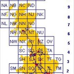
in streetmap, you need to put in the co-ords in x,y format. It's expecting a 12 fig grid reference, ie metres from datum. The Etrex gives a 10fig GR, and the two letters tell you what 100km grid square you're in.
to convert naffita's exaple, you need to know that TF is the square that's 500km east, 300km north. so add a 5 to the front of 57056, and a 3 to the front of 60799. this gives you 557056,360799, which streetmap puts on a headland just south of Skegness.
I've got a little bitmap of the grids, which I can email you if you want a copy.
Nick
-
Just a quick thought. Has anyone concerned about mickydicky's logging pattern actually contacted him to ask why he's logging caches like these? It may be a perfectly reasonable and innocent reason.
-
No caches within 50 miles. Now that's what I call bad planning!

-
Well, I hope they were using one, as they turned up at the car park in different cars, and had a head start up the hill for the time it too kme to but my boots on.
-
Eeewww. At least all the condoms I've found in caches up to now have been unused...
I found a couple using one about 15m away from a cache the other day. I didn't quite stumble over them whilst following the arrow, but nearly did!
-
I'm a bit concerned about you whinging about the feel of the paper considering where you read it!!!
Don't think I'll borrow your copy Paul.

Hmmm, I was thinking of borrowing it from the library once SP has returned it, but now you mention it..
-
You can get the î on a normal keyboard by holding down the Alt key, and typing 140 on the keypad (not on the numbers across the top).
thanks to the ascii lookup tables at this site
-
CORKY END FIG
CORN DYKE FIG
CRY FED GIN OK
ICKY NERD FOG
ICKY DOG FERN
guess who's not going to do much work today then!
-
I agree that it is a valid point, and I hate to see what used to be a nice green bridleway turned into sludge. But I can also see that there should be places where people can use their recreational 4x4s.
-
Didn't we do the whole 4x4 / horse / walking pole who does the most damage to the countryside thing a couple of weeks ago?
Having said that, I think using a 4x4 takes all the fun out of driving as close as possible to your objective (says the man who once tried to cross a 2' deep ford in a standard vauxhall astra - only got 1/4 the way across!)
-
he;lo
-
I just had the exact same problem (although a different dearing/distance)
I solved it by marking the current location, then walking until the arrow says 168 feet, bearing 248 degrees (your 68 plus 180, if your bearing is larger than 180, take away 180)
I've also just emailed Garmin to ask them this question, and I hope they'll add the required precision in future (and it's years since the yellow etrex had a firmware upgrade)
Hope this helps,
Nick

Newbie On Wrong Side Of River
in United Kingdom and Ireland
Posted
I think the reason for that might be that the county boundary crosses the road at an angle, it crosses each verge at a different place along the road, and since the sign is on the left for oncoming traffic, they're in different places along the road.
Either that or the councils concerned don't know what they're doing!
I usually know where the boundary from Buckinghamshire into Oxfordshire is by the sudden appearance of potholes!