


duncanhoyle
-
Posts
211 -
Joined
-
Last visited
Posts posted by duncanhoyle
-
-
Loads of good ones to choose from.
Top of the list has to be the Spar Cave - http://coord.info/GC347RC Don't forget a good torch!
With spar cave does the tide go all the way out or does water stay in the cave at a reduced depth do you know?
Andy
As far as I'm aware the water doesn't get into the cave itself. The inlet is part covered and you'd be cut off but the actual cave stays dry.
Bear Grylls did a show on Skye in the last couple of years and they spent a night there.
-
Loads of good ones to choose from.
Top of the list has to be the Spar Cave - http://coord.info/GC347RC Don't forget a good torch!
There a couple of good 5/5s in caves - http://coord.info/GC4MX3R and http://coord.info/GC4MX3C. We didn't find the 2nd one but had a good go at it - very strenuous.
There are lots of good earth caches including http://coord.info/GC48GVQ
Unfortunately we didn't have time to do any of the mountains or more remote caches.
If you want a fun day out then get a boat trip from Elgol and head to Canna. We saw porpoises and dolphins and had a couple of good views of sea eagles near Rum. There's a single cache on the island in a great location - http://coord.info/GC2XYH9
-
To people who regularly comment about changes to their stats from changes to cache d/t ratings - just see it as a reason to go out and find another cache. That is, after all, the reason that we're all here and doing this hobby :-)
-
I've just had my second such log in 30 minutes and I know of other people who are getting them. This time from http://www.geocaching.com/profile/?guid=b903de55-7aed-43b8-a79a-e99a8f0d1d56
Also an unvalidated user who signed up today and has 100 finds in many countires.
If this continues I'll be wasting more time checking logs.
Groundspeak needs to tackle this ASAP
-
I've just had a fake log with a spam link attached. user was http://www.geocaching.com/profile/?guid=7ff48eca-4ee1-4574-9318-8c30790cb714
An unvalidated account. Why let someone use the system without allowing them to verify? It obviously won't remove the problem completely but it might help.
-
-
Take a look here..https://www.facebook.com/groups/1649448581936494/
Those are the maps which I hinted about in my previous post. For anyone who doesn't use Facebook or who doesn't want to join the group here's the direct link to the Google drive. Full instructions are at that link.
If you have any problems please join the Facebook group (signing up to Facebook if required).
The maps contain all the Right of Way data from http://www.rowmaps.com/, covering most of England and Wales. Footpaths/bridleways and some tracks are also included from OpenStreetMaps
-
Can anybody recommend an online source of maps that show the majority of footpaths? OS 1:10000 show major footpaths but is woefully inadequate for the minor ones. I've just completed a Worcestershire series that uses some really obscure paths, marked on the ground with waypoints, that don't occur on any map I've been able to find online. Downloadables for a Garmin would be the icing on the cake but I think it's a big ask for this level of data to be readily available.
Just out of interest, I'm surprised that a scale as detailed as 1:10000 doesn't show all the defined rights of way. Checking the local area, the 1:25000 map seems to have no less detail than the definitive map (of which a version is available via http://www.rowmaps.com/). Any idea why some would be missed off by the OS? I'd have thought that the OS would be supplied by the County Council with details.
It's a shame that not all councils and local authorities provide digital ROW data or even have online maps accessible. Last time I looked Cumbria had an online version but nothing to download and previously refused a freedom of information request for their data (requested by the rowmaps owner). Tyne and Wear doesn't even have an online version.
Hopefully soon there'll be a new set of maps released which show all the ROW from the rowmaps site and paths etc from OpenStreetmap - on Garmin, Android (cgeo + more) and hopefully iOs. It just needs a few more tweaks...
-
By the way - your link worked fine for me, although I had to delete the trailing . - https://www.google.com/lochp
-
Thankyou so much for that link. I've signed the petition and also given feedback on their forum and through the maps, although I'm sure they'll just ignore it and assume that we're all wrong
-
A colleague mentioned that a smartphone biking app which used to have OS map support has suddenly stopped as well.
Still no luck getting my OS maps back in GME despite logging out, clearing cache, trying other browsers.
I've also noticed that the GME link to MAGIC Maps leads to a map which shows 'SSSI Impact Risk Zones' rather than SSSIs
-
Thanks, but that didn't work in either Waterfox (my usual browser), Firefox or Chrome.
You probably need to clear your browser cache.
-
-
- What do you like most about challenge caches?
They help me focus my caching and help me to decide where to go on caching trips rather than just focusing on numbers, uninteresting series and micros. Without challenge caches making things interesting I may well have given up a couple of years ago. I still rarely cache but when I do it's generally to qualify for challenges (either actual challenge caches or just personal challenges).
- What do you not like about challenge caches?
They need their own cache type rather than being lumped in with Unknowns/Mystery. Ones that require a lot of traveling. However, I can happily ignore these.
- What would you like to see changed about challenge caches?
Own type, possible own attributes (eg. must be completed in a day etc)
- If you could describe your favorite challenge cache type, what would it be?
Ones that make you think about your caching style. Not necessarily making you change it but make you think about how you cache and why. Looking back through past finds is good for this as it helps you remember the good ones and makes you realise how many pointless caches you did before you realised that there was a better way!
- What types of challenge caches do you avoid?
Find x number in a day. Yes, I've found and logged some but I didn't intentionally set out to qualify for them.
Ones that require long trips or visiting lots of different areas of the country. If I qualify then great but I don't intentionally go on long trips to do so (fuel is expensive).
-
-
Thanks for the work on this. I'd already attempted to get it working using a personal key for Bing but had no success. Using your settings and my own key I can get some OS tiles to display but not at every zoom level and not all areas - they appear at 1km and 2km zoom but no where else. Even at these zoom levels a lot of tiles are missing. The same happens on the cache page and the main map.
I have had OS maps working for a few days, testing out my method to see if there were any pitfalls. So far, so good. Follow these steps to see if you can get it working also.
1) Go to Bing Maps Key and follow the instructions there to get a personal key. I got a "Basic" key as a "Trial" key only lasts 90 days. I think a Basic key gives you 50000 tiles per day but I can't be sure. If there is a usage limit, best not to share your key with anyone else.
2) Insert your key into the following string, replacing the 'xx...xx' bit.
{"alt":"Ordnance Survey by Bing","tileUrl":"https://t{s}.ssl.ak.tiles.virtualearth.net/tiles/r{q}.png?g=3440&productSet=mmOS&key=xxxxxxxxxxxxxxxxxxxxxxxxxxxxxxxxxxxxxxxxxxxxxxxxxxxxxxxxxxxxxxxx", "subdomains": "0123", "minZoom":10, "maxZoom": 17, "attribution":"Ordnance Survey imagery from <a href='https://www.bing.com/maps/'>Bing Maps</a>", "name":"osbing"}3) Add the above (revised) string into GME as a Custom Map source, both http (cache page) and https (big map).
4) Select OS maps from the drop down as your preferred map source.
-
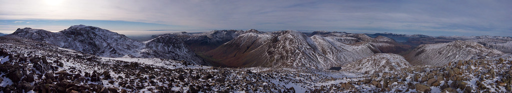
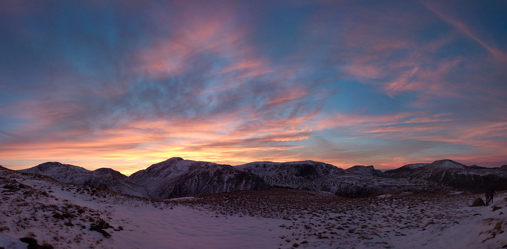
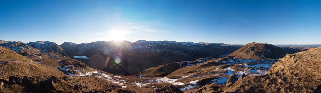
A few from me from a few weeks ago in the Lakes. Not sure how many I'm allowed so here are the best 3
Great End Panorama Taken from very close to this cache
Glaramara sunset
on the descent down from the summit and this cache
The sunset was so stunning that we couldn't stop taking photos and ended up with an extra hour of walking, ending in the dark by head torch
I had found those 2 previously
Angle Tarn Pikes
taken about 2m from this cache
This was a great sunset with no wind, warm sun and no one else around.
-
Thanks for the link and enthusiasm for old hides.
I mention, gently, that I'd rather see an old cache archived under the original ownership than adopted. This is what saves the original history, as adoption does not. I think this viewpoint is often lost.
Sometimes I have to agree. There's a 2001 cache near me that went missing, was archived and then soon after unarchived and adopted. It was replaced and went missing again, replaced and went missing. There land owner obvious didn't want people there as there was a log with comments of trespass and threats of police action. The hide was moved about 70m so that is was on a footpath. It went missing without being found. Clearly land owner issues! The cache was replaced with a nano hidden in a small log

Yes, when you find it you get a smiley for an old cache listing but it's not the original cache in any form. I was going to say that at least the original cache page has been retained but sadly it hasn't.
-
New ones will never be allowed. The problem with them is that the new coordinates don't go through the review process so they can get placed anywhere, including all the areas where caches aren't allowed (eg in the UK - military areas, schools etc).
it would be good if people stopped placing comments on the cache page of that particular travelling cache. It's putting undue pressure on the CO and cache pages are not places for discussion.
-
I wrote myself a GSAK macro for doing this but these days I pretty much only use ProjectGC as linked to by patdhill. It sometimes seems to miss out the odd one that would help fill the next round of my grid but it's usually reliable.
It analysis your finds, shows you your current grid, lists the caches which will complete you current grid and shows you them on a clickable map.
The only thing missing is a way to limit it to the closest one for each d/t combination (unless they've implemented that since I suggested it to them).
-
It's on my cv. Partly because it demonstrates various general skills but mainly because navigation, GPS use and surveying is sometimes part of the job. I've also created caches on nature reserves which include educational material - something that quite a few outdoor organisations would benefit from.
-
Either way, please be aware if you're in this area.
Aware of what? Paranoid walkers who are going to report you to the police.
There are a couple of caches near those caves.
-
The nearest active cache to the one active one on the island is 7.6 miles southeast (on a neighbouring island)
All the other caches that were on this island are showing as archived - most were by the same cache owner and were archived last month.
That's a shame - I noticed the caches one our trip to Skye last year and a boat trip to Canna suggested that Rum would be an interesting place to cache and bothy.
However, I notice that the cache owner is based in Germany and hasn't really done much caching recently so I suspect that the containers are actually still in place - you can always go and find them and log your finds. If they've been removed then you'll still have had an enjoyable trip to Rum.
-
GCF0 (oldest cache in UK) has the original logbook and container
When I visited that cache in 2012 the log only had a few pages left. This log - http://coord.info/GLAPP6W5 mentions removing the original (because it was soaked) and says that they'll contact the owner to get it back to them. I doubt this happened as the owner hasn't logged into the site since 2004, hasn't logged any finds and has just this one hide.
I forgot to add a link to the old one I found - http://coord.info/GC132F in Reivers Revenge on the Scottish/English border
Also forgot to say - it was still in good condition (except for a little mould on the cover) and wasn't even 1/4 the way through.
A nice idea. I heard that was the plan for the log book removed from Scotland's First (GCF0) and the log was going to be taken to a Mega. Anyone know if this happened or has the log ended up in a pile of rubbish on a cacher's desk?
-
Hi Ray
If you can make it to one of our local meets you should get the chance to check out quite a few different units. The next event is on the 16th in Heddon (http://coord.info/GC5H0ZD). We were there in September and it was a good turnout of over 25 (25 attended logs but quite a few of those are teams of 2 or more). I think a few people there have Etrexes and there'll be plenty of other model around as well. Most of us will have a few different phone apps if you want to get help with them.
If you want to chat with North East cachers there's our forum at http://www.negeocaching.co.uk/. It doesn't get much traffic but a few of us prefer it, particularly for writing trip reports.
There's also a few Facebook groups if that's you thing - https://www.facebook.com/groups/munkeh/ if the North East one.
Duncan (from Heaton)
-
I found a couple a few years back that had identical coordinates but one (a mystery) was placed in a tunnel below the other. Directions to find it were in the first cache and you needed to drive 2.5km and walk another 1km to get to the location. They were placed in 2010 and were great fun.
Moratorium update
in General geocaching topics
Posted
At least we have Challenge caches back, and the option to get checkers written or write them ourselves - better than several alternatives that I wouldn't have been surprised if GS had implemented them.
A couple of issues, some of which others have mentioned:
Checkers aren't infallible. Someone took it upon themselves to write one for one of my challenges. A couple of times I've run it it failed. Mostly it works though.
I don't think there's any way in the API to get the date of logs before your own when you find a cache so there will be no more Resuscitator caches. There are already several out there so that probably isn't too much of an issue, but it does remove one avenue for potentially interesting challenges.
Lots of challenge checkers simply say if a user has qualified or not. I would request that checkers provide a list to the user of how they qualified. This would let the challenge owner check if they so wished. Part of the appeal of challenges for me is find interesting caches that I may want to visit myself - I have a Remote/Lonely challenge because I like those type of caches and qualifying logs suggest caches which I might like to visit myself. I have a Resuscitator challenge because forgotten caches are often more challenging or in remote locations and, again, qualifying logs suggest future caches trips for me.
One final point - Challenge caches really need their own icon so they can be differentiated on the map.