


Gonzo-YT
-
Posts
207 -
Joined
-
Last visited
Posts posted by Gonzo-YT
-
-
I have begun putting together some information and resources on caching in the Yukon. Add it to your bookmarks, I'll be adding more information as I go.
-
That is a hilarious idea for travel bugs, do it!
Easiest thing might be to mail one to another cacher far from you, and then start them both on the same day. I am sure lots of people (including me) in this forum would be willing to help out.
-
"If you place it, they will come..."

-
I have an Emtac Trine that I used with my Palm. It is a great unit -- super accuracy, good bluetooth connections. Get the custom otterbox case and it's totally waterproof to take with you in the field.
The datalogger function is nice as well. I have strapped it on the dog's harness before on walks, and then when I get home I compare his track with mine.
The battery life is excellent, many times longer than your PDA is ever going to last. If you get the right cable, you can charge/run both your PDA and your GPS from the car socket.
Finally, you can attach an external antenna which may or may not be an important decision for you vs. the CF card. Using it inside a vehicle or in very cold temperatures might make you want something that can have an antenna.
My biggest problem was that none of the Palm-based software was very good -- Fugawi was awful and PathAway was decent, but the biggest problem is using bitmapped maps. They're too big, don't scale and don't carry any information (ie. place names, elevations, routing...).
So, I bought a dedicated GPSr instead. I have semi-permanently installed the Trine in my vehicle, and just basically use it there. I still take the Palm out in its otterbox to use CacheMate.
Regards,
Anthony
-
I have heard that Energizer Lithium batteries work well in winter. They are rated as low as -40 C. Of course, they are also hideously expensive, but they claim up to 3x the battery life in your GPS unit.
The problem is, below -20 C the screen is no good. Some people I know up here keep the GPS tucked inside and wear an external antenna outside.
Of course, for geocaching, you can always keep the unit tucked away and warm until you get to the cache site.
-
I'll echo that... I'm located too far north to reliably pick up the WAAS satellite, as it sits really far down on the horizon.
The other day I was out with my Etrex Vista C and a Garmin 72. The 72 was able to pick up WAAS, while my unit wasn't. Both units were showing 4-5 meter accuracy, and their coordinates were always within 1-2 m of each other. I used both for a search-and-rescue GPS exercise and got identical performance.
I checked my Vista against a surveyors mark the other day, and after taking an average position for about 90 seconds was within 1-3 meters on all coordinates -- easting, northing, and elevation.
Besides, who are we kidding? We aren't surveyors here, we don't need cm-level accuracy. If your GPS can get you within a 10m x 10m square, then you should be able to find the cache.
Regards,
Anthony
-
Re: Shared uses....
It's part of life up here in the Yukon that lots of people do lots of stuff outdoors, both motorized and not. We're spoiled, really. Within a 50km radius of anywhere there are always tons of trails and old roads to explore. Many of them aren't even mapped.
The really sad thing is that, with all this space and so few people, we still have constant conflict between users.
Any activity -- hiking, biking, snowmobiles, ATVs, hunting, fishing, geocaching... -- doesn't have to harm the land if done responsibly. Certainly there are trails or areas where you want to limit or encourage certain uses, but I think that ecological considerations aren't really the big issue.
I find conflicts tend to be based more on people. There is no reason that shared use can't be successful, if people are responsible to the land and courteous to each other.
Unfortunately, up here people tend to adopt an "us vs. them" attitude that doesn't help matters. We've had people throwing punches on trails up here this year.
We also have the problem where people think that "goddamnit, this is the Yukon. We have tons of land and I have the right to go anywhere I want and do anything I want, and you can't stop me."
I really wish people would stop talking about their rights, and start thinking about their responsibilities. If we all looked at it as a shared responsibility, it would help people get along better.
For example, the Klondike Snowmobile Association maintains hundreds of kilometers of the Trans-Canada Trail network up here that EVERYONE gets to use. It works great. I've had lots of people pass me on snowmobiles while I am skiing and they always slow down and wave or nod.
That's really all it comes down to. The person who whips by at 100 km/h and endangers lives, the people who construct homemade barriers on trails, the people who cut down trees to get around those barriers.... sigh....
This all leads to conflict, and then you get well-meaning people trying to come in and legislate a solution. Really, the solution is just all about people getting along and recognizing their obligations to the land and to future generations.
Regards,
Anthony
-
This makes me a little uneasy, especially after having just come back from an amazing trip into Gatineau a few weeks ago. Last time I did the trip on a rented mountain bike. Maybe next time I'll be forced to rent a car, since they apparently want to limit mountain biking. It might help conserve the park, but it isn't helping the environment or my wallet.
At any rate, we'll see what happens. I really hope it turns out well, Gatineau is now one of my favorite places to visit -- and to cache!
While I'm on topic, perhaps some locals can give me tips on planning my next trips.
I will be there in the last week of November. Will there be snow for cross-country skiing, or should I plan for another cycling trip? I need a non-motorized way to cover ground in the park.
Coming back again in February, I'm sure the skiing will be great then. I've just got to figure out where/how to rent skis. Can you take public transit to any rental locations?
Thanks for any info,
Regards,
Anthony
-
I almost found this Mobile Coin Collection bug, but couldn't find the cache it was in.
-
My $.02, after much trial and error:
CacheMate. I just recently tried CacheMate and it's great -- already sent in my registration fee. I just use the software that comes with it to convert the GPX file.
I also use GPS Babel to convert the GPX file into Fugawi format. I use Fugawi to map the waypoints and also to transfer to my GPS.
Of course, I also need to get waypoints and tracks in and out of Garmin Mapsource from time to time. GPS Babel to the rescue again.
Sigh... And this is the EASIEST way I've found so far. Some day, all applications will just natively support GPX.
Bottom line: Cachemate is well worth it.
Regards,
Anthony
-
Cool... That makes a lot more sense than having to know the tracking number. Will do.
Thanks,
Anthony
-
I just placed a bug into a cache. While I was out doing it, I took some photos with the bug to add to its page. However, once I got back to log, I found out that without the tracking number (which I hadn't written down) I couldn't do anything but dump the bug into the cache.
I genuinely wanted this bug to "pick up a story," but unfortunately I couldn't do anything without the number.
Is there some way to add a log the bug that I didn't notice? I guess the best thing to do is in the future write down the tracking number somewhere.
Regards,
Anthony
-
1) ligher color or more natural color tent
Minor point here... A brightly colored tent is much better from a survival / search and rescue perspective. If you ever get stuck out there, you want people to be able to find you. Go for the bright red instead of the leafy green color.
-
Actually, this has already started me on a more ambitious project to document the history of these benchmarks.
The NOAA History site is just amazing. I found some old photos taken during that year and was able to find out that this expedition in 1943 was under the command of Lt. Cmdr (later Captain) John Bowie.
Through the NOAA and hopefully our own local archives, I hope to get some more information about that year. It will give me some work to do until spring, when I can go out and try to track down more of his survey monuments.
-
I'm really keen on finding some of these old US C&GS benchmarks. To me, they are a really fascinating piece of the history of the old Alaska highway. They're also a really fun challenge to look for.

While a few have been re-used and incorporated into the Canadian system, many of them aren't listed. The NGS database shows them, but there are no datasheets on-line.
Is it possible that there are paper data sheets on file somewhere for these? Is there an agency to contact for copies?
I also plan on talking to some of the surveyors around town to see if they have any leads.
Here are some examples that I pulled from the NGS database:
TT3910 A 60 43 14. /135 02 57.
TT3919 A 1 60 40 22. /135 02 26.
TT3914 AIRPORT ASTRO 60 41 49. /135 03 24.
TT3915 AIRPORT ASTRO RM 1 60 42 01. /135 03 45.
TT3916 AIRPORT ASTRO RM 2 60 42 01. /135 03 46.
TT3909 B 60 42 50. /135 04 55.
TT3918 B 1 60 40 50. /135 02 06.
TT3911 BEACON (CTS) 60 42 50. /135 03 38.
TT3908 C 60 43 24. /135 04 58.
TT3920 C 1 60 39 34. /135 01 59.
TT3907 D 60 44 22. /135 06 10.
TT3921 D 1 60 38 44. /135 00 20.
TT3906 E 60 44 36. /135 07 14.
TT3941 E 1 60 38 02. /134 59 49.
TT3912 F 60 42 47. /135 03 42.
TT3942 F 1 60 37 16. /134 59 39.
TT3905 G 60 44 48. /135 08 31.
TT3943 G 1 60 36 27. /134 58 55.
TT3958 H 60 45 42. /135 08 15.
TT3944 H 1 60 35 49. /134 57 55.
TT3945 J 1 60 35 04. /134 56 55.
TT3946 K 1 60 34 36. /134 55 36.
TT3947 L 1 60 33 45. /134 55 38.
TT3948 M 1 60 32 42. /134 55 27.
TT3949 P 7 R 60 32 10. /134 55 04.
TY8051 WHITEHORSE 7284 60 42 40.4/135 04 37.4
DE6615 WHITEHORSE CORS ARP 60 45 01.8/135 13 19.5
DE6616 WHITEHORSE CORS L1 PHASE CENTE 60 45 01.8/135 13 19.5
DE6617 WHITEHORSE CORS MON. 60 45 01.8/135 13 19.5
TT3917 Z 60 41 39. /135 02 41.
-
Love the new wording, I think it will make a big difference.
-
I found an old NGS benchmark last night. Not one of the ones I was originally looking for, however. This one is located quite close to the Alaska highway, within the city limits of Whitehorse, Yukon. This particular monument is used by the Canadian Gravity Standardization Network so I had newer data on where to find it.
Based on coordinates and information this one is TT3907. The monument just reads D/1943, as far as I can tell, but hard to say -- it's pretty banged up.
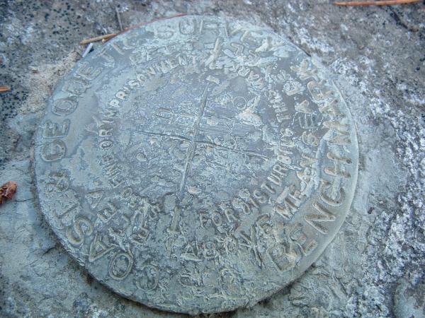
More photos and information are available in this geocache log.
I plan on going out tonight to try to find three old NGS benchmarks along the old White Pass train route.
Regards,
Anthony
-
I'm not really talking so much about the goal thing. If you're serious about it meeting a goal, I understand why you'd want to attach a sheet.
The point I'm getting at is, the way the tags are worded now, they don't say that you can't just keep a travel bug. You shouldn't need to attach a sheet to explain that a person can't just take the thing and keep it -- the tag should do that.
Agreed, there are many other reasons that these things are taken and go missing. But having such an ambiguously worded tag sure isn't helping matters.
-
Re: Matches in a cache.
When I place a remote cache, I put a small survival kit inside (not a trade item). One of the items it includes are wooden, strike-anywhere matches inside a waterproof container.
I do this for two reasons. One, there is a very remote chance that the kit will help someone who is in trouble. Two, I try to educate people a little bit. The kit includes a note that basically says "Out here, if you aren't carrying this kind of stuff, you should be" and also includes a few basic survival pointers.
-
This is of course, only my own opinion, but I suspect that a lot of bugs go missing with newbie cachers because of the tags themselves. Quite frankly, if I don't know what a travel bug is or does, reading the little tag won't help me know anything about it or what to do with it.
"I go from place to place, picking up stories along the way. Visit www.Groundspeak.com to learn more about me and add your own!"
This little bit of cutesy-wootsy text doesn't say what needs to be said. Nowhere does it tell me that I can't keep this item, or that I need to log it and move it on. Hell, it doesn't even suggest that I need to be left in a geocache. "I go from place to place..." -- does this mean I could leave a TB in a coffee shop, like a bookcrossing book?
The message needs to be more clear, something like:
If you take me, you must log your find on-line at www.geocaching.com. You can't keep me! Please place me in another geocache as soon as you can. Check the website to learn my goal and try to move me in the right direction, but above all keep me traveling!
-
Yeah, well that is the catch here. They are listed in the NGS database but they have no datasheet with them. Here is an example datasheet from the Canadian database, I believe it is for US PID TT-3920.
GSD LONG Report
Thu Sep 23 12:01:42 EDT 2004
Station 1 of 1
***************************************************
SITE IDENTIFICATION
Unique Number : 43Y024
Name : C-1-1943
Established By : United States Survey Agencies (National Geodetic Survey And
Province : YT
Prov. Identifier : None
NTS Map No : 105D11
STATION COORDINATES
Method : Scaled
Latitude : N60° 39' 36"
Longitude : W135° 01' 59"
Agency : Geodetic Survey Division - NRCan
UTM : Zone = 8 N = 6724918 m E = 498196 m
VERTICAL DATA
Vertical Datum : CGVD28
Elevation : 724.128 m
Order : First Order
Method : Differential
Adjustment Line : VA192
Published Year : 1948
STATION MARKER INFORMATION AND LOCATION
Marker Type : Permanent Agency Marker
Inspected in : 1943
Status : Good
Inspection Comments : None
WHITEHORSE
WHITE PASS AND YUKON RAILWAY, CONCRETE MONUMENT, 20 CM SQUARE, ABOUT 7.6 KM SOUTH OF STATION, 32 M NORTH OF MILE POST NO. 106, APPROXIMATELY 320 M SOUTHEAST ALONG OLD ABANDONED RAILWAY RIGHT-OF-WAY, FROM A GRAVEL ROAD- CROSSING, 18 M SOUTHEAST OF TELEPHONE POLE NO. 3388 AND 6.4 M EAST OF CENTRE LINE OF OLD RIGHT-OF-WAY, TABLET IN TOP OF MONUMENT, ABOUT 6 CM ABOVE GROUND LEVEL. NOT TIED-IN IN 1983. ESTABLISHED BY U.S. COAST AND GEODETIC SURVEY.
HISTORICAL COORDINATES NOTE: Coordinates listed below are no longer maintained by GSD.
None
PROJECTS IDENTIFIERS:
60135 VA192
As you can see, it hasn't been found or verified since 1943.
Seems like kind of an interesting project -- trying to relocate some of the history of the Alaska highway through these benchmarks.
I was out last night looking for this one, placed near the old White Pass and Yukon Route railway from Skagway. No luck at all. The coords were off -- maybe a problem with wrong datum -- and most of the landmarks they refer to are no longer in existence. I'll be back out tonight.

-
Both the Canadian and US databases include United States NGS benchmarks that are physically located in Canada. In my case, there are a number in my immediate area -- all from around 1943, presumably from when they were building the Alaska highway.
Is it an oversight that none of these appear in the Geocaching.com database? Is there any way they can be added?
For examples, look at PIDs TT3918-21.
-
-
A pier is generally a large wooden, concrete or metal structure, no? I imagine it has tons of nooks and crannies. Why does it have to be a virtual? Why can't you hide a cache there?
Bluetooth Gps Receiver
in GPS technology and devices
Posted
I recommend the Emtac Trine. It has the advantage of being able to connect simultaneously to four devices, so you could use it with the laptop and iPaq at the same time if you wanted.
It isn't all that common to buy in North America, but I got mine at Transplant GPS.
Regards,
Anthony