


Gonzo-YT
-
Posts
207 -
Joined
-
Last visited
Posts posted by Gonzo-YT
-
-
Save your money, buy a decent mountain bike!
-
The problem isn't just trails getting there, it's the sometimes-intensive search techniques. I've been to areas where people have torn apart logs, flattened large areas of bushes or grass, moved stuff around... Sure, it grows back but it looks like hell, which is kind of the main thing when you're trying to go for the whole "leave no trace" thing. Maybe you need to have a mandatory hint or spoiler pciture that will make sure people aren't tearing up the bushes looking for that little box.
-
I'll add this to the thread. I was just talking to a friend of mine who bought a 60C and cracked the screen the first day. (Lucky for him, Visa will cover the repair cost). He sent it in to Raytech in July, and he has heard nothing since. They still can't tell him how much it will cost to repair.
-
The screen eats most of your batteries, especially when the backlight is on, and the GPS is next. The compass uses almost zilch.
In fact, Brunton used to make a GPS/compass unit that got hundreds of hours out of the batteries, if you only used the electronic compass and pressure altimiter, turning the GPS on only infrequently (every 1-2 hours) for position checks.
I would give up the topo maps and color screen on my Vista C before I would give up the electronic compass and pressure altimiter. The latter are much more useful, IMHO.
Regards,
Anthony
-
The way I see it, the SUV issue is a bit of a red herring. I think the real problem is that people drive too much, no matter what they're driving.
I'm not saying stop driving around, as I know that isn't an option for most people, myself included. But, there are always ways to drive less. Walk places, use a bike in good weather, plan your driving so that you can combine things into one trip, share rides with people, that sort of thing. Try to use your vehicle three days a week instead of five, even that makes a difference.
Regards,
Anthony
If you're curious where I stand, I've got a 1986 Subaru wagon that has seen its share of fire roads, cat trails and the like.
-
You don't necessarily need to work with gc.com. Someone could design a logo, upload it, and be selling stickers -- along with T-shirts, hats, whatever -- later today on sites like CafePress.com. (No affiliation, never used it, just an example).
Regards,
Anthony
-
Up here, we're paying $1.20 / litre, which is close to $5 a US gallon. That's not too far off what we would normally pay, in the range of $4 a US gallon. Quite frankly, I think that the spike in gas prices is a good thing. Hopefully, it will be a bit of a shock that encourages people to think about ways drive less and find other ways to get around.
I hate the idea of driving to geocache or benchmark hunt, because the whole reason I like the activity is to get out on the land. I always try to walk or bike all or at least partway, or I do it when I'm traveling into the area for some other reason.
Regards,
Anthony
-
I actually have found my altimiter useful for finding benchmarks. The ones I have been looking for have scaled coordinates, and if they even have a description at all, too often all of the reference points are missing. If I am lucky I have one landmark like an old roadbed or something.
The one thing I know I can count on is an accurate elevation, so my altimiter can give me clues about where to search. I've also been able to find at least one by walking a contour line on my GPS map screen.
Regards,
Anthony
-
The pressure altimiter is far more accurate than GPS elevation, even with a good sattelite fix. However, the downside of the pressure altimiter is it needs to be calibrated regularly, as changes in atmospheric pressure due to weather will change the readings over time.
Auto calibrate means that it will calibrate the pressure altimiter using the GPS reading -- not terribly precise, in other words. However, it is still a good feature, as although your exact elevation might not be spot-on, your elevation gains, losses and plot over time will be very accurate using the altimiter.
If you have a known elevation, you should always calibarate manually from that. That's where your closest benchmark comes in very handy.
Regards,
Anthony
-
Once calibrated, I find that my Vista C is just about bang on. It's always within a few meters. Of course, weather conditions can have an effect.
-
Icefield discovery has only been found once since 2001, and that was by non-cachers in 2003. Without a couple of weeks, or access to a helicopter, this one is pretty tough to get to.
-
I think you guys are getting really wound up over nothing, as far as the CBC story goes. Take it from me, thousands of Canadians aren't tossing and turning tonight wondering how to keep those awful geocachers from destroying out natural heritage.
It's only a game, after all.
Regards,
Anthony
-
Canada-US border monument, located beside the Klondike Highway in the White Pass between Skagway, AK and Yukon.
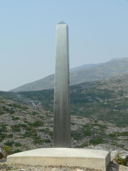
This photo doesn't show it, but the left and right sides are stamped US and Canada, respectively. Concrete is stamped:
118A
2000
-
In hindsight, I wouldn't have bought the Garmin Topo Canada, and in fact I might not have bought a mapping GPS at all. I just don't use it, as I use computer and paper-based maps. When actually navigating, I don't use the map display much, and that also makes the lovely colour screen kind of useless.
I think I should have bought something like the Brunton Multi-Navigator -- that they appear to have discontinued -- as I find I get a suprising amount of utility out of the electronic compass and pressure altimiter in my Vista C, more so than the maps.
But I'm also talking about using the GPS for a variety of navigation, searching and outdoor purposes.
For geocaching, you only need the most basic of GPS units. Between the description and free mapping services like Google, you can pinpoint exactly where the cache is and how to get there before you even start.
In fact, I used Google Earth to find a cache recently. It's great for ones that pop up at work when you don't have a GPS.

-
In a recently-published photography guide, I read that many larger cities actually require photographers using tripods to get a permit beforehand. I have no idea why this would be the case, maybe a liability issue -- I don't think it is terrorism-related.
-
I wrote the following letter to Parks Canada, and also recieved a forthcoming and thoughtful reply. I post my own letter here, although not the reply as I did not ask to do so.
Regards,
Anthony
My letter follows:
I'm a resident of Whitehorse, Yukon. I have been geocaching for just
over a year now, and I participate in a lot of other outdoor
activities. I'd like to give my view of geocaching in our national
parks.
To begin with, I agree that geocaching as an unregulated activity is
not appropriate in a national park. I think that the concerns you have
listed there are valid, particularly since geocachers represent a wide
range of people, with a wide range of awareness, knowledge and ethics
about natural areas.
However, I also firmly believe that geocaching is not inherently bad,
any more so than other acceptable park uses such as hiking,
mountain-biking or fishing. It all comes down to people following the
rules, and practicing respect for the land and the environment.
I think with the right combination of policy, education, and
enforcement some form of geocaching would not only have little
negative impact, but also encourage more Canadians to use national
parks. I think a lot of geocachers are people who typically wouldn't
go out and spend the day in a national park otherwise.
My main concern with the draft policy is that virtual caches are lame.
Lame, lame, lame. I'd rather not see any caches at all than just
virtuals. If I want to find a historical monument or natural feature,
I'll use a guidebook or a trail map and not bother with the whole
geocaching thing.
To me, you need to be able to sign into a logbook when you've found a
cache. That's the cool part about it, sitting out in the middle of
nowhere are reading the logs from people who found the cache 2-3 years
ago. As the sport lives on, the cache logbooks will help form part of
the history of the park, something like the climber's logs in the
Sierra mountains which are known to have entries from 50-80 years ago.
I think you need to find a way to allow physical caches with logbooks.
Maybe they need to be in pre-approved containers at pre-approved
on-trail locations, hidden in a pre-approved manner. Somehow, you need
to find a way to allow this to happen.
You could also ban trade items, if you concerned about what might get
left. Leave the onus to the cache owner to keep the cache "clean." The
one thing I can tell you about the geocaching community is that most
of us are very responsible people who take the guidelines seriously,
and often take it upon ourselves to correct a problem with a cache or
bring it to the attention of the cache owner.
I know that other jurisdictions have come up with some kind of
workable process for this, sometimes requiring a written permit before
placing a geocache. I think with the right approach, geocaching is a
great activity that benefits parks and park users.
Good luck with the policy, I look forward to seeing it.
-
Hi All,
Once again, I seek the collective wisdom of the group. So far, I've learned the difference between triangulation and leveling, first and second-order, height and elevation and all kinds of other cool stuff.
One thing I can't track down, what is the difference between a first-order baseline and other first-order triangulation?
The USC&GS annual report for 1943 refers to 110 miles of first-order triangulation, and two first-order base lines at Carcross and across the Takhini River.
Regards,
Anthony
-
Well, we aren't an organized group here in the Yukon, but there are now 8-10 of us and I know everyone
 . I maintain a basic Yukon geocaching site.
Regards,
Anthony
-
Thanks for the answers. Interesting question -- why would the NGS have established a CORS in Canada? It doesn't show up on their website, so I wonder if the site is still operating, sitting there derelict, or totally gone? I'm heading up there sometime for a geocache, so maybe I'll see what I can find.
-
Hi everyone,
First off, thanks to everyone for all the interest in my Alaska Highway benchmarks project. I'm hoping you can help me out. I have found NGS listings (no datasheets available) for three things in the same location:
WHITEHORSE CORS ARP
WHITEHORSE CORS L1 PHASE CENTER
WHITEHORSE CORS MON.
PIDs are DE6615 - 6617.
Based solely on the PIDs and descriptions, can anyone hazard a guess as to what this might be? It's located on top of a prominent hill near town, but a fair distance from the geodetic survey network along the highway.
Also, all the 1943 USC&GS discs I have been looking for have PIDS that start with TT. Does DE mean anything different? Could it have been placed at another time, or by another agency? I'm keen to go looking, but it's a 6km hike up that hill.
Regards,
Anthony
-
Although I am sure many others have done this already, I've manged to use the new Google Maps API to make an interactive map that can read geocaching.com LOC files. See it in action on my Yukon geocaches page.
Anyone is free to use the code. You will need to sign up for your own key to use the service on your site, mine won't work for you. The "caches.xml" file is in geocaching.com LOC format, replace it with your own.
If you want to be nice, you can credit me with a link to my site but I really don't care either way.
Regards,
Anthony
-
I try only to log traditional caches. The only virtuals I look for are the ones within my "closest" list -- now all found -- and the First Post series. The other types don't really interest me much. I need to know where the cache is located, because for me the fun part is looking up the location on a map and planning a route to get there.
Beyond that, my favorite caches are those that take a whole day, if possible. I like 4-5 terrain caches the best.
I hate the idea of driving to a cache. I'll bike or walk from some distance away just to make it more interesting. When I'm traveling I really enjoy caching on public transit as well.
I also find busy urban caches really uncomfortable. When I travel, I try to be selective about my caching because I hate feeling suspicious about what I am doing. The great thing is, our cities always have large green spaces, river valleys and so forth that give me lots of opportunities to cache in the city and not feel like a weirdo.

Regards,
Anthony
-
I was so dissapointed in Fugawi 3, I won't even deign to try version 4. I'll grudgingly admit that the desktop software was passable -- not good, but passable. However the Palm application was completely unusable, and was the main reason I had bought it. I switched to Ozi, something I should have done anyways since it is much better and everyone else up here uses it. No one here has even heard of Fugawi, and with good reason.
In fact, my original Fugawi 3 CDs are sitting in a cache I've had ready to place for a few months. Anyone who wants to save some bucks on v4 just has to make a little trip up north to be FTF.

Regards,
Anthony
-
A rather unfortunate sign from a 1943 USC&GS benchmark located near the Alaska Highway near Whitehorse, Yukon, Canada.

 . I maintain a basic

Parks Canada
in Canada
Posted
FYI, the Parks Canada mandate:
I'll leave the interpretation to others.
Regards,
Anthony