


Texas-Jacksons
-
Posts
102 -
Joined
-
Last visited
Posts posted by Texas-Jacksons
-
-
I hope this question hasn't already been asked. I didn't find any search results, but then again I'm not very good at searching this forum.
In addition to the open and closed treasure chest symbol, has Groundspeak ever considered creating a 3rd geocache waypoint symbol to symbolize caches that you OWN. I currently just manually change them to FOUND, but it would be very convenient to have a designated symbol for the pocket querries as well as to keep geocaches seperate in my 60CSX geocache menu.
-
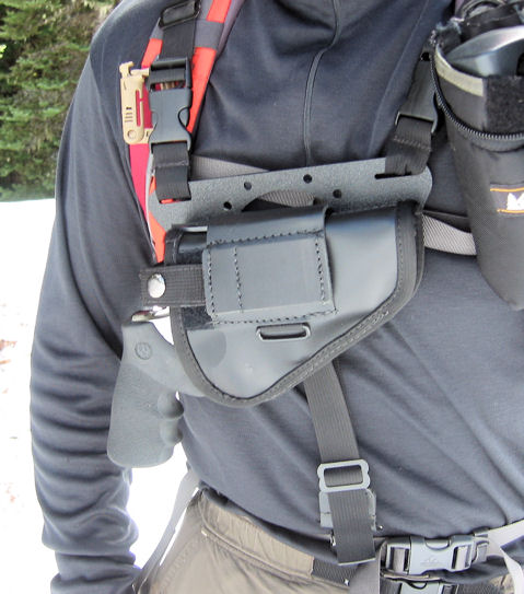
I'd like to know where I can find a chest holster similar to Criminals. I've been looking for one to fit my Colt Mustang and will attach to the shoulder straps of my Kelty Backcountry...
Chest holster in the woods:
-
I'm hoping to add a new catagory for Coin Shops.
If you like the idea and would be interested in becoming an Officer, please join the group and drop me a note.
Click Here:
-
I recently noticed that cache logs under "My Logs" as displayed on "My Account Details" page lists the logs in descending order of the date. However, caches posted in a single day are listed in ascending order. To keep my logs in the order in which I found the cache I have been submitting the last log first and first log last. This keeps my logs in descending order on My Account Details.
I wanted to point this out to see if there is a way to change this setting. Changing logs which are posted on the same date to display in descending order and thus keeping all of the logs in descending order as when they were posted.
Thanks and I look forward to hearing your thought on this.
-
FYI: I came across this story online and had to pass the word on:
Geocache scavenger hunt in Tahoe
"More than $10,000 in prizes will be inside some 50 caches in a treasure hunt for the most advanced player to the very novice".
"The popularity of the gizmo game will be showcased at Lake Tahoe's south shore June 17-18, a kickoff for summertime activities. The Lake Tahoe Visitors Authority has purchased 200 of the devices for the event, known as the World's Best Free Geocaching Prize Event In History".
-
I'm seeing this in your signature line:
Geocaching - The most fun you can have with $12 billion in military hardwareIs that what you're looking for?
Or was there something else?
YES!!! That's it. Why am I not seeing it? Looking for a setting somewhere that possibly turns off signautres??
Edit: Found the setting in "My Controls" under "Board Settings"
Thanks for the help.
-
Just text. Nothing extra.
-
(btw: I'm going to post this and that signature is going to finally show up - mark my words)
Or not....
.
-
I'm quoting this post because the topic was closed and I'm also having the same problem.
The difference is that I did click the "Register" link. Serveral time in fact. I have also logged out of the forums and logged out of geocaching.com and logged back in to both. I actually only use the forum link on the geocaching.com site to access the forums.
So now what?
(btw: I'm going to post this and that signature is going to finally show up - mark my words)
I've put some text in my Profile page, but it doesn't show up. I see this bit of advice:
Important! If you make any changes to your profile and they do not update in the forums, click on the "Register" link on the forums page and it will send you to a page to update those settings.
Problem is, I don't see a "register" link anywhere!
Thanks for any hints...
Paul
-
To serch along a route.....
Download a number of pocket queries based on zip codes along your route. You can find the zip codes here: usps.com. Get 300 or so caches for each zip code - don't worry about the fact that they overlap. Save all the pocket queries in one folder. Open GSAK and open the entire folder of caches. Just drag the folder onto the GSAK icon and then when it starts up check the box to load a folder of queries. The caches will all load into a single database and the overlapping caches will not be duplicated. Now you will end up with a ton of caches in your database. Don't worry.
Open Mapsource and create your route and save it somewhere that you can find it easily. Then use File, Export and export it as a .mps file. Go back to GSAK and Click on Search and then on Filter. Click on the Arc/Poly tab. Tick the spot for filter type to make it arc/line and then set the distance to something like .5 or 1.5 miles. Select Load From File and point it to the .mps file you exported (your mapsource route). Apply the filter and it will select ONLY the caches that are within your set distance from the road you will be traveling.
This is absolutely my favorite method on a road trip. Great explanation! When I run my pocket queries I also like to filter cache types that I don't want to include. On a road trip I usually avoid the virtuals and puzzle caches because I don't always have all of the info I need to find them. Once I've exported the filtered caches into a .GPX file and load them into my GPS I also load that same file into my PDA. Or just bring my laptop along which has GSAK.
-
what is the name of your geocaching organization?
TEXOMA GEOCACHERS
what is your website? (if you have one)
http://groups.yahoo.com/group/texomageocachers/
where are you?
WICHITA FALLS TEXAS, LAWTON OKLAHOMA and SUROUNDING THE RED RIVER
when did the group form?
JANUARY 2006
-
I'd like to share some facts & opinions regarding caches brought to the event, especially to those who didn't attend GW4.
The event was enormous! There was so much going on, so many people and such a large state park. This was only my second camping event and I felt a little overwhelmed when I first arrived at registration. There was a bulletin board at the entrance of the pavilion and I stopped to read it. On it were a dozen lat/longs posted with cache names. I wrote down the coordinates and went back to my campsite. My thoughts? “Wow, I didn’t know people were bringing caches. What a neat way to invite others to your campsite and identify yourself as a geocacher.” Note: Geocachers did not get to camp together in a single area. We were spread out across the entire park. I’d like to invite people to view the park map to get an idea of how spread out the area actually was. In the evenings the Texas-Jacksons sought out these temporary caches and met a lot of great folks in the processes. Why bring an actual cache rather than making a temp for the event only? Because some of these containers were really clever and it was a lot of fun to see & share creativity of a cache I most likely would not get to see otherwise. I’m not about the numbers so I have already deleted my logs. I’m content with knowing I found them and had a lot of fun doing it. Owners probably should have temporarily disabled their caches for the event, but I strongly disapprove of the archiving of these owners’ caches as punishment for showing off their creativity and socializing!
-
I agree with all points except this one.
DISAGREE(2) Claiming a Find on a cache carried to an Event for logging not at orig. coords, such as the Iraq cache (cheating)
Hey, someone posted coordinates. I hiked the trail and have the chiggers to show for it. What difference does it make where the original coordinates are?
On the other point: STATS
I like the stats. They help me distinguish those who do it for the love of the game from those who do it for the numbers. Someone logs my cache with only a couple of finds I like to welcome them to the game and to my town. Someone with a lot of finds I usually like to swap stories with. Someone with an obscene amount of finds I think to myself, each to their own - whatever makes you happy.
This politically correct, equalization of everyone only catapults people up and while dragging others down. If you don't like stats just ignore them. If you remove them than the superiority scale will only shift to something else. Then you'll have to remove that too (e.g. Member Since).
People, get outside and find a cache. Quit griping about numbers and stats.
-
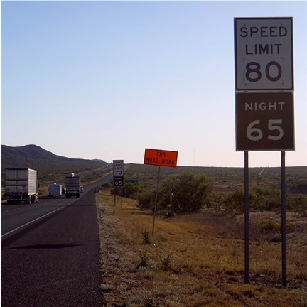
But I went as fast as I could (yes, that's a REAL sign in West Texas, highest posted speed in the country):
For about 100' anyway.

-
FOUND: At Campsite #276
Grey backpack with a few clothes, personal items and geocaching items.
We left it at the headquarters office on May 29, 2006
-
I'm looking for some troubleshooting help.
When I lookup a Travelbug and click on the "view in google earth" and click "open file" I get the following message: "Access to the specified device, path, or file is denied". My computer hasn't always done this. I tried the Google Earth upgrade for a while and then uninstalled it and reverted to the basic free version. I was able to click and open the file prior to this. For now when I click the KML link I select save rather than open and then open the saved file from Google Earth, but I would like to fix this error. Anyone know why I'm getting this error message?
FYI: the path is C:\Documents and Settings\Jackson\Local Settings\Temporary Internet Files\Content.IE5\.... however there are no folders in Temp Internet Files folder, only files and cookies.
-
I am familiar with the closest to the pin contest and plan on doing that one.
I'm also planning a GeoPicnic. Could you elaborate on this contest? And how it's played?
-
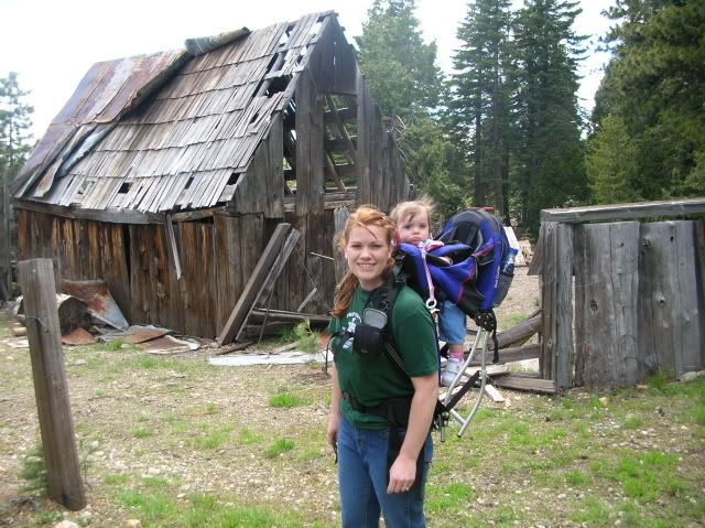
I sure do miss my girl - She passed away 2 years ago.
Geocaching just hasn't been the same without her.
This picture is of her discovering "Tiny Dam Rock House" cache (GCAE84)
We call it a Canine Tornado Shelter

-
We should be encouraging people to be more creative and descriptive in their logs. Using iconic shortcuts is the opposite of that.
I thought the point was to keep people outside Geocaching and not spending time on the computer? You could easily say the same about standard smilies and creativity in expressing your personal emotion.
However, I do see the point in too many smilie options. It does make me think of a more important topic and that is the actual cache condition. I was getting tired of posting caches in tip top condition in Texas
 and Soggy or floating away in California
  . Something like: [shiny happy cache], [not so shiny cache], [dripping wet cache], [non-existent].
Simply stated, smilies are not necessary. They're just for fun. A shortcut or quick addition to the log posted. Thanks for every ones opinions.
-
I did a brief search and didn't come up with anything on this idea, so if it has been discussed before please let me know.
I was logging several caches this weekend and wondered if it's possible to make Smilies of weather conditions (e.g. sunny, partly cloudy, cloudy, rain, t-storms, etc) Something similar to the icons the weatherman uses in his weekly forecast that we can add to our logs.
It would be a fun addition to the smilies especially since I tend to bring out the most severe weather conditions when I'm camping and geocaching.
Any other thoughts on this idea?
~Kim
-
 Some time ago I had watch-listed a cache in California because the posts alone scared me. They talked about snakes, bats, spiders and hiking way out to this place - I think maybe across a field and to a cave along the coast, but can't remember). The cache description talked about every phobia imaginable. I don't know what happen to the bookmark, but I'd sure love to find the link again, even if the cache has been archived.
Any other ones similar to this description?
-
Hubby sometimes goes along, but more often than not I'm out there alone. The geo field is pretty male dominated. I was one of a handful of women graduating from the Texas State University Geography department, but we're slowly balancing the playing field.
If there is anyone in the Texoma region I'd love to team up! See you at Geowoodstock 4 May 25-28 (GCRRC6)
Unfortunately, where I live it is very rural and there are lions, tigers and bears (Oh My!) in the surrounding wilderness, making it not only unsafe, but decidedly unhealthy for a woman (or anyone) alone to go Geo-hunting.
This brought back images of my sister who lives in a cabin 30 miles north of any Alaskan civilization... She told me she was getting fat sitting around the cabin all winter, so she decided to start jogging, but only when the weather is warm (above 0 degrees). She sent me a picture of her jogging outfit... complete with a Desert Eagle holstered to her hip.

-
Something to get you started... if you plan to use WiFi on your new PDA you'll want this website:
It allows you to log caches without loading all the graphics. Great addition to the geocaching website.
-
I have a iPAQ Pocket PC 2495 and when I first bought it I tried half a dozen different caching softwares: Sonar, GSAK and Cachemate to name a few. The one I stuck with is GPXView http://strandberg.org/gpxview/ I have never had it freeze up, it's simple, straight forward and does what I need it to do. It's also Freeware (they ask for a donation). If I could change one thing I would like to be able to mark caches as found. Currently you can't edit any of the information. But I don't really need to either. My favorite part is being able to open files individually instead of lumping them all together. I recently took a trip and ran 4 different pocket querries for 4 different regions I would be travelling to. When I got to that area, I set my home coordinated in GPXView, opened the file and then clicked to sort by distance. I HIGHLY recommend this one because it's simple and it's funtional.
 and Soggy or floating away in California
  . Something like: [shiny happy cache], [not so shiny cache], [dripping wet cache], [non-existent].
GEOCACHING IN NORTHERN BC, AB & NWT
in Canada
Posted · Edited by Texas-Jacksons
Thanks for the suggestions! I'm also traveling the Alaska Hwy and looking for a few easy in and out caches. Can anyone suggest a scenic cache location that would also be worth taking my fly rod alone with me?