


holograph
-
Posts
813 -
Joined
-
Last visited
Posts posted by holograph
-
-
Hello, friends. I let the holoscenes.com web site expire last fall, but still retain the domain names. It's been nearly 6 years since I moved to Maryland, and haven't attempted to update the statistics since. It became quite hard to download the activity from the NGS site, and now it looks nearly impossible to capture the recovery statistics and rankings for individuals on Geocaching.com, due to site changes over the years.
For old times sake, these were the last two maps:


-
Trying to find more of this series of BM's that I don't require asking favors for access to (most are on private property, a few on the land of a "well known celebrity personality"). After redoing the coordinates and using the descriptions, i'm stumped. Is it at street level in the weeds and dirt (public property), or up on the cliff face (private property)?
Also while i'm at it, this is also giving me a headache. I wanna say it's in that pipe looking thingy behind the rock wall, but I have a suspicion that the wall might've destroyed it.
#1 - given the measurements from the centerlines, I would guess it is on top of the lava flow.
#2 - Probably destroyed. It was across the street from house #3031, between the road and what was a wire fence at the time. I'm guessing that house #3044 was built since the mark was set, and its driveway was put directly on top of the mark. The "extended centerline of the driveway" would have been the centerline of house #3031. It looks like the driveway for #3044 was cut through part of the outcrop.
-
You know, I hadn't thought about that until you mentioned it. I normally think of the Mason-Dixon line as being the MD-PA border, but if I recall, they also surveyed the tangent line between MD and DE. I'll have to look it up once my books are unpacked. Are there boundary stones for the MD-DE lines?
-
Thanks for all the good wishes. Yes, when I moved to NJ 9 years ago, I used benchmark hunting as an excuse reason to venture out into the countryside and familiarize myself with the nearby area. Once time allows, I hope to do the same again in MD.
-
For those of you who have wondered about the lack of updates to the statistics and maps, here is the status.
Superstorm Sandy disrupted the November update by knocking out power for 7 days at the beginning of the month. After that, I got involved in buying a new home, which eliminated my spare time for the December update. This month I am actually packing and getting ready to move from New Jersey to the Maryland Eastern Shore, so I probably won't have any time for doing updates this month, either.
On top of all that, the NGS web site changed just enough to make it harder to get a good snapshot of activity, and it makes the process somewhat longer.
All that has combined to delay updates to the statistics and maps. I did do a download and update in mid-December, but found no new reports, so I didn't bother to do the rest of the process or update the web pages.
I hope to be more or less settled by February, although even then, renovations on our new home will probably be consuming a large fraction of spare time.
-
We just got power restored to our house yesterday (Monday the 5th). It was off from Monday to Monday, a full week. There has been a large amount of damage where we are in Sussex County, NJ, but fortunately, the trees surrounding our house managed to stay (mostly) standing, with no damage to us. Nearby homes were not so lucky. There are large numbers of trees down, and many power lines still down or dangling. A number of nearby streets are still closed. A large amount of cleanup remains to be done, with no help coming from the nor'easter forecast to hit the same area tomorrow.
As Harry mentioned, odd-even gas rationing is still in effect, although the long lines at gas pumps seemed to have abated. There are no generators or gas containers available in northern NJ and eastern PA.
-
A nice overview, good pictures, but it doesn't tell you how to calculate anything.
I'm going to check out some of these:
What are you hoping to calculate? As far as I know, the various heights are measured, or calculated through the models that the NGS has. I'm not sure there is any kind of reasonable do-it-yourself calculation, other than making use of the NGS models and tools.
For instance, you asked "How do you find the geoid under a land mass?" I think one answer is "first, you launch some satellites, then you build a network of laser and doppler ranging stations that can precisely measure the paths of the satellites, and you then run some computer models on supercomputers to calculate the location of the geoid, taking into consideration tides and seasons."
Or another kind of answer would be "you look at the datasheet to see the geoidal height" or "you use the NGS geoid model tools".
-
A concise (perhaps too concise) summary of orthometric, dynamic, geoidal, and ellipsoidal heights is on page 75 of "Introduction to Geodesy" by James R. Smith.
-
Over the weekend I was reading one of his reports to see if I could discover how the King triangulation was done, when there were virtually no reference points available. I was interested to read that they started at the westernmost end with a 64-mile "base line" that was measured by finding the astronomic latitudes of two peaks nearly lying north-south of each other, and computing the base line distance based on their latitudes and azimuths. Hardly a precision method!
Here are a few snippets from the Geodetic Appendix to the first volume of the King report, pp 763-769:
The Union and Central Pacific railroads, which now traverse this section, were not built when the Fortieth Parallel Exploration was begun, and no maps of the mountain ranges existed upon which even the roughest geological work could be based.
Stone cairns were placed on the peaks selected for stations, and were the only signals used; but these being invisible, except on shorter lines, exactly the highest points of the mountains were usually observed. These culminating points of Cordilleran summits can generally, by a practised eye, be determined within a very few feet.
It really is amazing that they accomplished what they did.
-
Still working on map scouting & pinning on GE the 75 points that holograph identified for me on King's maps; but this one seemed interesting enough to add to this thread right now.
20 JUN 2006 PHOTO BY nvsrvyr
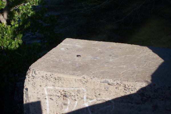
Don't know if King placed this, but wouldn't they have used a nice permanent hard point if it was available? MEL
Unless you have evidence to the contrary, I doubt that the railroad used much concrete when it was first built or when the King surveyors would have been in the area. Railroads tended to be built on the following principles: do grading, and lay rails as quickly as possible, often with widely spaced, unballasted ties laid directly on the grade. The bridges tended to be timber trestles, which were later either filled with rock to form embankments, or which were later replaced with iron or steel bridges.
American railroads were built fast and shoddy, in order to get revenue as quickly as possible, and were then upgraded later.
-
The Lat/Long given for the 1908 Tri Station is ENE about 200 ft from the current
adjusted PILOT RESET. Would that be about right for the changes in 100 years?
Another piece of the puzzle: The CGS Special Pub 212, "Triangulation in Wyoming [NAD 1927]", has this station description. Note that it is reported by C. I. Alsakson, the "CIA" mentioned in the current NGS datasheet. That resolves the issue of whether 200 feet is a reasonable difference between datums over 100 years (it is).
Pilot (U. S. G. S.) (Sweetwater County, C. I. Aslakson, 1931). -- On highest point of summit of prominent elevated table-land (with precipitous sides) known as Pilot Butte. To reach from Rock Springs go northwest 12.2 miles (1.2 miles beyond end of pavement) on U. 5. Highway 187 to point where very dim road turns left from main road just east of guard-rail, follow dim road 1.7miles up onto table-land to point where road comes in from right, keep to left, go 3.3 miles to fork, keep to left on main road, go 4.4 miles, take right fork, go 1.4 miles to point where very dim road turns to left toward butte just after crossiug draw, turn left and drive to foot of butte. Station is easy 30-minute pack up northeast corner of butte. Marked by standard U. S. Geological Survey station disk in drill hole in rock outcrop. Reference marks are standard reference disks in drill holes in outcropping bedrock, note 12a. No. 1 is near north edge of butte, 10.925 meters (35.84 feet) from station in azimuth 208°43'. No. 2 is 7.10 meters (23.3 feet) from station in azimuth 321°47'. Following azimuths are from station : Salt Lake-Omaha Airway, site 15, beacon, 340°20'38"; Boar's Tusk. 199°46'35". Elevation: 2.417.8 meters (7,932 feet.)So Pilot Butte has appeared in 5 distinct publications:
Survey                   Year Surveyor        Position                                Datum
------------------------ ---- --------------- --------------------------------------- ------------------
King survey map II       1876 A. D. Wilson    N 41° 38' 28       W 109° 21' 04        none (scaled from map)
Hayden survey report     1877 A. D. Wilson    N 41° 38' 34.00    W 109° 21' 19.60     none
USGS Bulletin 440        1908 R. B. Robertson N 41° 38' 37.52    W 109° 21' 05.1      U.S. Standard 1901
CGS Sp. Pub 212          1938 C. I. Aslakson  N 41° 38' 36.528   W 109° 21  04.889    NAD 27
NGS Datasheet MQ0466     1993                 N 41° 38' 36.40815 W 109° 21' 07.37282  NAD 83
If we calculate the differences between the positions, here are the results, in meters.
Hayden USGS 440 NAD27 NAD83 -------- -------- ------- ------- King 1876 186.9 m 294.8 m 263.9 m 270.9 m Hayden 1877 - 352.7 m 349.3 m 292.6 m USGS Bull 440 - - 31.0 m 62.8 m NAD27 - - - 57.6 m -
Thanks for the reading material - I was wondering what to do after midnight!
...
"Signal and station mark: A cairn 5 feet high centered over aluminum triangulation tablet cemented in solid rock."
from page 660 - USGS Bulletin 440 "Results of Triangulation and Primary Traverse 1906, 1907, and 1908".
The Lat/Long given for the 1908 Tri Station is ENE about 200 ft from the current
adjusted PILOT RESET. Would that be about right for the changes in 100 years?
Also intriguing. Might "MR0823 MEDICINE BUTTE STATION MARK--METAL PLUG 3/4 IN. DIAMETER,
SET IN ROCK" be the station made by A.D. Wilson in 1878?
There have been multiple adjustments since then. The 1908 position would be the old US Standard datum, which was adjusted when NAD27 was introduced, and again when NAD83 was introduced. 200 feet is not out of the question, but unless we had access to the USGS data sheets for 1908, we can't be sure that the aluminum disk is a reset of the old King Survey mark, or whether MR0823 is.
When you can find station descriptions from other old surveys, such as the Wheeler survey or Hayden surveys, they often used rock cairns to mark the station, especially on peaks. They weren't striving for millimeter accuracy -- Wilson noted in 1978 that he was quite pleased with an 8-inch closure error, given the equipment he had.
"---; also made a station on Medicine Butte, thus connecting with my former
work under Clarence King in 1871 and '72."
PRIMARY TRIANGULATION OF 1878 P. 655.
Mr. Wilson and party had a very interesting summer of '78: peak bagging, total eclipse of the sun,
verification of live glaciers in the Wind River Mountain, traveling with Mr. Jackson, the photographer,
and a minor run-in with Indians at Henrys Lake.
kayakbird
Yeah, I really like the way they wrote up their campaigns -- there is a lot of intriguing information there, even if it is just a sentence or two. "Mr. Bechler being compelled to leave the field earlier than he would have done on account of the Indian troubles, he did not finish more than half of this section."
-
Of course, what I really interested in is this note with a recent Geo log:
'Not only did we find Pilot RESET, But we even Found PILOT! At least the steel rod driven into the rock that was described as Pilot!' Described where, I wonder??
Yes, I'm map scouting for another road trip across the 40th. Will renew that thread in a few days.
kayakbird
The first description that I found was in the USGS Bulletin 440 "Results of Triangulation and Primary Traverse 1906, 1907, and 1908".
"Signal and station mark: A cairn 5 feet high centered over aluminum triangulation tablet cemented in solid rock."
edit: An interesting aside: apparently A.D. Wilson occupied Pilot Butte during the Clarence King survey of 1871-1872. It appears as a triangulation point on King Survey Sheet II. The King survey was one of the first surveys in the west to use triangulation. A.D. Wilson mentions revisiting the point in 1878.
-
-
holo, what's the PID on the JMA unknown mark?
Remember I was going to change my initials to that letter set since the county where Geonist has done all of his marks is somewhere I would never go. I just wanted to see if that was one of mine.
It looks like it is MD0892, in Whitley County, Indiana.
-
Curious, by I don't want to add to your problems... I thought that I had 26 logs in Sullivan County, New York? Now, it's only showing 25. Not enough to change the color. I can go looking for another, I guess. Just curious if one has been delted?
LY2291, which you recovered as NOT FOUND in 2008, has been removed.
edit: Just a note, the archives at this page still include LY2291 from September 2008, because my archive is updated by merging, not complete replacement. So datasheets that have been deleted recently may still be available in my archive, even though they are not available online at the NGS site. Unfortunately, as a result of the changes that made, the statistics are now obtained from the NGS archive, not my own, so the deleted stations are no longer counted.
Here was your recovery report:
LY2291 STATION RECOVERY (2008)
LY2291
LY2291'RECOVERY NOTE BY GEOCACHING 2008 (PR)
LY2291'BRIDGE HAS BEEN REBUILT. NEW DISK RESET BY NEW YORK DEPT OF
LY2291'TRANSPORTATION MARKED G 449 1982 RESET 1999.
-
The September statistics are available on the statistics page. The maps and counts by county have been updated also.
There were 861 datasheets updated with new GEOCAC recovery logs. The most recent recovery added to the datasheets as of October 6 was September 17.
Please note that due to changes at the NGS site, it is impossible to capture the most recent datasheets for all states. The statistics are now based on the archived datasheets. Some states may be more than a month out of date. Even if you see your recovery report in the online datasheet, the NGS archived datasheets may still be out of date (see the NGS archive). If your state's archive is dated more recently than October 6, then it was not included in these statistics. If your state's archive is dated older than the date on which you first saw your report appear online, then the NGS archive is simply out of date.
Yes, it's messy. There is nothing I can do about it. In short, if you think your reports have not been counted, wait until you are sure the archive has been updated before complaining about it. Better yet, download the archive yourself and examine the datasheet to see if it contains your report.


-
If you go to the NGS page to download datasheets by load date, you will see that it is broken.
That means that the only way to obtain updated datasheets is by downloading the full archive. Each state's archive is updated on a different date. For instance, as of Oct 6, Iowa, Illinois, South Dakota, and others had last been updated September 3-8, while several New England and Western states were updated Oct 2-6.
It makes it difficult to get a "fair" monthly snapshot. Some states will be more up to date than others.
-
And lastly, the Power Squadron is no longer actively reporting marks. They used to have incentives for their members to find and report marks, but they discontinued that program a couple of years ago. I don't know exactly what the incentives were -- whether they were carrots or sticks -- but they tended to generate a lot of reports, many of which were dubious accuracy.
-
What are some of the states and counties that have updated datasheets?
-
Jim,
Just pulled up the current DS for my recoveries this summer and they are up to date through the last one found on 19 Sept 2012 and submitted 30 Sept 2012.
kayakbird
That's interesting, because it implies that the retrieval by load data is not working correctly. Unfortunately, the full archives are not updated all at the same time -- it looks like about 3-6 states are updated each day, whatever can get done between about 5-7 AM, and there is no single date when all datasheets are available.
-
There have been no new GEOCAC log files published for the last two months, so no new statistics. At some point, I plan to do a complete archive download just to check that the NGS datasheet retrieval by load date page doesn't have a bug that is preventing new recovery reports from being captured in my monthly process.
-
Still no sign on the data sheet for HR0546 which I recovered June, 30th. Probably reported a couple days after. Is reporting not working through the NGS page?
The reports that you submit to the NGS go through a review process before being published. It is not unusual to take a month or more before they show up. For example, as of August 1, the most recent report that had been published was dated June 24.
-
Is the list of initials up to date? Because mine don't show up. I logged one benchmark in June, though I don't know for sure when the datasheet was updated. (I know I checked it after seeing the July Statistics thread and the recovery report is there.)
The easiest way is to go to the NGS web site's datasheet retrieval by load date, select August 1 through the current date, and see if your recovery shows up. If it does, then it was added sometime after July 31, and will show up in next month's statistics.
It shows up as being added July 25th.
I've discovered that a subtle change in the NGS web site response confused the robot that retrieves the monthly updates, and thus some datasheets were not retrieved. I am in the process of re-retrieving the June and July datasheets and will update the statistics and maps when that process is complete.
So far I've found about 90 additional reports that had been missed, yours included. Thanks for noticing and bringing it to my attention.


Groundspeak is removing Benchmarking and the logs/photos
in Benchmarking
Posted
All, I haven't been active here in about ten years, but from about 2004-2012 it was a fun and educational place to hang out. Not only was it interesting to check out everyone's new photos and logs, but often a unique find would trigger a fascinating discussion here. The photos could be works of art! I loved the 2oldfarts finds out west, where the landscape was so different from the East. And the discussions -- some examples that come to mind were about the 4 Corners [mis]location where New Mexico, Arizona, Utah, Colorado meet, or about the Wheeler survey markers in Utah and Salt Lake City, or the Mason Dixon markers, or some of the old-time aerial navigation markers before radio navigation, or the MIssouri River finds, or the IBC Canadian boundary markers. And then there was Dave Doyle's endless patience and boundless knowledge with respect to the NGS and geodetic datums.
Thank you all for a great community and fun hobby. In internet years, this niche of geocaching.com goes back to nearly pre-historic days, and it is a wonder it has been kept around as long as it has. Nevertheless, it is sad to see it disappear. I just went back and captured all of my logs as PDF files, because some of the discussions happened in the logs where one report would comment on another report and could result in a little micro-community around certain areas. Harry Dolphin and I would frequently follow in each others footsteps, and occasionally puzzle over a hard to find mark -- and never once met in person!
I wish you all the best,
Holograph