


planetrobert
-
Posts
1917 -
Joined
-
Last visited
Posts posted by planetrobert
-
-
Am i missing the boat? I just use Mac GPS Pro to transfer waypoints to my Garmin 60cs. Seems the program does a heckuva lot more. Any source for maps? I have the Garmin map but no Mac compatability as of yet. Hoping to learn a little something!
you can get maps here... http://libremap.org/data/ which are not imported to the right format yet, but are calibrated.
or you can buy maps for cheap from macgpspro.com which are already calibrated and imported.
-
convert the gpx file to an html file using GPSVisualizer. Then "find" the cache info using the GCXXXX title gleaned from your MacGPS Pro map.
yeah, i convert the gpx to text and html for the offline times. I use the palm for when not in the truck.
-
This is the program to have on a mac.
No, it does not autoroute or any of that fancy directions stuff. What it does though is AMAZING.
I went out today caching and dropped the laptop in the passenger seat... wait, let me start at the beginning... earlier in the day.
So I started out my caching day as I used to do in the past, but with a new twist. I love planning out my route before I ever leave the house. So I opened the maps for the local area and my unfound gpx file. I then clicked from cache to cache planning my route. Enough with the preflight talk.
I went driving around town snagging caches this afternoon and the ability to have a live map was awesome. I plan to road trip this app over winter break but based on this short trip out it is great. All I need now is a mac gpx reader app for cache pages...
 ...still got to have the palm for cache pages in the field.
For $50 this was the greatest mapping app I have found. You can load your own maps or buy maps or even load treasure maps. Very cool program. I of course use a second gps to plug into the computer as unpluging at every cache would suck.
-
freebee

-
I agree. Not only have I never seen a mark set, I have never even seen a mark being USED. And I have searched for 1,200 marks. The benchmark gods are against me in that respect.
I must be a favored mark hunter as I have seen several marks used.
-
You are correct. So far, we have not found anyone willing to revisit the hundreds of thousands of benchmarks to chisel a "1" in front of that "250".
70 years ago, no one thought through the idea that a metallic marker does not lend itself to adjustments for inflation. [grin]
-Paul-
I ... have ... an ... IDEA
-
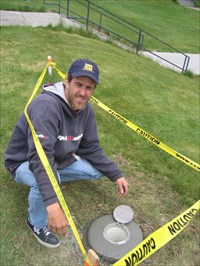
I was just out with a NGS crew(the real guys), and we used a backhoe to try to recover a benchmark. We made a wicked hole before filling it back in. No luck in our hunt though. Digging... Yeah I think it is ok, but get permission for sensitive or private lands.
-
How did you know they were going to be there and setting a mark? Did you just drive by or did your school tell you?
The buzz in our department was very high about the crew arriving. We had a couple months worth of notice.
But, of course they let you "dig that hole", right?

Actually the grounds crew used an auger to bore a 2ish foot deep outer hole and about anothen 2 foot of smaller hole in the middle.
Just how deep is that hole and how do they place the rod into it? Tell us all of the details, please.
The rod is threaded is 4foot sections and drive in using basicly a jackhammer device that instead of having a point has a slot/hole for the rod to slip into. We drove the rod 32feet in till it hit bedrock and refused to travel farther. When the rod was in they use a hydrolic cutter and a grinder to dress up the end. The process is fairly simple but if you have any specific Q's just ask and I'll try to answer them.
-
I am sure the dozen or so other persons around would have looked kindly on that

-
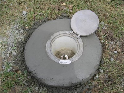
Hey, that cement still looks wet!

Hmmmm, maybe that is cause it was JUST set


-
What was the newest benchmark you have ever found?
Did you ever help set one? An NGS crew was in town today and guess who got to help out
Being a Geomatics(Surveying) student has its bonus'. This was a very rare occurance as there is actually only one crew currently doing this work for the whole US due to budgetary reasons.I am beside myself with joy
-
hmmmm, nano in the middle of the forest...hmmmmm
-
it is the yesterday bug
-
actually that is an old and know of bug.
-
They could restrict these PQs to your home state only.
How about us border dwellers...
-
I'm of the opinion that new tech, such as paperless caching, has simplified the preparation process, but otherwise has made no change in the game.
I rather liked the pre-pda days where you would print off 20+ pages and then sort then out based on best route. That of course was AFTER you had researched your intended route for the day. I did that today for my cache spree and it was perfect... well i didn't print, but I had it all on my pda and a printed map with a route drawn on it.
back to the good old routine
-
dead battery AFTER A HUNT...in the car
-
I used to cache a ton... I got more equipment... and then some more... then a little bit more... then some more software... then a bunch more equipment. I had nearly achieved the point of being able to sign a logbook while siting on the couch.
Things got wild... I could find any cache anywhere in a matter of minutes no matter the hide it seemed. Being familiar with all the local's hiding styles helped too. I had a palm with a gps attachment AND cables to plug it into my other gps'. I had software to do anything. Tell me where the cache is, who, what, when, where, why, and how... about the hide. Several pieces of mapping software on the palm as well as on my gps.
I got burnt out on it. I had to manage all the data before I went out. That took up to 10-15 minutes just for a simple outing. I had to keep all my files straight and make sure I had current data. The hunts were getting simpler... partly due to the types of hides, partly all my toys. I will not go into the urban-micro debate here
that is not the point. Technology was my enemy, I love technology but it was not making things simpler for me, if anything it was harder. Now I went out today for my first hunt in months? year+? I got one for three today
 with only my palm gps running cachemate with cachenav and a mapping app to get me close. It was cool. I think I will just take a standalone gps in the future to simplify it more. On trips out of town the mapping laptop will come with me and I will run that as my co-pilot in the car. I might take my palm with me, I might not.
I thing that at a certain point TECH needs to go away and simplicity rules...
I'm BACK
-
email sent, but just re-read the post and I have the version for the palm m515, not sure if it would work, but a try "shouldn't" hurt.
-
seems to work now... mine loaded
-
Keyspan has a good reputation:
I second that one... i have it
-
In this case, a waypoint that was entered as an "extra" waypoint in a cache would have just one additional Groundspeak-specific tag. Something like this:
<wpt lat="37.31745" lon="-122.144883">
  <name>P1J1F6</name>
  <desc>Parking Coordinates for cache GCJ1F6</desc>
  <Groundspeak:cache_link id="126550" wpt="GCJ1F6" idx="1">
</wpt>
All the information required to link this waypoint to the cache, including the sort order, is in the <Groundspeak:cache_link> tag. In the example above, "id" is the id attribute of the Groundspeak:cache tag, while the "idx" attribute is the sort order index for this waypoint among all the waypoints linked to that cache.
This looks like the best incarnation of this idea yet.
A question though... would this be a selectable thing for a PQ, something that we wouldn't really have to get?
AND
would these points count against our 500?
-
-
another site that is good is ... http://www.pc-mobile.net/grdc.htm that is where you should find cables for your gps/pda
 ...still got to have the palm for cache pages in the field.


 with only my palm gps running cachemate with cachenav and a mapping app to get me close. It was cool. I think I will just take a standalone gps in the future to simplify it more. On trips out of town the mapping laptop will come with me and I will run that as my co-pilot in the car. I might take my palm with me, I might not.
MacGPS Pro
in GPS technology and devices
Posted
you can get maps here... http://libremap.org/data/ which are not imported to the right format yet, but are calibrated.
or you can buy maps for cheap from macgpspro.com which are already calibrated and imported.