


ibycus
-
Posts
2073 -
Joined
-
Last visited
Posts posted by ibycus
-
-
Currently stuck at 81.6% - doesn't seem to be any seeds
There will be in a minute (I had to shut my computer down...)
-
How do I download this using utorrent?? when I click the link I just get a lot of gibberish
Try saving the target to a file, and then running it. It seems there may be a problem with MIME types on my server and torrent files. (so it gets recognized as ASCII, rather than binary).
Dale
-
Just released version 3.0. For the moment, the torrent is likely to be a bit flakey, as the only seed is on my home computer
 .
. If you're fed up waiting for the torrent to grow, I can mail you a DVD.
The URL for the torrent file is http://www.ibycus.com/ibycustopo/IbycusTopo30.iso.torrent (hopefully all my firewall settings etc. are OK...).
Dale
**edit: Suppose I should tell you some of the new features:
Updated roads (of course), including road names in Ontario.
Road data is as follows:
Province / Territory| Edition| Release Date| Validity Date| Number of km
British Columbia 6.0 2009-05 2009-03 79,238
Alberta 6.0 2009-05 2008-10 231,569
Saskatchewan 3.0 2008-12 2008-12 250,459
Manitoba 3.0 2008-11 2008-04 87,960
Ontario 5.0 2009-08 2009-08 234,962
Quebec 2.0 2007-06 2002-11 148,108
New Brunswick 2.0 2007-06 2003-06 31,830
Prince Edward Island 8.0 2009-05 2008-12 6,760
Nova Scotia 7.1 2009-08 2009-02 46,038
Newfoundland and Labrador 6.0 2009-08 2009-07 21,504
Yukon 7.0 2009-07 2009-02 6,043
Northwest Territories 5.0 2009-10 2008-09 5,374
Nunavut 4.0 2009-05 2006-09 916
New datasource (I'm now using the CanVec data source as opposed to the NTDB datasource). This datasource has a wider coverage area than the NTDB data, and seems to be better maintained. It had to be done, but basically meant going back to square one on the maps, and had to rebuild all the associations)
The up side is, there are several hundred megs more data in this version than in the old version.
**note: the above link will only work if you have a bit torrent client installed. I use utorrent from http://www.utorrent.com.
-
What is the latest version of Ibycus topo (2.1?)
That is the latest version that I've released. I'm working on 3.0, but I've stalled on it due to outside matters (life).
-
I don't trust P2P software, and am loath to spend the time tracking down a version that isn't riddled with spyware. So I ended finding a source for a "conventional" download, but didn't trust that either - until I dug up the MD5SUM from an old blog post, and verified my download.
Just a suggestion... Bittorrent.
Torrents automatically verify file integrity and the actual Bittorrent client-side software is spyware, adware and malware free. It's also cross-platform: Windows, Mac and even available to us Linux users for once! You still need to practice common sense about your downloading habits, but once you've learned to use torrents you'll never want to go back to http downloading.
A little suspicion about your download sources and files is a good thing, but by the same token there are safe ways to do this. Bittorrent is one of them.
The problem with BitTorrent, is if you don't know exactly who set up the torrent, or which torrent to choose, it is absolutely possible that you'll run in to a counterfit torrent. As I'm not running my own server, I've been unable to host the torrent tracker on my site, so I've had to off load it on "The Pirate Bay", which is a somewhat questionable place to put it, but the 'most reputable' of the free torrent tracker sites I was able to find. (actually, I didn't even set up the USA torrent myself, so don't know exactly where the most reputable version is...)
As far as the client goes, it depends somewhat (I would imagine), on what client you choose to use. (I've had good luck with http://www.utorrent.com)
-
Thanks for the input Ibycus, but it is still not working
I unzipped with built in MS unzip and click setup....hangs(not responding)
Maybe I'll try another zip prog while I wait for the iso
I think setup.exe is corrupt/missing on my reg zip file though
I'm downloading the iso now
I really hope its not the PB torrent
What little of your work I've seen is outstanding!
.... I hope to see more soon

Cheers
Hmmmm.... If it unzipped without error, I'm guessing the file is *not* corrupted, so something else is probably going on.
Right now, I'd just try installing using "MapsetToolkit", rather than fiddle around trying to get another copy which will likely work the same.
-
A request for missing maps...if you have the time. Thanks.
I believe they are 86L1,5,6,7,8,9,11,12. 86K11,12,13,14,15. 86N4.
Hey, this is a problem with lack of data (I'm fairly sure). These may be purely 'water' tiles, and so no published map for them. Its also possible that they *might* be included in the CanVec set --- we'll see.
Dale
-
Ooops, should have mentioned that. The size of the file I downloaded was 3,181,512kb; I'm using Firefox 3.0.
Hi all,
I must say; informative thread and GREAT work Ibycus!
I seem to have the same issues as above, the dl seams to come in fine but only 3.03g- no setup.exe
Ibycus or anyone, is there anyway to fix this zip file? It took 12.5hr and all my bandwidth
I'm using winrar and mapsource6.15.6 Are these the issues?
WinRar Would be the issue. It doesn't like the really big file. Unzip with something else. (WinZip, 7Zip, built in Windows unzipper)
-
Hi,
Can Ibycus confirm the explanations of Red90, which seem corrects by the way?
Yep, I can confirm that.
-
Dale, Religious Buildings show up on my Oregon as the Amusement Park icon. Any chance of that being corrected for the next release?
All associations are being re-done for the next release. I'm sure some will be better, others will be worse.
Dale
-
Ontario Roads have been updated at geobase:
Registered Geobase users can download the Ontario NRN dataset at no cost as
ESRI Shapefile
Geography Markup Language
Keyhole Markup Language (KML) for Google Earth (only contains National Id's, street names and place names - see attachment)
Cool! Expect an update soon.... I've wanted to get this in there for a while, and I'm all set with my base files for at least a beta of 3.0, so I'll try and get the roads adding in tonight, then compiling --- hopefully I'll have an update by Monday.
Dale
-
The other day I was out caching while on holiday. Went for a 'micro in the parking lot', just to be able to say I'd found a cache in California. Anyways, I've been away from the game for a while (still am, really, thanks to school/work keeping me very busy), and when I powered up my GPSr, it was giving me to strange behavior.
I had a clear view of the sky, good fix on lots of sats (estimated error 4m), but the GPS would periodically zero out in one place, and then 2 seconds later, would say I was 30m away, I'd go where it said, and it direct me back to another point.
It was probably some weird sat configuration, or maybe some kind of multipath issue, but I'd never experienced quite this type of problem before with my trusty 60CS, and I've cached in all kinds of terrain. I'm wondering if there might be some kind of hardware issue going on (Nice fresh batteries in it too).
Thoughts?
-
{bump}
I've noticed a number of people with this problem lately (myself included), probably because Vista 64 is becoming more common than once it was.
In fact, I installed Vista 64 myself, and ran in to this exact problem when installing my own maps (I'd seen a few people with this problem, but only just managed to tie it with problems installing under 64bit windows...I'd been assuming a somehow corrupted download)

Anyways, thanks for the tip. I'll be bookmarking this thread for future reference.
Dale
-
Any updates on when your new CanVec maps will be available?
I plan to launch a beta fairly shortly. I've got it ready, just need to re-write/update the setup program (might skip that part for now). Bit of a delay as I decided to reformat my computer and load up Windows Vista (for various reasons).
-
Interesting, it seems like I am not able to unselect the tiles I don't want anymore. I will try again tonight to verify when I am on my mac.
I loaded some maps for Colorado and Utah for a vacation trip, and don't think I need them again in the near future.
Thanks for the feedback!
Are you sure you're using the right program? Isn't there a couple of different programs on the Mac?
-
Depending on the version of the maps, there may or may not be an uninstall included in the download. The quickest/easiest solution is to use MapsetToolkit to remove the offending mapset from the registry (after which you can remove any of the associated files). MapsetToolkit can be downloaded from http://cypherman1.googlepages.com/ , and is pretty easy to use. Let me know if you have any trouble with it.
Dale
The maps were installed July 2008 (not sure what version) no uninstall program in the folder.
I tried the MapsetToolkit download (only 1.62 beta available) and it will not execute.
Thanks for the quick reply.
What error is it giving you when you try to run it?
If you're comfortable mucking about in the system registry, I can tell you the keys to delete to get Mapsource going again, but as I'm sure you're aware, if you nuke the wrong thing in the registry, you can screw up your computer. (It isn't hard, you just have to be able to follow instructions and be sure of what you're doing, before you do it)
Dale
-
"Street names are only available in the provinces/territories where the data has been released by the government. (Alberta, BC, Nova Scotia, Yukon), and will be added for the rest of the country as the data becomes available (technically the Ontario data is available, but there is a $100 access fee for the data, and a little birdy told me that it might be released publically soon anyways)."
Any ideas as to when this may be available?
If not soon, I would be willing to contribute toward the $100 access fee and am sure other satisfied users of your maps would also contribute.
I *think* it may currently be available, I just haven't (quite) worked out how to access the data (there is a whole big form I have to fill out).
Dale
-
Hello Ibycus
How can I uninstall an old version of your map (TopoMaps) from my pc?
I tried the mapupdate the other day and it did something to one of the files.
When I try to start Mapsource I get the following message.
"There is a problem with the NTDBData installation. Please re-install NTDBData and start MapSource again."
I downloaded and installed the newest maps (IbycusTopo) yesterday hoping it would take care of the problem but I still cannot get MapSource to open.
Depending on the version of the maps, there may or may not be an uninstall included in the download. The quickest/easiest solution is to use MapsetToolkit to remove the offending mapset from the registry (after which you can remove any of the associated files). MapsetToolkit can be downloaded from http://cypherman1.googlepages.com/ , and is pretty easy to use. Let me know if you have any trouble with it.
Dale
-
We have a tutorial here on loading maps (both Windows & Mac):Doh! I had a brain fart. You use map install, not road trip.
Thanks everybody for replying.
http://www.gpsfiledepot.com/tutorials/how-...armin-gps-unit/
Hey, thanks, could've used the info last week, but it is a good resource.
Looks like I managed to download the ibycus topos just in time. This week I would be screwed.
They should still be available via bit torrent... They just aren't seeded from my website any more.
http://torrents.thepiratebay.org/4492135/I...135.TPB.torrent (Zip Version)
http://torrents.thepiratebay.org/4490137/I...137.TPB.torrent (ISO version)
You can get a bit torrent client from
http://www.utorrent.com (among other places)
-
I believe he means that the MAC version is not being seeded ATM.
Dale, have you contacted them and talked about this? It is probably over automated and face to face communication might simply fix things up. Pull the direct downloads and setup web seeds only.
I spent several hours with the 'abuse' deparment about this. (Not sure why using the service qualifies as abuse, but hey...).
I managed to get them to reinstate my e-mail accounts, so at least I can respond to all the people wondering where the heck my site went.
Beyond that, they basically just want me the heck out of Dodge, which frankly I can understand. I just would have appreciated being dealt with a little more professionally on their part. A little warning would have been nice. (and I've been told that it wasn't an automatic thing. Someone had to go in there, and manually disable it...)
Dale
-
Apparently, Hostmonster (that I use to host my maps) advertises a service they can't provide. I just received the following from them:
Dear Dale:
Your web hosting account for ibycus.com has been deactivated (reason: site causing performance problems).
Although your web site has been disabled, your data may still be available for up to 15 days, after which it will be deleted.
If you feel this deactivation is in error, please contact customer support as soon as possible
With 2 to 4TB of traffic, I can't say I'm surprised. When you get your new web hosting setup, I'd suggest you keep the downloads to BitTorrent seeding *only* or this will just happen again.
What bugs me, is not that they pulled the plug. I can understand its a shared server, and that there is no way they can reasonably actually provide the service they advertise.
Its the *way* they pulled the plug. They claim to offer "unlimited bandwidth", and then call my use of the site 'abuse'. If they had said "Look, we can't continue to host your domain if these downloads keep up, we're sorry, but that's the way it is." and then given me some time to figure out a way to reduce them (like go to exclusively BitTorrent seeding, which I'd planned to do on the next release anyways, or move the main download location off site, or, or, or), I would have been more than happy to continue doing business with them.
But they are hitting me like its me not living up to my end of the bargain. The only thing they have offered to do is refund the remaining term of my contract with them (I'd hope so too, as they have said they won't provide the service!). All I've asked for is for them to refund the entire contract period as a show of good faith, i.e. some kind of acknowledgement that they are the ones who haven't lived up to their end of the bargain (I think I renewed some time last year, which would only be about $50 more for them).
In return, I've offered to sign someone else up with them for an extended period (I was planning on recommending them to a friend of mine who I'm helping set up their website on Sunday...needless to say, based on the way they treated me, hostmonster won't be getting my recommendation)
Dale
-
Apparently, Hostmonster (that I use to host my maps) advertises a service they can't provide. I just received the following from them:
Dear Dale:
Your web hosting account for ibycus.com has been deactivated (reason: site causing performance problems).
Although your web site has been disabled, your data may still be available for up to 15 days, after which it will be deleted.
If you feel this deactivation is in error, please contact customer support as soon as possible
-
I downloaded the mac version-it took 24 hours, but no problems, ....
I don't know how you got it in 24 hours, I'm 24 hrs in and am showing 32% complete. Hopefully my browser won't crash this time.
Hey Ibycus, tell us more about the new version you have slated for the end of this month. Did you find data that is more detailed than gc.ca? I can't wait...
It will be based on the CanVec dataset, which is better maintained by the government than the dataset I was using. Also it will include updated roads through many areas of the country (unfortunately, no more road names than what I had before... I think).
I'm also going to be making the download exclusively BitTorrent (although it will be seeded from my website). Hopefully this will speed up my website (it is *painfully* slow right now, even for me to check my e-mail). I've noticed total monthly downloads have essentially dropped in half last month, so I know its hurting everyone (they went from >4TB to just less than 2TB. ).
Oh, and I *really* strongly encourage the BitTorrent download over the website download.
Dale
-
I downloaded the mac version-it took 24 hours, but no problems, opened the file, installed it and can view it in
road trip. it looks beautiful, great job!
What I can not do is transfer the ibycus topo maps to my etrex vista cx. I can transfer routes okay, and I checked the box in preferences to send map with user data, but no map...
Does anybody know what I am doing wrong or is there some other software I can use to transfer the actual topo map?
Hmmmm... Are you sure you're using the right program to send them to the GPS? I seem to recall there being a couple of different options on the Mac... I'm not sure any more which was the correct one.

Free Topo Maps for Garmin GPS
in Canada
Posted
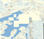
I can confirm that this is a bug, and that I hope to have it fixed soon. (will require a new download )
)
The problem is, the entity type I chose for lakes (Blue - Unknown) doesn't shows as white in mapsource (go figure).
Can you confirm that it does NOT show on the GPS either? Can you see *anything* else wrong with the maps? (I don't want to be going through this whole thing again in a short while).