


Grasscatcher
-
Posts
1114 -
Joined
-
Last visited
Posts posted by Grasscatcher
-
-
Go to NGS site or GC site and hunt for BM in your area.
Find a local Benchmark near your location that has "Adjusted" horizontal coordinates. Those coordinates will be "Dead On" accurate, even closer than your hand held consumer GPSr is capable of.
See which unit most closely matches those coordinates.
-
Jest couldn't figure out what was so bad about what shape or what kind of paper it came as......if it cashes or deposits,or spends....that's all that counts!
-
What would you do if "they" wrote it on toilet paper?
-
Mine just says 1.3.0 and GUI 2....but who cares... as long as it works!
-
I've complained to garmin a couple of times about the inability to ignore the baro. They keep saying they'll send it on to the programmers and occasionally they use user input. Whatever.
Anyways, the NMEA output seems to be GPS altitude (right now my baro's saying 740m, the gps is saying 675. Actual seems to be about 665 here - what's more accurate?). No way to display it on the unit, but at least it is output somewhere....
If you want to ignore the barometer, why don't you just set your unit on "Fixed Elevation"? That way it forces the unit to use (record) the GPS elevation. At least that is my interpretation, based on my manual which says "Trip data is not recorded when in Fixed Elevation Mode". That's just another use for that setting, as a "disconnect" between GPS and Altimeter so that the Altimeter can function just as a Barometer.
"Not sure what you mean by "the barometric elevation is the one that gets "Corrected" by the GPS." Unless I have the unit set to auto calibrate as Apersson suggests, the elevation data is not corrected - it is what the barometric altimeter records.
My manual says"When On (Auto Calibration), elevation is corrected by GPS. " Personally, I manually calibrate the altimeter before leaving home (known elevation) or at some known elevation and always leave unit set on auto calibration to compensate for pressure fluctuations due to changing weather.
-
OK I downloaded Babel. How do you use it? Can someone give me a example of the expression? Tks.
Save a file that you want to convert.....wherever
In GPS Babel GUI 2 Use the pulldown arrow and select the "type" of Input file.
Use browse button (rh end that line) to "path" to the file to be converted.
Output file-select "type" file is to be converted "to"
Type in name for converted file (must also type "(.) & three letter extension " ...then use browse button on that line to "path" to location you want to save it
"Let's Go"
Done
-
You do know that you must be MOVING for the GPS to determine your heading don't you. Not just "pointed". If you are standing still, you are not HEADING anywhere, so the unit cannot determine where your track is second by second, and thereby determine your "heading". It's likely to tell you anything standing still.
Leave the compass turned off (press Page, and hold for a couple of seconds) and be sure you have your unit set to display "Bearing Pointer" and NOT "Course Pointer", also have display set to North up , not Track up.
Standing still, if you turn the compass ON then it will tell you which direction you have the unit pointed. Be sure it has recently been calibrated.
I will give that a try, I would have to say when we were kayaking when trying to determine the right way to go,we were sitting still. So with the compass off, is the only way to know which way you are headed by the North arrow on the map page? If not, how do
you knowN,S,E,W? Thanks
By the way.......I meant by poing the unit East etc, it would be off by several marks
My personal choice is to have "map only" on map page (no data fields) and with unit set on "North Up". That way you can line up (the map) with terrain features just like with a paper map. If the "breadcrumb trail" shown on the map is moving straight up the page from bottom to top then your direction of travel is,or has been, North. Angling left is NW, angling right is NE, going from top to bottom is S, etc.....
Note : If you hold the unit crossways of your body or any other position, it will still show the same "breadcrumb" trail because it is tracking your "direction of travel", NOT the direction you are pointing the unit.
HOWEVER, When you stop moving , turn the compass on and hold it very level, and the compass pointer will show you which direction you are pointing the unit.
I just did a trial experiment. I have a 76CS, a 76CSx, and a Magnetic Silva compass(with declination set). I laid all three on the floor to maintain level, pointed the Silva as close to due North as I could read the scale, and then lined up the two GPSs as close to parallel ( but separated) to the Silva as eyeball could get them.
All three matched EXACTLY. I had to separate them physically approx 3-4" to eliminate apparent magnetic or electrical interferrence.
-
What about the active tracklog on the new "x" series that can be logged on the mem card? Wouldn't it be the GPS elevation that gets logged and not the Barometric elevation? The "non S" versions log elevation data as part of the active tracklog also.
I haven't done anything to prove it , but I "think"that the barometric elevation is just for "looking at" on the GPSr unit itself.
No, the tracklog uses the baro altimeter. This actually isn't stupid because if you really care, you can go and shift it after the fact, but you can't really smooth it out after the fact.
If that's true .......then what elevation is it that is included in the active tracklog from "Non S" units that don't even have a barometer/altimeter? With no sensors, it has to be GPS elevation.
And according to Garmin, in the "S" units, the barometric elevation is the one that gets "Corrected" by the GPS, not the other way around. (not GPS elevation corrected by baro)
-
You do know that you must be MOVING for the GPS to determine your heading don't you. Not just "pointed". If you are standing still, you are not HEADING anywhere, so the unit cannot determine where your track is second by second, and thereby determine your "heading". It's likely to tell you anything standing still.
Leave the compass turned off (press Page, and hold for a couple of seconds) and be sure you have your unit set to display "Bearing Pointer" and NOT "Course Pointer", also have display set to North up , not Track up.
Standing still, if you turn the compass ON then it will tell you which direction you have the unit pointed. Be sure it has recently been calibrated.
-
If you can find trails on NG Map Exchange that interest you then you can use GPS Babel v 1.3.0 to convert from the NG "tpo" file to GPX format and/or many others .
Converts waypoints, tracks,routes and other stuff as well.
GPS Babel easily converts between many different formats.
-
-
What about the active tracklog on the new "x" series that can be logged on the mem card? Wouldn't it be the GPS elevation that gets logged and not the Barometric elevation? The "non S" versions log elevation data as part of the active tracklog also.
I haven't done anything to prove it , but I "think"that the barometric elevation is just for "looking at" on the GPSr unit itself.
-
Anyone know a way to convert NG waypoints automatically to NG Notes so you can transfer them to NG's Pocket Topo for a PPC? Right now you cannot transfer waypoints, only notes so if you want a go to waypoint, you have to use the Note in Pocket Topo.
Alan2, I do some beta testing for NG and will send your question to them, and see what they reply. Will, let you know ....
Quick response! Hope this helps.....
From TOPO....
Carl,
I can't think of an easy way - but this is a good suggestion. We'll try incorporating some auto-conversion process in the export-to-PDA function for this.
-
I upgraded to 6.11.5. But there are many symbols in MapSource that aren't listed in the unit, which are then defaulted to the blue flag. How can I get the symbols I designate in MapSource to show in my GPSr, short of creating a custom symbol?
Go to Garmin site and update (free) to latest ver of Mapsource (6.11.5).
In Mapsource, be sure that you have the correct (your model) GPS selected.
Mapsource and GPS should then agree, and upload/download symbols should transfer correctly.
At the time of the transfer( either way) any symbol that is not duplicated in the receiving unit (like maybe custom made symbols) will be assigned the default symbol. (whatever the receiving unit is set on at the time). (Or in the case of Mapsource on your PC, the little black square)
In Mapsource, be sure that you have the correct (your model) GPS selected.
Set Mapsource on YOUR model, and it will only show what symbols are compatible to YOUR GPS.
The only reason points sent from Mapsource to your unit defaulted to the blue flag is because that is what symbol YOU had selected in your unit WHEN THE POINTS WERE TRANSFERRED.
Re-read and understand the last paragraph in the quote above.
-
Go to Garmin site and update (free) to latest ver of Mapsource (6.11.5).
In Mapsource, be sure that you have the correct (your model) GPS selected.
Mapsource and GPS should then agree, and upload/download symbols should transfer correctly.
At the time of the transfer( either way) any symbol that is not duplicated in the receiving unit (like maybe custom made symbols) will be assigned the default symbol. (whatever the receiving unit is set on at the time). (Or in the case of Mapsource on your PC, the little black square)
-
Sputnik 57,
Note: link doesn't work .....
Thanks, I had already found that one and was looking more for non GC specific icons. Just something unique for marking different classes of Custom POIs.
Also, maybe some more unique Benchmarking ones. I've only seen three so far and couldn't identify specifically what they were.
I've created 4-5 and modified several others. When I do a few more I'll post them. In order to do that , do I just capture a xImage screen shot ,convert it to a jpg and attach it to a "post"?
With lots of artistic minds out there, it would be interesting to see other, more imaginative creations than mine.
-
Mine read 14306 the other day on Uncompaghre. Elevation was -3 ft off!
Just kain't get good GPSs any more.
-
Go to your list of waypoints page, hit menu, then select Find By Name
You'll find that all 250 are there. When you have Find Nearest selected , it only lists the closest 50.
GPS and GPSr are the same.(GPSr = GPS receiver)
-
Hi all,
I have a Garmin GPSMAP 60 CSx and am having issues with waypoint symbols. Whenever I add a waypoint on the unit ("Mark" while the unit is in operation) it automatically gives it a blue flag symbol. When I download to Garmin's MapSource program I get that symbol. If I change it to the little black square (much cleaner on the screen) and then upload back to the unit, it changes it to the blue flag again. How can I change it to stay the little black square?
And maybe I'm stupid, but I've tried xImage to create custom waypoint symbols and I just can't figure it out. Anybody have an easy, or even difficult fix?
Thanks in advance.
Mark a waypoint or select one of the waypoints in your unit now. With a waypoint selected, toggle up and over to the symbol and hit enter. All the choices in your unit should be visible. Select something other than the blue flag (I use "city medium" and hit enter. "Page" forward (or "quit") . That waypoint and the next waypoint and all future waypoints will be marked with whatever symbol you selected. (until you change your selection in your unit)
Waypoints will be transferred to and from Mapsource with the correct symbol(s) (whatever is shown in your unit.
-
Pardon my ignorance, but I JUST posted something about custom waypoint symbols. Sorry to repeat myself, but how do you get those symbols into the "Custom" portion of your GPSr and when you download to MapSource, do they move also? I have xImage and can't figure it out. I'm not actually stupid, just un-knowing.
Thanks.
Heres my Attempt at it:
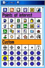
Got GPS,
Do you still have these Icons ? More? and would you be willing to post them?
http://forums.Groundspeak.com/GC/index.php...t&p=2560582
This link helped me get started , and I'm slowly creating a few in Adobe Photoshop Elements
-
Heres my Attempt at it:
Got GPS,
Do you still have these Icons ? More? and would you be willing to post them?
-
Thank you,
I'm still learning!
Only ignorant people aren't "still learning"! That's why I love the forums. I'm always learning from them.
Yep, Me too!
It's especially rewarding after my usual "Brute Force" method of learning has failed and I run across a Forum "Tidbit" that makes me feel like I was only "Slightly older than dirt" or "Denser than rock"
-
Thanks to both of you , I'm back on a roll again
The links were great information.
-
You can go to the Trimble website and download their Trimble Planning software (free).
Then you can set it up for a particular specific location, and be able to tell what all the xDOP's are for that particular location at any specific time, and which satellites are visible to your unit. You have to be sure and get the latest almanac (from Trimble site). I can tell when will be the best time to GPS a location and what and how many satellites will be visible, and which specific number birds I will be able to see, even before going out in the field.
I don't think it will identify the WAAS birds.
Using that software and a little intuition, the user could probably tell which unit is the "more correct" one.
Likely one is using a different almanac and seeing different waas birds.
Going to an "adjusted" BM location would also tell which was more accurate, but would not address the "Why" issue.
Microsoft Streets & Trips 2007---City Navigator 8
in GPS technology and devices
Posted · Edited by Grasscatcher
Has anyone seen any comparison between S&T 2007 (with the SIRFIII receiver) compared to the Garmins CN v 8 ?
Comparison of how up to date is the street info is and accuracy of routing ,etc.