


xmashl
-
Posts
41 -
Joined
-
Last visited
Posts posted by xmashl
-
-
I just got my Meridian Platnium and a copy MapSend Topo 4.20. I live in a small town on the north coast of Oregon, and the streets and POI's, so far, seem fairly accurate. However, the quality of the topographic data in the area of my hometown seem inaccurate. Most of the town lies on a narrow flat plane next to the ocean that does not raise above 25ft, however the topographic data shows the location of my home 40 feet above sea level. It also shows a 40ft contour line going into the ocean where there is a flat beach. The topography in the area surrounding the town is fairly rugged (1000+ ft. headlands).
My questions are: In general, what is the quality of the topographical data in this package? From where did they derive the topographical data? Is there any third party software out there that can offer the same functionality as MapSend Topo?
-
-
I am thinking about upgrading my GPS unit sometime soon, mostly to get a WAAS enabled unit. Currently I use a Magellen 315.
One of the features that I really like about my Magellen is that on the compass screen, it displays the position of the sun and moon, since you can plot a more accurate course than one based on the motion of the GPS unit. I've been looking through the manuals on the Garmin website, and I haven't seen any mention of a similar feature - do Garmin units have this?
-
What about all the rest? Here in the DC, MD, VA area, we have a lot of HV and JV. (with a few starting with A thrown in). Are these the initials of someone in the NGS who assigned the PIDs? Was it done by project? The number part doesn't correlate very well with the marker's age. Is there any special significance to PIDs HV0001 or JV0001, HW0001, etc.?
In my area, most of the PID's begin with either RD or SC. There seems to be no correlation to monument date from 1987 to earlier. The ones monumented in 1987 (rod types), and they may have either a RD or SC prefix. The oldest ones (1874) seem to have RD prefixes. The intersection points around here seem to have RD prefixes. There are two marks nearby that were monumented in 1991 and 1997, and these have an AA and AH prefix respectively. The prefix QE seems to be popular in my state, although theres no marks near to me with this prefix.
-
Any idea why the markers were displaced? Was the mark on private property?
-
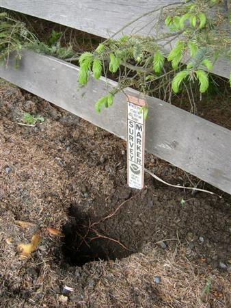
The marker is a foot away from the witness post and the fence. Perhaps it is actually under the edge of the road now. I wonder if that half lane next to the mailboxes was, at the time they put the marker in, just ground sloping away from the road. That could explain why they put it there and why it is a foot below the road. When they paved the extra half lane, they built up the slope, covering the marker. If you want to try again, my suggestion is to move away from the witness post a bit.
The tallus slope just beyond the fence for the lane that they added. It's composed of gravel and dirt, it looks like the layer is about 2-3 feet deep. I'll probably work at it little by little when I pass by it (on bike).
-
-
Well, so far I've sent a note to the guy that declared that the intersection stations attached to the peaks around the area as "destroyed".
-
Ok, what is the consensus on the best way to handle this? I went searching for benchmark RD2022, and all that remains of the station is reference mark #1, which many gc loggers have photographed and proclaimed that they found it. Should I leave it be, or send them all a polite note that the only found the reference mark?
-
I don't think you'll find much for free, but i've got to say ExpertGPS combined with broadband is one pretty dadgum cool application for looking at Microsoft TerraServer images with waypoints from your GPS. Well, well worth the price.
-
Anyone planning to come to the one at Fort Clatsop next year?
-
I'm not sure that Reference mark #1 can be found, as it would be located in the landowner's pond. LOL. Reference mark #2...maybe. We'll try to locate that.
You may also might try to locate the azimuth mark:
MD1785''THE AZIMUTH MARK IS 42 FEET S OF THE CENTER LINE OF AN E-W
MD1785''SECTION-LINE ROAD,
MD1785''14 FEET S OF A LARGE WOODEN CORNER POST, 1 FOOT
MD1785''W OF A N-S FENCELINE, AND ABOUT 0.1
MD1785''MILE E OF A LARGE RED BARN.
MD1785''THE MARK IS 6 INCHES ABOVE THE GROUND.
-
Was there a designation visible on the disk? The benchmark that you are seeking MD1785, has/had two reference markers, which have an arrow that point to the direction of the actual station. Reference marker will have arrows on them, and the station itself most likely will have a triangle in the center of its disk. If it turns out you found the reference marker, take a careful look at the datasheet, which should tell you the direction and distance to the main station.
-
I have an idea for a reverse cache. It would be similar to GCA8B7 except that you would seek a marker or a sign denoting the 45th parallel, which is exactly halfway between the equator and the north pole. This would be fairly easy find for anyone in the US that travels, as well as many other countries, especially if the southern 45th parallel is included. I myself have seen the sign on Hwy 101 near Lincoln City, OR (which would probably be the westernmost one in the US) and a sign on Interstate 5, near Salem, OR.
I would "hide" this cache myself, but I think someone with a longer history of geocaching should take this on.
-
Even though no data is published, the old records for the station its points to is probably available from NGS.
How do you go about getting the historical datasheets?
-
I found a reference marker pointing to a witness post (in an area where it is prohibited to walk due to nesting birds). The reference marker was mounted by the NGS themselves, with the imprinting YAQUINA POINT LAT STA RM NO 2. 1885 1985. The nearest marker in the NGS database is the intersection station QE2442. Do you think I should bring it to the attention of the NGS?
-
Until I learn what I'm looking for and how to find it, I'm not logging my not found benchmarks. There just doesn't seem to be a point. That's like keeping track of how often my 4 year old fails his algebra tests.
Look at it this way, say you go seek a benchmark, and from the datasheet, it's described as being on a bridge built in the 30s. When you get there, you find that the bridge has been replaced by a newer one. If you log this as a did-not-find, it will save the next person the trouble of looking for it. Some would argue you could log a situation like that as "destroyed", but there is always the slim possibility that the marker does exist in the ruins of the old bridge that may be buried nearby, or that you overlooked the ruins 30 feet down the river.
In other situations, you might just want to log your attempts to find a mark because you put the work in, and so the next person doesn't have to duplicate your effort. I logged a couple of did-not-finds for some 1874-era benchmarks, I thought the pictures of the area would be interesting for its significance to the footsteps of Lewis&Clark: RD2091, RD2083
-
http://img.Groundspeak.com/benchmark/lg/61259_100.jpg
Would you call that GOOD or POOR? The "27 S" part is readable, but the elevation is marginal.
I would call it in good condition. The condition does not refer to the marker's cosmetic condition, but if you can't clearly read the station designation, you should note that in the recovery entry.
The condition refers to the position of the benchmark in the setting. If you found the benchmark in a concrete monument, but the monument was knocked over, then it would be in poor condition, even if the disk itself has been spit polished and shined.
-
Did you enter decimal seconds in your NGS report? I see zero decimals there.
Nope, that's how I put it on the log entry. I don't have a GPSr (yet), plus in this location, there is now a six story building about 50 feet to the southeast. My reading was after 10 minutes of averaging, I could have put a more precision in the number; but without WAAS, I don't think I could confidently claim a number with more precision than to the nearest second.
At any rate, unless the landmark upon which the benchmark is monumented is washed away by a tsunami, I don't think future surveyors will have any trouble finding it from the description.
-
I just noticed some of my recently logged recoveries are showing up on the NGS datasheets. On this one, they (or Deb) left my handheld GPS coordinates in the recovery log entry.
-
If you want to label them for future inclusion in the NGS database, it's PID_YYYYMMDD_A.jpg for the closeup with the designation visible, and PID_YYYYMMDD_C.jpg for the wide shot that landmarks in context in the data sheet description.
-
That makes sense. Although I just converted my DD MM.MMM readings to DD MM SS for one benchmark (rounding off the seconds, since the NGS datasheets don't have decimal seconds), and the rounding effect was such that my readings came out the same as the ones on the NGS datasheet, even though in DD MM.MMM they were about 150-200 feet different. So unless I find a substantial difference between my readings and the scaled location, I think I'll just not include coordinates in my report.
It's not exactly true that datasheets don't have decimal seconds, for instance, this one RD1141 has 5 digits of fractional seconds recorded.
I would think that if you round to the nearest second, it should be well in the accuracy range of a handheld GPS - and a number with less than +/- 1 second of accuracy would be better than a number with +/- 6 seconds of accuracy.
-
Deb, are you encouraging us to enter coordinates into the text field of the recovery report? I always do take a reading, and I post it with my log for the benchmark on Geocaching.com. But I'm only using a consumer-grade GPS receiver and I haven't even been bothering to average the position over a period of time, so I'm skittish about having my readings show up on an official NGS datasheet.
I logged a recovery this way (SC1037), I just put the handheld coordinates on a separate line. When the datasheet was updated with my entry, I didn't see any reference to it. Not sure where it went, but I'm sure it went somewhere to be used later.
The handheld coordinates are certainly better information than a scaled position from a map (+/- 6 seconds); but if the horizontal control was determined from a surveyor's GPS, I don't think handheld coordinates would beat that accuracy, and I wouldn't bother.
-
Just curious - how much does it cost to monument a benchmark these days? I want to know for my own satisfaction how much money I saved the government by recovering a previously not found mark. Check it out: SC1037 not found twice, even though it's in plain view.

Meridian Platinum... Software Suggestions
in GPS technology and devices
Posted
See http://www.magellangps.com
You'll need a GPS to computer cable, and one of the mapsend products.