


sassmo
-
Posts
11 -
Joined
-
Last visited
Posts posted by sassmo
-
-
Oh! Thanks for the heads up! I'm fairly new to Geocaching in the area and looked for a club, but couldn't find a site. I'll definitely go there! Thank you!
-
I'm a guide on the South Fork of the American River, a Class III/III+ section of whitewater located just East of Folsom Lake/Sacramento area. I noticed that there are a lot of high terrain, high difficulty caches along the banks of the river that are usually hiked to. I think most of them can be rafted to with much greater ease. Some of them even claim to only be accessible by raft.
None of the commercial outfitters offer a geocaching trip, however, I am a guide for a commercial outfitter AND I just bought my own raft. Rafts are rather difficult to navigate with just 1 person though. Most of my friends would be bored to tears after the first cache so I want to fill my boat with people who will have fun going with me.
I have 37 caches bookmarked along a 21-mile stretch of river. I have no idea how close some of these are to the river, but I know a lot of them are fairly close to the water. There are 3 sections on this river that could be broken into 2-3 days.
My weekends get filled up with paying commercial trips, but I'm mostly free on weekdays as long as we plan ahead a week or two. Anyone want to go?
-
Woops... I guess I still have some exploring to do around the site's features as well as on the ground... Thanks for the tip!
-
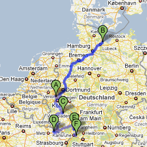
The above map is the travel route for one of my bugs (dedicated to traveling to different taverns) after it arrived in Germany. Wouldn't it be cool if our bugs had exportable Google Earth or Google Maps routes that we could open so we could get a good visual of where our bugs have been and where they're going?
-
I released three classic car TBs in separate caches throughout a local park. Their goal was to race from Seattle to my uncle's house in my hometown just outside Sacramento. A local cacher picked up 2/3 of the bugs and put them in his new cache out in the woods. His cache didn't follow the rules of the national park and it got archived.
After it got archived I emailed him about my bugs' fate. He said he'd retrieved the cache and the bugs were in his garage, waiting to go back out.
Six months later I looked at his profile, only to find out he'd been caching regularly, but never placed my bugs. I emailed him asking if he still had them. He said to be patient and that he would place them soon.
The following week, logs showed up on both bugs, one being placed in the UK and the other being placed in Denmark.
C'est la vie, I guess...
-
I've noticed that some cache owners like to keep MIA bugs logged into the cache because it encourages people like the original poster to go looking for it. That just leaves the local reviewer and the bug owner to remove it from the cache...
-
January 3rd two of my TBs were placed in a cache that was pending approval. A few days later I found out the owner of the cache improperly placed the cache in a park that has restrictions on where caches can be placed. I sent an email in February requesting the status of the TBs and he said he'd retrieve them soon. I sent another email about 2 weeks ago and another email today, requesting info. I haven't gotten a response.
What action should I take? Do you think Groundspeak would give me the coordinates for the cache so I can at least go retrieve my bugs (and possibly remove the cache)?
-
I just bought this unit on Ebay. I cleared the memory since it was full of the other user's POI's and it powered down. When I powered it back on it gave me the "Unit currently contains no maps" screen. I've seen mention of people getting to a secret screen, but nobody mentions how to do that. Can anyone offer any help?
-
I'm going to visit my mom in a few days and really want to be able to quickly upload coordinates so I can take her caching in her area. Is there any way to upload waypoints via a Mac?
If not, what's the best way to upload waypoints to a Geko 201 via a PC? I can access her PC when I get there.
Sorry if this is a repeat topic, but I searched and couldn't find anyone who's already asked this question.
I have a Garmin Geko 201 and a MacBook. I have the serial cable to USB converter and I've been able to download waypoints from the GPSr, but I haven't been able to upload. Has anyone been successful in uploading waypoints to a Geko 201 with a Mac? What programs did you use?
-
Sorry if this is a repeat topic, but I searched and couldn't find anyone who's already asked this question.
I have a Garmin Geko 201 and a MacBook. I have the serial cable to USB converter and I've been able to download waypoints from the GPSr, but I haven't been able to upload. Has anyone been successful in uploading waypoints to a Geko 201 with a Mac? What programs did you use?
Survival stories?
in Hiking/backpacking
Posted
This isn't really a survival story, but it is about a bad situation we got into while backpacking and caching... This is also for a log post that I wrote, but reached max length and couldn't post and didn't want to waste, so I found this topic.
In April of '09 I was invited by R, a fraternity brother from the University of Hawaii, to join him on a 3 day backpacking trip in the Henry W. Coe State Park. R planned on doing about 30-35 miles in 3 days. Having seen some of R's photos from previous trips (ie. 14 days on the Pacific Crest Trail), I knew the trip would be extremely strenuous and to pack as conservatively as possible.
I invited my best friend from high school, M, who is a CalFire HeliTack Firefighter and former Boy Scout.
When we got to the trailhead the next morning, I could see the worried look on R's face as M put his pack on, then strapped Web Gear to his waist, but M assured us he could handle it given his profession and Boy Scout experience. R questioned me about any non-necessities, but the only ones I had brought were a GPS and a few trackables.
On the map, there was a few caches in the first two miles and then no more until well into the following day.
Two miles into the hike, M was hurting. By lunch he was broke off. It turned out after lunch most of the rest of our hike until we made camp would consist of 6 miles of near vertical old Jeep trail until we hit a ridgeline.
As we creeped over the top of the ridge to flat ground, the wind started picking up and ominous looking clouds started rolling in. Our camp was supposed to be at a spring about 1/2 a mile down a draw, on a minor trail about 2 miles down the ridgeline. We found what looked like an old unmaintained trail but weren't sure if it was a trail or deer run so we kept going. After about another 3 miles we finally made camp in a clearing on top of a ridge.
That's when M opened his pack and to our surprise he pulled out what looked like a loaf of bread wrapped in aluminum foil, but was actually a sort of hobo stew made of potatoes, onions, bell peppers, etc. Then he pulled out his .45 and 2 boxes of rounds, "in case there were any nasty critters that wanted to visit our camp in the night." He also pulled out a pair of giant, old Bushnell binoculars, a 5lb glass jar of honey, a whole squeeze bottle of mustard, and enough trail mix to feed all of us for 3 days.
By the time camp was set and dinner was in our bellies it had started to rain and the wind had picked up. By the time we crawled into our tents the wind had grown into a howl. Throughout the night you could hear the gusts of wind as they gained speed, "....wwwwwwwwssssssshhhhhhHHHHGGGGHHHHH" and then the tent pole would collapse and the nylon sidewall would slap us across the face. If we had made the extra effort to find the other camp we would have been in a wooded draw on the East side of the ridge, protected from the Westerly winds.
The next morning was a somber one, since none of us had slept much, we were slightly damp because of the rain and we were low on water with no streams nearby. After turning on a cell phone and calling R's Mom, we found out the forecast was intermittent sprinkles and rain during the day, and more storm and possible snow for the evening. We decided to cut our trip short and make the short loop back to the car - it would still be at least 12-14 more miles though.
After hiking down the ridge down into the valley, it was time to boot up the GPS as we were nearing a few of the available caches. It was then that I discovered the topo map on my GPS included the trail we had missed the night before. C'est la vie. At least we camped 3 extra miles farther down the loop than we had planned.
We hiked out, stopping regularly to Geocache, rest our feet, and eat as much of M's extra food as we could. I found 8 caches in all and got a bad case of poison oak (which I generously shared with many of the other residents of our apartment complex who like to use the hot tub ).
).
...And the morals of the story are: 1) Make sure everyone knows how to pack their pack, even if they say they know what they're doing; 2) Check the weather forecast before you go; 3) Never underestimate the power of your GPS's topo map; and 4) Even though you're not usually prone to poison oak, Tecnu is still a good thing to use.