


LSUFan
-
Posts
656 -
Joined
-
Last visited
Posts posted by LSUFan
-
-
Thanks. I saw a bunch on the Capitol, but just a few close to the White House, using Scaredycats viewer. I figured that they must be marks not necessarily listed in the NGS database.
-
Looks like 42 on the White House...
That is extremely interesting. Is there an online source that shows them?
All I knew about was the Zero Milestone, located near the White House.
-
Even those reports appear to be duplicates, because the datasheets show two identical reports for each of those PIDs.
Hmmm, I have been using DSWorld to send in HH2 coordinates and to upload pics. I wonder if that is why there are two reports, but I don't recall that happening before as I have used DSWorld for awhile now.
I also noticed something else on the NGS site. When I was looking at the monthly archives, there doesn't seem to be an update for the states since July........and Louisiana isn't even listed anymore (I wonder if it was something I did
 )
) -
I bet that LSUFan will be in shortly with a link to a tutorial that he has written.
That's Mike putting the pressure on me. LOL
Yes, the 'me first' topic is great, as is the pinned topic by George about the triangulation stations.. Jennifer also has a good beginners guide on her site:
http://surveymarks.pbworks.com/w/page/14246997/FrontPage
I took a lot of different info from all the great people here and kinda combined it into intro topics on our local geocaching forums which are pinned here: I would advise to read the first 5 forums that are pinned....especially the part about scaled vs adjusted coordinates. Copies of George and Jennifers tutorials are included in these five.
http://www.nelageo.net/index.php/forum/13-benchmarking-and-related-topics
Welcome to the fun, and feel free to ask (and I personally ask a LOT) questions as you need. Everyone here is great and will go out of their way to help you.
-
What town is he in?
I bet it begins with a V.
I think that's how the mountain towns note what town it is to airplanes and travelers, you can see them a lot easier than something down on the ground. Cool BM
Virginia City, Nevada
-
One of my good friends is on vacation out in Nevada. He just called me and told me to look at a unique benchmark he just logged. Can't say I have seen one like this before.
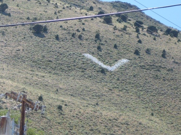
http://www.ngs.noaa.gov/cgi-bin/ds_mark.prl?PidBox=kr1649
KR1649'DESCRIBED BY COAST AND GEODETIC SURVEY 1951 (LGT)
KR1649'THE STATION IS LOCATED ON THE EAST SIDE OF A HILL ABOUT 1/2
KR1649'MILE WEST OF VIRGINIA CITY. IT IS A LARGE LETTER V MADE OUT
KR1649'OF WHITE WASHED ROCKS.
KR1649'
KR1649'THE UPPER LEFT-HAND EDGE OF THE LETTER WAS THE POINT INTERSECTED
-
And we seem to take at least 2 shots of each mark we find plus if it is Tri-station, one more of each RM and a view shot of each. We do not normally take pictures at caches unless we have a TB/GC to move along or some special cool scenery shot.
So, just how many pictures have you taken?
I will accept rough estimates.

Shirley~
--------------------------------
Hmm, that one is hard to answer. I took nine shots of this Tri-station Saturday, but do average 2-3 per standard benchmark.
I'll have to get back to you
-
While USGS never officially submitted their data for inclusion in the NSRS, NGS does maintain a nearly complete collection of their old horizontal and vertical control data. The positions that they determined for mapping purposes are of at least third-order accuracy and certainly better than the scaled values.
Dave, that's extremely interesting. If I'm understanding correctly, the USGS didn't really do anything specifically to get their information into the NSRS..... but it was the NGS who really "bluebooked" all the USGS marks that are in the NSRS?
For some reason I thought that the other agencies, after meeting the NGS bluebooking requirements, sent their info to you to be specifically included in the NSRS. Now, I see where you even do more things behind the scenes. It's like I said before, you are a ninja.

-
Nice article, thanks for the link. Seems as good a place as any to plug a geocache AZcachmeister and I hid last month, GC2WCPX Signalman Jasper S. Bilby.
Now that is one good cache write-up. Sounds like a great geocache (Expect to spend the better part of a day reaching this location).
Putting it on my bucket list and placing a link to it in our local geocache forums.
If that ftf prize is the geocoin I am thinking it is, I am already jealous, as I stated in a previous forum how I wanted one.
-
Andy, you didn't get the top-secret memo DaveD sent out to us about this? You must have been away for awhile.
Seriously, I have been seeing a lot of local marks getting updated HH1 coordinates, with many of these being reference marks for triangulation stations. I am assuming that since the stations had adjusted coordinates, that you could use computer programs that will give you accurate numbers from the measurements and compass directions to achieve this.
However, this is just a guess on my part, and I'm sure we'll get the low-down shortly.
-
I was sending in recovery reports today, and was going to send an email to Deb about BW1564 being destroyed. I happened to look at the datasheet for it first, and see where Dave Doyle (I assume those are his initials on the report) has already marked it as destroyed.
I'm going to start calling him Ninja Dave, cause of how silently and fast he operates.
I bet he can even throw disks like other ninjas throw stars.
-
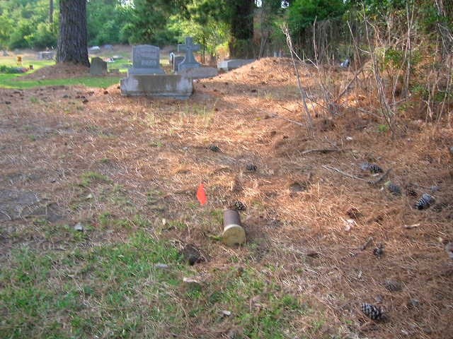
Excel on the way. Note posted in COE Quandaries string. kayakbird
I got it Mike, and will start looking at them hard. We plan to get back over near the MS River and look for several older ones there.
I did manage to get East Carroll Parish turned from white to blue yesterday, for Jim's map purposes with CP3384 and CP3386, which just happened to pop out on us as we were pulling off the road to do some reorganizing. Funny stuff like that happens.
We also found a newer disk DG4769 (2002) by accident as we were heading into Lake Chicot Park. Our Nuvi dinged and there it was on a concrete culvert. It's apparently an Army Corps Height Modernization Survey Station disk, monumented by (I'm guessing, a surveying company but am not sure)
-
Is it too late to send you 50+ SP#18/PID correlations? MEL
I'm still here, what have you got?
hktire@aol.com
-
Oops! Here's what I found in the datasheets:
CQ3410 HISTORY - 20110417 MARK NOT FOUND GEOCAC
...
CQ3410 STATION RECOVERY (2011)
CQ3410
CQ3410'RECOVERY NOTE BY GEOCACHING 2011 (BKT)
CQ3410'THE AIRPORT HAS BEEN TORN DOWN AND CONVERTED INTO PUBLIC SOCCER
CQ3410'FIELDS. THE AZIMUTH MARK COULD NOT BE LOCATED AND IS PRESUMED TO BE
CQ3410'DESTROYED WHEN THE ASPHALT WAS REMOVED AND THE GROUND LEVEL LOWERED TO
CQ3410'ACCOMMODATE THE SOCCER FIELDS THAT NOW SIT ATOP IT.
[/font]
That recovery goes to CQ3409. I can't believe I crossed them up. I will wait till the datasheets show up to see.
I checked today and it seems that the NGS has posted a lot of recoveries. CQ3410 is listed as a not found. Evidently I either reported it wrong, or as I have now noticed, my actual recovery report in itself seems to state it is a not found (even though I was just referring to the azimuth mark part of the triangulation station).....which I also should have clarified more. Maybe the big guy, DaveD, will see this and fix my error. I did post a pic of CQ3410 with DSWorld which has been added to the datasheet.
I also got a bone to pick with Jim. That white parish in the northeast corner of LA (East Carroll) that shows up on his map keeps annoying me so. I may have to go up there today and color it in........then if I'm that close, I'll just have to drive on up to southeast Arkansas and pick up a hiking stick medallion, while doing the Arkansas State Park Geocache Challenge at Lake Chicot..........I really don't have time for this as that would take up my whole Sunday, that I need to be out mowing and doing yard work. So it's all Holograph's fault.
-
Cool. I never knew that's what they were called. Sure needed some in front of my shop a few years ago when that kid hopped over the curb (which he blew his tires out on), and ran up into it.
When the cops caught him on down the road (yes, he backed out and ran off)with his flat tires, he told them he didn't realize he had ran up into the building. He then tried to spin it to his parents insurance company that it was my fault for not having the curbs set far enough back to keep him from going into the building.
Maybe if I had some bollards set, it could have saved this kid a lot of lying.
-
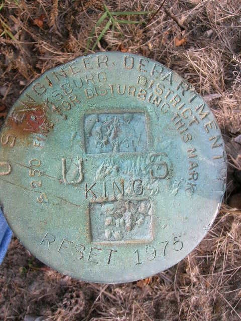
LSUFan,
Is there any chance that your UNK date
BW1603 HISTORY - Date Condition Recov. By
BW1603 HISTORY - UNK MONUMENTED DOD
BW1603 HISTORY - 1934 GOOD DOD
cap & bolt pair may be one of these? Have you found any of this style that are dated?
from Special Pub #18:
NOTE 60.-A type of bench mark set by the U. S. Army Engineers. It consists of a concrete slab
16 by 16 by 4 inches set about 3 feet in the ground. A copper bolt is embedded in the concrete
slab, which is also surmounted by an iron pipe 4 inches in diameter and 4 feet long with a cap
bolted to its top. The center of the cap is directly above the bolt in the slab. Elevations are
usually taken on both the bolt and the center of the cap.
And I'm guessing that what they mean by 'RESET' is just re-plumbing the pipe over the underground mark -
similar to what the IBC calls 'RENEWED' along the Canadian border. Many of such IBC's do not have DATASHEET history.
I don't think that SP Pub #18 has a level run that may have tied to this line - but I didn't look very hard.
kayakbird
Kayakbird, I have found several of this kind. I have noticed a lot of the times that the description for the bolt (which is underground) also is the same as for the cap. It's like they copied the same thing for the cap (surface) and bolt (subsurface) when they entered them onto a datasheet/database. However, they do list them like below too:
This is from a cap & bolt pair I found and submitted a recovery on. The HH2 coordinates and pics I submitted have been added to the datasheet, just waiting on the actual recovery report to show.
http://www.ngs.noaa.gov/cgi-bin/ds_mark.prl?PidBox=CQ0974
http://www.ngs.noaa.gov/cgi-bin/ds_mark.prl?PidBox=CQ0975
Now as far as a placement date being shown on one of these kind of caps, I can't say I have seen one yet. Let me go back and look at my logs to see.
-
We ran into a few things this weekend while looking for benchmarks south of our usual territory. There are a lot of US Corp of Engineer cap and bolt pairs, placed in this area in the 30's, which most don't have any recoveries on. A benchmarkers paradise you could say. LOL
Our first situation, arose on BW1603, which is a cap named KING from 1934. We found (a) KING cap from the datasheet description, but it had been stamped that it was reset in 1975. Any ideas on what happened here, or how (if) it should be logged with the NGS? I just logged it as a note on gc.com.
http://www.geocaching.com/mark/details.aspx?PID=BW1603
Our next situation happened at BW1564 which is a cap named SONES, also from 1934. There is no doubt we found the correct cap here, that was in the weeds, but it was attached to a broken off piece of pipe. It is destroyed. I thought about taking the cap, and trying to return it to the Corps, but didn't know if I really should. I'm not sure if the Corps are as friendly with us as the NGS is. Any advice on what (if anything) should be done about this, besides reporting it to Deb as destroyed for NSRS purposes.
http://www.geocaching.com/mark/details.aspx?PID=BW1564
Thanks
-
Oops! Here's what I found in the datasheets:
CQ3410 HISTORY - 20110417 MARK NOT FOUND GEOCAC
...
CQ3410 STATION RECOVERY (2011)
CQ3410
CQ3410'RECOVERY NOTE BY GEOCACHING 2011 (BKT)
CQ3410'THE AIRPORT HAS BEEN TORN DOWN AND CONVERTED INTO PUBLIC SOCCER
CQ3410'FIELDS. THE AZIMUTH MARK COULD NOT BE LOCATED AND IS PRESUMED TO BE
CQ3410'DESTROYED WHEN THE ASPHALT WAS REMOVED AND THE GROUND LEVEL LOWERED TO
CQ3410'ACCOMMODATE THE SOCCER FIELDS THAT NOW SIT ATOP IT.
[/font]
That recovery goes to CQ3409. I can't believe I crossed them up. I will wait till the datasheets show up to see.
-
There were 2 datasheets updated with new GEOCAC recovery logs. The most recent recovery added to the datasheets was dated April 17. The two "not found" recovery reports were for CQ0073 and CQ3410 in Louisiana by LSUFan. What is interesting is that when I pull up those datasheets online, the recovery reports are no longer there, at least as of the morning of June 4. Perhaps the NGS is having problems with their system.
That doesn't sound right, at least for CQ3410. I found that one and submitted the photos for it using DSWorld. You can see this by the naming scheme of the photos, which I also used on my gc.com log. I will go back and find my notes on when I submitted them, which is all at home (I'm at work). Hopefully I didn't report that one as a dnf to the NGS......now I'm worried

-
Dang, you are going to make me want to get rid of my bagphone and get an android now.
-
Kerry, I sent it to you, but it got kicked back as an illegal file. I zipped it the next time and sent it again.
-
TillaMurphs, probably the easiest way to get you going right now is to just email you the program file, as it's only around 2mb. Just pop me a line at wmtire@yahoo.com so I can get your email address, and I'll attach the program to an email and send it right back to you.
We can then troubleshoot your problems after the fact, but you can be using the program in the meanwhile.
Bobby
-
I tried it with IE9 and Chrome on one computer and IE8 on another computer - no luck:
I get this:
IE9:
Internet Explorer cannot display the webpage
More information
This problem can be caused by a variety of issues, including:
•Internet connectivity has been lost.
•The website is temporarily unavailable.
•The Domain Name Server (DNS) is not reachable.
•The Domain Name Server (DNS) does not have a listing for the website's domain.
•There might be a typing error in the address.
•If this is an HTTPS (secure) address, click Tools, click Internet Options, click Advanced, and check to be sure the SSL and TLS protocols are enabled under the security section.
Chrome:
This webpage is not available
The webpage at http://ngs.tsqmadness.com/help/index.html might be temporarily down or it may have moved permanently to a new web address.
Here are some suggestions:
Reload this web page later.
Error 101 (net::ERR_CONNECTION_RESET): The connection was reset.
I think it's going to be just a setting. First, let's clear your cookies and see what happens. Here are some how-to's on that:
http://kb.wisc.edu/helpdesk/page.php?id=15141
http://www.google.com/support/chrome/bin/answer.py?hl=en&answer=95647&from=95626&rd=1
Also, since you are having problems on two computers, are both of these computers accessing the internet thru the same location and/or router? If so, I believe it's going to be a firewall problem....or possibly the HOSTS file.
-
Yep - I can't get that link to work using Internet Explorer or Chrome. Does it work for you?
Thanks,
Yeah, it just worked all the way for me using FireFox 4. Exactly what is it doing (or not doing I guess)? Does it let you download, the won;t open, or just won't let you download period (which could be a security setting you have set)
 )
)

Photo naming document?
in Benchmarking
Posted · Edited by LSUFan
Mike, a little more clarification on the naming schemes
The photo numbers of 1,2,3 (or more with earlier releases of DSWorld) that come after the marks name, are specific to the view you are capturing.
You will use the number 1 when it's a closeup pic of the mark
You will use the number 2 when it's a tripod height/eye level pic of the mark
You will use the number 3, then add the compass direction initials you are facing, when it's a horizontal/scale pic of the mark.
With earlier releases of DSWorld, you could just keep using higher numbers of 4+ for each scale pic you submitted. However, it seems with the latest release that every scale pic is going to have only the number 3 and compass direction with it.....even if you took 5 scale pics, they all will have the number 3 in the name.
I also talked to Malcolm about why DSWorld will actually name the pics one way, but change the order of the PID/Name on the pic when you use the software to put a stamp on the pic itself. He said that was the way NGS wanted it.
So, to make it simple for naming the actual jpeg photo. It needs to be the
1.PID# (then a dash -)
2.mark name (use underscores_ for spaces in the name)(another dash -)
3.number of photo (1 for closeup, 2 for eye level, or 3 for scale/horizontal...if it's a 3, then you also need the compass direction following (N,S,E,W,NE,NNE, etc) then (another dash -)
4.Date photo taken (YearMonthDay all together, no spaces)
Here are some examples: I use DSWorld to name the pics for me as well as stamp them for me......and use the same named photos for geocaching and NGS recoveries now. You can see the name of the pics and when you click on them, you can see how the stamp has the PID/Name order reversed.....but that's what DSWorld does. Also, I didn't take a tripod/eye level pic of the mark, so there is no # 2 pic
http://www.geocaching.com/mark/details.aspx?PID=BW1569
http://www.geocaching.com/mark/details.aspx?PID=DK0988
Using DSWorld (or manually doing them in the NGS format) to name the photos does make it a lot easier to go back and look them up again on your computer. You can instantaneously look at the name and know what it is.