


LSUFan
-
Posts
656 -
Joined
-
Last visited
Posts posted by LSUFan
-
-
With the recent discussion on these I went to look for one. Not sure what I found.
Clicky link > TR1852
Any thoughts would be appreciated.
I don't think it was the 'airway beacon'.
How is a surveyor up in a Bilby tower going to sight on a concrete arrow in the ground?
My thought is that the arrows were sometimes installed as daytime assistance, but the beacons were really intended for nighttime navigation.
I agree with AZcachemeister. Even though the datasheet doesn't actually specify what the intersection station is, a concrete marker on the ground doesn't really fit the normal definition of an intersection station, but there are always exceptions:
Intersection Stations (a Type of Horizontal Control)
An intersection station is a prominent landmark, such as a water tower, radio tower, church spire, mountain top, or any other type of object that can be observed from a distance. These kinds of "large object" station markers, known as intersection stations because of the way their coordinates are calculated are usually landmarks higher in the air than any surrounding objects, which allows them to be seen from many miles away in several directions. By observing one or more such points through a telescope, surveyors can determine positions on the surface of the Earth through the use of trigonometry.
I have actually been looking for some airway beacons intersection stations in LA as of late, and all of them were supposedly on top of towers.......as I assume TR1852 was too. A concrete airway "marker" is different from an airway "beacon".....even though they sound alike. I've always assumed that a beacon is a lighting fixture. We've been talking about some beacons in this forum (which is what got me interested in them):
http://forums.Groundspeak.com/GC/index.php?showtopic=282088
EDIT: Tillamurphs, I did some more research and found where Airway Beacon #9 TR1823 has been destroyed. However using that datasheet, you can see that even though it's initial report doesn't list the beacon being on a tower (just like the datasheet for Beacon #10 TR1852 from the same time frame)....you can see from it's subsequent reports, it was the beacon atop a tower:
TR1823_U.S. NATIONAL GRID SPATIAL ADDRESS: 10UEV3440904623(NAD 83)
TR1823
TR1823 HISTORY - Date Condition Report By
TR1823 HISTORY - 1941 MONUMENTED CGS
TR1823 HISTORY - 1947 GOOD CGS
TR1823 HISTORY - 1950 MARK NOT FOUND CGS
TR1823 HISTORY - 1950 DESTROYED CGS
TR1823
TR1823 STATION DESCRIPTION
TR1823
DESCRIBED BY COAST AND GEODETIC SURVEY 1941 (JCS)
STATION IS LOCATED ON THE W SIDE OF THE BELLINGHAM - FERNDALE ROAD APPROXIMATELY 4 MILES NW OF BELLINGHAM, WASHINGTON.
TR1823
TR1823 STATION RECOVERY (1947)
TR1823
RECOVERY NOTE BY COAST AND GEODETIC SURVEY 1947 (RGH)
DESCRIPTION ADEQUATE.
TR1823
TR1823 STATION RECOVERY (1950)
TR1823
TR1823'RECOVERY NOTE BY COAST AND GEODETIC SURVEY 1950 (CWC)
THIS STATION, LISTED IN THE LIST OF GEOGRAPHIC POSITIONS NO. G-5410,SEATTLE TO BELLINGHAM, AS AIRWAY BEACON NO. 9 1941 WAS RECOVERED IN CONNECTION WITH PROJECT PH-26 (47) IN 1949. A RESUMPTION OF THIS WORK IN 1950 REVEALS THE FACT THAT THIS TOWER WAS BLOWN DOWN ON JANUARY 13, 1950 AND THE STATION DESTROYED. NO CONCRETE FOOTINGS REMAIN AND THE HOLES LEFT BY THE TOWER LEGS WILL SOON BE UNRECOGNIZABLE.
TR1823
TR1823 STATION RECOVERY (1950)
TR1823
TR1823'RECOVERY NOTE BY COAST AND GEODETIC SURVEY 1950 (HJB)
THE BEACON TOWER WAS BLOWN OVER BY A STORM IN JANUARY 1950. THE AIRPORT OFFICIALS HAVE NOT DECIDED ON WHEN OR WHERE IT WILL AGAIN BE ERECTED. A NEW SITE IS BEING CONSIDERED.
Legacypac and 2sly4u may have laid a goose chicken egg on this one, looking at their logs.

-
Also, I've wondered whether the particular satellites overhead at a given time might be a factor, i.e. at noon on Tuesday I could get a good fix, but not on Friday at dawn. GPS satellites are not geosynchronous, so the subset of the total constellation is in view now might be more favorable than those in view at another time.
-ArtMan-
Artman, you are correct. The number and position of the satellites (the "constellation") make a big difference in the signal. Has anyone ever noticed that at times you get great accuracy and other times, even though you are "outstanding in your field" so to speak, you can't seem to get a good signal. Well it all has to do with the constellation--what satellites are visible and high in the sky. GPSWorld discussed this in 2009 There are calculators for determining the best times to get GPS readings. Trimble has a downloadable one.Navcom has an online one. I am sure there are others out there.
Edit: found an even cooler one (through a link on the John Deere site). http://navcomtech.com/Support/Tools/satellitepredictor/main.cfm
Thanks for that link, mloser. I just bookmarked it. Not trying to get off topic too much, has anyone here had much experience with the Russian GPS system (GLONASS)? I've been reading where a lot of the smartphones can use our and their systems......as well as some units able to read both at the same time. I was just wondering how accurate of a reading you could get utilizing both systems at the same time.
-
Sorry LSUFan - a bit late on reading your post. However, that picture appears to belong to: EZ0760 in North Carolina.
Thanks for finding out where Garner is. It's a good ways from Louisiana.

I am just guessing, that it is some kind of data entry error, for the reason those two disks are showing up in the photos for Louisiana's COP.
-
http://i52.tinypic.com/w1fjmw.jpg
http://i53.tinypic.com/2h8046f.jpg
I was out for a bike ride today enjoying the fall colors. On the side of the road, Alder Bend Road in NY, was a witness post. Very close to the post was this benchmark. I can't find any information in the database. Can you submit information for a benchmark that isn't in the database? If so which agency should it be reported to? GPS'r coordinates were N44 50.559 W073 43.919. The wierd part is that I have been down this road a hundred times and never noticed the witness post. I guess I should get out and go for more bike rides.
If the mark is not in the NGS database (which is what gc.com has on their website, or actually a copy of from around the year 2000)......then you can log it in the benchmarking category of Waymarking.
http://www.Waymarking.com/cat/details.aspx?f=1&guid=424f2581-a02d-4914-9bc8-8f4cafe02680
-
Hello,
I have converted a few data sheets into gpx files by copying into a txt file and converting with NPS>>GPX and then loading them into GSAK. Compared to gc.com's coordinates the converted data sheets would appear to be more likely to be accurate. Is this true, or can they be just as far out as gc.coms?
thanks,
Mr Kaswa
The first thing you need to understand about benchmarks is if the coordinates listed on the datasheets are "adjusted" or "scaled". Adjusted coordinates will be precise, even more so than your handheld gps unit. Scaled coordinates can be off as much as 600+ feet.
Here is some reading on that subject.
http://www.geocaching.com/mark/default.aspx#adjscl
-
Any and all details of how you're using POIs on a Garmin GPSr would be most appreciated!
Patty
Patty, if you are a GSAK user, then it is easy to do after a little initial preparation and learning curve. Garmin has it's own piece of software called POI Loader for placing poi's on its units. However, you first must take the datasheets, and get them sorted to your liking....which is what GSAK can do.
This forum below is about placing benchmark POI's on the Garmin Nuvi......but CallowayMT also placed them on his Garmin 62, and he might can answer your questions concerning a Garmin handheld instead of the Nuvi.
And yes, these benchmark poi files store the entire datasheet (at least on the Nuvi).
http://forums.Groundspeak.com/GC/index.php?showtopic=267951
From what I have read on the Garmin site, I believe you can load just a direct gpx file into the POI loader software and make your own. You might can bypass GSAK all the way.I bought my son a Garmin Dakota a few months ago. I will play with it some this weekend and see what it takes to put the datasheet poi's on it......and if I can do it without GSAK in keeping all the datasheet information intact.
-
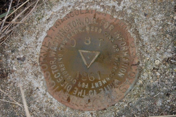
Was that disk set in 1961, or am I reading it upside down?
Jim, you dog. I caught myself turning my head to see the if the numbers were upsid..............then just started laughing. My mind is working real slow this Friday afternoon.
-
- walk to where your gps tells you to go - either it is there, gone, or replaced by a clearly newer tower.
Hope this helps.......... and if you find one.........................
Ok, I am firmly placing the blame for my obsession for finding one of these on you now, frex3wv.

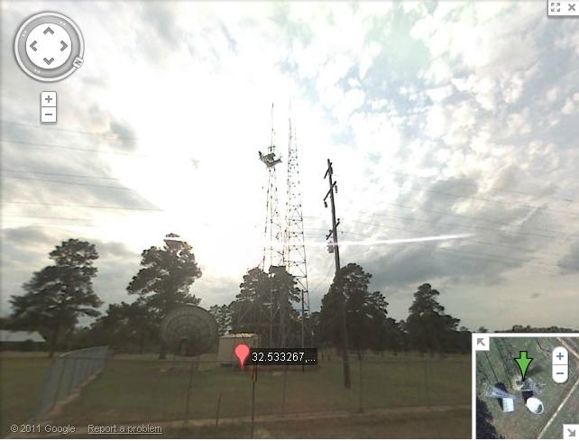
When I look at CQ3244 on google maps, I can see a four-legged tower, and it looks real similar to the ones in the history links provided. However, there also seems to be more mast above the platform, which I guess could have been added later. I will be over that way in a few days and take a looksee. It is all fenced in, so I won't be able to get but so close.
-
OK, all this talk about old airway beacons got me curious as I have seen some datasheets for them before in my local area. Normally I don't do many intersection stations, but the history of these was too tempting.
I used GSAK to filter them out and it appears there are about 5 of these old airmail route ones still listed in the NGS database for LA, and they are all on the Ft.Worth to Atlanta route, which passes right over me.
I used google earth/maps to see if I could see any structures but couldn't decide on what I was viewing on a few of them. I happened to be near three of them today........and you just know I had to take a personal gander (wouldn't you?).
None of the three were there (and I didn't really expect them to be). There is one that maybe is there. It is further west, but I will be that way later this week to check, and the power squadron submitted a found recovery report on it in 2003. The satellite view and street view show a three-legged tower, so this may not be a true one.
I now need to say it's all frex3wv's and EdrickV's fault.
-
If memory serves me right, this has happened in years past, in the summer months. Since I work across the street from them, I COULD run over and pester, but I'm pretty sure the reasoning has to do with summer months and kids out of school. People take off of work, so less hands to do the work needed..
Of course, since I DON'T go over there and pester Dave or George that often.. they may be doing it on purpose, just to see how long it takes before we say something about it.

Maybe, they're off doing ninja training.
-
Thanks southpawaz. I am 99.9% percent sure this LOT is not there anymore. It is almost across the road from where you park to access the trail to Mount Driskill (the highest point in LA). As many times as I have went up Driskill with geocaching friends, I believe I would have noticed a fire tower nearby. I think there are just cell phone towers there now, but will definitely make sure the next go around. I think I looked one time, but may be confusing this with another one.
I might be able to search for the Gentry triangulation station though, depending on if there is access. It's probably fenced off.
-
Per the data sheet:
CQ2886.The orthometric height was scaled from a topographic map.
Is it safe to assume they took the elevation of the base of the LOT on the topo map, and didn't add the 80 foot to it......and/or does the term orthometric tie it to the surface of the earth?
Thanks
-
As usual, when Jim/Holograph posts his monthly statistics, after I look at the maps, I seem to always end up looking at the extreme stations while on his site.
I keep looking at the highest elevation benchmarks for Louisiana, and noticed something today that I haven't really studied........so I brought my questions to the experts here.
The highest benchmark in LA is the Gentry LookoutTower CQ2886 and the point intersected is the TOP CENTER OF A 6-FOOT SQUARE CABIN SUPPORTED BY A 4-LEGGED STEEL STRUCTURE WITH AN OVERALL
HEIGHT OF 80 FEET. It's scaled height is 512 feet. It has adjusted horizontal coordinates.
Now the second highest point is Gentry triangulation station CQ2887
This station is down on the ground near the Gentry LOT. However it's elevation (vertcon)is 511 feet....or one foot less than the 80 foot high Gentry LOT
In obtaining the elevation for the Gentry LOT, would they have just measured the ground level that the LOT sits on? I don't guess I have enough experience with intersection stations to have ever really looked at how the elevation information is derived for them. I just thought it was real curious the there was only 1 foot difference between the two........even though one of the points is 80+ feet above the other.
I'm just guessing that difference is because the LOT has scaled elevation numbers (which just coincidentally put it within a foot heighth of the other), but would welcome any guru knowledge about this. Thanks
-
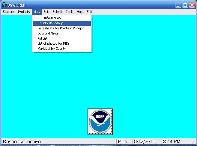
John, using DSWorld...... clicking "Stations", then Published, By State & County (Beaver County, UT)....I see what you are talking about. Those two lines run way down into Iron County.

-
John, do you use the current version of DSWorld? It has a way to submit correct state/county listings to the NGS
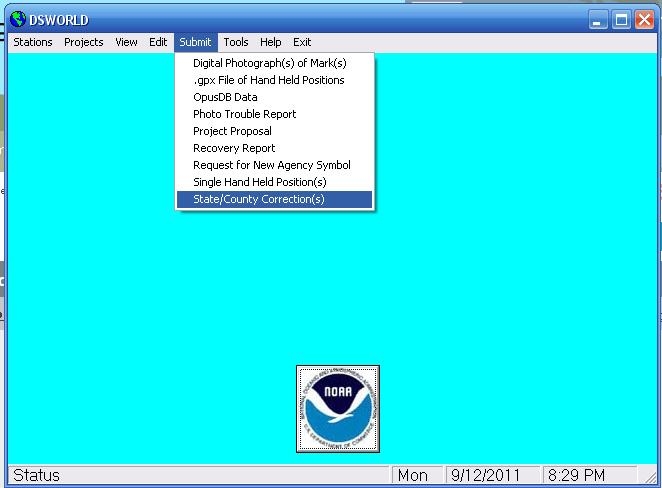
You can also use DSWorld to see the counties on Google Earth, and get lists of all the NGS marks listed for each county....to check and see if they are correct.
-
ooops - should have been more specific - I am looking for paper maps - the larger the better.
A local store that sells surveyor supplies/equipment may also have the 7.5 minute topo quad maps for purchase. I think they are 22" X 27" and 1/24000 scale.
We have a supply store like that here in Monroe, LA that sells each quad for the entire state of Louisiana. They're all in drawers (like a tool chest), that you pull out the drawer and get the map.
You might can look in the phone book under "surveying" to see if there is a store that sells supplies nearby and give them a call.
-
Thanks everyone, for the responses.
-
And btw, what is the protocal about logging a benchmark find. Just factual? Not writing some longwinded thing about how I almost got flattened by a car when I crossed the road, or the knock a buzzard over smell of the dead skunk in the ditch?
On GC.Com logs, I think it is OK to say whatever you want. If you have an experience that deserves telling, I tend to believe that all of your fellow benchmarkers would like to read it.
Ex: "and the smell was so bad that it would have made a skunk commit suicide"
Now if you log with the NGS, just factual.........and in the same terminology as you read on the actual datasheets.

-
Most of us have found that Power Squadron logs recovery notes should (almost always) be viewed with a jaundiced eye.
I'm heading out of town this evening for a football game, and plan to check on one tomorrow that I hope the Power Squadron couldn't find (2 different times). I think I may be seeing the actual benchmark from 1919 on the side of a building using Google Maps/streetview ....but can't tell for sure. I will know tomorrow if I can correct (or agree with) their assessment.
-
There used to be a pdf benchmarking explanation sheet (similar to Geocaching University) that kinda explained what you were doing to landowners. I downloaded this and had many copies printed out.....but can't for the life of me remember where I got it. Maybe others here can point it out, and you could add it to your presentation.
-
I know all the government agency acronyms can get confusing too.
The USGS (United States Geological Survey) and the USC&GS (United States Coast & Geodetic Survey)are two different agencies.....but almost have the same letters so you have to be mindful of them.
The USC&GS is what is now the NGS (National Geodetic Survey) and is the database we use on geocaching.com. Here are some links to both of them, and helps explain their different functions and purposes.
These links are great reading (when you have time)......explaining the NSRS (more acronyms) and the history of the USGS (many pages)
http://www.ngs.noaa.gov/web/about_ngs/history/
http://celebrating200years.noaa.gov/foundations/spatial/welcome.html
-
and you can see that it is a usgs benchmark, not in very good shape though. So now what do I do?
BlueMoth, welcome to the world of benchmarking, and congratulations on wanting to get it all correct. There is a little learning curve, but you will get it.
Your question is probably the most common one in these forums (I asked it myself). Hopefully, the following which is copied from the benchmarking FAQ's will help....including on what to do with USGS disks not listed in the NGS database:
http://www.geocaching.com/mark/
Benchmarks Not in the Database
I found a benchmark, but it isn't in the database. Why?
To answer this question, you need to understand a bit about what "the database" is. The database used by Geocaching.com is a copy (from around 2000) of the database that NGS maintains. Although the NGS database has lots of marks in it, it does not have them all. In order for a mark to get into NGS's database, it has to go through a process known as "bluebooking" which ensures the disk meets the minimum requirements to be of geodetic quality (aka the highest quality possible). The NGS is not the only organization that creates and uses benchmarks and other types of control markers. In order for any mark to get "in the database" they must be "bluebooked", which can take a lot of time and effort and is often not done to save money. Remember, even though some marks might not be in the database, they are still highly important, both to businesses and to individual citizens such as your neighbors, so please treat them with respect, while enjoying the thrill of the hunt. We'll try to find other databases and add them to the site as well. If you have access to one of these databases and would like to submit it to Groundspeak, contact us.
Since the Groundspeak benchmark database was obtained from the NGS in the year 2000, newer benchmarks and recent reports on older marks will not be visible here in Groundspeak's copy. Besides new disks, there are many cases of benchmarks monumented significantly before 2000 but entered the NGS database only after the year 2000.
The benchmark I found is not in the database, how can I log it?
If the benchmark is a disk-type marker or is referenced in an online database, you can log your find in the US Benchmarks category in Groundspeak's Waymarking site.
If the benchmark is in Canada, you can log it in the Canadian Benchmarks category in Waymarking.
I found a U.S. Geological Survey bench mark where there is a "BM" mark on a topographic map, but it isn't in the database. Where can I find more information about this kind of mark and how can I log them?
The U.S. Geological survey (USGS) established thousands of benchmarks to help them make their topographic maps. The number next to the "BM" is the originally measured elevation of the disk. A large number of these USGS marks are not in the NGS database be cause they were never "bluebooked" as explained in the section above. The NGS and the USGS are separate government agencies so the inclusion of USGS marks in the NGS database is not automatic. Unfortunately the USGS did not get their paper records of benchmark location notes onto computer files. This makes those USGS marks that are not in the NGS database quite a challenge to find! You can log USGS disks you find that are not in the database in the US Benchmarks category in Groundspeak's Waymarking site.
-
Hey Everyone. I got to find one benchmark while on vacation this weekend and it looks like it may have been reset by a crew who put in a handicap ramp in place of steps. Would you mind looking at the pics and reading the datasheet......then giving your opinion?
The datasheet says it should be in a step, but it is now in a handicap ramp, and is angled where it would have been placed in the ramp when it was made.
I made an initial log on gc.com, basically as a way to place the pics for everyone to see....and will edit it accordingly.
Thanks Bobby
http://www.geocaching.com/mark/details.aspx?PID=EJ1548

-
Monuments without PIDs must be named according to the following convention:
Photo 1 - NAME-1-DATE(YYYYMMDD).jpg Ex. - 'SMITH_RM_2-1-20060131.jpg'
Photo 2 - NAME-2-DATE(YYYYMMDD).jpg Ex. - 'SMITH_RM_2-2-20060131.jpg
Photo 3 - NAME-3DIR-DATE(YYYYMMDD).jpg Ex - 'SMITH_RM_2-3NE-20060131.jpg
Quick question tho -
Using the naming convention above, what/how do you name pictures of RM and AZ disks?
As Wister6813 pointed out above, if the RM or AZ mark doesn't have it's own PID, then you just leave that part off of the beginning and start with the name (then everything else is the same)..... and would include the pics in with the triangulation station mark recovery.
I have submitted some like this, but actually used the PID of the triangulation station, then the name/number of the reference/az mark secondly. Apparently, I wasn't supposed to do it like that........but without a PID, it would be hard to look at later and know which station the reference/az mark went with....just from the name itself, especially if the station is a common name.
I guess the NGS isn't going to give me that raise I asked for. LOL


Found a survey disc - can't find it in database
in Benchmarking
Posted · Edited by LSUFan
Here is some more reading to go with the excellent information provided by ArtMan (which was extremely interesting). You'll need to scroll down the page some.
http://larrycoffin.blogspot.com/2009/03/boundary-disputes-dividing-land.html
Maybe Papa-Bear-NYC can shed some more light on these boundary markers, as has found several of them previously and has written about them in these forums. The pics below are from his posts/logs.
http://www.geocaching.com/mark/details.aspx?PID=QH0734