


LSUFan
-
Posts
656 -
Joined
-
Last visited
Posts posted by LSUFan
-
-
Intersection Stations (a Type of Horizontal Control)
An intersection station is a prominent landmark, such as a water tower, radio tower, church spire, mountain top, or any other type of object that can be observed from a distance. These kinds of "large object" station markers, known as intersection stations
Thanks for the guide, but even after reading it I wasn't sure if the NGS marked their intersection stations with a disc or not, because the guide states "If there is no such marker at the published coordinates, then the mark should be considered destroyed." In my mind, that meant perhaps a marker (disc) should be at the location of the tower because it still stands. Though I guess it makes sense that if the object disappears, it can no longer be used as a point of reference, which is why they wouldn't leave a disc.
OK, I can see where someone might confuse the terminology of what a mark is. A disk can be a mark......but you need to remember a mark doesn't have to be a disk.
A benchmark is a point whose position is known to a high degree of accuracy and is normally marked in some way. The marker is often a metal disk made for this purpose, but it can also be a church spire, a radio tower, a mark chiseled into stone, or a metal rod driven into the ground.
Vertical Control Marks
These are the true "bench marks". Generally the words BENCH MARK will be printed on them near their rim if the mark is the disk type. Many vertical control marks are not the disk type, however, and can include bolts, rivets, chiseled squares, chiseled crosses, etc.
Horizontal Control Marks
There are several types of horizontal control marks. They differ by which kind of horizontal control system was used in establishing them and the amount of precision they represent. Most horizontal control marks are marked with a disk, but some are other types such as a chiseled cross, bolt, drill hole, etc.
Intersection Stations (a Type of Horizontal Control)
An intersection station is a prominent landmark, such as a water tower, radio tower, church spire, mountain top, or any other type of object that can be observed from a distance. These kinds of "large object" station markers, known as intersection stations
Now that you are becoming a curious benchmarker like the rest of us--
 George Leigh with the NOAA has a fantastic article named "Bottles, Pots, and Pans: Marking the Surveys of the U.S. Coast & Geodetic Survey and NOAA"-- A history of the evolution of marks used by the Survey under different names and at different times.
You might want to check it out along with some other things at:
http://www.ngs.noaa.gov/web/about_ngs/history/indexhUSCGS.shtml
-
Welcome to benchmarking. A good place to start is the FAQ section:
http://www.geocaching.com/mark/default.aspx
where an intersection is explained:
Intersection Stations (a Type of Horizontal Control)
An intersection station is a prominent landmark, such as a water tower, radio tower, church spire, mountain top, or any other type of object that can be observed from a distance. These kinds of "large object" station markers, known as intersection stations because of the way their coordinates are calculated are usually landmarks higher in the air than any surrounding objects, which allows them to be seen from many miles away in several directions. By observing one or more such points through a telescope, surveyors can determine positions on the surface of the Earth through the use of trigonometry.
Intersection Stations
Intersection stations are surprisingly tricky. Be sure to read the entire datasheet carefully. Pay particular attention to the first date the structure was reported or established as a survey mark (usually listed as the date "First Observed"). The structure you find must be one that you're certain existed and appeared the same way as it did on that date. If the structure was re-built then the station is effectively destroyed since the re-built version of the structure might be in a slightly different position. If you're uncertain about what happened during the time between when the structure was first monumented (observed) and the present, check with the structure's building manager. Since all intersection stations have adjusted coordinates, they must be at the published coordinates. If there is no such marker at the published coordinates, then the mark should be considered destroyed. If you find a structure that seems to be the correct one, but your GPS indicates that the position is incorrect, you have not found the correct mark.
If the intersection station is a water tower, read the datasheet carefully to note the details of the description of the water tower, and the first date the water tower was reported or established as a survey mark. For example, the datasheet says the water tower has 4 legs, has a cone shaped top, and was monumented in 1931.
* If you found a water tower that has 6 legs or just one leg (a standpipe), then the water tower station has been replaced, and the water tower station described is destroyed.
* If you found a water tower that looks newer than one built in 1931, then the water tower station has been replaced, and the water tower station described is destroyed.
* If you found a water tower that has 5 legs and a round top, then the water tower station has been replaced, and the water tower station described is destroyed.
* If you have found a water tower that is in the wrong coordinates, then it is not the correct water tower, even if it is what was described in the datasheet, because all water tower stations are location adjusted and cannot be at the wrong coordinates. You should go to the position of the datasheet's coordinates as indicated by your GPS receiver. If the correct water tower is not there, then the station is destroyed.
-
I'm not sure about this, but maybe one answer is to let NGS handle the photos.
I have some problems with how NGS implements photos, notably a utilitarian interface and a lack of free-form captions that could be helpful in interpreting the photos. But I believe they are now allowing images up to 1024 pixels (long side), and — most critically — I trust that they will be in business a lot longer than Geocaching.com and will be a better steward of the data.
-ArtMan-
That does sounds good in theory ArtMan, but really how many casual geocachers actually upload to the NGS, or post recovery reports directly to the NGS. Even some of our diehard benchmarkers here in this forum do not file recovery reports with the NGS
I would venture to say, that it is an extremely small percentage, especially when compared to all the benchmark photos on gc.com. I think DaveD has said in another forum post of the actual number of photos (thousands) he has harvested off the gc.com site.
I do agree that they will be better off in the NGS computers....which is probably one of the reasons why DaveD goes to all the trouble he does.
Hopefully, there will be some sort of solution found to allow the photos to stay like they always have been.
-
I was reading a document ("Manual of Geodetic Leveling"), and came across the following:
(Emphasis added by me.)44. Since paragraph 41 now requires that benchmarks be established at 1-mile-intervals, except when transportation difficulties are unusually great, it shall be considered good practice, when operating along route where bench-mark trucks cannot be driven, and in the absence of rock outcrops, large well-imbedded boulders, or existing structures, to place bench marks at alternate mile intervals in trees. When bench marks are places in trees, there should be two marks established from one to three setups apart. Both marks should be in the main line of levels rather than on spurs. The marks should be set in trees by boring a hole in the tree to a depth equal to the solid portion of the shank of the disk and of a diameter slightly less than that of the shank, and then driving the tablet in the hole till the disk is flush with a previously smoothed surface.Now, I've seen pictures of bearing trees and other items in trees - but I have never heard or seen images of a *disk* in a tree. This is news to me. Has anyone ever seen this?
WOW! never seen this, but there are lot's of things I have never seen. I'd hate to be a sawmill worker and have a tree come in with a disk in it unbeknownst.
-
I think that I just recovered BROWN in Pima Co AZ for 20120112; but my fat fingers are wondering if they want to punch in 20120115 thirty times - and some of the other items such as condition. Can these be set to auto-fill? GPS required a single key stroke on the old form.
Also, is is possible to over-ride setting codes? That would be worth the effort to correct a bunch of my MORC recoveries. MEL
Mike, I'm not at my computer now that has DSWorld installed on it. I can't remember if the date is auto-filled from your last report or not. I do remember your name, initials, and GEOCAC being auto-saved. As far as the condition of the mark, it's just a mouseclick for it...unless you are on a notebook/netbook/smartphone.
Yes, you can edit the setting codes (Maybe DaveD has more to say on that), and the program will actually ask you if you know the placement agency (like CGS)stamped on the marker if they are blank when submitting the report. In the screenshot I used above, I actually filled in the logo part for the CGS.......and the part about the disk projecting 3.5 inches above the ground. You are able to edit each white field shown on the screenshot above.
-
Thank you for the correction - yes, it see that it gives an error notice. I will check into this when I'm in the office tomorrow.
Thanks, Dave.
I'm planning to migrate towards DSWorld, and this might be just the reason to do so...at an accelerated pace.

Can I hijack my own thread?

One of the things that has me baffled about the program is the apparent non-existence of 'GEOCAC' as a possible recovery agency.
AZ, it is there. At first, I had to do a little searching to find it too. Using the recovery form for the latest version of DSWorld 2.10.19 I have installed:
After you first enter in the PID number for the mark, and hit enter....a lot of the boxes will fill in themselves. You can then add/edit the rest of the information as needed.
1. Under the Recovery Information------in the Rec Agency drop-down box, select the letter L (Miscellaneous Commercial or Private Firms)
2. Once L is selected, in the next drop-down box to the right (Recovering Agency), scroll down and select GEOCAC (Geocaching. The program wil remember this, and future recovery reports will have the GEOCAC box already filled in for you.
Here is an example:
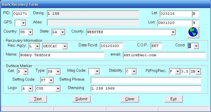
You can actually roll your mouse over each blank box (the white area) in the recovery form, and will get a pop-up telling you what goes there. Ex: The C.O.P. box is for the initials of the person responsible for recovering the mark. You will also notice from the above screenshot, just how much more information can be submitted with each recovery report now......like the relation of the disk to the surface (flush, recessed, projecting).....the code of the agency stamped on the mark......the ability to update the coordinates or county/state...etc. You'll click the TEXT button at the bottom to open up a secondary window to submit your actual recovery text/report. Make sure to do this BEFORE you hit the submit button.
As DSWorld is kinda a little intimidating, I suggest that for those of us just starting out with DSWorld, to spend some time using the help files of the program. Malcolm has some excellent information (along with screenshots)of how to utilize the program. Reading (viewing screenshots) the help file about submitting recovery reports is a good thing, especially on how to submit the recovery text. I think once you get the hang of it, everyone will really like it.
One of the things I really like about DSWorld, is it's google earth interface. I like to view the recent HH loads, and the program opens up google earth and shows you the locations. Now, I really like that when you click on each location, the program will not only let you view the NGS datasheet...but also has the geocaching page link for the mark too (if available). I guess this is for everyone to be able to access both websites/databases for information on the marks.
Now, back to your regularly scheduled program.
-
The programer, Malcholm Archer-Shee is planning on doing a webinar on how to use this tool for sometime in February. I will be sure to post the info once it's available.
I welcome Malcolm's guidance and look forward to it. I just submitted CQ1271 using the latest version of DSWorld. I used the recovery report there to update the scaled coordinates. (I usually have submitted these in a separate section of DSWorld).
I hope I understood a section of the recovery report correctly, after the stability. It has Fl/Proj/Rec along with the next boxes to place the measurements. I am assuming (I didn't find the answer in the help file yet) that these abbreviations mean Flush, Projecting,Recessed....for the mark in relation to the ground level.
-
I asked this same question of Malcolm(DSWorld) back in April. Here is his reply:
From: Bobby Tedford [mailto:wmtire@yahoo.com]
Sent: Sunday, April 17, 2011 2:17 PM
To: Malcolm Archer-Shee
Subject: RE: DSWorld problem
Malcolm, I had a question for you, not that it's a big thing, but just
wondering if there was a reason for it. When using the photo editing part of
DSWorld, the program will save the name of the pic for you using your
parameters you stated for the pic. It names it by PID, Station name, Photo
type (1, 2,3), direction facing, and date.
However when you use the program to place a standard label on the pic, it
reverses the first two parameters and the label states Station name first,
then the PID.
Like I said, I was just wondering if there was a reason for this difference.
I was guessing that it had something to do with the way the NGS indexed the
information
Bobby
--------------------------------------------------------
Bobby,
The naming and labeling requirements were established by the folks at NGS
that manage contracting. The logic, as I understand it, is that the name
was more important for the label (caption) than the PID, but the filename
had to begin with the PID for data processing purposes. It, unfortunately,
has caused some confusion among submitters. Note also that spaces and
commas are required in the caption but are not allowed in the name, again
for data processing purposes.
Malcolm
-
Just a little note, to add to PFF's post above. For anyone who doesn't utilize the program DSWorld, it will do all of the above editing correctly for you. It will rename your photo to NGS specs, and also place the proper formatted caption on the photo. You can also use the program to batch submit the photos after you have edited them to your satisfaction.
-
I guess you could count them as FTF, although a better term might be FGCTL (First Geocacher To Log). We are always proud of ourselves when we are the first geocacher to log a mark on Geocaching.com but FTF is not really an acronym that we have seen commonly used for benchmarks.
Good luck and have fun!
Just like TillaMurph's describes, we are all proud to be the first one to log a benchmark, especially one that doesn't have a recovery report since it was placed.
Although geocaching.com will keep up with the number of benchmarks you log on their site, it doesn't add these benchmark numbers to your geocache find totals. The two numbers are kept separate.
Best of luck, and feel free to ask any questions here as you delve into the fun hobby of benchmarking.
-
RL0057 STATION RECOVERY (1997)
RL0057
RL0057'RECOVERY NOTE BY MICHIGAN DEPARTMENT OF TRANSPORTATION 1997 (SHN) THE
RL0057'MARK WAS ON PROPERTY OF THE KEWEENAW BAY TRIBE OF THE OJIBWA INDIANS.
RL0057'THE BUILDING THE MARK WAS IN WAS TOTALLY DEMOLISHED 2/97 AND ALL THAT
RL0057'REMAINS IS A MASS OF RUBBLE. IT APPEARS THE MARK HAS BEEN DESTROYED
RL0057'NOTE--DUE TO ARMED HOSTILITIES (1995-96) AT THIS LOCATION, PERMISSION
RL0057'TO VISIT THE SITE IS STRONGLY RECOMMENDED
Hmmmm, guess it's time to add an AR-15 and few hundred rounds of ammo to my benchmarking bag.

-
Welcome to benchmarking. It is a little different than geocaching, but can be more rewarding.
I recommend reading the me first tutorials.....especially the difference between scaled vs adjusted coordinates. There are also several ways to download the datasheets directly from the NGS and put them in your gps units.
http://forums.Groundspeak.com/GC/index.php?showtopic=113335
I have gathered much of the information, along with software links, gleaned from these forums and fellow benchmarkers. I tried to place a lot of it here:
http://www.nelageo.net/index.php/forum/13-benchmarking-and-related-topics/6841-benchmark-101
-
While this one isn't necessarily silly, it did have a kind of WOW factor from the 1935 description. I hated the courthouse was closed, as I would have really liked to have gotten the details on it.
Here is the link,CQ0938
01/01/1935 by CGS (GOOD)
DESCRIBED BY COAST AND GEODETIC SURVEY 1935 IN JONESBORO. SET HORIZONTAL ON THE EAST END OF THE FIRST CONCRETE STEP OF THE NORTH ENTRANCE TO THE JACKSON PARISH COURTHOUSE. NOTE-- COURTHOUSE WAS DESTROYED BY AN EXPLOSION IN 1936.
I guess the note was added after the fact, from the dates provided.........or it was a Nostradamus recovery report.
EDIT: I found a newspaper story about it from 1936:
-
GR0576 STATION RECOVERY (2011)
GR0576
GR0576'RECOVERY NOTE BY GEOCACHING 2011 (MFM)
GR0576'RECOVERED AS DESCRIBED.
GR0576
GR0576 STATION RECOVERY (2011)
GR0576
GR0576'RECOVERY NOTE BY GEOCACHING 2011 (TLM)
GR0576'RECOVERED IN GOOD CONDITION.
[/code]
Apparently, another member here was following in my footsteps across the Hoover Dam when I started my trip out West. I don't recognize the initials, but I find it amusing - we reported on a handful of them across the dam - and at least we agreed on their status!

Years from now, I see another surveyor looking this up and scratching their head. "Why didn't they just go together?".
--Mike.
Hmmm Mike, it appears ya both have the same last initials. You don't have......oh just for the sake of conversation....another personality per chance.
Not that's there anything wrong with that Sybil, so you can put the knife down.
If you do have another one, he must be the procrastinator, being a week behind.
-
Why are benchmarks different colors on maps? Some are green, some are red and others white. Why? Thanks is advance.
I have a feeling you are referring to ScaredyCats Benchmark viewer. If you will scroll down to the bottom of the map page it explains the colors and symbols.
Here is the simple gist of it
Green- last recovery report was a find in good condition
White- no recovery reports
Red- last recovery report was a did not find/missing or other
Black- mark destroyed
The S or A means Scaled or Adjusted
EDIT: Here is the FAQ section that also explains it from ScaredyCats Viewer
-
Tillamurphs informed me that the nelageo site where I parked a copy of this sheet, was requiring a registration to be able to download it. I placed a copy of it in the free google docs. It should show you the sheet as well as let everyone download, copy, or print it. Just click on the file tab at the top left of the screen and choose which option you want.
Here is the link to it
https://docs.google.com/open?id=0B5IX4cufAX-rNDRkNTEzNTktOTNlOC00NTUwLWE4ZWYtZGQwNGE0NWNlYzM5
-
Is that the one that says "What is a benchmark?" and "Why am I here?" If so, I have it and could send it to you, but I don't remember where it came from.
Patty
Woo-hoo, Patty sent me the exact one I was looking for. If anyone knows the original author, I would like to credit them for it.
I placed a copy of it in our local geocaching forum, if anyone wants to download a copy.
Thanks Patty.
-
Normally I would suggest that you ask LSUFan since he has a large quantity of good educational benchmarking documents. I guess that won’t work this time.

LOL, Once I get it again, it will be saved on our local geocaching forum for all to get.
Is that the one that says "What is a benchmark?" and "Why am I here?" If so, I have it and could send it to you, but I don't remember where it came from.
Patty
Patty, I think that is it, but am not certain till I see it. Could you email it to me at hktire@aol.com or wmtire@yahoo.com?
Thanks so much.
-
At the end of a FULL day of benchmarking there is nothing like finding this just outside the rolled down window of the truck:
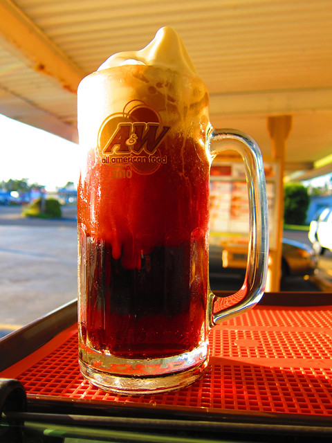
Ok, I am now officially jealous. As if the benchmark pics weren't bad enough, you just have to go ahead and rub this in our face. We don't have any A&W's around here anymore, much less a real drive-in one.
-
Several years prior (and a few computer crashes ago), I had downloaded a file that someone had made, that was a benchmarking explanation sheet. It briefly explained to landowners, what benchmarking and geodetic survey markers are, and our intent was just to take pictures and update numbers. It's real similar to the geocaching brochure that you can download from Geocacher-U.
Can anyone be so kind as to point me back to this sheet/file, where I can save it again? Thanks
-
I have nothing constructive to add to this conversation....but instead am just fussing at Jim.
Looking at all the work he is doing with the maps here, I keep seeing that Red River Parish in LA has no GEOCAC recoveries. Since I am going to be 'near' there this Friday (like 40 miles is near), I am feeling some strange, uncontrollable urge to sweep down there and color it in.
It's all Jim's fault.
-
All of my caches have been ammo boxes. Increasingly, they are disappearing. It's expensive to keep replacing them. I'm starting to wonder if people are stealing them FOR the ammo boxes. I've also noticed that fewer and fewer caches are "full size" or ammo boxes. Is this a problem everywhere?
I can't say if it is everywhere, but we have had a rash of ammo boxes being taken in our area too.
-
I caught this on another forum and I thought there would be interest here:
Maybe someone could post it to the appropriate Geocaching forum about which I am totally clueless.
Rg
If it works out the way the author of the article says it will, I guess a lot of us will be able to submit HandHeld 1 coordinates to the NGS.
-
Now the question is "What will fill the void that this recovery has left?". I had been studying the maps and the description and every time we drove past that area I would always slow down and scope out the area.
I have found the object of my quest and there is a bit of a let-down since I now have nothing left that is haunting me. Nothing that I know is there, but haven't been able to find is there to now occupy my spare time.
What a fellow to do? I know where there is another mark W 52 that hasn't been found since the 1980's, but I don't know who I need to talk to, to get permission to access the restricted area. Maybe that can be my next project.
Has anyone else gone through this emptiness after making that great recovery?
John
I understand exactly, what you are experiencing. CP2772 was my "white whale" you could say. It consumed a lot of research time, and studying of aerial maps, trying to see if a trip was warranted just to look for it.
I can say, you will eventually move on and start aiming your sights towards others, and that emptiness will fade away as you become goal-oriented again.. It's what makes the hunt so fun. As Tillamurphs states, Holograph's list of extreme benchmarks are always good.
'
If nothing else, you can hang out in the forums here with your fellow 'Benchmarkers Anonymous' support group. We have a great 12 step(or approx. 36 feet from the center of the road) program
 George Leigh with the NOAA has a fantastic article named "Bottles, Pots, and Pans: Marking the Surveys of the U.S. Coast & Geodetic Survey and NOAA"-- A history of the evolution of marks used by the Survey under different names and at different times.

The undate. Please look and respond.
in Benchmarking
Posted
Great news! Thanks for the status update, ArtMan