


LSUFan
-
Posts
656 -
Joined
-
Last visited
Posts posted by LSUFan
-
-
Mike if I understand correctly, you are wanting to search for marks that have an unknown monumentation date.
If you have used NGS-GPX to convert the datasheets to gpx files before loading into GSAK, then you can try the following:
Another filter you can try, is to do the text filter, but check the USE REG EX box. Also search 'everywhere'.
Now in the text box type (history.*unk)
Make sure to use the parenthesis and everything between them. This will check the text for the word history followed by
unk........in that order.
You can also try (unk.*monumented)
-
GSAK can do all sorts of filters ------
One more attempt to resolve what I consider to be a glitch in GSAK when I am trying to Hi-grade for older marks to pin on Google Earth.
Have you been able to set a filter that will sort for UNK in the history?
SX0682 HISTORY - UNK MONUMENTED USGS
Mike, not sure if this helps or is what you need, but you can use GSAK to search thru all text (which would include history)
Click the search tab at top of GSAK, now click filter-----make sure the general tab at top is active---- in the set filters box around the third line down, there is a full text search box. You could just type UNK into this box..... and filter all the marks with UNK in them.
The problem I see with this approach, would be all the marks that also have UNKnown stability in their description/text. Might not filter the marks down enough to be of use.
Bobby
-
YellowstoneHunter, I got ahold of my friends copy of your book. Man, you have gotten me wanting to go to Yellowstone now.

I really am enjoying it, and liked the history you have provided, especially about Old Faithful and the fact you used to be able to drive up in front of it. It's very helpful, in telling everyone where to park in looking for particular marks.
Thanks for going to the effort and putting this book together. I highly recommend it for anyone who may planning a trip there.
Now I just have to get the time and money to go benchmarking in Yellowstone.
-
NGS reported to us about 5 years ago that they really weren't interested in recovery reports for intersection stations (spires, poles, etc).
I have to ask, why?
Here is one of the forums and the following excerpt from it, with the response by Deb why the NGS no longer wanted any reports about Intersection Stations.
http://forums.Groundspeak.com/GC/index.php?showtopic=264093
In late August we had a discussion (link) about reporting destroyed intersection stations (e.g. water towers, church steeples, etc) to NGS. It has been stated by some here that while NGS (Deb Brown) no longer wishes to receive positive recovery reports on intersection stations, destroyed interesection stations should continue to be reported to NGS so that they can be removed "from the active database to reduce clutter."
Shortly after that discussion I emailed Deb Brown the following:
Deb:In the past you've indicated that you would rather NOT receive GEOCAC
recovery reports on intersection stations. Does that also apply to destroyed
reports on intersection stations?
The reason I ask is that there is currently an assumption among GEOCAC
participants that while you DON'T want recovery reports on intersection
stations, you DO want destroyed reports when there is evidence that the
intersection station has been destroyed.
Yesterday I received the following response from Deb:
Sorry for the delay in responding.Typically I'd rather not get info of any sort on intersection stations
or landmark stations, however, if I get them I process them. The advent
of GPS has eliminated their use.
deb
So I would humbly suggest that we respect Deb's wishes and refrain from submitting info of any sort to NGS concerning intersection stations.
Tim
-
I'm only a standard member, and pretty new but I like the idea of hunting for really hard cache! Is there a way to search for one? I can't seem to find it as a search option.
Thanks in advance
Just do a standard zipcode search (from the browse box on the opening page of geocaching.com) for the caches in your area.
When the list of caches loads up, you can click on the D or T (difficulty/terrain) header at the top of the column. Clicking on these will resort the list of caches by most difficult or least difficult......as well as hardest terrain to easiest terrain.
You can also click on the column headers to resort your list by...favorite points, placed date, and last found date.
-
SK0180 STEAMBOAT LAKE CAP was destroyed in 1933 when STEAMBOAT LAKE RESET (SK0183) was set. It was a pipe cap marked P.B.M. 1898. kayakbird, the photos you have are of the 1933 reset. Different mark.
I have ran across several US Corp of Engineers cap/bolt pairs that have been reset like the one that Mike has pictured. It appears that the cap (and corresponding subsurface bolt) have not been physically replaced per se........but just stamped over using the same cap in place. These marks haven't been moved, just basically releveled and stamped with the date that the new measurements were taken, and thus gotten a new PID.
Mikes pic is of P.B.M. 1898, that was then overstamped with the 1933 Reset when the USC&GS used it in that year.
I am always envious of the old historical marks he finds and wish I could accompany him on one of these trips..

-
he's awesome about fixing or adding improvements to the program.
I totally concur. I have corresponded with Malcolm on several things about DSWorld, and he has always helped me. If you know of something you would like to see in DSWorld, I would follow Dave's advice and contact Malcolm. He is constantly improving the functionality of the program.
-
Specific questions:
(1) Is anyone else experiencing connection problems? I've noticed it sometimes takes a few tries to connect to NGS directly (not using DSworld). I have three computers, all running Windows. I keep them updatedm and one is only one year old, running Windows 7. The new computer uses Norton Security, and the other two rely on the Windows security package.
(2) Is there a way to verify that an upload was successful--other than waiting a couple of months and then checking each station individually in the data base?
-Paul-
Paul, which version of DSWorld are you using. The later versions have a log feature (in the view menu), that the program will keep logs of all your submittals...whether they are recovery reports, HH2 corrections, photos, etc.
DSWorld only keeps logs from the computer you submitted the information from. EX: If you have DSWorld installed on multiple computers, say computer A and computer B....................then you can only see the submittal logs for computer A that you used DSWorld to submit from computer A.
The NGS also state that any version of DSWorld below 2.05 won't function correct. Here is a copy of that from their site:
DSWORLD (Version 3.00)
DSWorld plots NGS network points by state, county and type (vertical or horizontal) in Google Earth. Google Earth must be installed prior to running DSWorld.
NOTE: After installing DSWorld, please run 'Tools>Update Program' to insure you have the latest intermediate update.
NOTE: Because of changes to NGS web offerings, older versions of DSWorld no longer function. Please upgrade to the latest release (2.05 or better).
-
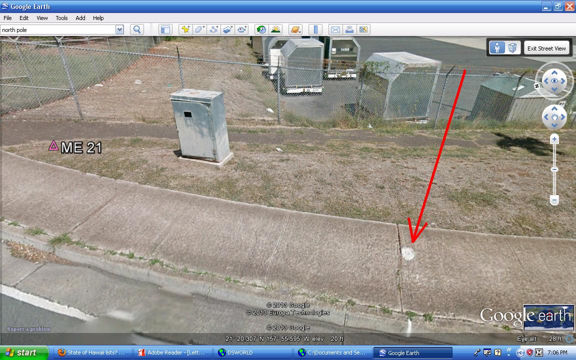
It's hard to really read the designation but it appears to have ME-21 stamped on it. Using DSWorld, I was able to find benchmark with PID DN6349 that has designation ME-21. DN6349 appears to be at the Honolulu Airport.
Since this mark was monumented in the year 2011, it will not be listed on gc.com because they only have marks from the year 2000 and earlier. It is however listed on the NGS site, which I provided a direct link to (if this is the correct mark)
Here is a link to the bluebooked NGS datasheet and a copy of it posted. Does the description on the bottom of the datasheet match where you found the disk? It would help tremendously if you could tell us the coordinates where you found the disk.
http://www.ngs.noaa.gov/cgi-bin/ds_mark.prl?PidBox=DN6349
DN6349_MARKER: DD = SURVEY DISK
DN6349_SETTING: 0 = UNSPECIFIED SETTING
DN6349_SP_SET: SET IN SIDEWALK
DN6349_STAMPING: ME 21
DN6349_MARK LOGO: HIDT
DN6349_MAGNETIC: N = NO MAGNETIC MATERIAL
DN6349_STABILITY: D = MARK OF QUESTIONABLE OR UNKNOWN STABILITY
DN6349_SATELLITE: THE SITE LOCATION WAS REPORTED AS SUITABLE FOR
DN6349+SATELLITE: SATELLITE OBSERVATIONS - April 05, 2011
DN6349
DN6349 HISTORY - Date Condition Report By
DN6349 HISTORY - 20110405 MONUMENTED HIDT
DN6349
DN6349 STATION DESCRIPTION
DN6349
DN6349'DESCRIBED BY HAWAII DEPARTMENT OF TRANSPORTATION 2011 (CG)
DN6349'STATION IS LOCATED IN HONOLULU, HAWAII BY THE HONOLULU INTERNATIONAL
DN6349'AIRPORT.
DN6349'
DN6349'TO REACH THE STATION FROM THE INTERSECTION OF NIMITZ HIGHWAY AND
DN6349'KAMEHAMEHA HIGHWAY HEAD EAST 1.6 KM (1.0 MI) PAST VALKENBURGH STREET
DN6349'TO THE INTERSECTION OF ELLIOT STREET AND NIMITZ HIGHWAY.
DN6349'
DN6349'THE STATION IS IN THE CENTER OF THE CONCRETE SIDEWALK 13.1 FT (4.0 M)
DN6349'SOUTHWEST FROM THE SOUTHWEST CORNER OF 600MM BY 1000MM CONCRETE PAD
DN6349'FOR UTILITY CABINET, 38.6 FT (11.8 M) SOUTH FROM THE CORNER OF 8. FT
DN6349'(2.4 M) HIGH CHAIN LINK FENCE, 79.2 FT (24.1 M) WEST FROM THE
DN6349'SOUTHWEST CORNER OF CONCRETE FREEWAY OVERPASS SUPPORT COLUMN, AND 31.9
DN6349'FT (9.7 M) NORTH FROM THE END OF GUARDRAIL.
DN6349'
DN6349'NOTE YOU WILL NEED TO CONTACT THE AIRPORT MANAGER FOR AN ESCORT TO
DN6349'STATION.
Here is a screenshot of where Google Earth pinned this benchmark. Since the mark has posted adjusted coordinates, it should be fairly accurate as to the location.
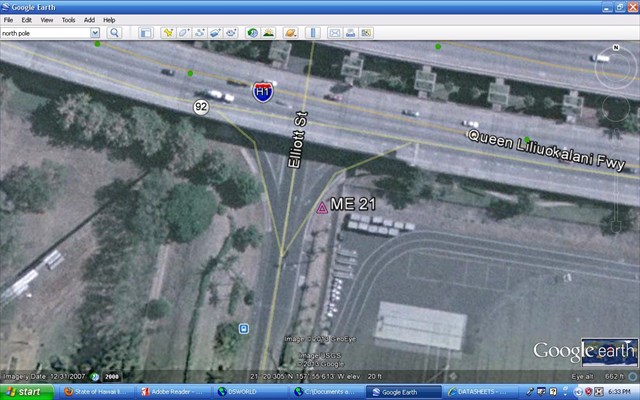
When I go down to google streetview, I think I am able to see the disk in the sidewalk. The concrete contour and expansion gap seem to match the one in your pic.
Even if this isn't the correct mark, I've had fun researching it and using the computer to look for it virtually.
-
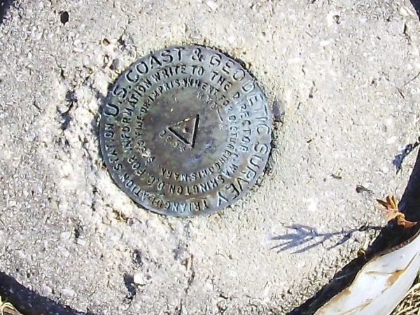
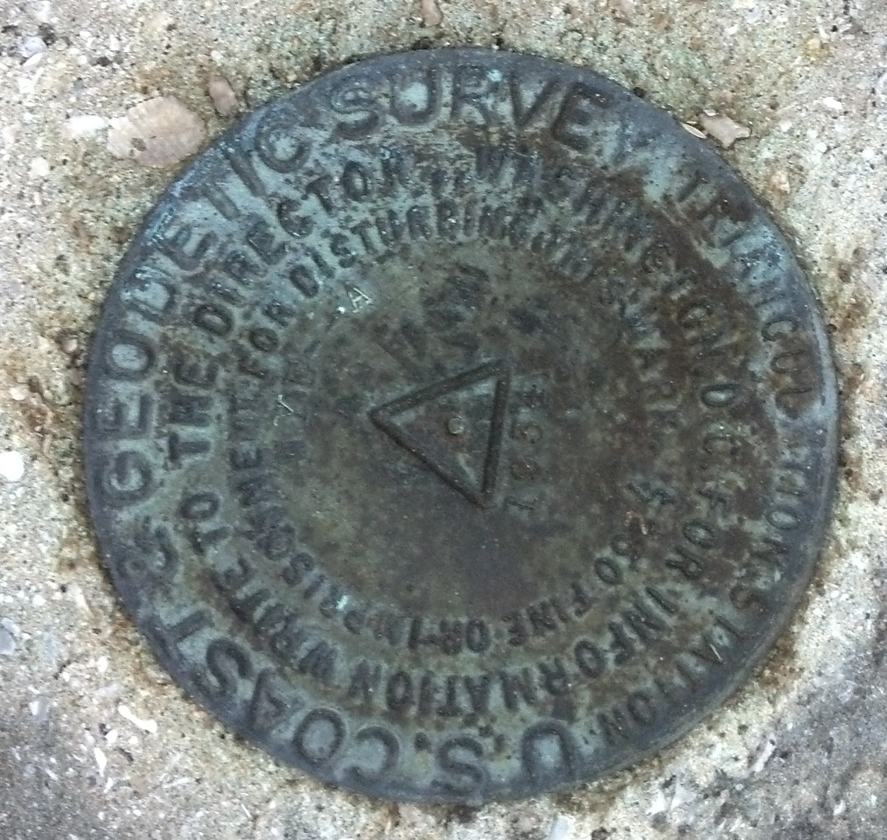
This does seem to be an interesting situation. To help illustrate, I have overlaid an image from ScaredyCat's benchmark viewer with information from the box score for WYE-Reset (AC0533).
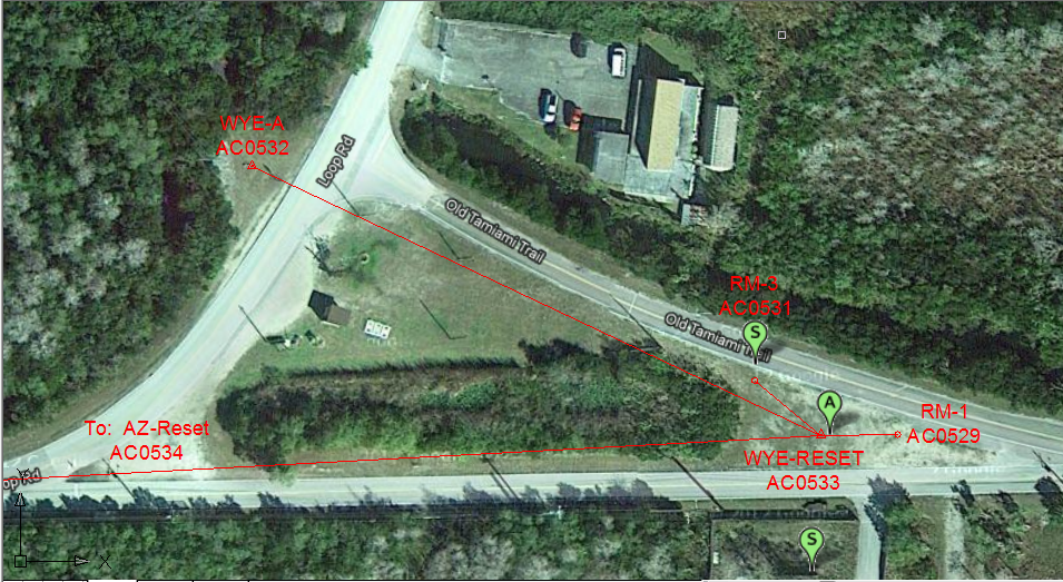
You can actually see the marks for WYE-A and RM-3 in the photo. (You can also see them, along with their witness posts, on Google street view.)According to the datasheet description, WYE-Reset is recessed below ground level. WYE-A should not have been listed as destroyed, since its datasheet describes the existence of an underground mark. The change in date, from 1934 to 1954 in the GC photos remains a mystery!
After re-examining the photos of WYE-A, I believe they are the same disk. The difference in lighting is making the 3 look like a 5. Mystery solved?
Well, we downloaded Joshism's photo and turned it and then used photoshop to enhance it a little. What a little cornstarch would have done in real life for us, a little enhancement does now.......
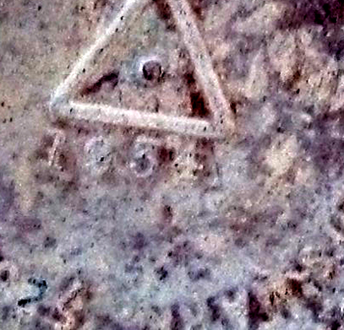
Notice the "5" now looks like the old fashioned "3" that was used in that day and age. So, that mystery is now solved......
Thanks Holtie.
Shirley~
That is what I like about these forums and the benchmarks sleuths we have here. It's going to get figured out. Great job, everyone.
-
but will really only want to hunt for marks never found or seen in 40 + years etc.
frex3wv, I am like that too, and really like the ones that have no recovery reports.....or none in many years.
I scour ScaredyCats maps for those white icons.
-
Odd that it is possible to search for destroyed marks, but the direct link to the datasheet doesn't work.
Not really odd at all. You can think of the NGS databases as filing cabinets. You have one database/filing cabinet full of active (published) marks. You would go to this one to see the datasheets for benchmarks that are supposed to be active in the field.
Now, once a mark gets reported as destroyed (sometimes incorrectly), it's datasheet is removed from the active filing cabinet...and placed in the inactive (unpublished)filing cabinet.
When you say "direct" link, you are only referring to the published marks (or active filing cabinet).
You can do a search for datasheets on the NGS site, and tell their computers that you want to search both the published and unpublished files for marks.
You also need to always remember that everything you see on gc.com from the NGS, was what was in the NGS published database/filing cabinet from the year 2000. Anything that has changed at the NGS (ie marks getting moved to the unpublished files, new marks added to the published files, etc) since the year 2000 will not be reflected on information you are reading on gc.com.
-
Photos added to my BM log now. The metal band is still there around the concrete, but there were no other benchmarks close by.
Odd that it is possible to search for destroyed marks, but the direct link to the datasheet doesn't work.
Judging by your picture, you did Not find AC0532. WYE A is supposed to be stamped 1934 and the one in your picture is stamped 1954.
Not sure which one you found but WYE A was monumented in 1934. It is possible that you found AC0533.
John
Houston, we have a problem...........or really a mystery (our favorite kind in the forums).
I agree with John, in the assumption you didn't find AC0532. It should be stamped 1934, which the geocaching logs before yours do show a pic of WYE-A 1934............where your pic shows WYE-A 1954.
However, AC0533 WYE Reset 1934/1971 is supposed to be 131.691 meters away from AC0532 and the stamping doesn't match it either, according to the 1971 recovery reports from the NGS.
http://www.geocaching.com/mark/datasheet.aspx?PID=AC0533
It also appears we have an incorrect geocache log for AC0533 from Paradise in 2004. The pic that was posted, although unclear, shows an arrow on it, which means it was a reference mark or azimuth mark disk.......and not the triangulation station itself.
I'm wondering how many WYE tri-stations are there in this area?
I will do some further studying, and am curious to see what others come up with too.
-
Kind of a funny sidenote to all this discussion.
A benchmarking/geocaching friend of mine and I were eating lunch yesterday, where he was talking about him and his wife taking a vacation later on this year. He then stated he was thinking about going back to Yellowstone where they had went several years ago. He also added that when he was there originally, he had climbed up a hill and accidently found a benchmark there, but since this was before he got into the hobby, he didn't take pics or coordinates. He said he has been thinking about that particular benchmark for awhile, and was going to go back to it if/when they make it back to Yellowstone...as well as looking for other benchmarks there.
I started laughing, and stated how this forum thread was going on, and about the book mentioned in the OP, which I was thinking about buying.
I hadn't got back to the shop long after lunch, when my friend called and said he bought the book off Amazon...and they were most likely going to Yellowstone.
Now, I get to read his copy and don't have to spend my money.
A big THANKS to everyone.
-
OK everyone. Here is the classic example of the "Why" to NOT report "Destroyed" on any benchmark or bench mark unless you have the disk in hand or undeniable proof that it is indeed gone (as in a building imploded or a mountain top blown away by a volcanic blast). And the reason to go look to see if the mark is really gone if you see a mark declared as destroyed on GC.
Please don't tell me I return to be accused of maleficence? I will not tolerate being made of as an example for the follies of others.
OK everyone. Here is the classic example of the "Why" to NOT report "Destroyed" on any benchmark or bench mark unless you have the disk in hand or undeniable proof that it is indeed gone (as in a building imploded or a mountain top blown away by a volcanic blast). And the reason to go look to see if the mark is really gone if you see a mark declared as destroyed on GC.
!!Do NOT submit any "Destroyed" reports to the NGS unless you do have that disk in hand or undeniable proof that it is indeed gone, because it WILL disappear from the their easily seen data base!!
CLASSIC EXAMPLE!
Early on in our hunting - 2003 - we thought a mark PID GP0270, H 405 had been destroyed due to bulldozing in the area that we thought the mark should be.
Then one day, about a month later as we were driving past the area, I spotted a witness post - on the other side of the highway than where we had looked previously. I pointed to it and yelled "Witness post"! John tromped on the brakes and turned the truck around and we went onto a side road to look at the witness post. He got out his compass and finally found the mark buried in the sand. It was what we have now found out - things today can appear very differently than when the data sheet was written. It doesn't necessarily make the data sheet wrong, it is just how things have changed so much over the years.
That is extreme fun of researching these old marks.
So, have fun, just make notes instead of calling something destroyed, to save face.

Shirley~
~~~~~~~~~~~~~~~~~~~~~~~
I don't see where you were supposedly made an example for the follies of others. I did see where you didn't quote enough of 2oldfarts's initial post to see where they were talking about the "classic example" being something they had done, which was followed by the title of "classic example" and their tale. I emboldened it so it will stand out above.
-
Ok I'm still learning and now it shows. What is a box score? What is its significance? And how do I recognize that a mark has one of these on datasheet?
CityHuntersBJB, you can also read NGS Surveyors excellent pinned topic on triangulation stations (which have the box scores) at:
http://forums.Groundspeak.com/GC/index.php?showtopic=185361
Although EdrickV has answered your question with a more detailed explanation, Gc.com also explains it in their benchmarks Q&A section:
http://www.geocaching.com/mark/#boxscore
When searching for triangulation stations (my personal favorite benchmarks), you need this box score information to help find the reference marks. A lot of times you may find a reference mark first, then use a reverse compass azimuth from the box score and be able to measure off the direction and distance to the main triangulation station disk.
Box scores are why it's a good idea to purchase a double-sided tape measure that has feet(SAE) on one side and meters(metric) on the other side. You'll find most box scores have the distance in meters, but the other reference objects listed in benchmark descriptions have the distance in feet (ie from center of road, distance to trees, buildings, etc).
Here is one tape measure I have several of:
http://www.harborfreight.com/1-2-half-inch-x-330-ft-open-reel-measuring-tape-36819.html
-
We benchmarkers can really appreciate the jobs that our great friends at the NGS/NOAA, USGS, and other agencies do in order to help map out our world.
However, sometimes mistakes can happen, with some very bad consequences. If you haven't already heard, our US Navy had a minesweeper get stuck on a reef in the Philipines supposedly due to an error in their digital maps. It looks like the ship is going to have to be demolished to get it off the reef.
This is another example of why having correct geospatial information is so important.
http://www.kmbz.com/US-Navy-Minesweeper-Stuck-on-Philippines-Reef-to-B/15394675
-
As stated, what is on-site looks to be more than 14 feet (but this could be an error or typo) from the centerline. It also appears they may be new concrete, as the colors don't seem to match, at the near end of the canal.
You could just go across the road and locate TU0202, which was found as late as 1997. Once located, You could then stretch a tape to measure the 95.3 feet that separates the two benchmarks...and see where this puts you on the canal wall.
Even if you cannot locate TU0202, you should be able to measure out where it should have been from it's description...then still run a tape to measure off the 95.3 feet to be accurate.
Just doing quick math, TU0202 is 81.6 feet southwest of centerline of Pulehu Road according to it's datasheet. Subtracting this measurement from the total distance of 95.3 feet between the two benchmarks, gives a difference of 13.7 feet (real close to 14) for northeast of same centerline of road where TU0203 should be located.
From reading the 1993 NOS recovery report on TU0202, where they checked the elevations of TU0202 and TU0203.....it makes me wonder if they weren't the ones who actually inscribed what you are seeing on the concrete wall.
Here is the TU0202 recovery I am referring to:
08/13/1993 by NOS (GOOD)
RECOVERY NOTE BY NATIONAL OCEAN SERVICE 1993 (JGF) THE STATION IS 4 MI (6.4 KM) SE OF THE TOWN OF PUUNENE ON THE ISLAND OF MAUI, HAWAII. TO REACH FROM THE POST OFFICE IN THE TOWN OF PUUNENE, PROCEED E ON HANSEN RD FOR 1 MI (1.6 KM) TO PULEHU RD ON RIGHT. TURN RIGHT AND PROCEED 3.6 MI (5.8 KM) TO GRADED CROSSROAD AT LOWRIE DITCH, ON RIGHT SIDE OF HIGHWAY IN W ANGLE OF CROSSROAD ON NW BANK OF CANAL. THE STATION IS 81.6 FT (24.9 M) SW OF CENTERLINE OF HIGHWAY, 68.8 FT (21.0 M) SW OF CENTER OF SW RAIL OF HIGHWAY BRIDGE, 5 FT (1.5 M) NW OF EDGE OF CONCRETE CANAL BANK, 11 FT (3.4 M) SW OF CENTER OF CANAL ROAD, 95.3 FT (29.0 M) SW OF BENCH MARK 460(USGS). THE MONUMENT APPEARS TO LEAN SLIGHTLY AWAY FROM THE CANAL, BUT A CHECK IN DIFFERENCE OF ELEVATION BETWEEN BM 460(USGS) INDICATES THAT THE MARK IS AT ITS ORIGIONAL ELEVATION.
P.S. Looking at Google Earth, it appears you would have to cross a NO TRESPASSING line to look for TU0202. Just letting you know.
-
I've been trying to access this particular datasheet to see if NGS has updated it with my recovery, but it seems to just stop and give out garbled lines. Is anyone able to get the thing to load fully?
http://www.ngs.noaa.gov/cgi-bin/ds_mark.prl?PidBox=TU0203
The marker that I reported: http://www.Waymarking.com/waymarks/WMFRY5_US_Geological_Survey_460_Puunene_Maui_Hawaii_DESTROYED
The mark has been reported destroyed (by you and this was accepted by the NGS) so the datasheet shows as much, which is why you are probably getting a datasheet link that doesn't show anything on it. You can scroll to the bottom of what you are getting and see that the mark has two X's, for horizontal and vertical, which means it was destroyed.....as you can read in the non-published reasons/codes above.
When a mark is reported destroyed, the main datasheet, for a lack of better terms, goes into a different database (non-published)......... vs the (published) datasheet database that you are used to seeing.
It's basically just a filing system that keeps destroyed marks out of the file that shows active marks. When you search the published/active marks database now for TU0203, what you are getting in essence is a placeholder comment that tells you that there used to be a datasheet here, but it was moved (or removed) after being reported destroyed.
You can still access some destroyed marks datasheet by going to the NGS datasheets site:
http://www.ngs.noaa.gov/cgi-bin/ds_pid.prl
1.Enter your PID in the box, then make sure to check the "include destroyed marks" option.
2. Click the submit button
3. Highlight the PID and info line in the box
4. Select get datasheets
You should now get the datasheet which you are trying to find, which shows the following:
TU0203 STATION RECOVERY (2012)
TU0203
TU0203'RECOVERY NOTE BY GEOCACHING 2012 (KAK)
TU0203''USBM' PAINT MARKING NOT FOUND. 'BM' ETCHED INTO CEMENT FOUND ON
TU0203'ABUTMENT. HOLE IN CEMENT NEXT TO 'BM' AND IS ASSUMED TO BE FORMER
TU0203'LOCATION OF THE DISK.
TU0203
TU0203 STATION RECOVERY (2012)
TU0203
TU0203'RECOVERY NOTE BY GEOCACHING 2012
TU0203'DISK HAS BEEN REMOVED.
P.S. There has been some debate several times in these forums whether or not geocachers/amateurs should be reporting marks as destroyed (vs did not find) to the NGS. One of the points being, that once a mark has been accepted as destroyed by the NGS, then it takes the datasheet out of the published database. What if the amateur was wrong and the mark is still there? Now the datasheet is unpublished for future use.
Personally, I do report marks that are 'definitely' destroyed as such.....but make sure without a doubt. You need to be very certain when submtting destroyed reports to the NGS. If there is any doubt, then report it as "did not find".
A good example is a road that has been paved over, that may have buried the mark underneath the asphalt/concrete. Technically, the mark is not destroyed, just very inaccessable.....and should be reported as a 'did not find'. You just need to state the mark may have been covered over in your report.
If there is some uncertainty (like you don't have the disk in hand or know for a fact that a bridge, building, or other setting has been demolished), you can always submit a "did not find" report, but say it's presumed destroyed. This way the datasheet stays in the published database, but future users will know that it probably isn't there by reading your recovery report, and won't expend the energies to find it.
-
It's back going.
-
Speaking of Reference Marks, this one has me confuzzled.
KV4728
HARBOR LINE 1913 RM 26
Harbor Line 1913 is listed as destroyed (I think). But, a station with 26 RMs??? Most of which have never been found again. The one I went searching for seemed to have been deliberately removed.
Almost as strange as the series along the Hackensack Rver, by boat, set in clay tile pipes. Think only one of them was ever found again.
But what is "Harbor Line"?
Harry, I don't believe these are Reference Marks for a triangulation station (or in the sense we are used to)
Using DSWorld, I was able to get the marks that have that name and they appear to surround Newark Bay. I think these were placed to help in building Port Newark itself. Wikipedia states that the construction of Port Newark was begun in 1910 and accelerated in WW1...which would coincide with the 1913 date.
http://en.wikipedia.org/wiki/Newark_Bay
An online real estate dictionary defines Harbor Line:
An arbitrary line set by authorities on navigable rivers, beyond which wharves and other structures may not be built. Also designated as line of navigation.
Here is a pic I made from Google earth with the Harbor Line 1913 RM's plotted...so you can see they go around the perimeter of Newark Bay.
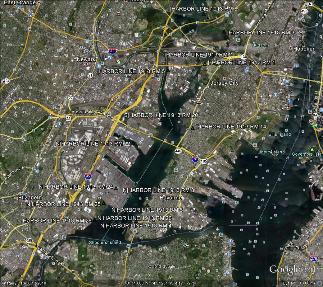
You got you a good question here. Maybe the wiser ones than I can answer it correctly. I'm just guessing.
-
I've been having lots of difficulty loading the Mississippi Geocacher's association website, www.msga.net. I've tried it on several different devices with the same result. The main page takes forever to load, and trying to load the forums causes a 500 error.
Anyone else having problems?
edit: apparently, you can't abbreviate association without getting bleeped.

PK, I think you must have broken it.
-
it appears to me to be a marker placed out by a registered land surveyor/RLS (with a license number of 5075). Doing a check on the Florida surveyor website, that license number belongs to Gary Ward Wallace/GWW.
You can contact him at :
GARY WARD WALLACE
20368 SOMMERSET COURT, PURCELLVILLE, VA 20132
Phone 703-674-1300
https://csapp.800helpfla.com/cspublicapp/businesssearch/businesssearch.aspx
He might can tell you if he was the one who placed the marker, and what purpose it was for.
-
Does anybody have any incite into this?
Benchmarks were never any form of geocache. They were not placed, maintained, thought up by, nor owned by geocachers (or the corresponding webpage for each).
At least with virtuals, and locationless caches, the idea of was begun by geocachers.
Benchmarking was always just a form of addendum activity, that could be done while geocaching. Thus, as such, benchmarks finds were never included in the smileys.
Personally, I enjoy benchmarking more than geocaching.


What Is Going On?
in Benchmarking
Posted · Edited by LSUFan
I guess the first question is what exactly did you use to plot the reference marks coordinates by their distance and bearings from the main station?
The NGS does have software to help with calculations like this.
http://www.ngs.noaa.gov/PC_PROD/Inv_Fwd/