


LSUFan
-
Posts
656 -
Joined
-
Last visited
Posts posted by LSUFan
-
-
I've seen a couple dozen of those light weight ones. This somewhat smaller rock mount could have been drug
down the borrow for a half mile and then barged the rest of the way to my house last week;
and I mean right to my front door.
kayakbird
Hmmmm, at least your grass got watered so it's all green.

If you want to talk about irony, down here in Louisiana where we are having all the flooding from the overflowing MS River and such...........we just went under a statewide outdoor burn ban yesterday (due to dry conditions)

-
Looks like about 70# of concrete attached to it.
Looks like about 70# of concrete attached to it.
How much would a 10 X 8 X 3 ft sandstone weigh?
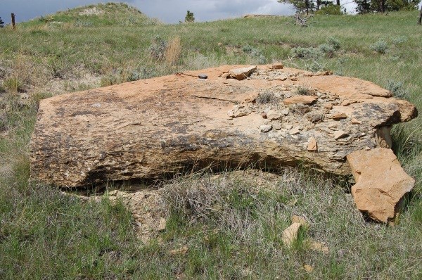
I'm pretty sure that this one has shoved dirt from several yards away.
kayakbird
Even if you bought the disk fairly cheap, I bet shipping and handling costs would be a killer
-
The following has been submitted on EBay's feedback page:
http://myworld.ebay.com/sirmarkw/?_trksid=p4340.l2559
This item was misrepresented in its advertising. It is nothing more than a Reference Mark disk intended to point to a main survey disk no more than 0.6 mile distant. It did NOT point the way to Washington DC. Moreover, the Seller copied all of his information, word-for-word, from Wikipedia's "Espionage" article.
Please do not allow the sale of Government survey markers. It encourages people to steal these objects--which were placed at great expense to Taxpayers.
PFF, I didn't see that comment listed in his feedback. It may have been removed.
I know that NGS Surveyor has stated several times that he contacts the seller/Ebay whenever he becomes aware of one of their disks being offered for sale.
Maybe the powers at the NGS, USGS, Corps of Engineers, etc need to send Ebay an official letter stating the importance of these markers and that they are govt property......and see if Ebay will ban these kind of items of being offered for sale.
I sure would hate to have to start a future email off with:
Hey Deb Brown, when you have time, can you check out Ebay listing so and so, and mark it as destroyed.
-
There are some additional photos of the event on Berntsen's Facebook page. Not surprisingly, they made the marker.
Patty
Berntsen also is selling a replica of the COP marker if anyone is interested.
-
Last time one of these showed up on Ebay, a lot of emails were sent saying it was a stolen item and the listing was pulled.
It appears that the seller isn't going to voluntarily pull it, and Ebay isn't going to force the issue on him. He has over 7000 sales with them, which is a good chunk of change for Ebay. Don't want to bite the hand that feeds you.....even if it does have some dirt under the fingernails.
EDIT: Wow, it sold for a good amount. I guess someone believed the story. It's like P.T. Barnum always said.........
Hmmmm, maybe I should buy some blank disks from Berntsen, to sell on Ebay. My creative writing story will be that these were the disks that Flight 19 was following the arrows on in 1945, when they disappeared near the Bermuda triangle. After an investigation, it was discovered that a dyslexic subcontractor had mounted a disk with the arrow pointing in the wrong direction, which resulted in the flight being lost. All the disks were removed after this and they were redacted (which is why they are blank), as part of a government coverup.
-
http://cgi.ebay.com/360367275903
Jerry Penry noticed this one and posted on another forum. You couldn't imagine the story the seller concocted to advertise it.
You're correct. I couldn't have imagined that one.........but this person sure does have an imagination. WOW!
I went ahead and sent an eamil to the seller, with an explanation about triangulation stations, reference marks, etc......just in case he didn't know.
Now for the fun, I wish we knew where this reference mark actually belonged. It's hard to know, since there is only a date and reference mark disk number imprinted on it (no station name).
-
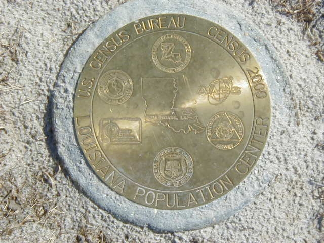
OK, since ya have revived this topic, I got to looking at the one in Louisiana again. Another benchmarking buddy of mine, keeps talking that we need to run down there and post a recovery on it one weekend.
However, when I looked at the datasheet for it, there are photographs included. These may be from when it was monumented, but not sure. The concrete does still look fairly new in the photos.
http://www.ngs.noaa.gov/cgi-bin/ds_mark.prl?PidBox=DE5745
There are two pics, that don't seem to go with this disk at all though, and are showing up on the datasheet for it. One appears to be for a triangulation station reset named Garner (which I can't find in my active database of Louisiana benchmarks)....and the other seems to be some kind of cooperative disk between the power squadron and NOS.
Anyone have any ideas on why these would be showing up on the COP datasheet for Louisiana?

http://www.ngs.noaa.gov/cgi-bin/get_image.prl?PROCESSING=get_figure&IID=2630
http://www.ngs.noaa.gov/cgi-bin/get_image.prl?PROCESSING=get_figure&IID=2629
Oh Yeah, and here is a pic from the datasheet of ours. Photographer Unknown (right now)
-
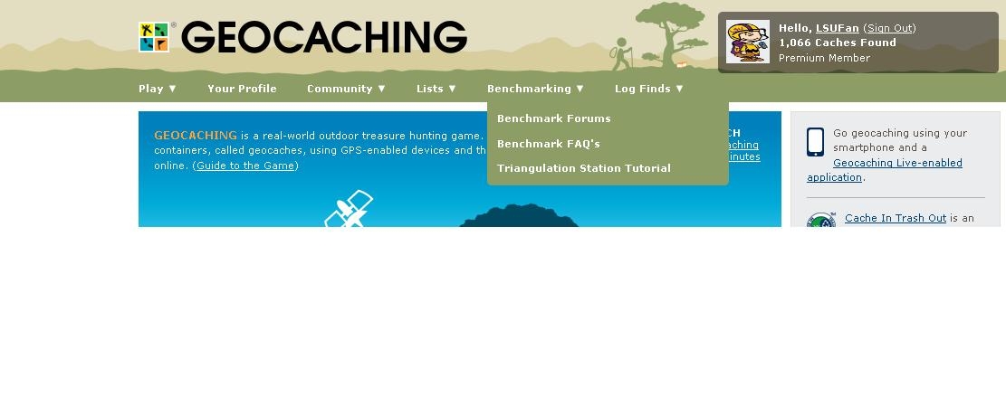
I remember how we were unsuccessful in getting gc.com to move the benchmark links back to the left-hand column of their main page (which is a mute point anyway, since they have changed the main page entirely now).
Since they have a new look, some things take a few more clicks to get too. Well, if you are a firefox browser user, and utilize monkey scripts.....you can change how gc.com displays in your browser, by making user definable tabs at the top. You can add more drop down items in each category and change the names of the categories/drop down links.
Delta68 (thanks Mark for providing this) over in the U.K. has made this monkeyscript, and included directions in the script itself, on how/what to change....so everyone can do their own to their preferences. It's not hard, but does take a little knowledge of the greasemonkey scripting stuff. I figured with all the computer gurus we have here, they may like this and can write all kind of good stuff.
Here is the link to Delta68's topic:
http://forums.Groundspeak.com/GC/index.php?showtopic=274005&pid=4711358&st=0entry4711358
I included a screenshot below of how gc.com displays in my firefox browser, after I modified Delta68's script to change the "resources" tab to "benchmarking" and added the three main benchmarking things I use on gc.com to this dropdown list. I plan to add even more later. You can also see how 'videos' has been changed to lists, and 'shop' to log finds.
-
I've written this Grease Monkey script to modify the new geocaching.com menu.
I wrote it a few days ago and a few bods on Facebook have tried it successfully but I've now simplified it (actually it's a lot more complicated but it looks simpler
 ) so users can easily tweak it to their own requirements using just two functions:
changeLink() and addSubMenuItem()
(Full instructions in the file)
As it stands there are a few new links and a few modified existing ones which hopefully most people will find useful.
http://www6.brinkster.com/coolsite/greasemonkey/customise_menu.user.js
Thanks
Mark
Mark, thanks so much for this, and for sharing the instructions on how to modify it. I will definitely be using this.
-
Has anyone built their own metal detector for finding buried benchmarks? If so, how did you do it?
BasicPoke
I had saw this on youtube before, and was thinking about making a McGyver kind of multi-geocache placement based off of it. The searcher would find the objects to put together (as in the video) then use it to find a container with coordinates in it to the cache location. I never tested it in real-world applications to see if it really works....
-
Click the "i" symbol near the upper middle for some fascinating background (which you likely already know).
To turn the symbol labels on/off click Menu ==> Labels On/Off.
That is extremely interesting, and I didn't know that. Thanks for sharing. Everyone is on high alert near the River. They are saying we are going to get higher water than even in the 1920's record floods. Our governor has been flying around a lot. It's going to be nailbiter, hoping the levees hold.
I do know some history of the MS River closer to home, being an amateur local Civil War buff. During the Union Army siege of Vicksburg, there were several attempts to dig canals off of the MS River, and thus allow the navy ships to bypass the guns of Vicksburg, and effectively cut off it strategic importance. These attempts failed...........but in the 1870's, the MS River altered it's course naturally....thus bypassing Vicksburg after all.

You can go to your map link, and follow it up north to Vicksburg and see where the MS River now leaves the main part of Vicksburg out of it's path.
-
Joseph, I just played around a little with your mapping program this evening. Your help file about using google sites for placing files free on the internet, was excellent and extremely easy to walk thru. I didn't have any idea that google had that.
I used GSAK to help me sort thru some benchmarks I have found, then exported this file in a gpx file. I then uploaded this gpx file to google sites (per your instructions), and here are my results. I will really learn more about your maps when I have more time, but I see a lot of uses for it. Thanks for sharing with us
-
Windows 7 is different from earlier versions. I am unable to locate the "File associations". I would love to run this program but cannot get the configurations.
Shorbird, I sent you an email with the name/email of the designer of DSWorld. He has helped me with some questions I had, and maybe knows what to do for the kind of problems you are encountering.
-
If anyone missed the first episode of the series, it's replaying again tonite at 7 Central time
or you can see it online here:
-
I attempted to do a .gpx download from the NGS site as listed in the "Me first" section and my state(WV) has none listed and gives me an error. Has anyone else ran into this and am I doing something wrong???
Mike
Mike, whenever you download datasheets, they are going to be in the .dat file format. You will need to use a convertor program that changes them to a .gpx format that your gps unit and programs like GSAK can read.
There are a few fantastic pieces of software that will do these conversions for you.
(Listed in alphabetical order)There is one called BMGPX, another named NGS-GPX, and another called NGSREAD
-
Shorbird, I have found out that when using the DSWorld help file, it is easier for me if I do the following.
Once I click on the "DSWorld help' tab at the top of the program, I make sure on the next window that appears, that I select the 'contents' tab and not the 'index' tab.
Then after I had made sure the contents tab is active, I click the '+' in front of each file name to expand the help file topics.
I now can see all the help topic file titles, and just click on each one that I need....especially the"problems and suggestions" and 'google earth settings' the first time I used the program. I had to change some settings on my computer and in google earth.
I have also seen that when I submit photos and handheld 2 coordinates using DSWorld (and other functions), that it has to connect with the NGS servers each time, You can read this happening at the bottom of the window and you have to allow the program time to do it. You will always get a thank you popup window, once it's done.......so make sure you get this before going to another step.
-
Actually, the coordinates for most benchmarks are "right on the money", these coordinates have been surveyed to very close tolerance,
The challenge for locating many benchmarks is that the mark has been there for 100 years or more and are often hidden by natural events or destroyed by vandals and modern development.
You are right, in general, they are harder to locate.
Really, it depends on the 'type' of benchmark you are searching for, as to whether it will have exact coordinates. In actuality, the majority of marks published in the NGS database are going to have scaled coordinates (off by as much as 600+ feet), but extremely accurate elevation numbers....since these types were placed for elevation purposes. As time goes by, many of these elevation benchmarks are getting accurate horizontal coordinates published for them. Here are some excerpts from the FAQ section that may help explain this:
Kinds of Benchmarks
Benchmarks can be divided into two general groups. The first group, "vertical control points" are objects that mark a very precise elevation above the standard datum plane (usually referred to as elevation "above sea level"). The second group are the "horizontal control points" - objects with precisely established latitude and longitude. At this point, we should explain that "benchmark" is a generic term that is used here at Geocaching.com to refer to all geodetic control points. In the surveying profession, however, the term bench mark (usually two words) is used specifically for points of known elevation, or vertical control. When the benchmark is established at known latitude and longitude, it is described as horizontal control. The generic terms favored by professionals to describe horizontal control are station or mark, rather than "benchmark".
What is the difference between "Location Adjusted" and "Location Scaled?"
Simply put, "location adjusted" means that the published coordinates are very accurate, and "location scaled" means that the published coordinates are not very accurate. The published positions for benchmarks with adjusted horizontal coordinates were computed using advanced surveying techniques and are far more accurate than even the finest handheld GPSr can get. The position of a benchmark with "scaled" coordinates was derived by a human in an office by estimating the location of the mark on a topographic map with a scale (ruler). As such, they can be off by 600 feet or more from the actual position though deviations in the 100 - 150 foot range are more common. Your handheld GPS may be very helpful in finding benchmarks with adjusted horizontal coordinates, but can be nearly useless for finding benchmarks with scaled horizontal coordinates. The good news is that only vertical control points have scaled horizontal coordinates. Trying to use your GPS "GOTO" function to find a benchmark with scaled horizontal coordinates will usually lead to frustration and failure.
How can I determine whether a particular mark is "Location Adjusted" or "Location Scaled?"
* On a Geocaching benchmark datasheet, the second line under the coordinates will say either "location is ADJUSTED" or "location is SCALED".
* On the 9th line of an NGS benchmark datasheet, to the right of the latitude and longitude coordinates, will be either the word ADJUSTED or the word SCALED. (Don't confuse this with the next line down, which tells whether the vertical elevation is adjusted or scaled.)
EDIT: Shorbird explained it while I was typing my post up. Sorry for the duplicate
-
Does anyone know an easy way to set the Google ruler default to feet?
Kayakbird,
Not sure if you are using Google Earth or Google Maps. In Google Earth, if you change the units to feet at the beginning of your session they will stay that way.
However, I can’t understand why you would want to use ”feet” when you have the option of using “smoots” – at least in Google Earth.
(For some reason, the NGS continues to resist my repeated requests for them to convert to smoots as their official base unit of length measurement?)
I checked on GE and the ruler/measurement does appear to stay in whatever unit I selected in the drop-down menu box.......... but that may not work over any extended period of time, or if I don't save cookies. I couldn't see an easy way to change it for a default setting, but the experts here may know how.
Tillamurphs, reading that smoots comment made me wonder if you were a MIT guy.
-
Looks to me like it's probably reference mark 2 for KT2014, which was last reported as not found in 1980.
Southpawaz nailed it. It should be the reference mark 2 for the triangulation station Ford. It says 'reference mark' on the righthand side of the disk.
KT2014'THE STATION MARK IS A STANDARD DISK STAMPED FORD 1949 SET
KT2014'IN THE TOP OF A CONCRETE CYLINDER 10 INCHES IN DIAMETER
KT2014'THE TOP OF WHICH LIES ABOUT 10 INCHES BELOW THE SURFACE OF
KT2014'THE GROUND. IT IS 29.0 FEET WEST OF THE CENTER LINE OF U.S.
KT2014'HIGHWAY 101.
KT2014'
KT2014'REFERENCE MARK NUMBER 1 IS A STANDARD DISK STAMPED FORD NO 1 1949
KT2014'SET IN THE TOP OF A 10-INCH SQUARE CONCRETE POST THAT PROJECTS
KT2014'ABOUT 4 INCHES ABOVE THE GROUND. IT IS 2.0 FEET NORTHEAST OF A
KT2014'POWER LINE POLE, 29.6 FEET EAST OF THE CENTER LINE OF U.S.
KT2014'HIGHWAY 101 AND ABOUT THE SAME ELEVATION AS THE STATION.
KT2014'
KT2014'REFERENCE MARK NUMBER 2 IS A STANDARD DISK STAMPED FORD NO
KT2014'2 1949 SET IN THE TOP OF A 10-INCH SQUARE CONCRETE POST THAT
KT2014'PROJECTS ABOUT 5 INCHES ABOVE THE GROUND. IT IS 15.0 FEET
KT2014'SOUTH OF THE CENTER LINE OF A SIDE ROAD, 36.8 FEET WEST OF THE
KT2014'CENTER LINE OF U.S. HIGHWAY 101 AND ABOUT THE SAME ELEVATION
KT2014'AS THE STATION.
KT2014'
KT2014'THE AZIMUTH MARK IS A STANDARD DISK STAMPED FORD 1949 SET IN
KT2014'THE TOP OF A 10-INCH SQUARE CONCRETE POST THAT PROJECTS ABOUT
KT2014'5 INCHES ABOVE THE GROUND. IT IS 3.8 FEET EAST OF A POWER
KT2014'LINE POLE AND 28.6 FEET NORTHEAST OF THE INTERSECTION OF THE
KT2014'CENTER LINES OF U.S. HIGHWAY 101 AND A SIDE ROAD. TO REACH
KT2014'THE AZIMUTH MARK FROM THE STATION, GO NORTH ON U.S. HIGHWAY
KT2014'101 FOR 0.25 MILE TO A SIDE ROAD ON THE LEFT AND THE AZIMUTH
KT2014'MARK ON THE RIGHT.
George has an excellent tutorial on triangulation stations, and what kind of disks (with their purposes in a set) that is pinned at the very top of the benchmark forums here. It will help explain (and show) what the reference mark disks are. Sometimes a reference mark disk can have it's own separate PID datasheet, but most of the time they don't.
-
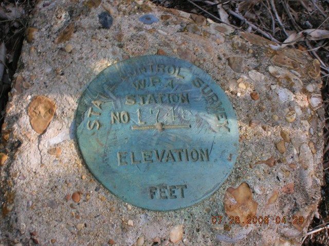
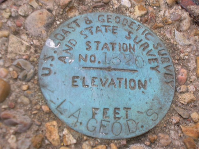
Those 2 bottom disks types were placed in every state just about as part of the WPA funding in the 30's. Lots of them were set around where I live.
Thanks Z15. That confirms my thoughts that the reset from 1970 was using a recycled disk, if the WPA types were set out in the 30's.....and helps explain the low fine.
fyi
This doc summarizes work done in all states..who was in charge etc
About midway thru this next doc they discuss the WPA projects
Thanks for those links Z15. That is interesting reading. I liked it.
I saw our own DaveD's name on the letterhead at the beginning. Apparently he does more at the NGS than just make television appearances.
-
Hi i'm katie
 and i just moved to the biloxi area and was wondering if there is a group i can join let me know i would love to meet some people
 Hi Katie, you might get a better response by posting this on the Mississippi geocachers site, which is www.msga.net
Bobby
-
Those 2 bottom disks types were placed in every state just about as part of the WPA funding in the 30's. Lots of them were set around where I live.
Thanks Z15. That confirms my thoughts that the reset from 1970 was using a recycled disk, if the WPA types were set out in the 30's.....and helps explain the low fine.
-
Howdy Everyone. I found an interesting disk (at least to me) today. For CQ1171, there is only a $50 dollar fine for disturbing it.
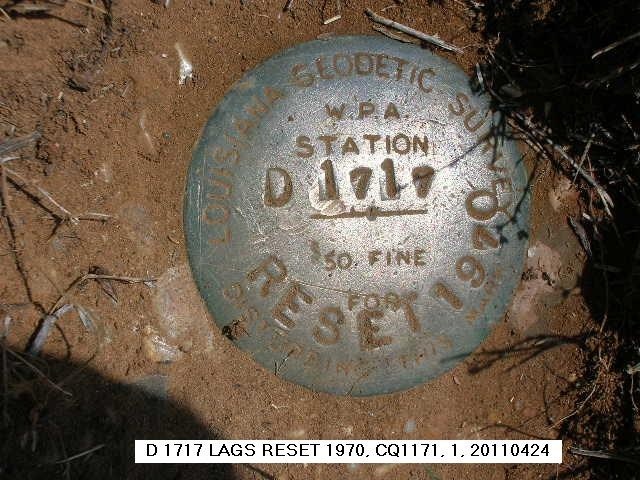
It appears to be an older disk, that I thought maybe was recycled somewhat, when it was reset in 1970. Is this something that could be considered common practice?
EDIT: As I went back over my finds for benchmarks placed by the Louisiana Geodetic Survey, it appears they used several types. The one shared with the USCGS almost looks homemade.
-
I recently started a new cache and put 4 travel bugs into it, just to promote interest. They were lifted within a few days, and replaced by 4 others. However....the other 4 disappeared without trace the next day, whereas a further one arrived, but none of these 5 were logged, either in the cache logbook or on-line. My problem is that my cache's listing page shows a wealth of trackables that just aren't there.
Here's what I've done so far....
1) Contacted the owners of all the missing travelbugs (only 1 has replied)
2) Contacted the last known person to have posession of the travelbug that mysteriously appeared in my cache, but have had no reply
3) Attempted to contact the owner of the travelbug that mysteriously appeared, but their regsitered e-mail address is no longer valid
4) Made a note on the listing page for this travelbug, saying that I'm holding it and that I will list it as 'discovered' if nobody logs it into my cache soon.
What can I do to remove from my cache's listing, all the travelbugs that are\listed as being there, but aren't there at all?
Otter, if you are the owner of the cache they are listed in, just go to the travel bug page. Make sure you are logged in to gc.com. You will see an option on the righthand side dropdown box listed under "actions" to mark the bug as missing. You'll then get a page asking you if are sure you want to mark this trackable as missing....you just click on the "agree" button and you're done. It's simple
You just need to do it for each travel bug that is showing up in your cache. The easiest way is just click on each trackable from your cache page.


NGS>>GPX needed.
in Benchmarking
Posted · Edited by LSUFan
Since FoxTrot hasn't answered and may be off checking on Route 66 marble sidewalks:
Tillamurphs, what link are you using?
Is it this one?
http://ngs.tsqmadness.com/help/index.html