


Capt. Bob
-
Posts
151 -
Joined
-
Last visited
Posts posted by Capt. Bob
-
-
...next step is figuring out a good way to place the labels on the face of the container...
Try micromark.com/Decalling
-
1. Get the correct diameter steel pipe.
2. Place the end of the pipe on the rock.
3. Add about 20 lbs of down force.
4. Slowly rotate (60 rpm) while adding a trickle of water.
5. Expect about 1” to 2” depth per day of constant wear.
The water flow and rock will create its own grinding slurry causing the steel and rock will both wear down, but the rock will go quicker. This is how geodes are cut in half. With geodes however, a slowly reciprocating flat steel bar is used. It cuts and polishes the surface at the same time, but it takes patience.
BTW, stone engravings generally aren’t engraved or etched, today they are sand blasted. The stone is protected by painting on a rubber coating leaving only the characters to be “engraved” open. The rubber absorbs all the energy of the sand grit but blast away the stone. The same type of process is used to “etch” commercial grade glass wear.
-
I have a Delorme PN40 loaded with some NOAA Harbor Charts that I downloaded from Delorme (part of the $30 annual subscription). It’s easy to mark waypoints with appropriate icons on the chart, just press the waypoint button and type in a description. The PN40 also has a tide table graphics and best times for fishing/hunting (dubious value).
-
I’m facing the same dilemma. With my main GPS out for repairs, I grabbed my cheap-o, Wal-Mart special car GPS off the shelf, dusted it off, put it on the dash and, hey, it still works. Then, in desperation, I went to my “Ignore List” and opened all of the guard rail, park and grab, and D1/T1 caches I swore I would never waste my time on. I got my fix for the day.

-
I like the idea of the battery tester light too

I've never been a fan of something that has an on/off switch be the batteries itself.
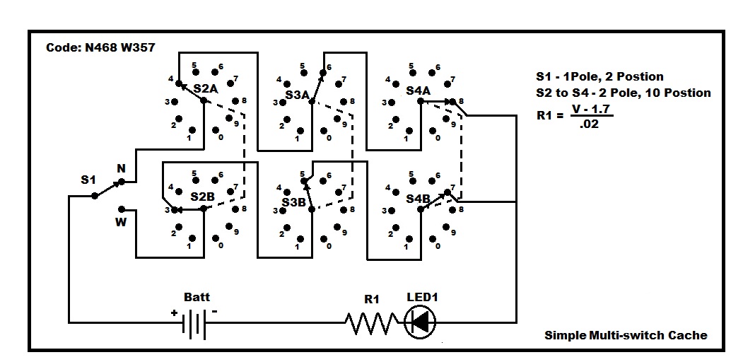
If you want to make the batteries non-removable (without being a switch function) then replace S1 with a 3 position switch. The switch should be configured as a MON-ON/OFF/MON-ON . With this design the system will always be OFF until the user manually holds the toggle switch in either the N or W position. Like I said before, the basic schematic is just that, bells and whistles are optional.

-
In my original drawing, I intended the batteries to be removed after use as I described in my earlier reply. The removal of the batteries would act as an ON/OFF switch. It’s about as simple as you can get.
-
I threw together a quick schematic for a down and dirty layout. It uses a toggle switch to select North or West coordinates allowing the use of the same set of rotary switches for each coordinate just to keep the cost down. The rotary switches, of which I only show three (you can add as many as you can afford), are rotary, 2 pole, 10 terminal type. All you do is daisy-chain the switches according to your number coding. When the code has been dialed in correctly, the LED will light. Using this method requires the user to record the dial settings before toggling to the other pole.
These type of switches aren’t that common, but you can find them on e-bay fairly cheap. Look for Rotary switches 2p, 10t. If money is no object, you could double up on all of the components and eliminate the toggle switch.
-
And the obvious question is: "How are you going to keep this thing powered?" The other observation is, if you are asking for schematics then perhaps you don't have the technical skills to bring your idea to fruition.
For a power supply try this. On your front panel attach two empty “AA” battery holders in series. The cacher will have to use their GPS’s batteries, or spare ones if they have them, to power-up the system. A little backwoods MacGyvering on their part. This avoids dead winter batteries and users forgetting to turn the system off.
-
This is my take on it: GC23TJP
Hint (don’t tell anyone!):
http://zxing.org/w/decode.jspx
and
http://www.morovia.com/free-online-barcode...rcode-maker.php
-
I did a quick look at the dilution of position for Erie, PA on 6/13/10 using Trimble's software. At the time you were having problems, 10:00AM, the DOP was the least (meaning very good positioning).
 Maybe Eerie, PA? Must have been a local phenomenon.
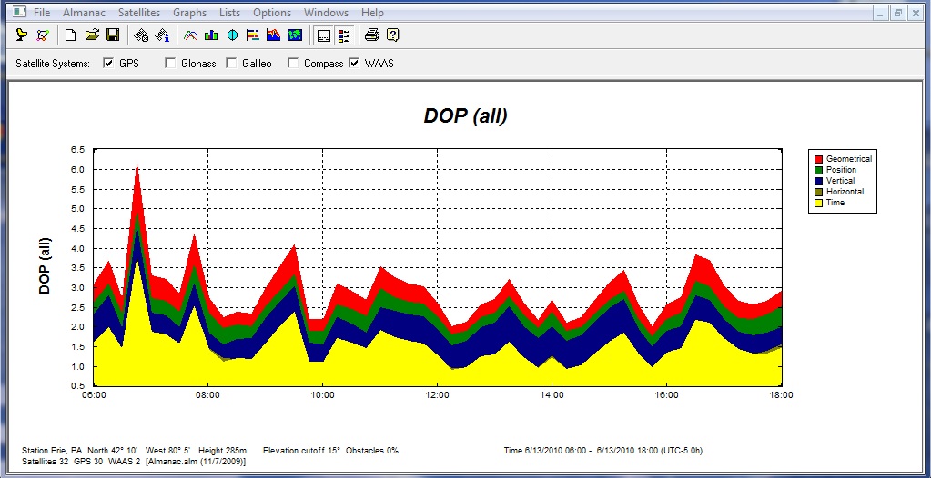
-
I thought Groundspeak’s “528 rule” was specifically enacted to prevent this very problem, i.e., “the dilution of signal strength due to cache placement proximity”. As everyone knows, dilution of signal, or more commonly known as DOS, has been the source of many problems for a long, long time.
Slightly OT, if Groundspeak enacts a new signal sharing policy where premium members have priority over non-members, will platinum members still have exclusive access to the “enhanced accuracy” signals? Also, will this have any effect on the platinum’s “FTF advantage program” of pre-published cache notifications?
-
*Team KORFUS give a big Homer Simpson DOH! YOU GOT ME, that was an Aprils Fool post* I have not fell for one in over 25 years, you ruined my streak!

This is no joke. I’m old enough to remember when magnetic compasses were all the rage and the devastating affect they had on the earth’s magnetic field. Deviations and variations of ten, fifteen, even twenty degrees in some areas were the disastrous results that we still live with today. Signal sharing seems like a good idea whose time has come.
-
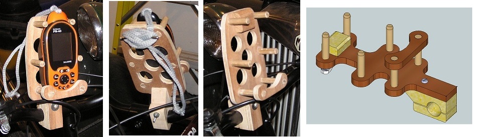
Here are some pictures of a prototype holder I built using some scrap plywood and 3/8” dowels. By using a store bought shade cleat mounted on the back to attach the GPS’s lanyard, the unit can be taken on/off in a few seconds. It really holds everything securely in place and I’ve been over some rough terrain.
As you can see, I am working on a more compact design.
-
Thanks for the tip. I tried using Scotch-brite and it worked well enough. So I’ll leave it at that for the time being before going back to Home De-pot.

BTW, I was able to complete the 3/8” slot using a router and a wooden fixture to hold it securely. On my first try I started too fast and cracked the tube. Slow and steady works nicely. Next, the tumblers.
-
I’ve started working on this project also; a nice set of plans and a nice winter project. Thank you.
The coefficient of thermal expansion for PVC is approximately 2.8 x 10^-5 in/in-°F. Therefore a 10” long piece of PVC tubing will expand 0.0028” for every 10°F rise in temperature. However, if all of the parts are made of the same material and allowed to reach thermal equilibrium, there shouldn’t be a binding problem as all parts expand and contract uniformly. Dirt and grit may cause a bigger problem due to the soft nature of PVC.
I used a wood lathe to turn down the ¾” dia. key tube to fit the 1” dia. tube. I put slip caps on the ends to hold the tube and provide pivot points. Standard wood turning tools worked just fine. After sanding I still have a rough surface that attracts dirt. How do you finish a sanded surface? Any tips?
Now on to the 3/8” slot.
-
I had a GPS315 for many years and it was a good gpsr for its time. It is accurate, acquires satellites quickly and very reliable. You will need to use the proprietary data cable that comes with the unit to connect to your computer via RS232 protocol or an usb emulator. You will also need a program, such as EasyGPS (free version) to download PQ’s to the unit.
One idiosyncrasy of the 315 is that it limits the waypoint display to six characters. Therefore, a GC number “GC12ABC” will be truncated to “GC12AB”. To overcome this issue you can select in EasyGPS to delete the “GC” and the display will be “12ABC”. That, and icon selection to indicate cache type, is about all the information you can store on the 315. I used a cheap PDA (Z22) along with the 315 when out in the field for paperless caching.
I would probably still be using it today but a kitchen table top and gravity conspired against me.
-
-
1 Minute of Latitude = 1 Nautical Mile
1 Nautical Mile = 6,076.1 Feet
1 Minute of Latitude = 6,076.1 Feet
1 Minute of Longitude = 6,076.1 Feet X Cos(Latitude)
Example:
0.001 Minutes at N42°degrees Latitude
0.001 Minutes of Latitude = 0.001 X 6,076.1 = 6.076 Feet
0.001 Minutes of Longitude = 0.001 x 6,076.1 x Cos(42°) = 4.515 Feet
-
Consider a compass that has allows for declination correction to automatically give you true north readings, and one filled with a dampening fluid to keep the arrow steady. They are generally a little more expensive, but worth it.
-
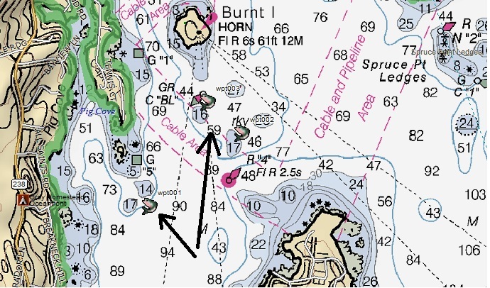
GC1AP5R - Submerged
GC1WKGM - TSLSSL Hydrocache
-
I used a 315 for may years and found "Geobuddy" software to work nicely. The only issue is the size limit of the Waypoint ID. Using the program, you can strip the "GC" from the Waypoint IDs when loading the gpx files to the program.
-
I don't have GSAK so I wrote my own program to replace the owner's name with the cache ID while in the .gpx format. This now places the ID in the comments area.
-
I've downloaded many Pocket Queries in the .gpx format directly into Topo7. Then easily sync Topo7 and PN-40. No problems there. What bugs me is Topo7 only displays the cache title but not the cache ID. In fact, the cache ID is lost in the transferred to Topo7. I miss not having the cache ID's when logging my finds.
-
I'm guessing everyone got the same email...mid-November is the new ship date, if you consider "mid" a date.


Submerged GeoCaches (underwater) containers
in General geocaching topics
Posted
A container that can keep water out usually can keep water in. So anyone who opens any type of container that’s been underwater will more than likely drip water inside where is bound to stay and cause trouble.
The best underwater cache I’ve seen is a multi-cache, where part 1 is just a metal tag with the final’s coordinates stamped on it. Something along the lines of this one: http: http://coord.info/GC1YA42