


Capt. Bob
-
Posts
151 -
Joined
-
Last visited
Posts posted by Capt. Bob
-
-
9 hours ago, Raysfan39 said:
New here. Anyone know when they will unlock it to log the code?
I hope the TB is unlocked before the Chinese rover, Tianwen-1, lands and grabs the coin next month. Will China keep it or move it on?
-
.png) 6
6
-
-
Here is a simple explanation to answer your L5 question.
https://spectrum.ieee.org/semiconductors/design/superaccurate-gps-coming-to-smartphones-in-2018
-
On 2/6/2021 at 6:11 PM, Mineral2 said:
I guess I don't understand the differences between the L1 and L5 signals, but if they are coming from the same satellite at the same time, wouldn't they both reflect?
Radio waves only travel at the same speed (speed of light) in a vacuum but are slowed when traveling through the atmosphere. The two signals, L1 and L5, use different frequencies and are affected differently by the atmosphere that results in different travel times. That difference can be used to correct for atmospheric induced errors to improve timing accuracy.
Here’s an analogy. Suppose you have a steel rod that is exactly twenty feet long and you want to accurately measure your backyard, but in the cool morning it is one length and longer in the hot afternoon. It also changes length even if a cloud drifts overhead. To overcome this problem you place a brass rod right next to the steel rod with one end of both rods affixed to each other. The brass rod is one inch shorter than the steel rod. Now they both heat and cool together and the difference in length at the one inch cut is proportional to the entire length so the true length of the steel rod can be determined regardless of temperature.-
.png) 1
1
-
-
13 hours ago, NYPaddleCacher said:
That's not true in the case of cache located in place that are legally closed to public access during the winter, or do you consider a cache to be "available" even requires breaking the law to find it?
Yes, I feel that "Available in winter" only refers to physical access. "Seasonal access" refers to the legality of access, i.e. the park is closed in winter.
-
1
-
 1
1
-
-
Anything can be “Available in winter”, it just may take more effort. (https://en.wikipedia.org/wiki/Glacier_Girl)
Perhaps the definition “Available in winter” should be changed to “May require snow/ice removal”
-
1
-
-
6 hours ago, Cheminer Will said:
I did not see that anyone had an answer to why that map is covered with "NR"s? Here is a screenshot so it is obvious what I am referring to. Anyone know?
https://help.openstreetmap.org/questions/5972/what-does-nr-on-a-map-mean
-
On 10/18/2020 at 6:29 PM, Viajero Perdido said:

Four constellations all contributing to the fix! Also (off the screen), WAAS is being received but oddly, there's no U flag indicating it's contributing to the fix. The app shows it cycling through about 6 different SBASs trying for a signal, but here in Canada, only manages to find WAAS.
Does the BV9900 Pro allow you to set a higher satellite masking angle? From the screenshot it looks like it is factory set at less than a 5° angle. Since you really only need four well spaced satellites to get an accurate solution these should be easier to attain with such a large number of available satellites. A higher masking angle of 25° to 30° would mitigate multi-path errors and atmospheric refraction to produce a smaller (better) DOP. I'm assuming it is possible to combine four satellites from different constellations.
-
I noticed the device suggested by ecanderson uses a LDR (light-dependant resistor, also called photocell). Any light detecting sensor (LDR, photodiode, phototransistor) requires an active electronic circuit to operate. In other words, some power is being consumed (quiescent power) whether it detects light or not. That is why the device includes an On-Off switch to disconnect the batteries when not in use.
When you get tired of replacing batteries you might consider replacing the LDR with a jumper wire (LDR’s are high resistance when dark, low resistance when light). Then remove the On-Off switch and replace it with either physical electrical contacts, or a tilt sensor (https://www.sparkfun.com/products/10289), or a magnetic reed switch (https://www.sparkfun.com/products/10601) that will kill all power to the device until it is needed.-
1
-
1
-
-
11 hours ago, ecanderson said:
42 33.868 works for me. Round it up or down (up, using the classic method for your example). It's all of the information I could possibly believe in the field. Give or take +/- 4 feet (0.001) at my latitude is typically more accuracy than I can hope for in any case. I am NOT 'confident' of the third decimal place in any practical sense.
I agree with you that three decimal places are sufficient for most non-professional uses. However, if your GPSr has a built in accuracy error of a 4 foot radius (search area = π* 4^2 = 50 sq. ft.) that’s good, but in reality you don’t. Suppose the CO uses the same GPSr as yours then the placement error could possibly be a combined 8 foot radius error (search area = π* 8^2 = 201 sq. ft.). However, we use an X-Y coordinate system so an 8 foot radius becomes a square with 16 foot sides (search area = 16 x 16 = 256 sq. ft. or 5 times larger than first thought).
-
Take a look at one of your track files (.gps). This is sample track point of a recent hike I took: lat="42.5644593313" lon="-73.0413549766". Each track point in the file is calculated to ten decimal places. (Converting decimal-degree to degree-minutes produces 42° 33.86755988’, 73° 2.481298596’). Why so many decimal points? I think what your GPS is telling you is that its CPU is very precise. It not saying it is accurate, it knows nothing about accuracy, and it only knows how to precisely convert the data it receives into readable coordinates. If the data is bad then accuracy suffers but not the precision.
When Geocaching only three decimal places are necessary. So why show four decimal places? It is to show the confidence level of the third decimal place. So, for example, using the latitude from above 42° 33.86755988’ should the minutes be displayed as 33.867 or 33.868 or 33.8675? With only three decimal places the user can assume the unit rounds up the last decimal place but the user can’t be sure. By showing four decimal places the user is confident of the third decimal place. (This is a good policy when selling your product internationally.)
-
1
-
-
If you receive permission you might consider making the cache a Multi or Mystery by attaching two metal tags (engraved brass plate or pet ID tag) to two separate posts. One tag inscribed with the last 3 to 5 digits of latitude (Stage 1) and the other for longitude (Stage 2), or both numbers on only one tag. The final can be placed elsewhere within 2 miles of these tags. Initially you may pay more for the tags but maintenance will not be an issue plus the tags will only be recognizable to Geocachers and less likely muggled. The owner of the obstacle course may enjoy the fact that the course will become a physical plus a mental challenge.
-
2
-
2
-
.png) 1
1
-
-
14 hours ago, T-BearNose39 said:
is everyone having trouble with satellite reception the last few days or is it just me in Tucson with my 2 Garmins?
Yes, here in Massachusetts, on Oct. 9, it took over 30 minutes for my car’s nuvi to acquire enough satellites to work and, at the same time, my 64st would not acquire any signals until I turned off the Ruski’s satellites and went with just GPS. After locking on to the GPS signals only, I tried adding Glonass again. I watched as the EPE slowly degraded from ±4 to ±65 to ±120 to ±237 meters... before reverting back to GPS only. This same problem has occurred two times before over the past three months.
The next day I fired up my old Delorme PN-60w that has been sitting in a draw for those three months. Even with the unresolved “End of Week” issue (date 1999) and an outdated almanac I was able to acquire satellites in 15 minutes and soon had an EPE of ±3 meters. (Love my Delorme, not so much Garmin).
-
Computers use decimal degrees to perform their calculations and GPSr's are computers. Humans prefer degree/minute formats. If you enter coordinates using DD MM.MMM they will be converted internally to DD.DDDDDD. Take a look at a typical GPX file and you will see the coordinates are in decimal degrees, up to six decimal places, e.g. <wpt lat="42.155317" lon="-72.328767">. So in this case, if you entered 42° 09.319’ your computer will convert it: 42° + (09.319’ / 60’) = 42.155317. After the computer determines a solution it will convert its answer back into degree/minutes: 42° + (60 * 155317) = 42° 9.319020 for display purposes. The number of decimal points displayed to the user indicates the precision of the GPSr’s solution, not its accuracy. Which is better to display to the user, 9.319 or 9.3190? With the number 9.319 being displayed the fourth decimal place could be less than 5 or greater than 5. You are assuming (or you're guessing) it is less than 5, but you don’t know for sure. When it displays 9.3190 you know for sure that 9.319 is definitive and correct.
-
1
-
-
Did you check the " Ignore logs before..." date? My page has been using the year 2078 for the past several months so I just uncheck the ignore box. Why 2078? I don't know, but it must be stuck in a 'cookie' somewhere.

-
I recommend this video that explains precision, accuracy, measurement and significant figures in a simple, easy to watch format.
https://www.youtube.com/watch?v=b38hFWvEjwI
-
Of course you may have a different reading at different times. There are a myriad of reasons for variations in readings. Garbage in equal garbage out. However each reading it takes at that specific moment has a precision level displayed by the fourth digit even if the data it receives is bad data. So garbage in equal very precise garbage out.
The final (fourth) digit does carry useful information. It tells you the certainty of the third digit. Suppose you have a three digit display and the third digit varies. Example: 659, 658, 657, 659...etc. Now what is your confidence level? You should feel the '65' portion is accurate but unsure about the final digit. The same thing applies to a four digit display.
-
3 hours ago, barefootjeff said:
The fourth digit isn't from a random number generator but it might as well be as it's just reflecting what is effectively system noise. By way of experiment, I took my Oregon 700 down to the beach, where it had essentially an unobstructed view of the sky, and recorded the decimal part of the minutes of latitude over about half an hour. These are the results:
6590, 6594, 6593, 6597, 6597, 6599, 6599, 6597, 6595, 6592, 6593, 6590, 6592, 6593, 6593, 6593, 6592, 6592, 6593, 6595, 6595, 6595, 6592, 6591, 6590
For that fourth digit, what is the correct value? Pick a number, any number, and at some point you'll be right. They're varying slowly but they're essentially random, and I'm sure if I went back down there tomorrow morning with a different constellation of satellites visible I'd get a difference of at least one or two in the third decimal place, rendering anything in the fourth decimal place utterly meaningless.
What your four decimal digit GPSr is telling you is that its level of precision is limited to three decimal places. The fourth decimal place is a guess, or in your case, perhaps random noise. However, you are assured the number 659 is an accurate number.
Suppose your GPSr only displayed three digits. If the fourth decimal place (now hidden from view) is below five the display will be 659 but if the fourth decimal place is above five it will display 660 due to a rounding error. What if the unit does not round up? Then if the fourth decimal happens to vary between 5 and 9 the unit will only display 659 and not 660 which would be closer to the actual location.
The fourth decimal place is telling you the precision level of your GPSr and it’s up to the user to decide the final number. However, commercial grade GPSr makes it simpler for the average user by dumbing down the display to only three decimal places.
-
Engineers understand that the last digit (and only the last digit) in a measurement is an estimate. By writing 25.45 cm, you indicate that you are sure that the measurement was between 25.4 cm and 25.5 cm, and you estimate that it was about 5/10 of the way between them. Therefore coordinates should be written to four decimal places to indicate you are sure the measurement is correct to three decimal places and the fourth decimal place is only a guess or only three significant figures.
-
1
-
-
14 hours ago, The Waysiders said:
I'm happy I stumbled on this post. Thank you! My PN-60 still works but the "1999" date is a bit disconcerting. I'll try the update tonight when I get home. Now if I could just find a replacement data/recharging cable ….
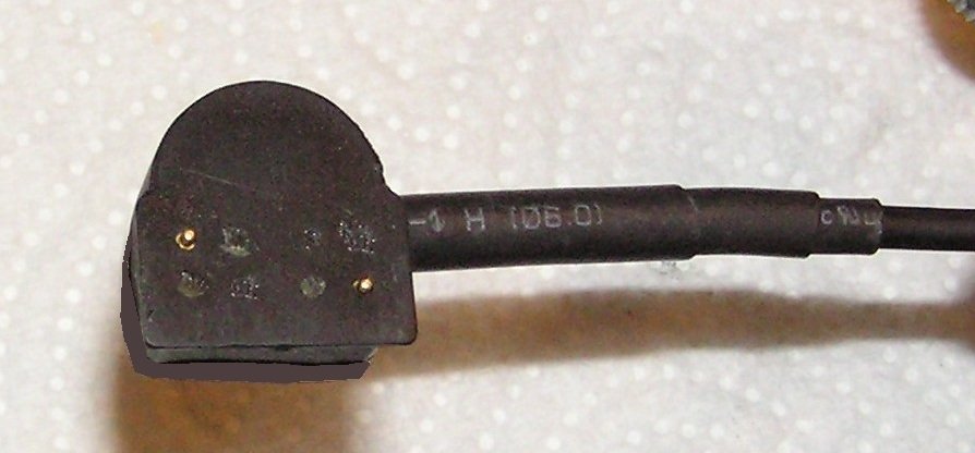
Generally there are two cable failure modes. Broken wires at the connector due to bending fatigue or the spring loaded contact pins become inoperable due to contamination.
Sometimes the broken wires can be cut, soldered together and covered with a heat shrink tube. The contact pins can be sprayed with WD-40 and worked until they are free to retract and extend. Both of these solutions are only temporary fixes.

I found that taking apart the connector and replacing the contact pins with larger ones (large contact area and heavier spring) then adding several layers of heat shrink tubing is a permanent solution. I did both data and re-charge cables many years ago (~ 5 yrs) and haven’t had a problem since . The conversion is not that difficult but soldering is required.
.jpg.94a48de22630df622e18bb148dfcd7b9.jpg)
-
1
-
-
On 4/26/2019 at 1:06 PM, dprovan said:
I updated my PN-60w and it seems to work fine. Two caveats, though. First, I don't use the "w" (i.e., in-reach or the older spot), so I have no idea whether that feature still works. Second, Santa brought me a Garmin 66s since at the time it looked like there wasn't going to be a firmware update (and, besides, my PN-60w's seen better days), so I don't use my PN-60w as much as I used to, but I've used it enough. (And I sure do miss it.)
I saw nothing anywhere in the update that mentioned the "w" or gave me any sense that it was considered, so it might be just luck that it works.
Thanks for reminding me to un-check the “Wireless Antenna On” setting. Afterwards, I used the PN-60w for several hours yesterday and did not have any unexpected reboots. However, I had to do a NVM reboot due to overlapping satellite data (two or more satellites shown to be at the same location) where the EPE went from +/- 3m to +/- 34m! Somehow the almanac data become corrupted. This leads me to believe a corrupted almanac, or lack of, may be the cause of slow satellite acquisitions at startup.
-
13 hours ago, Mn-treker said:
Only the PN60 can take the update. No update will be made available for the others.
I wonder if that holds true for PN-60w also?
I have a PN-60w and it has been updated to ver. 3.7 firmware which has corrected the EOW error. However, the unit now suffers from occasional, spontaneous, re-boots and, at times, a corrupted almanac that requires a NVM reboot to correct. It also seems to take longer to acquire satellite fixes on the first startup of the day. I’m beginning to think the memory map of PN-60w may differ from the PN-60. Has anyone else using an updated PN-60w have these same issues?
-
On 12/27/2018 at 1:22 PM, Mn-treker said:
I have read about taking the head apart and doing a repair inside. Also those pins are spring loaded . Try air in a spray can and a little contact cleaner on cotton swab. Then clean the pads on the GPS. If you have a cigarette lighter
Charger that is broken. Open it up, you will find a coil with broken wire going into the PC board. Fix that and good to go.
I found the USB cable has two failure modes. One involves the contact pins failure to make contact to the PN-xx receiver and the other is broken wires at the connector. I corrected both issues by replacing the original pins with larger ones and at the same time added better strain relief using heat shrink tubing. The larger pins have more contact area, longer plunger travel and less apt to sticking. I modified both USB data and automobile power cables in 2012 and haven’t experienced any connection issue since.
.thumb.jpg.c44f0862267a1672bf8f46a2f0d18185.jpg)
-
2
-
-
Looks like Garmin has released v3.7 to cure the 1999 EOW issue. This updated firmware with replace v3.6.
https://support.garmin.com/en-US/?faq=dXCDWk3aIZ3A0Ly9z8uym5
-
1
-
-
If your PNXX is displaying a date that ends in 1999 then a v3.6 firmware update will not correct that issue. The problem is an End of Week (EOW) rollover and, as of now, neither Delorme nor Garmin intend to bring the PNXX into compliance.
.png)
.png)


.png)


.jpg.94a48de22630df622e18bb148dfcd7b9.jpg)
.jpg.c410d43e7d79bc9389a70237a6b6b413.jpg)

Using Multiple handheld GPS units with Topo 7, or 9
in GPS technology and devices
Posted
I have a PN-40, PN-60 and PN-60w all using the same Topo 9 mapping software but loaded on to individual SD cards. I don't have any mapping software loaded in "Internal Memory".