


AndrewRJ
-
Posts
1232 -
Joined
-
Last visited
Posts posted by AndrewRJ
-
-
Those who keep track of all the tools available may want to scan this thread on the Point Of Beginning site for professional surveyors.
They don't realize that one of the recommended tools comes from a ______ geocacher". I reread their thread on the newbie who logged to NGS that his handheld was better than a tri station, and I still cringe.
Wow, makes us seem civilized, Although I cringe when I see a statement like that being made by someone with my name.
and I think he got it backwards, some of us are hack surveyors, but phenomenal geocachers.

-
Ok I will bite.
You have written to the appropriate age group. You could use a few more geologic terms (with appropriate definitions) Something like hardpan or ouklip is a general term for a dense layer of soil, usually found below the uppermost topsoil layer
I also found this sentence poorly constucted
I think you are talking about the lack of fresh soil formation and the lack of nutrient migration from upland environments, which also will retard plant growt, but over all you are not talking to people with B.S, M.S, and PHD's and that is good. You seem to have your information geared twoards the everyday person.No new soil is created and there is no higher terrace to drain in.I really like the track log idea, it is easy to look at and see the terraces when compleated and it proves that the person was there. It is also a great example of a learning activity that doesn't involve reading a sign.
I don't care for most of question 5, overall it really is just read a sign and take a photo to prove you are there, not really high on the educational factor. (there are a few like that in Washington where the needed info is in the first line of the write up and then you take a photo. I look at this as an interesting virt, but not an EC)
I think you did a great job and I do mean for these comments to be taken constructively and not negatively.
-
As long as it isn't March 1 even I may make it over for this one.
-
I may be wrong here, but I think that bug went to TL's brain.

I think he was asking from the trail head to the APE cache, not the lake.
-
[
Also if you click on the Review Forum Signature link you only get a blank box
 Signature: Review Forum Signature
Thats because you don't have a forum signature to review
-
WOW! That is quite an adventure. Very cool that you were allowed onto the dam property to recover those.
-
Doesn't Sunrise in Woodinville allow you to pick up things there that you order online to save on shipping?
Yes they do, or at least they did the last time I ordered.
This has actually changed, since we ship in house now so there isn't the same "will call" option that used to be available.
I'm not sure about the other REI stores, but the flagship does carry some geocaching products.
Thats too bad as the store was quite convenient to pick up at.
-
I did a cache once where the hider did give trail head coordinates and after a couple of miles of hiking later I came to the cache near a road(the Pittock Mansion parking lot actually).Giving a description of the cache location(roadside) or how to get there(parking coordinates) or anything that helps future finders is considered spoiling. Some finders don't read logs before hand. Some hiders don't like spoiler logs. In my opinion, the hiders weren't trying to criticize you, but were showing their preference for no spoiler logs.
I agree that the e-mail could have been better worded, but I have an honest question here. How is saying it is a roadside cache a spoiler?
What I am saying, I guess, is if you read the log that said it was by a road, did you not also look at the google map on the page. Usually even if parking coords are given it would be aparent that it was by the road by looking at the page. I guess I just don't see what his Origional log said that about 3 or 4 other logs hadn't already said that was excessivily spoiling the cache.
Trailhead coords are a little different, I understand that the owner may have wanted you to hike in a specific way to see something interesting and not taken the shortest route.
-
By the strangest of coincidences I went to a Super Bowl party with one of the Engineers that evaluated those tunnels that caused the parks to close them.
Based on some of the info and photos I saw, there are some very hazardous areas in each of the tunnels and many area where the shotcrete skin and rocks in the tunnels are about to come down. I also know that some design build plans are in the works to repaire them. -
Giving a description of the cache location(roadside) or how to get there(parking coordinates) or anything that helps future finders is considered spoiling. Some finders don't read logs before hand. Some hiders don't like spoiler logs. In my opinion, the hiders weren't trying to criticize you, but were showing their preference for no spoiler logs.
I agree that the e-mail could have been better worded, but I have an honest question here. How is saying it is a roadside cache a spoiler?
Is there only one type of roadside hide over in Wenatchee? I mean he didn't say it was hanging from the third branch in the maple tree; a quick look on a map or a drive by would show that it is on the side of the road. When you pull up you are going to see the same thing.
-
This raises the question: What is cache etiquette.
Gene,
It's hard to tell exactly what your question is regarding cache etiquette. However, being on the subject of etiquette I thought I'd mention that I consider it poor form to take personal issues like this to the forums. You should be dealing with the cache owner and not involving a community of people who have only heard your side of the story. And, I'm no diplomat, but starting your response with "What is your problem?" is in no way a "very diplomatic" way of approaching anything.
As is hiding behing a sock puppet and posting SBA notes with them
Just consitering the iorny here. -
Trimble announced that Trimble Outdoors is available on some Verizon phones today. No word on Geocaching Navigator (I've asked on their forums) yet.
6 bucks a month, not for me.
-
OK, looking at this from a public safety standpoint, I have to see their point. As a firefighter for 25 years, a medic for just as long, I have my degree in Criminology(I know, Why are there cops, so firefighters can have hero's), I have been involved in Emergency Management for the last 10 years, and if it looks like a bomb, smells like a bomb, and feels like a bomb, ya blow it up. It is easy to look at the list on GC.com and say, OK it is a cache, but what if it isn't? A camo container can't be seen through, so how do you REALLY know what is in it. We have to err on the side of caution. While I realize that a small container isn't going o pack much explosive, to a beginning bomber, that is a good way to start to see how explosives work. If we all followed the rules and used a CLEAR container, it would be less of an issue, but people use ammo cans, pvc pipe and other things that can be misconstrued by the public.
I responded to a house, the new owner found an ammo can in the back yard behind a shed under a milk crate. Possible cache right? WRONG, the ammo can contained hand gernades the previous owner brought home from Nam and never disposed of right.
You never really know what is in the container, it could be a home made bomb, poison, anything. Cambria county just had an incident where a drug dealer dropped his stash in the woods, the buyer paid for the cords, and off they went to pick up the prize(Sounds like caching) What if that dealer wanted to take out the competition? booby trap it and bye bye bad guy. Too many possibilities out there in this screwed up world. You never kn ow when ya might run into the next McVeigh or Kazinski. Just my thoughts from a public safety view.
Well I wouldn't call myself a noob, but what rule do you speak of?
 I am interested to see the no ammo can rule
 -
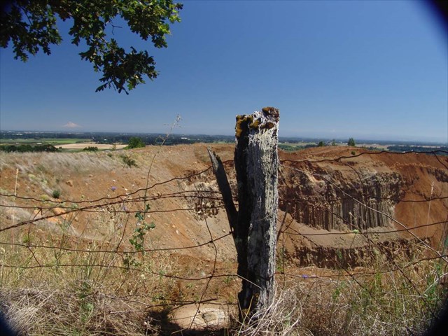
My friend Mega Scooter took this photo while on the hunt for a benchmark named
Hold near a rock quarry. Unfortunately the quarry's activity has nearly disturbed a RM. If you look closely you can see Mt. Hood on the horizon.
This thread is filled with killer photos! Keep up the good work.
—Malnut—
Looks like a very nice columner basalt outcrop as well.
-
Girls go to Eddie's too.
Yep, just not tonight for most of us - glad you were there to keep them in line.

Too bad, you girls missed their new improved sweet potato fries.
Forget the fries, were they breaking in a new cook this time? Like every other time we have gone?
-
The Colorado and Oregon have the ability to hold three separate mapsets: the default TopoUS 2008 map, an additional mapset in internal memory, and a mapset on the SD card. I keep the bulk of my maps on the SD card and use the internal memory for loading of maps that i update frequently, like Northwest Trails. This allows me to update to a new version of NWT in a couple of minutes rather than the hour+ it would take to upload all mapsets at once.
Is this exclusive to those units, or can the GPSmap 60 units do it too - upload maps separately to memory and the data card? I'd sure love to be able to upload NW Trails more frequently, without spending a half hour reloading the entire mapset.
from what I understand this is just the Colorado and the Oregon. I wish it was for other units, I also have to reload everything.
-
I am a definite again, the extra rest did a world of good and I am feeling much better.
-
a question did come to mind - are the trails going to be included with the topo map? I can see possibly wanting just the topo without the trails. Would loading both topo's with trails and the trail maps (overlaping regions) cause any problems?
I'm not sure why one would want topo without trails.
So that you could use the topo sort of like a basemap and use an alternate source for trails which could be updated much more frequently. Sounds like that's the plan here.
Well since, for Garmin anyway, you have to reload all the different mapsets to update any one of them you can't really use the topo like a base map.
And how can any trail map get updated more frequently than NWTrails. Sheesh!
For the newer units like the Colorado you can actually just update the map file without having to upload the basemap file.
-
Since you have to sign the Climber's Register before hiking Mount Saint Helens, do you have to go all the way back from the Hikers Bivoac to The Lone Fir Resort to sign the Register, then back to the trailhead at the Bivoac, or can you sign the register the night before when you are picking up your ticket(s) and Bivoac permit at the Lone Fir Resort?
I remember signing it the night before.
-
Current attendees for January HOTM (Strung Out):
TotemLake (3 w/colleagues)
SquareBear (Ray)
hydnsek
lucyandrickie (2)
Cache Ahead
Cstmfrmr (4 w/daughters and bfs)
Ironman
LandRover
AndrewRJ
Criminal
Prying Pandora
Plaidguy
MtnMutt
LittleBlue
Allanon
Still 20, although TotemLake said two are now maybes (don't know who).
Make that a third maybe. I need to try to shake this chest cold a little. If I don't feel any better I may bail, but I am going to call in tomorrow and rest so I hope I will make it.
-
-
Just guessing but I think that FrodoB would be the FTF.
That said, I am only about 40 away at this point, and I need a boat.
Yah, my money's on FrodoB too.
And several of us have kayaks that could be loaned, so there goes that excuse.

I just pulled up MTB filter. Apparently I have 69 left. But here is what I did discover. The filter leaves off 163 houses, Sunken Forest EC and the other cache there.
So where are you going to call the boundaries of Bellevue, the middle of the lake? or...
Also some of those 69 caches are disabled which would be a large nuisance if that was all you have left. Just a few other things to think about.
-
-
What fun! My son has passed out of the fossil-loving phase, but I'm still stuck in it. Here are a few caches that are fascinating for the budding geologist (and a couple are in your old neighborhood). I'll give you the names , sorry, don't know how to make it a hyperlink.
Ferns, GCV290. Lots of plant fossils, right next to the road. Cache is not too far northwest of Oliver, BC.
Balancing Rock: GCPHW0. A couple of mile east of Oliver, toward Baldy. No fossils, but very cool.
Erratic Behavior: GCQWV6. South end of Omak Lake. You probably know the place. If your son hasn't seen it yet, he'll love it.
In Oregon, I really recommend visiting Fossil, Oregon, if you haven't been there already. The town has a fossil bed right behind the high school where you can just dig in - literally. It's pretty close to John Day Fossil Beds, there's near by camping, and the John Day River is nice for swimming.
I have been to Fossil Oregon. I have a very nice leaf imprint collection from there. I would also sugest the EarthCache in Bellingham that is owned by Half Canadian. There are some very large fossil imprints in the sandstone.
 I am interested to see the no ammo can rule
Hike of the Month 2009
in Northwest
Posted
I may be there as well depending on location.