


Iowa Tom
-
Posts
477 -
Joined
-
Last visited
Posts posted by Iowa Tom
-
-
Does anyone know if the satellite status screen lists all the GPS satellites above the horizon or is there an above 5 degree low limit etc? My Magellan showed one that was, according to CalSky, only 8 degrees above the horizon. It did not show one that was 6 degrees up though.
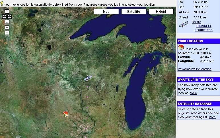
You can check your own GPS screen with the list of what's up for your IP address here?. Simply adjust the Minimum elevation of satellites then hit “Now.”
I noticed (for the first time) tonight that just as CalSky starts with the highest altitude sat on top so my Magellan starts with the highest sat on the left in the list at the bottom of the screen.

-it
-
Well...I see that I'm over the hill. I would rather be over it than under it though.

-it
-
If all goes well, I might be able to get a geocoin up on a Space Shuttle flight this coming November/December.
What I want to know is, is this a "who you know" thing? How did you arrange this?
I once worked on an event with Don Pettit while he was aboard the ISS. I tried to signal him with a large mirror. I was in Waterloo, IA and he was in orbit. For me it was one of those who you know things.
-it
-
-
What I’m going to do at the time of this flare is, not only will I observe the satellite directly, but I will have J-Track 3D up on my laptop using wireless outside. I’ll have Iridium 57 “selected” and “centered” and as the flare occurs and I will see where it is with respect to my location. I have planetarium software that will do a lot better job but I would like to see how J-Track 3D works live in this situation. Secondly I will also go to this website to see where it’s at. Lastly I will click on this URL as well.
I saw the flare and observed the satellite's position using this this website. It's position compared to my position, the house, at the time of the flare, is shown below. I forgot to use J-Track!
-
Here's a link with all the successful real SATS now in orbit.
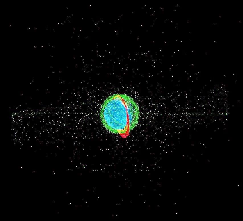
J-Track 3D does not show all the operational satellites in orbit. It is selective. Here's an image I made showing a lot more of the stuff that's up there. The green haze close to the earth are low earth satellites.
I'm currently writing curriculum about satellites and their orbits and do find J-Track 3D to be very useful! Just today I discovered a fun trick that I didn’t realize that a person can do with it. Try this, click on this URL then under “Satellite” and “Select” highlight the top satellite in the list. Then press and hold down the down arrow on your keyboard. A fast computer will produce quite a show. I find it especially informative when the GPS and COSMOS satellite orbital planes are displayed one after the other. The Iridiums occupy many planes as well. I especially like watching for the highly eccentric orbits like the one for DOUBLESTAR (TC-1).
Tonight at my location I will see a magnitude -4 flare from the Iridium 57 satellite. Flares from these satellites are not uncommon but the really bright ones, e.g. up to magnitude -8 or -9, don’t occur often at any one location, aside from the poles that is, and then only at certain times of the year. Here's a picture I took of a -8 Iridium flare that occurred over my place the other day.
What I’m going to do at the time of this flare is, not only will I observe the satellite directly, but I will have J-Track 3D up on my laptop using wireless outside. I’ll have Iridium 57 “selected” and “centered” and as the flare occurs and I will see where it is with respect to my location. I have planetarium software that will do a lot better job but I would like to see how J-Track 3D works live in this situation. Secondly I will also go to this website to see where it’s at. Lastly I will click on this URL as well.
-it
-
A friend of mine once said he had a satellite orbiting the earth and the moon for two days, at least.
-it
-
Take a look at the tutorial at Trimble.
http://www.trimble.com/gps/index.shtml
This is fun.
http://www.gpsdrawing.com/gallery.htm#land
I use GPSrs to teach the difference between accuracy and precision. Along those lines have a look at this:
http://www.visualgps.net/default.htm
-it
-
Just discovered this topic. I've been Googling "Earth to Moon Experiment" for years. I challenge my students by telling them to try to get a satellite to do a figure-8 around the earth and the moon. This applet works real well when showing the acceleration of gravity.
-it
-
I didn't read carefully. Nope. Don't have that. By the way, what happens that makes it need calibration?
The speculation is that every new set of batteries might have different magnetic properties, and therefore will cause different distortions in the compass readings, than the last set. Calibrating the electronic compass after replacing a set of batteries corrects for whatever distortion the new batteries cause.
--Larry
I just moved a battery around a compass and the needle did move. I then placed the battery against a powerful maget I have and when I brought it near the compass again it swung the needle a lot more.
Hey Larry, finally, someone that actually signs their post! Now I believe that I will too.

-it
-
I didn't read carefully. Nope. Don't have that. By the way, what happens that makes it need calibration?
-
How do you calibrate a GPSr? I use Magellan and don't know that I can do that.
-
Often times, instead of painting PVC or plastic (the paint rubs off) I do a deliberately sloppy job of wrapping the cache with camouflaged duct tape. I wrinkle it etc. Then I paint that. The tape fades to cyan if exposed to light, so by itself it's not good. However, the paint sticks well to it and even if it does come off, the tape serves as something other than white or colorless as a base. Then again, it also adds texture.
-
Just a thought.
I was wondering if the Government wants more ham radio operators in case somebody smashes or otherwise disables the communication satellites in a time of national crisis. Encouraging communication via ham radio at a time when satellite communications are out would be a good thing wouldn't it? I would think that more people would consider taking up the activity if they didn’t have to learn Morse code first.
-
Wow, that TB has a lot of wishes! I just put a watch on it. Maybe I'll think of something else that may be of help as I get reminded of its existence from time to time.
Good luck!
-
Since TBs often don't move a lot maybe you (a logged in user) could provide a URL for the latest map to the webmaster for your school. MapQuest or Google Maps would be two choices. The webmaster would have to redo the link whenever the TB moved.
There's also the possibility of making a Yahoo Group for your class. Every student would have to join. Yahoo does take out groups that don't get posts often enough. I do not remember how often posts need to be made. Everybody that belongs could get an e-mail automatically anytime a new TB entry was made by the teacher or anyone else.
-
I just went to geocaching.com, logged out, went to the geocache where I started my "Chicken Little" TB and clicked on that TB's name. Up came the webpage for it.
The page is here.
You could do the same and simply either make a link to the TB's webpage or make it so when you click on a picture of it that you will go to the appropriate place.
-
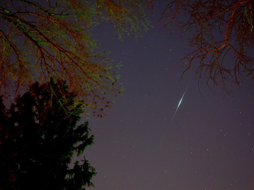
Absolutely amazing. Saw the comet, Cresent moon with pinacle star and a satalite all on the same evening from the Strand. Hopefully the pictures come out!!!!
The image below and the quotation here is from SpaceWeather.com. "Even experienced astronomers have never seen anything like it--a sweeping fan of comet dust visible to the unaided eye despite city lights and twilight. Steve Crane sends this Jan. 19th picture from Cape Town, South Africa."
I made this graphic to show what was up in the west as seen from the Cape after sunset on Jan 21st. The upward slanting lines are about a fist-width held at arm's length apart.
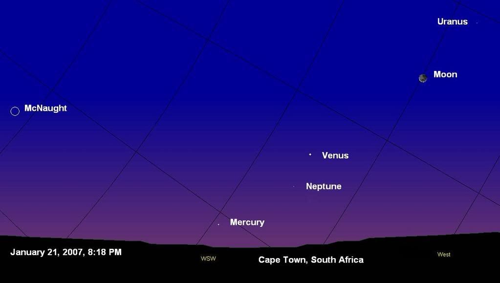
If you want to try to determine what satellite you saw go to Heavens-Above. It looks like you will have a high pass of the Space Station on Jan 30. It may even cross in front of the moon! I've seen that happen. It’s a brilliant object to watch. It'll be about as bright as Venus, the star-like object you saw.
Iowa Tom NE Iowa USA
-
Hey are you guys down there seeing Comet McNaught right now? I can hardly believe my eyes when I see the pictures coming in from the Southern Hemisphere. I only caught one glimpse of it from here in the central US before it headed south.
 I have made many geocaches that have a theme that is related to something about nature. I would think that making one about this unreal comet would be good.
-
Hey are you guys down there seeing Comet McNaught right now? I can hardly believe my eyes when I see the pictures coming in from the Southern Hemisphere. I only caught one glimpse of it from here in the central US before it headed south.
I've made many geocaches that have a theme that is related to something about nature. I would think that making one about this unreal comet would be good. -
My Dad knew Morse code pretty well. I'll never forget hearing him listen to it for hours on end.
Me, I never learned it but wanted to. As far as getting a license w/o having to learn it, that works for me. I'm so hard pressed for time that I may never take the opportunity anyway. Then again my name is duh...duh duh duh...duh duh.
As far as typing goes, I use the "Columbus method," when I find a key I land on it. So I'm out there too. -
The catch is this--in order to complete the route, they have to also incorporate clues about what they have been learning during the week.
To find the final of one of my multi-caches the players must take a short exam. The exam is in the 2nd of three containers in the series. Each of the correct answers is associated with a “good number” that will lead them to the final coord. Obviously only the last couple digits in the Lat and Long will be different than what they are already reading on the GPSr at that location but kids probably won’t know that. Therefore you can make the whole coord something they have to figure out if you want to.
They can take what they think is the right answer and manually enter the coord then do a goto to it. I outright tell them the distance but not the direction. If what they have come up with is at the right distance they can be rest assured that they came up with the correct coord.
Tom
-
Let’s say you found this one: Tree of Knowledge at http://www.geocaching.com/seek/cache_detai...d4-b0ce54a6cbf1
Go to the webpage and click on “log your visit” on the upper right of the page. For “Type of log” choose, “Found it.”
The rest is self explanatory. I will say however that cache owners like to read short stories. Just saying you found it and TFTC (Thanks For The Cache) is to me, not enough to say.
Good luck,

Tom
-
I remember somewhere I found a website that would list when Sats etc. would be overhead. In the pics above how would they know it was flying overhead? Anyone know that website?
Your best bet is Heavens.Above.com at http://www.heavens-above.com/. No need to register. I heard that a person can also sign up for an automated phone call at http://spaceweatherphone.com/. It lets you know when the ISS (at least) is going to fly over.


Satellite Status Screen and the Altitude of the Sats
in GPS technology and devices
Posted
Thanks HaLiJuSaPa,
The screen data is from an ephemeras stored in the software I believe. So what I was seeing was satellites that were "supposed" to be there, regardless of a signal. The number of satellites on the screen doesn't increase when the GPSr starts receiving signals.
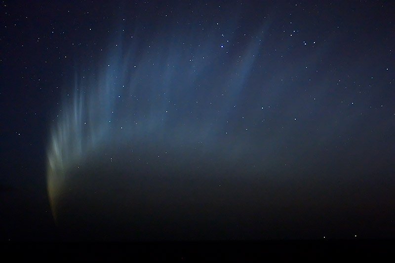
Here is a picture of the satellite status screen on one of my units during a spectacular aurora over NE Iowa. I was getting full signals from 10 out of 11 satellites on the screen!