


Iowa Tom
-
Posts
477 -
Joined
-
Last visited
Posts posted by Iowa Tom
-
-
-
Today I received notification of the “Latest Images from NASA's Earth Observatory, (03 July 2007).
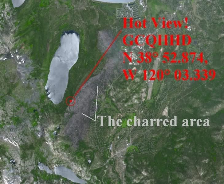
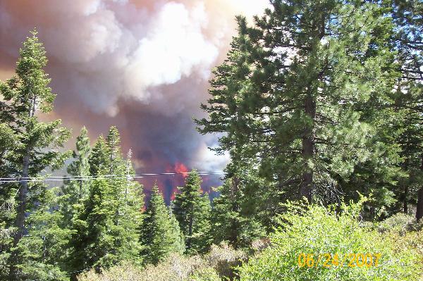
Amongst the satellite photos was one of the Angora Fire just south of Lake Tahoe. The burned off ash-covered area is clearly distinguishable in the image. Using Google Earth I figured out the coord of that spot and went to geocaching.com to see if I could find any cooked caches. I discovered one. It’s called; get this, Hot View!
 , a cache by the Tahoe Girls.
 About that geocache azdustdevil wrote this note on June 23, “I hope the cache location is still there as when we passed it the fire was very close as evident from the photo we took.”
From the look of this topo map, this geocache is just on the west side of a ridge where the fire didn't cross.
Check out the image of where the fire was and where the cache “is!”
-
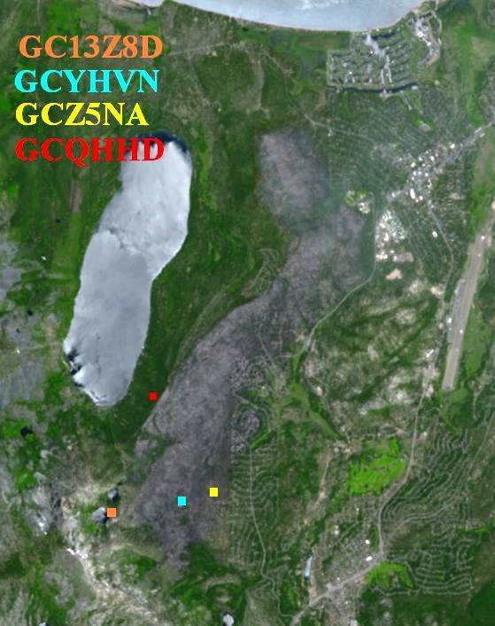
I was just contacted by geocacher ricknsarah who was in the area where this tornado occurred. He informed me that yet another geocache was in the swath of destruction. I added the other one to the satellite image pictured on the post I made on 7/2/07 here. They are both owned by TeamDouglas.
-
I see the increase in puzzles as an inevitable geovolution to a higher level of consciousness.
-
KEEP PUZZLES OUT OF GEOCACHING
I once told an electronic engineer about geocaching and he responded, "That sounds like a no-brainer to me." That was when I began to make geocaches that were definitely not no-brainers. I have developed a clientele of sorts. E.g. read this post. Once a prominent player of the sport told me that he passes mine on by. Why, he's like me and doesn't have the time to solve the hard ones. I make them because they are a challenge (some a big challenge) to create. I find that they are a way of expressing myself, of using my mind - also known as my brain.
Until creativity is banned from geocaching, I plan to keep on keep'n on.
-it
-
I experienced something like this when out counting meteors during a meteor shower back back in the 70s. I was setting up my lawn chair on a flat part of a quarry (at ground level) when I heard rustling. I'm not easily scarred but when I turned on my flashlight and saw at least a dozen glowing spots, I nearly had a cow! Actually that's what they were, black cows, in a picked cornfield. Since then I have dissected enough cow eyes and understand how they glow.
-it
-
Yep, by the looks of it, the cache I was wondering about is either in the open where it was or became a traveling cache!
 Look for the circle I placed to indicate where the cache is/was. Notice that the tornado seems to have veered S a bit, almost so the cache could get hit. The provider of the high res image added the lines, I suppose. That would prevent someone from using the image in its entirety w/o purchasing it. The URL that I obtained the image from is located here.
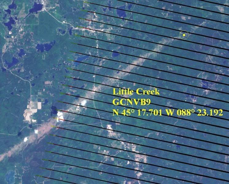
-
How do I delete waypoints out of my gps? I tryed up loading them to mapsource, and then deleting the way points, but when I download them back to the gps, they are all still there?
My garmin 60csx says waypoint memory full?
Page 12 at this http://www8.garmin.com/manuals/GPSMAP60CSx_OwnersManual.pdf site tells you how to do it. I believe that is the unit you have.
-
I have used geocaching.com as a resource to locate people living in areas of which I have an interest. This has educational implications. E.g. I once wrote to geocachers in New Orleans to arrange seeing a so-called iridium flare first by a student of mine and myself then by them over 800 miles away. They were a few minutes later (satellite time). We did see it and communicated by cell phone during the event. Thanks to geocaching.com, I was able to arrange it. They were trilled to participate. One person that did was not a geocacher but was a physics teacher that got wind of the upcoming event.
In another instance I wrote to a geocacher in Texas asking if she was seeing a wave of monarchs migrating through at that time. I obtained the migration information from Monarch Watch. She was more than happy to respond. Then again a person wrote the following to me about a my Monarch Watch geocache.
"Tom,
We are interested in the Monarch watch cache. Have you seen the Monarchs there yet this year?
Mick"
Quite recently a tornado recently ripped through Wisconsin. From this Internet source I obtained a satellite image of a tornado track. I wondered if it approached any geocaches. I thought it would be neat to try to get first hand information from a person who may have access to the tree damage. [One of my own caches (Tornado X-ing) is located where a tornado crossed a road not far from my place.] To see if any geocaches were along the track I roughly determined the coordinate of the track by comparing the satellite photo with Google Earth. I then used geocaching.com Google Maps to locate the area and after careful analysis I determined accurately where the tornado passed. Sure enough, some geocaches may have taken flight!
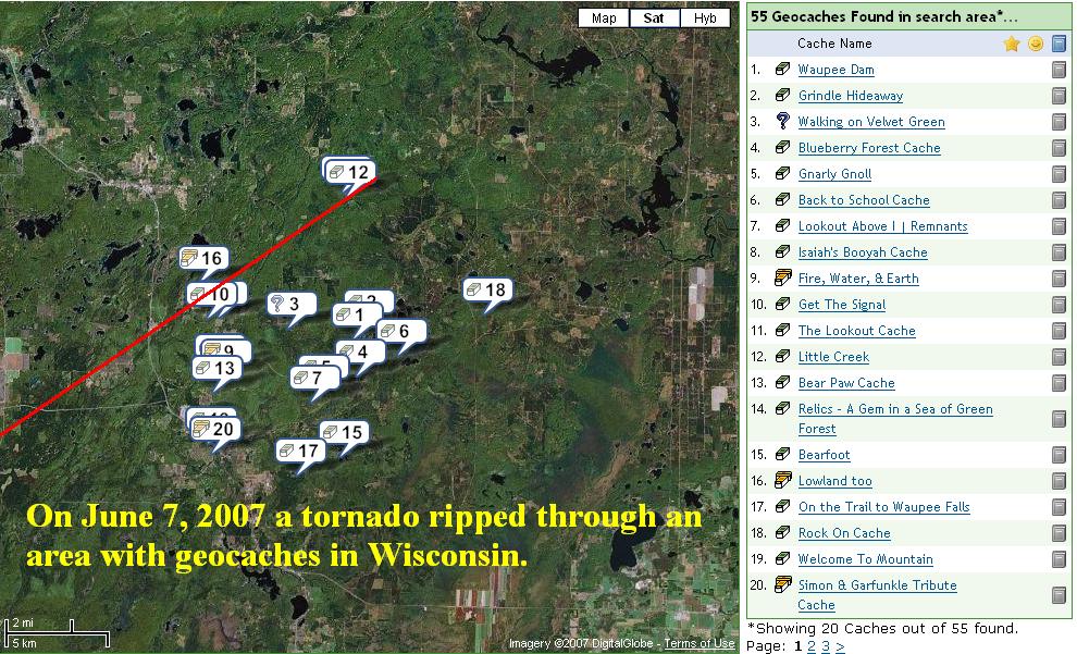
Below is the tornado track via the satellite. A large version of the tornado image is located here. This is where I got the info to start with.

Now what I want to know is where is the closest place to NE Iowa that I can go to hear the current emergence of the 17-year cicadas? I plan to start writing to geocachers about that too!
-it
PS My spell check thinks that the word geocachers should be one of the following: schoolteachers, dogcatchers, treacherous, encroacher's or poacher's.

-
I wish that I could know when a picture is uploaded in a log to one of my caches w/o having to to go to the log on the web whenever a new one shows up; or is there a way? Anyway what do you people think about pictures that show up with the finder holding the cache, so now people know exactly what they are looking for, and even worse, with the hiding spot showing in the background. I don't want to delete the guy's messages but sure wish I could delete the pictures.
I have just suggested to him that he is giving away too much information.
-it
-
I can't download from USA Photomaps either, and that uses Terraserver images. So it's them, not you. Hopefully it'll be fixed soon.
For a while I thought I was jinxed because about 30 seconds before I was going to hit the send button in another post about this problem, complaining about my bad luck, the power to a major part of my town went out. I confess, my bad luck cut the power to thousands of people.

-
I just made a cache that utilizes Terraserver Viewer yet when I now try to use it I don't get an image. My luck.
 I'm keeping my fingers crossed that this is a temporary problem. Does anyone know who runs it and does it currently work for anyone else?
-it
-
I have not read all the posts about this so I may be repeating what has already been said. About the human scent causing a parent to abandon the young; I once decided that that was probably something that was made up by a parent not wanting their kids to mess with an animal’s offspring. Many times I have proven that that statement is totally false. With rabbits and birds anyway, it has made virtually NO difference.
I do not believe that the scent of a human will overcome the instinct of a parent to take care of its young. I will agree however, that it is always best not to touch any animal however unless you have a good reason to.
I’ve read that the best defense of a fawn is to remain still because they have no scent. Apparently predators will walk right past them. This reminds me of the spiders in my house freezing when exposed to light because their usual predators respond best to movement. The one very young fawn I came across remained still even though several people were within touching distance of it. It was curled up on the ground.
-it
-
I find bones all the time and in fact made a cow skull into a really neat cache container. I called it Dummkopf. That's German for "block-head." I remember my grandfather using the term on more than one occasion, usually when I was riding in a car he was driving. The last guy to find my cow head cache said it was the best cache container he had ever seen. That was the last time anyone saw it. It headed off somewhere right after that.

-it
-
As far as I can tell it was the digital camera that was causing the problem. I have now mounted the camera about 15 inches away from the GPSr and see no signal degradation. I now use the telephoto setting to zoom in on the screen.
-
I wondered about that and did turn the camera on and off but wasn't able to come to a solid conclusion. I will try it again w/o the camera in place at all.
-
I have a Magellan Gold. It has a helix antennae. I just made a rig that enables me to photograph the screen the same way each time. I was experimenting with it tonight out in the wide open country here in NE Iowa. I noticed that when I first get a good signal that a lot of satellites have tall bars. Then before I know it they all go way down, then back up then down again. I also find that if I hold a metal plate over the top of the GPSr that the signal degrades a lot, like it should, but when I take the metal away the signals seem to spring back with a vengeance. I often get all tall bars again but then they waver like before.
I believe this happens across the whole sky with all the GPS sats. I do not think that it's caused by fluctuations in the ionosphere because the distance is far too great to be happening simultaneously and the speed of variance just too fast.
The only thing I can think of is my unit itself is causing the variation. Does anybody have any knowledge of why these rapid fluctuations occur?
-it
-
I would hide 15 Easter eggs, or something to that effect, that would each have a word in a sentence that they will need to combine into the original form. The sentence may actually tell them where a real cache with goodies in it is. The final cache could be a see who can find it first one. The sentence could be a puzzle as well.
Each student would be assigned a waypoint (egg) that they only will have permission to find. Everyone else will have to stand back and watch if it is not their turn. You could in fact label the waypoints with the kids names.
This method has its problems but would be better than what I did the first time through. When I let a group of kids go hog-wild the speedy Gonzaleses got all the finds and the slower kids found nothing. I will never let that happen again.
-it
-
I just tried using Google Earth to see the difference in longitude vs. latitude at my latitude (42˚ N) and up by Hudson Bay (60˚ N). I set three place marks at each location; two 1˚ of latitude apart while at the same longitude and one at the same latitude but separated by 1˚ longitude. There is definitely a difference, even at my latitude.
-
-
Every six feet is 0.001 minute
Technically, the distance for 0.001 minute longitude is not the same as 0.001 minute latitude. Longitude converges as we move from the equator but latitude does not. I don't know that I would worry about the difference though.
-
Are the external antennas only available for Garmins?
-
I feel that we gain accuracy by averaging values taken at different days.
That is true based on what I have read in articles that were quite detailed about the subject.
The error is compounded by the fact that the second person's unit is imperfect and conditions are different for them when they arrive. It’s error upon error so your initial reading is bound to be better than the next person’s. What I don't care for is the drop-n-click method used by some people that really don't know (or care) how to get a reasonably accurate coord of their cache when they leave it.
Until recently I didn't realize that professional systems also have trouble with tree cover as well. They too have to let their unit sit for quite some time to get super accurate data.
-it
-
I used to take a reading at the cache then walk off in a different direction 8 times, wait until my unit began to average, then move back to the cache and take a reading once it began to average. I finished by hand averaging all of those readings back home. That was quite a hassle and came to the conclusion that maybe just letting it sit and average once a second, or whatever it is, for 10 minutes, would do the same thing with a lot less work. I rarely get complaints about the accuracy of my readings done either way, and I own a lot of caches.
Likewise the visitor should get close to the right spot, wait for their unit to average for a minute, look to see which direction and how far to move, move there and wait a minute again if necessary.
I use Magellan and don’t remember if a Garmin averages automatically or not.
-it


puzzle caches
in General geocaching topics
Posted
Puzzle caches and other advanced modes of playing this game are a natural outcome of a maturing sport. The makers are using their minds more and requiring that the players do the same. That's great! "Stop and drop" singularities are being replaced by more sophisticated expressions of the minds of the makers. I designed and built the first stage of a two-part multi-cache as a bird-house that requires that the participant bring their own 9-V battery. Once they plug it in they have to figure out what to do to read a coord for the next stage. The first person to find it did it w/o any hint. Here's his log. I don't think he was disappointed. Bringing their own power supply gives the players more of a sense of participation and anticipation.
The one thing that does bother me about my own puzzle caches is that I have to go to great lengths to prevent cheating (AKA shortcuts). One of the first to visit my 9-V cache cheated so now everyone else has a harder time of reading the coord. I added a silvered piece of plastic to reflect the light of a flashlight right back into the cheaters eyes.
I'm looking forward to some [but not all] of the geocaches getting more and more sophisticated as the years go by.
-it