


Iowa Tom
-
Posts
477 -
Joined
-
Last visited
Posts posted by Iowa Tom
-
-
I just clicked on the name of my new category as listed on the page I mentioned above and I see this.
Present Directory Location:
Waymarking Games > XXXXXXXXXXXXXX <-- Name edited by me.
I'm going ahead with the peer review.
Thanks a bunch for everyone's help!
Tom
-
Last night I went to bed at 2 AM after taking the time at creating a category for the games group (or whatever it' called.) I went through the steps beginning at the Waymarking games site. Now I am ready for the peer review but it looks like the category is listed under the denied group (Space Science) that I tried to start last week.
I do not see the games group mentioned anywhere on the page where I see the following:
________________________________
Space Science
[change logo] founder: Iowa Tom
date created: 8/22/2006
no. of members: 3
description/mission statement:
XXXXXXXXXXXXXXXXXX <-- Description of the Space Science group edited out by yours truly.
open enrollment: OFF
Category Status: XXXXXXXXXXXXXXXXXX <-- Name edited out by yours truly….category has successfully been reviewed by the group's officers.
Congratulations, your group has fulfilled the prerequisites for managing a category. To begin the category creation process, follow the steps below:
1. Create/Edit Your Category (this is checked)
2. Add Category Variables (recommended) (no check – I didn’t do this)
3. Call for Officer Vote on Category (this is checked + there's an X)
4. Call for Peer Review on Category (I’m afraid to click here till I know which group this is going into; or is the group even a consideration at this stage??)
-
At this site there are listed Waymarking Games. I see that they are listed as subcategories. Can someone help me to know how to submit a new game for approval? It looks like I can start a new category but not a new subcategory.
Thanks!
Tom
-
As of last night I tried to make a group in Waymarking under the “Nature” category. It’s my first so I may not have done everything correctly. It was not an intuitive process for me.
 It’s called Space Science. I would like to see it used in part for “locationless waymarks” because that’s the only thing that will work for certain educational activities I have in mind.
 This thread should really be in the Recruitment and Category Proposals forum.
You are absolutely correct! Oops.
-
I have a waymark that I would like to make into an Earthcache but have been told that now an Earthcache is actually a waymark. Huh? If that's the case then why is it that here the Earthcaches show this earth icon?

How can I make my waymark into an
or make a copy of it so that it’s categorized as an ??? -
part 1 - Would it also include something like the home or hometown of a famous Rocket Engineer, or an astronaut?
I suppose it could. I discovered on the Net where all the launching facilities around the world are.
Part 2 - Would a $50.00 digital camera get a good enough picture of the Pleiades meteor shower? Many of these streaks seem to be quite dim to the eye.
I don't know what the cheap cameras are capable of but I could take a guess if I knew the name. One of the challenges would be to find out what it can do. If that isn't enough for the task then I suppose the person would have to get creative and ask someone else with a descent camera for help. A teacher may have access to local area education agency digital cameras that can take exposures that are at least several seconds long. When I was 12 I crawled up on the roof at night and set up my mom’s old box camera in an attempt to photograph star streaks.
Take 100 shots and hope one has a bright streak? Brrr, I'd freeze.
Of course there's always the Perseid Shower in August. But it's over. Now I wait for a year.
The meteor shower is an advanced challenge for anyone. It could be an advanced waymark. But challenge is the name of the game. Besides that, not getting a picture could be a learning experience in itself. I’ve been there and done that. E.g., I’ve discovered that I can bring things into view using a photo enhancing program that I didn't even know was in the picture.
Thanks for the input.
-
As of last night I tried to make a group in Waymarking under the “Nature” category. It’s my first so I may not have done everything correctly. It was not an intuitive process for me.
 It’s called Space Science. I would like to see it used in part for “locationless waymarks” because that’s the only thing that will work for certain educational activities I have in mind.
 Concerning the locationless concept and Waymarking, I read the following here:
Locationless caches could be considered the opposite of a traditional cache. Instead of finding a hidden container, you are given a task to locate a specific object and log its coordinates. A scavenger hunt of sorts, it involves collecting waypoints of various objects around the world.
Locationless caches have evolved into Waymarking. Waymark categories are similar to how locationless caches were listed on geocaching.com, but you can now search for the locations in each category.
However, what I seem to be reading in the Waymarking forums is the idea that locationless “caches” are not so desirable to many people.
My motivation for making the Space Science group was to do several things, two of which I mention here. (1) To encourage people to find and tell others where launch sites and various space agency facilities are and so on. That requires a definite coordinate. But what is more (2) I would like to see people get involved in trying to document transitory phenomena. The whole act of trying to capture an illusive object in the sky for instance, whether it is an aurora or a meteor or a passing satellite on film or pixels introduces a challenge that lends itself to an increase in knowledge and skill for everyone that even so much as attempts it. Waymarking should be not just for fun but for fun education.
As an example, I first purchased a GPSr to place myself on the centerline of where the International Space Station (ISS) could be seen to transit the center of the sun (and later the moon). The reason I jumped on the chance was because Don Pettit, who was in orbit at the time, agreed to try to see if he could spot a reflection of sunlight off a large mirror I had below. It was only after that, that I learned to use my GPSr for geocaching. Getting to the right place and pointing a camera at the right spot then knowing enough about a camera to get the shot requires a lot from a person; it encourages one to think in ways that result in self improvement.
Of course the location of the spot where I last photographed a lunar transit by the ISS is not important to anyone outside the satellite observing community I belong to but still, the fact that I accomplished the task and recorded valid scientific data made me a more educated and technologically experienced person, something that Waymarking should encourage.
Some will say that simply catching the ISS passing anywhere through the sky would not require a coordinate to pinpoint the spot where it was documented but coordinates are a part of the scientific data used in describing that type of activity! So no, it may not attract others to a certain site because a coordinate was listed for a locationless cache but why is that always necessary? Isn’t the act of getting credit by doing something challenging and education sometimes enough? Ask the person who actually got credit for what they did and are proud of. I often look to see how far north a person is who documented a flyby of the station because, few know this, the ISS is never more than a handful of degrees above the horizon as far north as Alaska. I see Waymarking using certain locationless caches to encourage people to try an experiment with such activities as capturing a satellite pass as a potential benefit not only for them but for how this actvity looks to outsiders. How many educators would be against it??
I hope that people will be willing to help my officers and me to make a Space Science group work, with some locationless categories. I would use it in my classroom for sure. How many science teachers wouldn’t? (!) Please vote yea here if you are willing to help or at least encourage us in getting this off the ground. Please make Waymarking more multifaceted to better meet the educational community. Thank you!
I need to go, school starts tomorrow!
Tom, high school science teacher, NE Iowa
-
I currently have a mount that I have in the woods that allows me to get repetitive pictures, in 3D even. It's not hard to set up and the results look like they are going to interesting after 1 year. The same thing could be applied to your situation.
-
O feet. I used my place as a false coord for a mystery cache. The first part of the sequence of caches it refers to is about 1 mile away.
-
A friend of mine with the last name of Friend responded to my telling him about geocaching, "That sounds like a no brainer." He wasn’t interested. Oh well. That was an impetus to begin making caches that DO require brainwork!
I have many times been told that “I have too much time on my hands" or that “I'm easily entertained.”
Those responses seem to come from those people who haven’t a creative neuron in their cranium and complain about anyone that is successful in whatever they do as being an "overachiever."
I teach five subjects in science every day so no, I don’t have a lot of time on my hands. I do however trade time on the couch for time in my garage building another cache or working out the details of another puzzler and so on. I consider it a blessing when I find ways to be easily entertained by what other people either overlook or step on.
-
I use an old Palm Vx I got cheaply on eBay. Works great. You don't need much of a device for paperless caching. a Palm III will do you fine. I like using a CHEAP device because I've broken 2 of them in the field so far. Even a hard case doesn't help if you stick the thing in your back pocket and then sit 245 pounds of cacher down on top of a bumpy rock. The loud CRACK sound is a dead giveaway that you have forgotten about your Palm...............

Maybe you should refer to that one as your gluteal pilot rather than your palm pilot.

-
I saw that there were some caches in Greenland that I suspect shouldn't be there because of maintenance problems.
About the virtual cache at the South Pole itself, I told a friend (Dana) about it who worked there for three years. He had the chance before he left to claim it but must not have been interested. He was an engineer at the Amundsen-Scott South Pole Station for 3 years straight but is temporarily off the ice right now. He had a lot of fascinating stories to tell! No spit does not freeze before it hits the ice, even at -100 F.
He wrote to me last year after Googling a post I made to a satellite group years before. I had brought up the fact that so called iridium flares can occur there with extreme frequency at times and he was seeing them one after the other, like every 5 minutes! I made this cache to tell the story about what he saw there and to encourage others to look for them as well.
If interested Dana’s webpage is here. I wish I were going along!!!!
-
Just received my first unit, eTrex Vista cx, and then flew to Argentina. Only get two satellites in Cordoba. Is there a way to check avilable reception in a geo area or do I possibilly have a weak receiver? Also, the base map is really a disappointment. Guess that all I get for $300+. wink
Here is a list of the GPS satellites and their positions over Córdoba, Argentina at one point this afternoon. I obtained the data from CalSky. There is no place on the surface of the Earth where you can escape the signal of GPS satellites.
Observer Site Córdoba, Argentina
WGS84: Lon: -64d10m12.0s Lat: -31d19m48.0s Alt: 472m
All times in ART
PRN 20/GPS BIIR-
(26360 2000-025-A) Mag=11.0m Sagittarii
az: 110.7d ESE h: 62.1d dist: 20809.0km
ra: 19:42.6 de: -36:55
PRN 23/GPS BIIR-
(28361 2004-023-A) Mag=11.2m Pavonis
az: 175.5d S h: 61.7d dist: 20836.8km
ra: 17:46.7 de: -59:31
PRN 13/GPS BIIR-
(24876 1997-035-A) Mag=11.8m Centauri
az: 250.8d WSW h: 54.4d dist: 21194.8km
ra: 14:39.0 de: -35:54
PRN 24/GPS BIIA-
(21552 1991-047-A) Mag=11.9m Centauri
az: 242.0d WSW h: 49.8d dist: 21132.7km
ra: 14:13.8 de: -41:02
PRN 04/GPS BIIA-
(22877 1993-068-A) Mag=12.3m Centauri
az: 228.3d SW h: 29.0d dist: 22861.3km
ra: 12:08.3 de: -48:32
PRN 11/GPS BIIR-
(25933 1999-055-A) Mag=11.5m Herculis
az: 7.8d N h: 24.3d dist: 23135.1km
ra: 18:04.0 de: +33:55
PRN 27/GPS BIIA-
(22108 1992-058-A) Mag=12.0m Coronae Borealis
az: 336.0d NNW h: 23.2d dist: 23414.5km
ra: 15:46.3 de: +30:49
PRN 16/GPS BIIR-
(27663 2003-005-A) Mag=11.2m Aquarii
az: 93.3d E h: 12.4d dist: 24507.7km
ra: 22:53.9 de: -9:09
PRN 25/GPS BIIA-
(21890 1992-009-A) Mag=11.4m Phoenicis
az: 140.3d SE h: 10.3d dist: 24348.6km
ra: 0:53.7 de: -47:44
-
I have taught two geocache classes so far plus I’ve made two caches for my regular students. Both of the official classes were for middle school age kids in a summer enrichment program. The one thing that I found most time consuming and frustrating was getting everyone registered during class time. Maybe it’s just because they were young, but I can say that they are more computer/Internet savvy than a lot of adults, or as my daughter used to say when she was very young, dolts.

Setting up an account at school requires Internet access of one’s own e-mail. A lot of people don’t know how to do that. The other thing is, expect problems with registration. It happens. I have been tempted to require a geocaching account as a prerequisite for taking my class! That would solve a lot of hassle right off the bat. Since they are taking it for credit you might offer them extra credit (or at least a donut) for being registered ahead of time. They could e-mail you the proof before the first day.
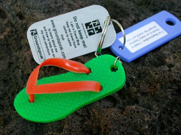
I really like to start them out with travel bugs. That is a great way to remind them over and over again that geocaching is alive and well. I send home a set of instructions the first day telling them what to bring in as a possible bug item along with an idea for a name and a goal. In class we register the bugs (this is another opportunity for frustration as problems do arise – so be prepared).
This is a bug with a goal tag that one of my students set up. I provide the tag and use a table cell to make sure the goal will fit the space allowed. Laser ink does not run when wet but non-laser printer ink probably will so spray the water soluble ink after printing with a matt spray. You need to order the tags in advance, obviously.
Every time I teach a class I have made a special cache just for the participants. We placed all the TBs in it. The class also got to paint it. I use flat camouflage colors and lay leaves over it as I spray over them. The ghost image of the leaves adds a good amount of camouflage to the cache. The caches I made for them so far are unique. They are made of 4” waterproof plugged PVC pipes. The paint does not stick well to that so I first wrap the PVC with camouflaged duct tape. If the paint comes off there is the tape below. The tape does fade to cyan with time however. I have them do a sloppy job of wrapping the tape onto the tube to add texture. Do make sure it’s stuck down before setting it out. Don’t want water to get under the tape.
One thing I did for the kids was I hid a number of Easter eggs. Each egg had a word in it. Once they located all the eggs they had to assemble the words into a meaningful statement. The sentence was, “Thank you for being such good students!”
I made this puzzle cache for them to figure out. They really took to that!
Having ready to go, a bunch of good cache websites to study is a great asset. That will teach them a lot.
I have explicit instructions about how to register on geocaching.com and how to register a TB in Word format with screen captures if you are interested. In the TB section I also explain how to track a TB and so on. I could give you the details for the table cell that perfectly fits the key identifier tag I use for goals if you want.
Good luck!
-
If you register with CalSky you can select Satellites then GPS and get a lot of current information about what's over your location right at the moment.
When you get to the first GPS page:
*check the box beside, "Show list of GPS satellites at the selected moment of time, rather than the GPS quality chart,"
*then under "Select start of calculation"
*click on "Now."
*Then click on the "go!" button
You will see all kinds of data about the GPS satellites that are in your sky right at the moment, including their magnitude. It's fun to see the data match what's on your GPSr screen at that time.
-
I will be up in the Minneapolis Minnesota area the first week of October to enjoy the Fall Folage and was wondering for those of you who Geo in that area, are then any caches that are a must do, that you all could reccomend to me. The cities or an hour out would be fine. I notice there are many caches, but thought maybe you all had some favorites that you would share. Thanks for your time.
Fishercz20
Are you flying in?
-
Caches like this can be fun, but if you're thinking of locking a cache to thwart cache theft, think again. I believe a locked cache will increase the chance of a cache being stolen.
Think about it. If someone is walking along and finds a box hidden in the woods, it might pique his interest and he will open it to see what's inside. If he sees the logbook and reads the geoletter he may put it back, his curiosity satisfied. But if someone finds a locked box hidden in the woods, he is more likely to bring it home and take a sledghammer or hacksaw to it to see what is inside.
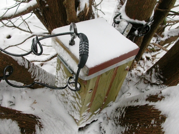
I always think about what a muggle might do to take something that is not theirs. This one was quite a challenge to make more foolproof. By using a lock with a hidden key and some rusted parts that look like they are supposed to be there, the muggles have not yet taken it after a year.
I once read that thieves are notorious for being lazy, hence the reason I tend to make multi, mystery and puzzler caches. I hardly have any in the city but my “VAULT” is. I knew that it wouldn’t be long before a neighborhood muggle would find it so, rather than just leaving it open for the taking of my student’s TBs I gave the muggles a challenge. The box is reinforced in multiple ways and is not just locked, it’s also strung to a tree with a thick cable and a large lock. The hiding place is an arborvitae tree that is perfectly suited for the cache.
They would have earned it I suspect if they got it off the tree and get it open.
There is another way to get the combination. It's the year that the next total solar eclipse is crossing through the Midwest.

Here's a picture of the VAULT in situ and here's its webpage.
-
Neat idea!
Maybe you could simplify your work by drilling a specific sized hole (that wooden dowels are the size of) in each disk then when they get to the final cache they would slip each disk onto an appropriate sized dowel sticking out of a block of wood. Let the figure out what to do. Don't tell them anything other than they need to take a disk with them.
-
I just read a post that included information about how to get the combination to a combination lock associated with a cache. The idea was to have the combination match the cache name. I assume a phone key pad is used for converting letters to numbers. That sounds like a good idea to me.
Last year I made a cache vault that is locked. I didn’t want to list the 4-digit combination online. I also made it so a GPSr needs to be used on site to get the combination. To obtain the numbers the geocacher needs to make a GOTO to two distant coords. I found that different units produce different numbers of miles when far off so to prevent any possibility of subtle differences between GPSrs I made it so that only the first part of each of the distances is part of the combination. Both GOTOs use the same longitude of the cache.
I posted a laminated instruction sheet on top of the cache that reads something like this:
The combination equals the first 2 digits of the miles from here straight north to a latitude of 72˚ 11.111'N followed by the first 2 digits of the miles from here straight north to a latitude of 67˚ 44.444'N.
How do you "hide" the combination to your locks?
-
There's that kid that was on StarTrek. Will ????? I need a treky to help me out. He's not a kid anymore. Married & has a couple of kids himself. I think he used to cache with his brother.
I remember reading it about 3-4 yrs ago. He mentions it on his blog. Can't remember his profile either.
Also, this he does something with computers now. Remember seeing him on that geek channel.
A lot of help I am, huh?
Wow, I was just wondering about him recently. I wondered where he ended up.
-
I accidentally broke a bottle containing about a half a liter of fuming nitric acid on the floor of my classroom one Saturday a few years back. I was on the evening news, albeit hiding as well as I could in the background.
Seven vehicles and 17 people showed up to take care of the hazardous spill.
Would that qualify me as being somebody?
-
I have been using Test Drive Eagle at Geocode.com.
-
I know how you feel when getting some complaints. Seems like whenever I start a new activity I begin by being overly sensitive to what people say and I read between the lines when there's really nothing else to see.
I myself have a cache in the location where a Northern Hawk Owl spent much of its time back in the mid 80s. Up until last year that was the only time that that species of bird had ever been recorded to have ventured as south as Iowa, or at least into Iowa. I spent many hours observing and taking notes about his "daylight" behaviors - they hunt during the day and sleep at night. To make a record of his roost I set up a cache there a couple years ago. The owl must not have had good taste since the woods are a major CITO area. I don't have the time to clean it out myself and no one else seems to care to help. Where the owl was it was. I used to get complaints about the trash until I wrote a warning on the webpage about that location not being for the "trash-o-phobic." I explained the historical significance of the area and leave it at that and no longer pay much attention to words about how messy the place is.
-
I have wondered that myself. I often look at profiles for fun.
I often don't get a reply if I say hi. That seems to be the nature of the email society though. I myself have occasionally not responded to mail I got from a friend.
Then I feel badly about forever.
 It’s called Space Science. I would like to see it used in part for “locationless waymarks” because that’s the only thing that will work for certain educational activities I have in mind.
  It’s called Space Science. I would like to see it used in part for “locationless waymarks” because that’s the only thing that will work for certain educational activities I have in mind.
Waymarking Games
in Waymarking Archives (Read-Only)
Posted
I sure wish I could edit the HTML of the category I am about to submit. There are some little things that I did not catch. Does anyone know if my HTML in what is being submitted by me can be edited yet?