


Deadelm
-
Posts
98 -
Joined
-
Last visited
Posts posted by Deadelm
-
-
I just noticed that New York and Long Island is available here now: http://www.maps4me.net/usa/2/ Great free topo vector maps with streets and poi's. There is a small one time registration fee (-$10) for large map files.
You can view the NG Topo map for your area here: http://www.topo.com/explore
This program is very simple to make your own street maps with OSM image downloads: http://www.tritonforum.com/forum/viewtopic...f=32&t=2933
-
I guess I’m just tired of looking at mostly blank screens except for the cache. Even my blackberry can show me the caches over google maps (Cacheberry)
Your Triton can do the same. You need to make some custom satellite image maps for your area. http://www.tritonforum.com/Files/Create_Cu...on_RMP_Maps.pdf
-
Are you a member here yet? www.tritonforum.com
(never mind, I see that you are)
You could make some of your own maps described in this section: http://www.tritonforum.com/forum/viewforum.php?f=32
-
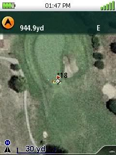
The Triton gives yardage. I have five local courses mapped and prefer placing the waypoints at the front of the green. It has been a big help for club selection since I'm an occasional golfer.
-
That is, the actual point on the face of the earth is 380 meters away, on a heading of 86.26 degrees (almost due West) from the point you select on the satellite image.
This is not especially good, even for someone who plays as poorly as I do.

...ken...
I'm confused........do you meen plotting the waypoints or your golf shot

-
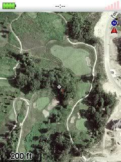
Triton 400 on up can do both with the help of custom image maps of any golf course on the earth that is covered with good imagery from google earth or msn (bing). Or as Ken pointed out, just create and load the waypoints on any good gps and you will have your yardage help. These points could easily be created using google earth, then converted to load into whatever unit. The image that TotemLake provided is a good example of what you would get with your own custom maps for the Triton. I don't know the coverage of imagery that the Delorme could provide. I have checked out a few of the golf course map sites and they seem to be limited to select areas and popular courses only.
-
New features and improvements for Magellan Triton 200-500 and 1500/2000. Here's a helpful link: http://www.tritonforum.com/forum/viewtopic...?f=1&t=3018
-
The bugs have been worked out. But the 200 or 300 is not a good choice because they lack the sd card expansion. It would need to be a Triton 400 or higher.
-
Do you have the latest firmware installed on the 1500? It has cleared up most of the lock up problems with VP.
-
It's needed to keep your head above water.

-
OK, that worked, but I have several hundred caches...I guess the only way is to do that one by one? Ugh. Thanks for the help!
Or get the premium membership here to use the gpx files.
-
It's actually the "Placed by" box in the details edit screen in Vantage Point. Put something in there if it is blank.
-
The hider field is blank with a LOC file. Edit this in Vantage Point by adding a name or just a letter. Then export to the Triton. This took care of the LOC file problem on mine.
-
Use the up arrow then center select key when using the coordinate editor menu. This will allow you to select the coordinate system to use for entering. You may also want to set the gps coordinate system to your desired Lat/Long accuracy by going to menu>view>settings>navigation. This is with the latest firmware version 1.72.
The backlight eats up batteries. Set the backlight timer or turn off the backlight as needed.
-
Make sure the display setting for distance is set to Miles/Feet, or just Feet. Menu>view>profiles>display(page).
-
fat bubz, you will still need to use vantage point to get the geocaches on the Triton (unless you enter them manually
 ) SkellyCA has posted a "how to" about this several times in these forums. You can also find info on the tritonforums.
 -
You do not get the Nat Geo Topo maps to the Triton with Vantage Point. Use NG's compatible versions. TOPO Explorer version 1.2.1, TOPO version 4.4.3 or 4.5. No sd card on the 300, so the map size to export will be limited.
-
The upgrade did put data fields on the main screen but didn't address any other issues. The Triton is now horribly out-dated and fatally flawed.
The update took care of several issues. I notice from this forum that Garmin and Delorme have their share of problems too. All electronic gadgets have bugs and things that don't work as you would like them to. It comes down to what you can accept and personal preference/opinion. I have no problems with my Tritons, just a few minor features I would like to see added.
-
I love my Triton 400. But for some reason they get bashed and I haven't figured out why. It works great for me.
-
It doesn't look like they're going to let the Triton sink after all.
-
Be sure the container is well hidden or I might spot it on my Triton
-
Give up on the TOPO Explorer for now.
The 400 is a great gps. Make your own maps. Nothing compares to the detail and clarity of a custom hybrid map viewing at 100' zoom.


 ) SkellyCA has posted a "how to" about this several times in these forums. You can also find info on the tritonforums.
Attention: Magellan 300-500 Series Users - Help Needed!
in GPS technology and devices
Posted
The 200 and 300 have limited map storage memory because they lack the SD card expansion. I have a 400 and 2000 that work great. I really like the ability to load raster image maps. They all receive WAAS.