

Deadelm
-
Posts
98 -
Joined
-
Last visited
Posts posted by Deadelm
-
-
You can select and delete all in Vantage Point, and the same on the 400.
Did you post this question on tritonforum? If so we missed it.
Morel
-
The SD card is memory expansion only for maps and media. The 400 is limited to 1000 waypoints, 1000 geocaches, 20 routes, 15 tracks, and only on the internal memory for user content of 20 MB total. What is eating up the memory on the unit? Do you have other maps loaded there?
Use Vantage Point to back up the internal memory, clear it all out and then reload only the geocaches, point, routes, tracks needed. Keep all maps on the SD card except the original base map.
-
Here are the directions from Geocaching.com: Field Notes select the "Magellan tab"
-
This mod is working great with the maps4me US base map and US central detail map along with the POI file. Got a couple of my custom rmp maps on as well.
221 MB US base map
1.05 GB US Central detail map with 11 MB POI map overlay
58 MB image map
-
The quick and easy way to get the PQ on the Explorist:
1) attach it to the PC with the USB cable
2) power it on
3) select "connect to pc"
4) should be recognized and open the drive to view files, or browse for the drive and open it
5) open the "Geocaches" folder
6) unzip the PQ file and drag it to this folder (to unzip, right click and "extract all")
7) you can place the additional waypoints within the PQ into the "Waypoints" folder if you want them (not necessary)
8) a good practice to disconnect is to use the "safely remove hardware" icon in the lower right task bar of the PC (right click)
-
Does it show any sign of trying to power on? Like the start up screen that shows Magellan Triton and the progress bar.
-
It is really not usable anymore. You can use the State Series if you have it. Log in and purchasing superquads has been discontinued. You can use the free program Vantage Point from Magellan and use the yearly subscription with an account through Magellan to create maps from NG Topo.
-
system security blocking? be sure to allow the program to "always allow"
-
I updated my software from magellan website today and gc will not load my gpx files now. I'm so mad. Was planning a geo trip this weekend now I'm screwed. Has this happened to anyone else?
Just connect the GC and drop the files into the "Geocache" folder on the unit.
-
Open the bottom left on the four corners. Select tracks, then bottom right (options), clear active track or hide active track or delete all.
-
Page 8 from the manual here: http://support.magellangps.com/support/assets/manuals/112-0012-001_A.pdf
-
Try the reset next to the usb port. But it sounds like a defective unit that needs to be returned for a new one.
-
There are several map options that will work in the Triton. The problem is the 300 has limited available memory (20 MB) to add maps. You will need to use a program such as Mapsend topo 3D, or NG Topo to be able to cut a map area you need within the file size limit. There are ways to create your own custom image maps, but again the 300 does not have expandable memory so the map cut area will be small.
-
There is a reset button under the USB cover.
-
Connect the GC to the computer, select "connect to pc" on the unit, don't do anything else with the GC once it is connected. Open the drive letter assigned to the connection (G is what you told us), there should be some files and folders on that drive (it's the internal files of the GC), open up the "Geocaches" folder and drag and drop, or copy and paste your downloaded .gpx geocache files in that folder. Now close the drive, "safely remove hardware" icon in the start bar on the lower left of your computer screen. Unplug the GC and it will startup as normal.
-
What browser are you using? Internet Explorer, Google Chrome, etc....
You can also create a gpx PQ and drag it into the geocache folder on the GC or download individual gpx files and do the same.
-
works fine with the 400. Two Triton 400's, a 2000, two GC's, EX710, three different pc's and OS's. All the way from VP version 1.21 through v 2.04
-
There are several ways. From the Geocache screen, go to menu, add geocache. It will average your position. You can also do the same thing from the waypoint screen. View your position by viewing the coordinate fields from the dashboard or map screen.
-
There is a reset button by the usb port. You can also try Menu>Up>Power buttons while connected to the pc and reload the software.
-
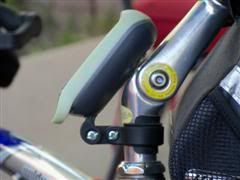
Not precise, but these are the dimensions I have that fit the slot:
- 30mm slot length
- 15mm x 2mm at the base
- 10mm x 1mm at the tip
It will not slip out unless you have it mounted upside down

- 30mm slot length
-
Nice rigging there in the pics, I'm interested to know has your gps ever vibrated out or gotten loose after biking on less-than-smooth terrain? I like the idea, I may have to try it.
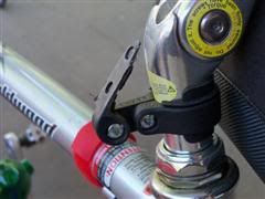
It is very secure at that angle. Take your time with the filing and fit. The GC slot is double tapered and gets tighter as you push it in place.
-
The OP is asking about the Explorist "GC". They have not come out with one yet so I made my own with a file and a reflector mount. Works great!
-
They will need to go on the internal memory, and can only be transferred with the Vantage Point program from Magellan.
-
You've been reading posts all over the place but missed reading the user manual here: http://www.magellangps.com/assets/manuals/..._UserManual.pdf
There are selectable fields on different screens. You can have a "distance to end" field on the compass screen that will show you the distance down to "0" ft. I use this same field from the map screen.
This product is not inferior, just not the same as the other one, just as that one is not the same as the other one and so on.....

Magellan Triton SD card issues
in GPS technology and devices
Posted
Go to the list and scroll down to highlight one. Press the menu button to bring up the options, scroll down to delete all.
To clear all user data, go to: view, settings, memory, clear memory.