

The Forester
-
Posts
1433 -
Joined
-
Last visited
Posts posted by The Forester
-
-


Well said; and well timed.
I'm delighted to see people recognising that Crimbo starts on the 24th of December, not, as the commercial money-grubbers wish, somewhere around half-past September!
Happy and merry Christmas, everybody (and Eid Mubarak to many others!!)
-
Rutson and Don K deserve a semi-ding each.
The innovator of what we now call GPS was Roger Easton, who, like John Harrison a couple of centuries earlier, had the insight to realise that the fundamental secret to real-time 3-D navigation is time.
Also like Harrison, he was a better engineer than he was a marketing wonk, so his vowel concatenation of TIMenavigATION into Timation was somewhat clumsy. Like Harrison, however, he knew that to implement his idea he would have to go to the deepest pockets to find funding. In 1964 the USAF had a much greater budget for that sort of thing than the USN, so that's where he went for the R&D budget. To this day the USAF is the 'owner' agency of NavStar/GPS.
Timation was devised quite independently of the Doppler-based Transit system and was also separate from the USN follow-through of Transit which lacked the third dimension. The Navy really didn't care about or need 3-D fixes as even their submarines knew their height above or below sea level. Their putative version of Easton's Timation was cruddy and inherently limited, not merely by its budget.
Easton's Timation really was the mathematical model and prototype of what we, perhaps wrongly, call GPS.
Rutson's answer was first, but slightly off the bull's-eye, so he deserves a hemi-demi-semi-ding.
Don K's answer was timatiously second, but was spatially slightly closer to the cache, so his is a demi-hemi-semi-ding.
In the spirit of Christmas Present, not past, I leave it to either to be the first to claim to the full ding and to set the next Q.
Cheers, and Happy Crimbo to all,
The Forester
-
Time for a clue:
The original system name was based on the navigation system's operating principle.
-
The satellite navigation systm which we know generically as "GPS" is actually called NavStar. Its forerunner was a Doppler-based system called Transit.
What was the original name given to what is now called NavStar/GPS when the early development work on the operating principle was commenced?
-
I've tried using one of these wee things this year in a couple of dusty spots East of Suez (30°N and 32°N, respectively). It has a couple of drastic flaws in its concept.
First flaw is that it's (in the words of the BBC tv announcer) "Not for viewers in Scotland". The teenyweeny solar panels need plenty of bright and warm sunshine -- and that's not something which is found in abundance at 56°N. Charging the battery up from flat would take more hours of daylight than we have in a winter's day.
A much more serious flaw is that its own battery is just too wee. A 4pack of good AA-sized NiMhs stores 4 x 2.8mAh. That's 11.3 Amp hours. This gizmo can only hold 1 Amp Hour, so it's a bit like trying to fill the petrol tank of a car slowly, with a beer glass.
I indented for the thing as I needed complete assurance of power supply for several SatPhones, such as Thuraya and Iridium, as well as several grown-up GPS units. I think I wasted the taxpayers' money. I gave it away to one of my minders who wanted it to power his iPod.
Some Chinese technicians on the Kajaki project, who were working to repair some of the damage inflicted by the Neanderthal bombing in '01, had a vastly more practical solution. They had rollable solar panels, which were tailored to the inside shape of the windscreen of their 4x4 vehicles. Whenever they parked their vehicles, they always pointed them approximately South and unrolled the panels, which charged the vehicle battery and had outlets for charging every imaginable type of electrical gizmo. That was a much more practical way of charging batteries, and prolly cost an awfy lot less than this silly wee tool.
-
I was adversely surprised that the GC.com reps had failed to take appropriate action, despite them being aware of the locations of all the zones.
-
Right from the beginning, as far back as last Thursday when the government was first formally informed of the outbreak, it has been something of an open secret in the beef farming community that the two prime suspects for the origin of the disease's spread were the government's own lab at Pirbright and the government's own supplier of FMD vaccine, also at Pirbright. On Friday morning, when the government formally issued the 1km zone around the site of the first publically admitted infection site, I was asked to use my GIS to measure the distance of the spread and to examine the wind velocity records from the third week of July onwards. Today is the fourth day in which the Pirbright plume is the prime suspect as the originating vector of the current outbreak.
Yesterday's increase of the area of the two zones came as no surprise to anybody, I think. What surprised me this evening was the fact that there were still any caches within the openly published Protection Zone which have not been temporarily suspended. In view of the fact that there is usually a timelag between people reading a cachepage and actually going into the field to hunt that cache, and in view of the very prompt actions which have been taken by the government and by the rural community, it was regrettable that all caches within the inner zone had not been temporarily suspended. FMD is an extremely infectious disease and it is surely well known that the disease can so easily be transferred from one location to another on the feet of people and dogs and on people's clothes and cars and on the fur of dogs.
Although the countryside is open, on the British mainland at least, surely a bit of commonsense should be used within the control zones when considering whether to encourage walkers to venture into the countryside within a 3km Protection Zone? Surely very special consideration, on a case by case basis, should be given to each cache whose location or potential approach or egress routes are closely adjacent to the inner 3km Protection Zone(s) and are located within the 10km Surveillance Zone(s)?
Here's a sketchmap of the zones which were promulgated yesterday and early this afternoon
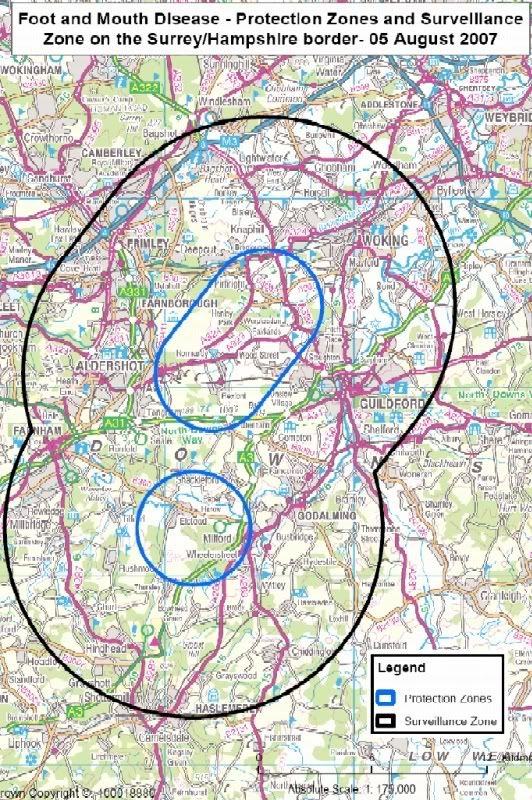
The coordinates of the main centres of the zones are:
51° 14.880N 0° 40.572W
and
51° 16.788N 0° 38.100W
and
51° 10.469N 0° 41.537W
The lozenge shape of the zones does not readily lend itself to the GC.com cache database search system, so some paperless cachers may perhaps want to electronically plot the shape on digimaps such as MemoryMap. If so, the straightline sides of the 3km zone run from:
51° 15.901N 0° 42.574W to 51° 17.809N 0° 40.103W
and
51° 13.624N 0° 42.197W to 51° 15.532N 0° 39.728W
-
Well done, Lacto.
One of many lessons learned from the 2001 fiasco, which was a genuine disaster for the rural community of huge swathes of Britain, was that inaction in the earliest stages of such an outbreak leads directly to the exponential spread of this extremely virulent disease. The gumment seems to have reacted swiftly and decisively this time.
I'm glad to see that GC.com has taken decisive action within the 3km Protection Zone and is carefully considering the options within the 10km Surveillance Zone.
-
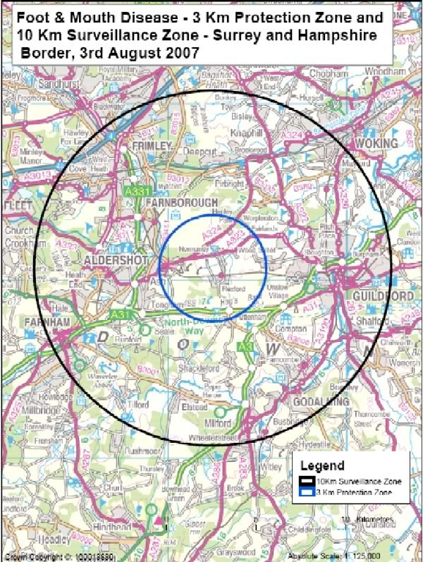
DEFRA has confirmed an outbreak of Foot and Mouth Disease near Guildford and has imposed restrictions around 51° 14.880N 00° 40.572W.
The 3km zone includes geocaches such as GCAF37 A Slice of Christmas Pie which is closely adjacent to a public footpath which runs through the infected farm.
In view of the extremely serious consequences to the country and the countryside arising from the spread of this awful livestock disease, I would strongly recommend that all cachers in the area carefully consider whether they should go into the 3km restricted area at all and should also carefully consider the wisdom of going caching in the 10km zone.
I would also suggest that GC.com give careful consideration to temporarily suspending all the caches within the 3km zone without further delay.
Please be aware that FMD is easily spread by feet and vehicles tyres.
Edited to add the DEFRA sketchmap of the affected area.
-
I don't know how the internal workings of the GPSr prioritise the different (many) longitudes available - it possibly has something to do with satellite signal strengths? - but I'm guessing here...
GPS doesn't 'think' in terms of Lat/Long. Instead it uses Cartesian 3D co-ords.
At the North Pole the Cartesians would be:
X:0.0m
Y:0.0m
Z:+6,356,765.9m
At the South Pole the Cartesians would be:
X:0.0m
Y:0.0m
Z:-6,359,557.8m
Owing to the natural fluctuation of GPS, especially in the absence of WAAS, both the X and Y ordinates would randomly wander a few metres either side of zero. Calculated and displayed Longitude would therefore wander randomly by the resultant of the X and Y ordinates.
By averaging lots of fixes, North Polar ice movement notwithstanding, an accurate fix could be computed, but you'd have to do so with the original Cartesians, not Lat/Longs as non zero X&Y would tend to cancel +ve figures with -ve ones and vice-versa, whereas non 90° Latitudes could only be <90° so averaging Latitude readouts would always produce a Latitude less than 90°.
-
I presume that at the north pole the sun stays at roughly the same elevation all day long, just going all the way around you. There will be a slight change as the sun's elevation rises to a max in mid summer, etc etc..
That doesn't matter much for astronav. Any measured observation makes a line of position. By repeating the measurement a couple of hours later you have an intersection of two lines of position with about 30° angle of cut. Keep repeating and your position becomes more and more accurate. You don't even need to be stationary. So long as you log your direction and distance of movement since the last fix you can compensate for the elapsed distance in the calculation. One of the reasons for the bicycle-like wheel behind the polar exploration sleds, which is an odometer, is to maintain dead-reckoning. The other use for the measured distance data is to enable running fixes to be made whenever the sun or moon is visible for a sextant or theodolite shot. It's a trick which is sometimes used in desert navigation too. 4x4 vehicle wheels spin in soft sand, so the vehicle's odometer is a lousy indicator of actual distance travelled. An old-fashioned bike-wheel odometer out the back of the vehicle is very accurate and can be a lifesaver for the prudent land navigator in harsh desert conditions when the GPS goes wonky.
-
I've always wondered - how would the early explorers know they've gotten to the pole? Scot knew he got there because he saw Amundsen's flag already there - but how did Amundsen know he'd arrived at the pole?
He set up a camp so that he could make astronav observations to measure his position beyond any doubt. There had recently been two cases of suspected scientific fraud by two American showmen who falsely claimed to have reached the North Pole and Amundsen knew that he would have to make meticulous records of his nav calcs to prove that he and his team had actually reached the South pole. Having established the exact co-ords of his station he sent his team to ski to four points around the calculated position of the pole itself, thus effectively boxing it in.
Astro nav is fairly straightforward. It's simply a matter of making timed measurements of the altitude of heavenly bodies such as the Sun, the Moon and any othe the planets and/or any of the 57 navigational stars. Amundsen's theodolite was broken by the time he reach the polar area, so he had to improvise by using his sextant as a theodolite to make the observations. Because he was ashore, and in a very mountainous continent, his sextant could not accurately identify the horizontal plane and he estimated that his fix accuracy was probably something of the order of ±½mile. He therefore ordered his skiers to make their boxin pattern large enough to be quite sure that they had certainly boxed the Pole.
Astronav as way of position-fixing is still practiced today, even after GPS has become ubiquitous. Some specialist military people are taught how to do it so that they can continue to measure position even if GPS is jammed or if their GPSrs have either failed or been lost for some reason. With some patience and perseverence, together with a good stopwatch, it is quite possible to measure position to an accuracy of a few dozen metres or so by astronav alone. Doing the numbercrunching without a programmable calculator or a computer is a pain though.
-
As to the location of true north as shown by a GPS it would be nice if it was 90d 00.000'N, arbitrary E/W but something tells me it isn't that simple. The datum will probably mess things up considerably
It is that simple. The True pole is defined as the spin axis of the Earth. GPS itself doesn't actually 'think' in terms of Lat/Long. That is simply an output format for the user. Within the GPS all co-ords are calculated in 3D Cartesian form. The origin is the infinitely small point within the Earth where the line connecting the two poles intersects with the plane of the Equator. The X axis runs from there to the Equator on the zero degree meridian. The Y axis is perpendicular to the X axis and runs from the origin to the Equator at a Longitude of 90° East. The Z axis runs from the origin top the North Pole. There is a teenyweeny complication in that the Earth's Southern hemisphere is about half a metre bigger than the Northern hemisphere, but that is no problem for polar nav with GPS as everything relates to the poles and the equator, not just the equator. The units of measure are metres, not angular measure.
plus you might only get low angle satellite coverage.Low angle satellites are an advantage, not a disadvantage for position fixing. Satellites which are elevated much more than about 60° above the local horizon are practically useless for obtaining Lat/Long, other than to assist in computing the Time and altitude elements of the four dimensions which a GPSr measures. GPS was designed very specifically to be Global and it works perfectly well in the polar regions, despite the fact that none of the satellites flies much above 56° of Latitude.
-
Click on the Streetmap option on the cachepage;
Copy the image of the map to the clipboard using Ctrl+Print Screen (the button to the right of F12);
Paste the image into the image software of your choice, such as Microsoft's Photo Editor;
Print the image.
-
.........Devising and assuring position fixing methods to align and connect two pipelines in a couple of thousand feet of seawater .........
Boy, The Forester's caches must be hard to find and require specialist equipment!

Funny you should say that! A couple of years ago I seriously investigated the possibility of placing a geocache on the seabed in a very deep part of the Norwegian Trench. I obtained permission in principle, subject to detailed review of course, from one of the reviewers. I obtained a redundant underwater camera housing, which was rated to 2000m depth, as a cache container. As Client Rep I am consulted by the Party Chief when selecting a suitable location for test dives of work class Remote Operated Vehicles (ROVs). We usually choose somewhere a little bit interesting for test dips, such as a mine-like object which has previously only been seen on sonar and hasn't yet been visually identified, or perhaps a poorly doccumented wreck where we can do a little bit of thievery such as nicking the ship's bell for display in the mess or even popping off a shape charge to liberate the phosphor bronze propellor to sell to a dodgy scrappie for some drinking vouchers for the lads.
Cache maintenance wouldn't be much of a problem at my chosen site as there's a major gas field fairly nearby which is often attended by ROVs and I can easily contact either the Party Chief or the Client rep if I'm not aboard myself. The only major problem I ran into was resolving the "permission" issue. Strictly speaking placement of a cache on the seabed would be classed as "dumping" under the UNCLOS regs. That would require government permission. I've dealt with the Noggie government on such matters before and the bureaucracy is a major pain. Another problem to solve would be ensuring that the cache can survive being clobbered by a trawler. That can be achieved but is quite tricky.
Such a cache would certainly rate a 5/5 as the "terrain" is certainly harsh and the "special equipment" involves a million Pound ROV and a £20M support ship which has a current dayrate of around £36,000!
-
Is it this logo?

For some reason that design reminds me of the design of the Pygmy Parliament in Edinburgh. I expect the cost overruns will be just as awful too!
-
I think I'll have that engraved as my epitaph!Crikey there's more to this mapping lark than I ever thought possibleHow do you know so much about this stuff?A couple of years of studying Geodesy at postgrad level and a third of a century of offshore experience of working as a Hydrographer were a good start. Devising and assuring position fixing methods to align and connect two pipelines in a couple of thousand feet of seawater so that the boltholes of the flanges line up in three dimensions and can be connected accurately enough to secure oil or gas at a couple of thousand psi in an environmentally sensitive location concentrates the mind wonderfully. After a few decades of doing that sort of work the simple matter of position fixing onshore in daylight to an accuracy of a couple of metres becomes a piece of the proverbial.
One of the sidelines I do in addition to my 'day' job is occasionally working as a civilian instructor on the directing staff of four units of the UK land forces teaching Advanced Land Navigation to specialist troops or their instructors . My studes aren't awarded marks out of ten, they either pass or fail the course. One of several practical tasks they have to accomplish before passing is to measure the co-ords of a given location in the field to an accuracy better than 7 metres without GPS. Almost all of them pass the course, usually measuring the point to much better than the required standard. For one of the units, a TA outfit in lowland Scotland, I usually give them a task to do an accurate four legged traverse to a point which just happens to have a geocache. They then have to prove to me that they have been there by counting the boughs on a certain tree and then they have to measure the co-ords of the cache. The cache owner is, I'm pretty sure, unaware of the undeclared visitors to his cache though he may be puzzled by a certain mark in the logbook! The co-ords which the successful studes produce are usually within 3 or 4 metres of the actual position. They're not allowed to use anything other than a sighting compass, a piece of knotted string, a pencil, paper and simplified compact trig and log tables and I check their working to ensure that they haven't cheated (much!), but most of them get the co-ords right to an accuracy that a good cacher would be proud of.
-
Here's what to do:
Convert your Lat/Long to OS grid co-ords using a reputable offline utility such as Memory Map or Grid InQuest, or an online utility from a reputable source such as nearby.org.uk or gps.gov.uk. Ignore the crapulous grid co-ords at the top-left corner of the cachepage. They are complete garbage and are a disgrace to DoubleSpeak Inc. They contain many errors massively greater than a mere 20' and should be ignored.
Plot your grid cords on one of the several freebie OS mapping services, such as magic.gov.uk. Those maps show the grid co-ords to single metre precision and are accurate to the OS normal standards which are comparable to a reasonably good quality GPS fix.
If you want to check whether one of the georeferenced image services such as GoogleEarth or VirtualEarth are producing accurate co-ords, simply scale off the co-ords of a recognisable point on the OS map, such as a fence or wall corner or intersection and compare them to the indicated co-ords on the orthorectified image at GoogleEarth. You can apply that translational shift anywhere reasonably close to your co-ordinated point, so long as there isn't a very steep change in height.
The accuracy you can expect from the Ordnance Survey depends on the scale of the survey. For urban and rural areas surveyed at 1:2,500 the errors are <± 2.8 metres. For mountain and moorland areas surveyed at 1:10,000 the OS errors are <± 4.1 metres. These accuracies are comparable in magnitude to the typical error of a single GPS fix.
-
Yup, I'll give that one to Helen.
The WBC hive is named after its designer William Broughton Carr who created the design in 1890. It became the de facto standard in the UK and some parts of the US for most of the 20th century. It's double-wall construction has the charateristic outline which many non-beekeepers and cartoonists associate with the classic shape of a British beehive.

Although in full production and still available from all good merchants of beehives, the WBC has beome superseded by the more modern 'National' design which is single-walled, much more practical in its modular design, but is entirely cuboid and uninterseting in shape.
The navigational connection is that bees are superb navigators, the original cachers in fact. They don't even need a cachepage to tell the rest of the community where the goodies are to be found.
They perform a wiggle dance to indicate the direction and distance to the goodies. The direction is indicated with respect to the sun's direction and the number and vigour of the hip wiggles indicate the distance. It's even cleverer than that. The bees who've been told the bearing and distance to the goodies, which may be a source of pollen or water or nectar, will calculate the effect of crosswinds and immediately fly on the required heading to fly a direct track over the ground to the destination.
Remarkably, it has been shown that if the destination is the other side of the mountain which is too tall to fly over, they will fly around the mountain, knowing that the destination lies on the given bearing and that the indicated distance is the circumferential distance around the mountain to the site.
Even more remarkable is the ability to take into account the spherical shape of the Earth shown by scouts during a swarm. Although a swarm pigs out on honey in preparation for the swarm, time is not unlimited as they have left all their stores of pollen and honey back at the hive from which they have emigrated. The beachball-sized cluster of bees, usually clinging to a tree or a large shrub, waits eagerly for the scouts to bring news of a suitable location for a new nest-site and the search goes on 24 hours a day. Even at night, with the sun clearly round the other side of the Earth, the scout bee telling its chums of the co-ords (in rho-theta format) uses the position of the sun as the azimuth datum to indicate the direction for the tribe to fly to the entrance to the new abode. That requires, if not an understanding of, then at least an ability to compute bearings with a knowledge of the sun's position in three dimensions at any time of night. Now that's clever!
-
Good guesses.
-
At this time of year they're very busy little navigators.
-
WBC was originally the initals of a man, who had no particular navigational connections so far as I know, but is now very much connected with an item which is very closely connected to some of the best navigators around.
-
Staying with a vaguely navigational theme and initials, what do the letters WBC represent?
-
NavStar isn't an acronym. It's the proper 'brand' name of America's current GPS. It's one of half a dozen or so Global Positioning Systems but tends to be referred to by its generic name of GPS.
NMEA is the National Marine Electronics Association. They drafted a standard format for GPS to talk to boats' autopilots etc and it became a de facto standard for all sorts of GPS data transfer.
GNSS is Global Navigation Satellite System. It's actually synonymous with GPS, but the name GPS has taken over in common useage from the more correct name of NavStar
RKP is Relative Kinematic Positioning. It's a way of using GPS data by comparing the phase of the satellite signals instead of treating the data as pseudo-range measurements. It's the way grown-up GPSrs measure position. The acronym is sometimes used interchangeably with the more widely used acronym of RTK (RealTime Kinematic).
Glonass is Global Navigation Satellite System, just like GNSS, except it's the brand name of the Russian GPS. It uses the same principles as NavStar but never had the absurd Selective Availability and was, for a few years, actually better than NavStar GPS. It fell into semi-dereliction through lack of funding after the Russian Federation lost its former Soviet structure, but it's now seeing something of a resurgence as people around the world begin to mistrust and even distrust US military control of something as vital to modern life as GPS.

XMAS Day Cachers
in United Kingdom and Ireland
Posted
Does Boxing Day count?