

The Forester
-
Posts
1433 -
Joined
-
Last visited
Posts posted by The Forester
-
-
Will you tell them that they're not whales, or do you want me to?

-
One difference that immediately springs to mind may not be the one you're looking for.
Belugas have no dorsal fin. That's one of the reasons why they are so at home in the Arctic under ice.
Orcas regularly come to grief in the Norwegian fjords in winter. The ice there is mostly freshwater ice from waterfall runoff. The Orcas have huge dorsal fins and they rip them to shreds when desperately trying to find a lead or a polynya in the ice. Because that huge dorsal fin sticks up a couple of metres and is some way behind the blowhole they just can't make use of small gaps in the ice to breathe, so they drown. I've seen it for myself. Very distressing to be able t odo nothing to help the poor blighters. I suspect that drowning must be the worst imaginable death for a marine mammal.
Perhaps that's the reason why the Belugas always have that silly grin. They're giggling at the stoopid killer whales!
-
That's a good Ding to Keehotee.
QI was where I discovered that little bijou.
Fry is right, by the way. I checked before uploading the question. I asked a chap whose surname is Singh. Seemed a pretty good credential to me!
-
Lithping ith not involved.
-
They came from countries which didn't have mechanical aids such as tractors.
They came from countries which didn't have any untouched prairies to rip up with plough and harrow, so they had no way of knowing what the effect would be on the physical structure of the virgin soil and the resultant climate changes.
Many of them came from NorthWestern European countries which have a temperate maritime climate, so they didn't understand that places like the Texas panhandle and Kansas have a completely different type of climate with vastly greater extremes.
They came from tiny peasant owned farms, where they tilled the soil symapthetically with oxen and fed the land with the manure of farm animals. They passed the land down through generations and they cared for the land. They emigrated to a land where they could only be tenants or "sharecroppers". It was/is a land where "greed is good" and where the pursuit of the fast Buck is not only a way of life, it's almost a religion. They stopped thinking 10, 30 or a 100 years ahead. In fact, they stopped thinking at all. They blindly and stupidly chased a fast buck here and now, instead of thinking strategically about what was good for the land and what was good for the future.
Now their descendants are doing the same thing to the globe's atmosphere as the stupid ones did to a hundred million acres of topsoil in the 1920s.
This is not a political matter at all. It's human geography and human geography is inseparable from any other other kind of geography. Geography is what we see all around us when geocaching and when surfing websites such as Google Earth et al.
I should also point out that the sharecroppers of 1920s America certainly don't have a monopoly on stupidity. Nor is it limited to the New World. Indonesian and Brazilian strip-logging of primary rainforest are prime examples of the moral equivalence of New World and Third World stupidity.
It doesn't have to be like that though. For many years, almost a decade, I lobbied the Noggie Parliament to have Wangari Maathai nominated for a Nobel Prize. Currently my hero is Willie Smits. He's an Indonesian who is intelligently repairing the damage done to the rainforests of Borneo and Sumatra. He's quietly and effectively showing the difference between stupidity and intelligent husbandry of the land. If you have 20 minutes to spare and can listen to an audio track of a streamed video, then I would urge you to listen to his TED Talk on how he is rebuilding a rainforest from scratch].
-
Hence my reference to Blorenge. Many people thought that orange doesn't have any rhyming words.
Month does have a rhyming word. It's in quite common useage in the UK (and elsewhere in Anglophone and some other countries).
-
Here's one I think the Blorenges can probably answer:
What word rhymes with 'month'?
-
Here goes:
We think the link is that all three records were reorded on twin groove vinyl. On the Kate Bush album, for example, if you placed the stylus in one groove you could listen to the normal vocals, the other groove played the instrumental version.
My chum experimented with a few whacky vinyl technologies in the 1970s, including a now defunct method of recording video onto LP's. His idea was to combine video with pop music. It was an idea ahead of its time and the technology wasn't quite up to it. He produced the world's first video for the system which RCA were going to launch as "capacitive electronic disks". He worked with Michael Nesmith (Monkee) and Kevin McCormick (went on the produce Saturday Night Fever) and William Dear who went on to direct Harry & The Hendersons and some other guff that I've never heard of. RCA got cold feet and pulled the plug on the technology, thinking that nobody would ever want to watch a pop video.

-
Are we allowed to consult a houseguest?
I have a guest whose name is Mr Bean, yes really!, and he owns a record label in California. He's told me the connection, technically. Am I allowed to blow the gaff on that basis?
-
The corrective measure which were taken to combat the dust bowl certainly have worked. Old lessons were relearned, such as the need for crop rotation. Government instigated practices, such as contour ploughing, are still in use to this day, as has been shown in the satellite/aerial photographs above.
I don't know whether such measures could be mandated by government today. There would be a great deal of resistance to the nanny state getting involved in private enterprise such as farming.
-
And protecting recently seeded land from wind? Or am I mixing that up with something else?
You're right, but not quite right.
The wind-borne "dust bowl" was an effect, not a cause. The underlying cause of the problem was incompetent farming methods which ripped the heart out of the topsoil, thus rendering it extremely vulnerable to being lifted by wind. 1930s farmers often described thew sight of seeing newly sown seeds being ripped out of the land by quite moderate winds. That was because the very structure of the topsoil had been grievously damaged by stupid farming techniques.
Contour ploughing, and contour bunding, is basically a variant of terrace farming which had been practiced wisely in the "Old World" for millennia.
-
I'm intrigued by the patchwork effect around this area - are the locals encouraged to do their own lunar landscaping??
It's called contour ploughing. It was introduced in the 1930s as a way of reducing the rain-washed "dustbowl". By ploughing along the lines of the contours water runoff is greatly slowed down and percolation is much more effective.
-
Milvus gets the Ding.
Before GPS came along, most countries used theodolities to measure angles between triangulation points. A Baseline was measured between at least two of those points to give the lattice-like trig framework scale and then the whole thing was pinned to Lat/Long at a single, carefully measured, astro-geodetic point.
For Europe in the second half of the 20th century the Origin of the European Datum 1950 was Helmert's Tower in Potsdam.
If you delve into the nether pages of your GPSr you'll find a list of about a hundred or so such datums, one of which is NAD27. When the Murricane surveyors who surveyed in the point at Meades Ranch did their thing in 1927 they made a complete arse of the job. Being a very insular nation, nobody noticed or even cared.
Once the first artificial satellite was launched, people started noting the Doppler whistle effect and could measure the precise orbital parameters visually. Combining a measurement of the satellite's position with the 4-D spatial point which was identifiable by its Doppler null point gave a single line of position on Earth. Do enough of those measurements (80 well spaced measurements is a practical minimum) and you've got a pretty good measure of your observation point's co-ords on your chosen spheroid.
By the late 1950s it became very obvious that the stated co-ords of the Origin of North American Datum 1927, at Meades Ranch, was a load of bolleaux. What any reasonable nation would have done would have been to create a new Datum, let's call it NAD63, to bring that datum point into line geodetically with what the already agreed definition of what zero degrees Longitude (Greenwich Meridian) actually means. We are not talking about a reasonable nation though. The Murricanes simply declared that the entire world was out of step with Murrica, so they sang a hymn and they steadfastly insisted on propagating their error by carrying it over into NAD63 and WGS72 and WGS84. Now we're stuck with it.
They did something similar with their absurd claims that an independent and reuinified Vietnam would lead to a Domino Effect and that Iraq was full of Weapons of Mass Destruction and that Afghans were involved in 9/11, but that's political geography, not geodetic geography, so we'll say no more.
May their god Bless 'em.
-
I like your thinking, Rutson!


You are so close!!
-
Your thinking is good, Rutson.
Now answer the question!
-
Looking at the number of views I think quite a few geocachers will quietly kick themselves when they see the answer to this one. It really is of relevance to all geocachers, not just North American ones.
For my next clue, take a look at Google Earth or Flashearth or whatever, imagery for Greenwich. Pay particular attention to how badly wrong the Longitude lines are. Then think about why they appear to be so wrong. The "error" is well over a hundred metres. Ask yourself: Why?
-
Most countries have one of these. Some countries, such as much of Western Europe shares a single one, such the one in Potsdam.
Greenland has one at 64° 31.026N 51° 12.146W.
-
What a strange name for a woman!
Hellig Olav was a man!!
-
When I was a Boy Scout we had a ribald song about Being Prepared --- for Girl Guides.
I seem to recall a rather rude verse about the Head Guide in which she was compared to Olive Oyl.
So I'll say Mrs Powell was called Olive.
-
Time for another clue.
This precise location is of great significance to geocachers.
-
And there was me thinking farmers just flung cow sh1t everywehere once in a while.

No, that's politicians who do that.
Now that I've seem my own MP's expense account, I think farmers dispense a lot less bullsh1t, and much more cheaply, than politicians do.
-
Panic over. Stoopid Murricane "surveyors" had been using the wrong datum and wondered why their pipe-crossing co-ordinates were more carp than usual.
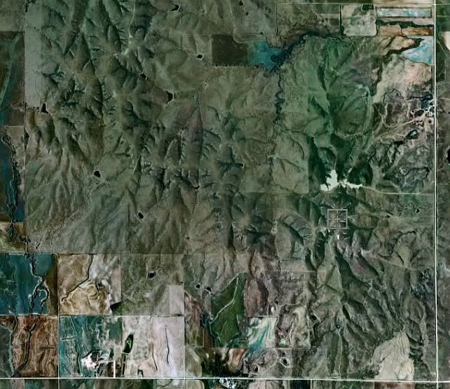
OK, staying with the same continent, here are two pictures of the same marked location, at different scales.
I want the name of either one of the two caches in the vicinity which are relevant to this exact spot.
and
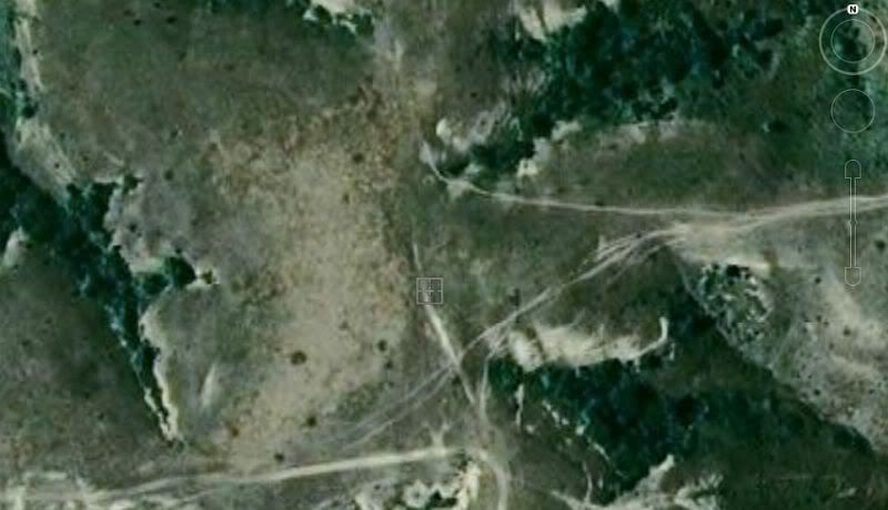
I think I've already given quite enough clues already.
-
He's soil sampling.
Modern crop sprayers and fertiliser spreaders have a digital map of the field and every single square metre ("bin") of the field has its own dosage prescription of whatever nutrients of agrichems it needs. The prescription package is updated by satellite at least once a year, usually much more often than that, but the remote sensing data has to be calibrated with the "ground truth".
What you've seen is a sampler taking samples from position-logged positions to calibrate the system.
If you watch a modern crop-sprayer, you'll see the individual nozzles constantly flickering as they adjust to whichever square metre that nozzle is covering at that instant. Quite often you'll see several, or even all, nozzles switching off entirely.
It makes a massive saving for the farmer as it avoids overdosing and underdosing. It's also very good for the rivers and other watercourses as it almost eliminates excessive applications of stuff such as nitrogeneous fertiilsers which otherwise runs off the fields and causes serious pollution problems downstream and even in estuaries.
-
I'll get another picture up in a few hours. I'm a bit busy dealing with a panic in the Gulf of Mexico at the moment.


The All New All New Groundspeak UK Pub Quiz
in United Kingdom and Ireland
Posted
All of 'em.
It's the standard title for any Ambassador to the UK.
It's something to do with the fact that traditionally a Royal Court was quite mobile, so an Ambassador's title would have to change dozens of times a year. They (whoever "they" are) decided to simplify by making one single Court the designated location to which ambassadors were, err, ambassadors. They chose the oldest Court, which was St James's.
The reason why I know is that my first ever bank account was a Post Office savings account which I proudly opened at the delightfully quaint PO at the Palace of St James at the age of 7, with a shilling which my great-aunt Phoebe gave me to start me off at my first term at boarding school. I still remember those flint-lined walls today! As a kid I always thought of my money in that account being held somewhere deep inside St James's, carefully guarded by enormously tall Guardsmen in red tunics and huge bearskin hats. Whenever I heard the name of St James I always paid close attention in case it might affect my precious shillings.