


balga
-
Posts
25 -
Joined
-
Last visited
Posts posted by balga
-
-
Anyway, what I need to know is, can I connect the device to my laptop to download the waypoints instead? It would save us so much time.
Thanks

You need a data cable.
If your notebook does not have a serial port you need a serial to USB coonverter too.
It has been discussed in this forum before - i do not find the article.
Garmin Shop:
PC Interface Cable (RS232 Serial Port Connector)
010-10206-00
USB to RS232 Converter Cable (Requires Applicable Unit PC Interface Cable)
010-10310-00
Original Garmin equipment is more expensive than third party products.
Software for creating / transfering data to the GPS: Mapsource works, OziExplorer works. Lots of other free and commercial SW works.
-
A Geko 201 is serial, not USB. To connect it to a USB port, you would need Garmin PN 010-10206-00 AND Garmin PN 010-10310-00. Nope, it's not cheap. The second cable could be replaced by a serial to USB adaptor.
Unfortunately there is no single solution to the problem.
1) Garmin PN 010-10206-00
PC Interface Cable (RS232 Serial Port Connector) $38
Should be available second hand.
2) PN 010-10310-00
USB to RS232 converter cable from garmin: $60
USB to RS232 converter noname starting at $10.
I got a noname adapter a few years back - it is still working.
-
I think we should collect the data of affected devices. May be this can narrow down the possible causes.
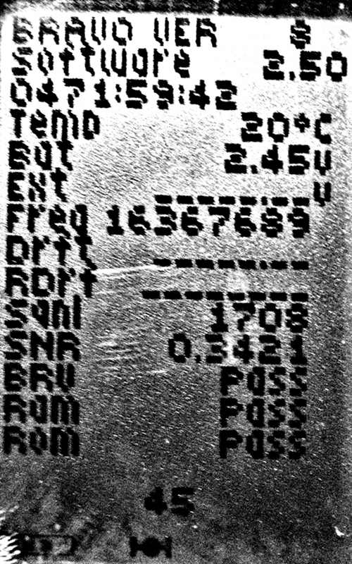
Hold down OK while switching on the Geko and you get this screen:
http://www.andreas-weller.de/usenet/geko201-2010.jpg
Interesting for comparison:
Bravo Version 8 (Hardware)
Software 2.50 (Firmware)
As you can see direct below software: wrong time :-(
With my geko 301 I get
Bravo Version 204
Software 2.70
see geko_301_sys.jpg
My Date / Time is still correct - but the time I see below "software" is different to the correct time shown on other screens.
For the Geko 201 there is also a Software 2.70 available - never tried an update?
Update:
The time below "software" on the system info screen seems to be the overall sysup time.
That time just continues after restart of the geko.
So my geko was running about 24 full days (about 72 hiking days). Do not know if a system reset and sw update resets that time too.
-
Uploading maps to my colorado using MapSource. It doesn't give me the option to change the .img filename before uploading.
When I make a change to one of the maps, if I try to upload the one area I changed, it overwrites all the maps.
How do you change just one segment, etc. without it overwriting the whole map. Can you change the .img filename on the unit and have it still work?
see http://garmincolorado.wikispaces.com/Maps#toc14
and following
-
I have started my good old geko 301 i did not use since 2 years.
No date issue - after about 10 Minutes i got correct time and a fix.
-
Once, after a Master Reset, (Software Version 2.4 or 2.5) my Colorado restarted the tracks log numbering with 1.gpx.
I have never redone a master reset since then - and the log file names behave as expected.
-
I have a colorado 300.
There are two pros on the colorado, very useful in some occasions:
- possibility to attach an external antenne - I get a good signal in" difficult places" for example: In "modern trains" or even "in house" the external antenna can make the difference.
- the hot swappable SD Card, no need to restart the gps after changing maps. As I play around with own maps (and TYPs) it is very convenient to test modifications.
- possibility to attach an external antenne - I get a good signal in" difficult places" for example: In "modern trains" or even "in house" the external antenna can make the difference.
-
Can anybody point me in the direction of a decent walk-through showing me the steps I need to follow in order to end up with customised map features?
Thanks in advance.
Starting with TYP's may be, until you have a working procedure, frustrating.
The procedure I used:
1) Grab an existing TYP File and decompile it
(for Example with MapTk, Tools -> TYP Analysis
will create a prj File in the Directory of the TYP File)
(if you have maps without TYP files - get one like the following (German / Italien Site):
http://www.garda-gps.de/download/GardaGPS.typ)
2) Have a look into the created Textfile (GardaGPS.typ.prj) - its quite readable, just a sample with lines and bitmaps out of it:
[Polyline]
Type=0x0a
String=2,Fahrweg
String=5,Strada Regionale
Linewidth=2
Color=0,0x009500
[END]
[Polyline]
Type=0x16
String=2,Trail
String=5,Trail
Color=0,0x009500
Line=00000011000000110000001100000011
Line=00000011000000110000001100000011
[END]
3) Modify one Type
(MapTk: File -> Edit Project File -> Selecte the prj File generated before)
Modify Types
If you start with Type 0x03 or 0x04 or 0x05
most probably these Types are used on your map.
Check the modified prj File.
4) Compile it -
set the correct Famliy ID in the prj File - TYP Files need the Family ID for the Map used.
(MapTk: press the TYP Button)
5) Register it.
(MapTk creates a reg file)
I copied the Type File to the original place - the map I played around with had a registred TYP File.
6) Test it in Mapsource
Mapsource (6.14.1) keeps a TileCache so:
Stop Mapsource,
Delete the Cache
(c:\Dokumente und Einstellungen\<u s e r>\Anwendungsdaten\GARMIN\MapSource\TileCache\)
(~c:\Documents and Settings\<u s e r>\Appliationdata\GARMIN\MapSource\TileCache\)
Restart Mapsource.
7) Test on the GPS
Recreate and send the Map to the GPS.
8) find out about the Types you realy want to modify
Restart the process
Maps using proprietary Types should have a TYP file (decompile it).
The common Types (like higway, trail, forrest, ...) are known within the tools editor
(example: GenTYP or online editor at http://ati.land.cz/gps/typdecomp/editor.cgi ).
-
Balga, what is a TYP file and can it be edited on the Garmin brand maps? I like those preview images and can see some great potential.
Other entry points to TypFiles:
Online Editor
http://ati.land.cz/gps/typdecomp/editor.cgi
Another Editor:
http://www.maptk.dnsalias.com/
Sample Swisstopo (Family 703)
If a Map uses custom Types you will find a Type File in
C:\Garmin\FAM_703\I00002BF.TYP
Typ Files are per "Family"
And there is a Registr Entries for Mapsource pointing to the Type File:
[HKEY_LOCAL_MACHINE\SOFTWARE\Garmin\Mapsource\Families\FAMILY_703]
"ID"=hex:bf,02
"IDX"="C:\\Garmin\\FAM_703\\product.mdx"
"MDR"="C:\\Garmin\\FAM_703\\MDRMAP.img"
"TYP"="C:\\Garmin\\FAM_703\\I00002BF.TYP"
Probably it works to create a new Custom Type File for a Map family and register them for Mapsource.
It seems that the different tools create different "quality" of Typefiles.
Its your own risk to play around - with the Colorado I had no issues.
I heard that people with a 60 CSx it is no so straightforward.
There should be threads in other forums about that topic may be soneone can point to them.
-
Topo USA is really bad because of the relief shading colors, which until recently could not be turned off.
I personally like the relief shading and elevation colors, except for the fact that it makes other map features nearly invisible. The worst example of this is the light grey lines of small streets at the 0.2-0.5 mi zoom level. Against a white background, they are barely visible. Against the greens/browns of Topo 2008, they are practically invisible. Turn on relief shading and they completely disappear. I don't know why somebody would choose such light colors for important map features.
Since I heard a few days ago about the TYP Files for maps I am playing around with it.
The links below show you samples (two different Zoom Levels, Swisstopo Map, small village in the mountains).
The left one is the "original".
The middle one is creatd by someone else.
The right one is my actual favorite.
Even Mapsource shows the same TYP's (third link).
http://balga.ch/colo300/TypeSample200.jpg
http://balga.ch/colo300/TypeSample80.jpg
http://balga.ch/colo300/TypeSampleMapsource.jpg
I guess that is possible with other topo maps too.
-
No Support for Waypoint, Tracks and Routes
Support for real-time position and time as far as I have seen.
Not in Spanner mode. You access those in drive mode.
What is drive mode?
In Setup -> Interface -> I can choose
- Garmin Spanner
- Garmin Serial
- NMEA In/Out
- Text Out
- RTCM
Did I miss a setting?
Setting the CO to Garmin Spanner lets me connect the CO with my Computer via USB, not switching the CO to masstorage and communicate with compatible programs.
I have tried gpsbabel and OziExplorer, both using the Garmin PVT protocol
(The Spanner Program available for Windows PC's translats the PVT into a serial NMEA protocol).
Wih OziExplorer a can use "Moving Map" (real-time position) but not sending or receiving routes, tracks and waypoints from / to the CO.
With gpsbabel I can write tracklogs on the pc but not more.
-
* Access to GPS functions when connected to computer
Yes you can with Spanner for the last few revisions.
No Support for Waypoint, Tracks and Routes
Support for real-time position and time as far as I have seen.
-
I'd be curious what other people are observing with respect to GPS altitude and WAAS if you've updated to GPS 2.8.
Started my Colorado 300 this morning
- the altitude is within the range I had before,
- WAAS I get within 2 Minutes (on satellite 33, already found after the update but I did not notice how long it took, dit not disable / enabled WAAS after update)
- EPE: nothing special
Evening, same location: no WAAS at all (did not toggle WAAS off / on)
Next Morning: WAAS again (I checked 5 minutes after starting device, device off during night)
As I do not remember how well WAAS performed with the old chipset SW my observations are not very useful.
-
I'd be curious what other people are observing with respect to GPS altitude and WAAS if you've updated to GPS 2.8.
Started my Colorado 300 this morning
- the altitude is within the range I had before,
- WAAS I get within 2 Minutes (on satellite 33, already found after the update but I did not notice how long it took, dit not disable / enabled WAAS after update)
- EPE: nothing special
-
Update worked see:
http://forums.Groundspeak.com/GC/index.php?showtopic=205915
Colorado 300 is still working.
-
Just updated to system FW 2.80 for my Vista HCx, and got this as well under "additional updates". I have also updated the wife's Venture HC. So yes, it'd definitely for the etrex H series Mediatek chipset, and I assume also Colorado's with the same chipset.
Same with Colorado 300, got it under "Additional Updates":


-
software version 2.70
Fixed issues with power off pressure trending.
Switched off CO 10 pm
Switched on CO 8 am
Compared pressure trending with a nearby weatherstation
-> see picture , looks correct

the full picture from the colordo so scales are also readable.

-
Out of Changes made from version 2.51 to 2.54:
- Improved map drawing to enhance appearance of trails
Does somebody know what that enhancement means?
I do not see any differenc with my Topo maps.
- Improved map drawing to enhance appearance of trails
-
-
- how do i reduce the number of points. My routes have usually 500 points approx. thanks.
Manualy (I do not know of a program doing that automatic - but that kind of program may exist)
Open the route in MapSource and delete some waypoints.
Within the route editor use "Show on Map" (bottom right) and it gives a good overview for the route.
Without a (topo) map it may be difficult to simplify the route.
-
Hello. Can I download a routes created with mapsource (CN2008) to the geko 201? Theses routes are mainly used on 60csx.
thanks.
Is possible.
You need a garmin serial cable for the geko.
Make sure the route length is within the GEKO's limit, maximum 20 routes with 125 waypoints each
(I have a geko 301)
-
Scanned and vectorized paper topo map + tourist trail map (red trail) together on screen:
I want to create a transparent tourist trail map (to display over my Topo Map)
The "tourist trails" I can export as route or track into a gpx file.
In GPSMapEdit (not yet registred) I import these file(s),
transform the routes to a polyline and delete the waypoints.
The LineTypes are predefined from 0x01 to 0x2b.
The 0x16 Walkway trail gives just a thin black dashed line.
Is there a way to create custom line types visible in mapsource and on the colorado?
Is it another predefined type visible as red dashed line on the colorado?
-
I am not a geocacher, I use it for hiking, biking and tracking (even in trains)
It is my first mapping GPS (before: GEKO 301).
I like it! (Maps: TOPO Suisse 1.1 and City Navigator NT Europe)
Most bothering for me (waiting for fixes)
- Topo Maps with DEM hard to read in certain situations display / colors too dark
( a small black path in a dark green forest is almost not visible,
the brown grade elevation is mistaken as a path on a green background)
- Position failures may occure
That issue is discussed in several places
Example: I had a differencs of 90 Meters (GPS Accuracy shown 9m),
after rebooting the Colorado the position was immediatly correct within the accuracy)
-
I am trying to use my Colorado together with Ozi, but have some problems. On my old PC (XP) it works fine both in "spanner mode" and PVT mode to get the position into Ozi and track where you are. BUT I can´t upload waypoints or routes from Ozi to Colorado. Has anybody succeded with this.
Furter more, on my new PC I have Vista and it seams that spanner doesn´t support that. Is that right, or am I searhing on the wrong place?
Sorry for any strange english, my native language is swedish.
Colorados PVT supports up to now only Position (Moving Map in OZI).
Up- / downloads of routes waypoints and tracks are not working
With the Spanner SW, Virtual COM Port on a Windows XP it does not work reliable.
With gpsbabel ( http://www.gpsbabel.org/ ) reading the position form the Colorado and saving as track in a file works fine on Windows XP and Linux.
/usr/bin/gpsbabel -T -i garmin -f usb: -o kml -F track.kml
/usr/bin/gpsbabel -D2 -T -i garmin -f usb:
...
Capability A919:
Capability A1010:
Capability A918: D918
Link_type 1 Device_command 0
Waypoint: Transfer -1 Type -1
Route: Transfer -1 Header -1 Type -1
Track: Transfer -1 Type -1
Sat Apr 12 18:13:04 2008
47.366243N 8.545481E 471.899902
Sat Apr 12 18:13:05 2008
47.366243N 8.545481E 471.899902

help with a geko
in GPS technology and devices
Posted
1) go to the page with trip data
2) press OK
- you get 4 options CHANGE FIELDS / RESET MAX SPED / RESET TRIP DATA / RESTORE DEFAULTS
3) selsct RESET TRIP DATA - press OK