


gpsvisualizer
-
Posts
151 -
Joined
-
Last visited
Posts posted by gpsvisualizer
-
-
FYI, REI's prices now match Garmin's. I don't know what's going on with Amazon.
-
I checked Amazon today and they had raised the price of the 64s to $340 (and an even bigger hike on the 64st). I thought I better get moving so I ordered a 64s from GPS City for $300 (Where I bought my Oregon 600 - free shipping and no tax). Amazon's price hike may not be a trend as their prices can be volatile, but I thought I'd grab a 64s for the $300 price just in case.
Garmin's site is still showing the new lower prices that appeared last week ($250 for the 64, $300 for the 64S, etc.). I'm guessing it's a permanent change... I'm just waiting for REI to catch on, so I can get the 10% dividend plus a 5% bonus for paying with their Visa card.
-
Also, the low-end model (GPSMAP 64) went down to $250. It might be time to replace my old beat-up 60cx.
Looks like the 64 dropped $50, the 64s dropped $100, and the 64st dropped $150!
-
You can actually draw multiple circles on a map with GPS Visualizer too. Just convert your file (any kind of file) to plain text (using http://www.gpsvisualizer.com/convert), open it in Excel, add a new column called "circle_radius," fill it with distances, and send the file back through GPS Visualizer's map form.
More info here: http://www.gpsvisualizer.com/examples/range_rings.html
-
Is there a special setting on Google Earth that will allow me to view the track overlay?
That example was created with GPS Visualizer's Google Earth form: http://www.gpsvisualizer.com/map_input?form=googleearth
To get the "wall" look, be sure to set altitude mode to "extruded." This graphic also had the track colorized by altitude.
-
I'm the owner of GPS Visualizer. I noticed that the image that "coggins" posted wasn't showing up due to my server configuration... so I've adjusted it, and the 3-D map example should be visible now.
-
I have updated GPS Visualizer's "KML Overlay" tool to make it more compatible with the new Garmin update.
Here's an input form if you want to start from a GPS data file or from a pair of coordinates: http://www.gpsvisualizer.com/kml_overlay?garmin_custom_map=1
And here's a new Garmin-friendly "network link" for use inside Google Earth: http://www.gpsvisualizer.com/google_earth/...twork_link.html
The .kmz files that GPS Visualizer creates (with USGS or NRCan topos inside them) should work right out-of-the-box with the new Garmin software. Please let me know if something goes awry.
-
Yeah, there doesn't seem to be any easy way to do this that I've found. However this overlay tool works very well for USGS Topos and the B/W orthos (I know this probably doesn't help our friends in Canada!).
http://www.gpsvisualizer.com/kml_overlay
You need to save the file locally first but it is a pretty easy way to get topo tiles on the unit.
I don't have a fancy new Garmin unit to test it with, but I think it might work without any extra steps if you select "Static" for "Ground Overlay type" in GPS Visualizer's KML Overlay input form.
http://www.gpsvisualizer.com/kml_overlay?k..._dimension=1024
And as I think someone else mentioned, Canadian topo maps are indeed available. They're not as nice as the USGS topos (or MyTopo.com tiles), but they're something.
-
(oops, duplicate post due to technical difficulties...)
-
If you use GPS Visualizer's Google Earth form (http://www.gpsvisualizer.com/map_input?form=googleearth) to create KML from your .gdb or .gpx file (rather than going straight from Mapsource to GE), the trackpoints will NOT be drawn by default. And if you do choose to have them (using the "Draw trackpoints as waypoints" feature), they will be small unobtrusive circles that are the same color as the track they belong to... NOT big white squares.
-
If you have Google Earth, you may be able to skip a few steps (and avoid having to mess with the GmapToGPX bookmarklet) by simply asking for the directions in Google Earth, saving them as KML, and then converting the KML file to your device's format using GPSBabel.
-
This kind person has an on-line utility that in an interface to GPSBabel. I've converted between several file formats using it. Many thanks to the people that made this possible!!
You're welcome.

-
It looks like Google has not yet created a way to get a KML file into "My Maps," but I'll bet it'll happen soon. Meanwhile, it's very easy to do this:
http://maps.google.com/?q=[url_of_a_KML_file]
Here's an example that will only work for a couple days -- because .kmz files on GPSVisualizer.com are temporary -- but you get the idea:
http://maps.google.com/?q=http://www.gpsvi....220.72.218.kmz
-
Did you know Google Maps can read KML? If you can get your data into KML format and put it on the Web somewhere, you can quickly make a Google Map out of it using Google's own interface.
-
GE is endless fun. Thanks a bunch to http://gpsvisualizer.com/ for making it happen.
You're welcome.

-
At the top of the map window in GE do you have a little clock with a shaded bar next to it?
See, this is why I have GPS Visualizer NOT embed timestamps by default. Too many people got confused by invisible data.
-
-
I'm the owner of GPS Visualizer. Both my site and batchgeocode.com will find the coordinates of street addresses, but here's what I'd recommend:
1) Go to batchgeocode.com and convert your addresses. It'll be slow -- 1-2 seconds per address -- but probably pretty accurate, because they use the Yahoo! Geocoding API for all addresses. (GPS Visualizer is faster but primarily uses a local copy of a Census Bureau database which is less accurate and less tolerant of funky input; also, GPS Visualizer will only do 400 at once.)
2) Copy and paste the geocoded output from batchgeocode.com into GPS Visualizer's "convert" form: http://www.gpsvisualizer.com/convert?convert_output=gpx
3) If you want, rename a couple of fields in your data to "name" and "desc"; or, just leave them be, and GPS Visualizer will probably build names and descriptions for you.
3) Click the "Convert" button. Voila.
-
GPS Visualizer's "Quick Geocoder" will do non-North American addresses, as long as it's in a country that Google has data for: http://www.gpsvisualizer.com/geocode
-
I think the best site, hands-down, for what you're describing is the Acme Mapper: http://mapper.acme.com/
-
[ I use GPS Visualizer to make a reliable .kml file from the .loc waypoint files you can download
Another useful feature of GPSVisualizer.com: the ability to get alternate map/image overlays in Google Earth. See this page for details: http://www.gpsvisualizer.com/misc/kml_network_link.html
For example, up on Mount Hood, I find that GE's fancy color satellite imagery is off by tens of meters; you can easily see that the shadows of ridges don't line up with the ridges themselves! But when I use the GPS Visualizer network link to bring in a USGS 1m aerial photo overlay, it's spot-on.
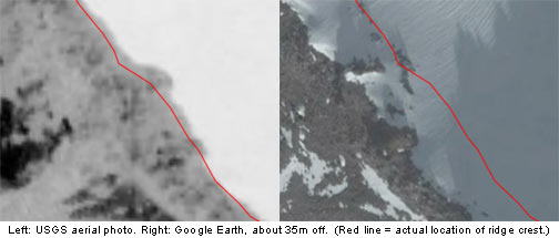
Not as high-resolution as the more recent GE imagery, but far more accurate -- and it's been my experience that the USGS aerials are accurate almost everywhere.
(For those of you in Canada, there are a few NRCan overlays available too.)
-
If I need to find the coordinates of a point that I can easily locate on a map but which doesn't necessarily have an address -- like an intersection of two Nat'l Forest roads, or a stream crossing -- I use the Acme Mapper: http://mapper.acme.com/. It will try to locate addresses for you, and you can fine-tune the results by simply moving the Google map around.
(The maps created by GPS Visualizer also have some Acme-like features these days: specifically, a crosshair in the center of the map with a readout of the crosshair's coordinates.)
-
Start by Googling and then downloading either G7toWin or GPSBabel; those are both free programs that can read the data from your receiver and save it as a GPX file. From there, GPS Visualizer can help you make maps out of your data.
-
I assume you are using a Windows machine. If so, you can download tracks from your GPSR to Google Earth by using GPS Visualizer: http://www.gpsvisualizer.com/map?form=googleearth
...Assuming he's saved the GPSr's track to a compatible format like GPX. Obviously, being a Web-based utility, GPS Visualizer can't actually retrieve information from your receiver.
Garmin GPSMap 64s Price Drop
in GPS technology and devices
Posted
But, if you have an REI membership, you'll get 10% back as a dividend at the end of the year. (Plus, you can take it back if anything ever goes wrong with it.)