

Rubberhead
-
Posts
776 -
Joined
-
Last visited
Everything posted by Rubberhead
-
your opinion on garmin etrex legend?
Rubberhead replied to bluz's topic in GPS technology and devices
The best hunting and fishing times is great for predicting deer movements. Duck hunting is best when the best hunting time coincides with sunrise. I fish saltwater so I've found the tides to be a better indicator of the best fishing times. However, I'm sure that there's a direct correlation between tides and the predicted best times. I’ve just never bothered to try to figure out what it is. -
your opinion on garmin etrex legend?
Rubberhead replied to bluz's topic in GPS technology and devices
bluz, I duck hunt and fish (saltwater inshore and offshore). I had a Venture but recently upgraded to a Legend. The Legend is perfect for me. I even find the Calendar, Sun and Moon and best hunting and fishing times very useful in planning my hunting and fishing trips. I can not even complian about signal strength since I always get good reception when I'm on the water. -
Downloading waypoints to mapsource software.
Rubberhead replied to Timcup's topic in GPS technology and devices
No, Mapsource is not compatible with EasyGPS. Your best bet is to upload the information into your GPS from EasyGPS then download and save it from Mapsource. -
Has anyone submersed their Legend?
Rubberhead replied to HobieTramps's topic in GPS technology and devices
I took an unexpected swim while duck hunting in salt water last year. I had a Garmin eTrex in my pocket when this happened. Anyway, the unit was fine and even continued to work (after I got out of the water). When I got home I opened the battery compartment and cleaned it with fresh water and a rag sprayed with WD40. No problems since. -
Your GPS sounds broke - send it back.
-
I do PDAs for a living. Wait until November. Dell has a really sweet offering that, if nothing else, will put price pressures on the other providers. If you insist on a Palm device, the M130 is not bad.
-
Compass w/o a built-in electronic compass
Rubberhead replied to Rubberhead's topic in GPS technology and devices
Victor Stanescu You are aboslutely right. This is just a pointer on the compass screen for those of us used to having a needle on our compasses. -
I have a waypoint I call NORTH that is N 90º 00.000' latitude. Longitude doesn't matter. Anyway, I can do a goto NORTH and my Legend will always point north even when I'm standing still. This is far from a perfect way to handle the lack of an electronic compass on a Legend but it's a decent work around.
-
How 'bout this?
-
trippy1976, I had a eTrex Mariner which is basically a Venture with a white case sold exclusively by West Marine. Anyway, I sold the Mariner for $120 and paid $210 to upgrade to a Legend which also has a $50 rebate. That makes the total upgrade cost $40. Well worth the price for mapping, and 7 MB more memory. Don't fight the itch.
-
I'm a Garmin Guy. Started with a GPS 38 when they first came out. Put a 128 on my cabin boat used for offshore fishing. Added a Garmin Mariner last year but upgraded to a Legend because of the mapping capabilities. I do PDA's and electronic gadgets for a living and would switch brands in a second if I wasn't happy. But so far I haven't had a reason to switch.
-
Will Garmin replace a scratched screen?
Rubberhead replied to snarfblat's topic in GPS technology and devices
A glass shop may be able to polish the scraches out of the glass. You might even try Pearle Vision Centers and see if they can do it. -
You can delete the maps by going to the Legends download page and downloading the Marine POI database. The downloaded program will replace the topo maps with the 1 MB marine PIO database that comes installed on the Legend. If the topo maps were the cause of your slowdown, this will fix it. However, I suspect that the unit still has problems.
-
For what it's worth, you can load the Mariner's marine POI database on the Venture. This database can be downloaded from the Venture/Mariner Updates & Download page at web page You can also load the Marine POI database on the legend page.
-
Can't Decide...Please offer advice
Rubberhead replied to Readymixer's topic in GPS technology and devices
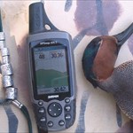
Magellen Sportrak Map display resolution is 160 x 104 which is 16,640 pixels on a 2.3" x 1.4" display or 3.22 sq. inch display. This equates to a resolution of 5,168 pixels per square inch. Garmin's Vista is 288 x 160 which is 46,080 pixels on a 2.1" x 1.1" display making the display resolution 19,948 pixels per square inch on a 2.31 sq. inch display. Display quailty - No Comparison Garmin wins hands down. The display size of the Garmin, however, may be an issue for some. -
GARMIN LEGEND FIRMWARE UPDATE.
Rubberhead replied to shabbasuraj's topic in GPS technology and devices
I know four people from Sweden. Three of them are named "Anders". -
GARMIN LEGEND FIRMWARE UPDATE.
Rubberhead replied to shabbasuraj's topic in GPS technology and devices
I've had a eTrex Mariner now a Legend. I always upgrade, mostly because I'm a geek and geeks always upgrade when we have a chance. I do keep the previous versions on my computer in case I don't like the upgrade, but, so far, that's never happened. I don't think previous software versions are available on Garmin's website. -
Readymixer, You might was well ask if you should date blondes or redheads. It's a personal decision. If you pick wrong the first time, you're only out a few dollars. Thank goodness for ebay.com. I have a friend that always says the following formula for happiness: Date Blondes, Marry Brunettes, Fool-around with Redheads. I think this only works if the Burnette in line 2 doesn't own a gun.
-
The POI Database that comes pre-installed on the Legend has marine navigational aids. Unless you are on the water near saltwater, you probably won't even miss it.
-
Upgrade from a Mariner to a Legend
Rubberhead replied to Rubberhead's topic in GPS technology and devices
I've played with the map settings but can not seem to get it to work any different. Here's the issue. The Topo maps have their own set of Points of Interest that overlay the actual road and terrain maps. Adjusting the map setup affects the Topo's POI and the stand-alone POIs the same. However the Topo's POI are still taking precedence over the stand-alone POIs. I have been using two red bouys in South Carolina's Charleston Harbor to test with. One of these red bouys is in a slightly different location on the Topo POI database than in the POI database. The other red bouy does not exist in the Topo POI dbase, but does exist in the stand alone dbase. With the points of interest autozoom set to 0.8 miles, the Topo POI displays at a zoom level of 0.8 miles while the POI data only displays at a zoom level of 500 feet! With the points of interest autozoom set to "auto" the Topo POI displays at 1.2 miles, while the stand-alone POI displays, again, at 500 feet. Is there something I'm missing? -
With the $50 rebate and cheap prices on ebay.com, I couldn’t stand it any longer so I upgraded from an eTrex Mariner to an eTrex Legend. I also got Mapsource Topo to go along with the Points-Of-Interest that I already had for the Mariner. Here are a few observations comparing the Mariner/Venture with the Legend: 1) It’s harder to follow a land-based track or route on the Legend because the map already has a line on it. This is not a problem on the water or off-road. 2) Loading the Business Listings from the POI over the Topo Maps works well because the businesses don’t show up until zoomed in usually around 800ft or less. This keeps the map from getting too cluttered. However, the marine points on the Topo take precedence over the POI marine database which is not good since the Marine POI database is newer and has more information and points. 3) 1 Megabyte is not enough in the Mariner/Venture. I was always loading and re-loading POI information. 4) 8 Megabytes in the Legend seems to be plenty for a day-trip that includes outdoor activities. 5) It’s silly, but the white case on the Mariner makes the unit look more classy and professional than the Nintendo-like case of the Legend. 6) Both units are unbelievable bargins considering that either one can now be purchased for around $200 or less. If they would just add tidal preditions to either, these units would be unbeatable. Note: I have only geocached a few times. Mostly I boat inshore and offshore and hunt.
-
I did what SergJax said and it worked like a champ. Alphawolf, Copy the entire content of the first disk to the mapsource directory. If you did a standard installation it should be under c:program filesmapsource Once you've copied all these files, remove the CD and run c:program filesmapsourcesetup.exe If you have other CDs in the series, you simply copy the folder and its contents to the mapsource directory.
-
Why didn't I think of that?
-
I have copied the East and West folders of Mapsource Topo to the Mapsource Directory but Mapsource still wants to read information from the CD. Is there a setting where Mapsource will get information from the harddrive instead of the CD ROM?
-
The Venturer does not store maps - it stores points. The Venturer (or Mariner) is great for offshore navigation because a marker buoy is simply a point on a two-dimensional surface. For terrestrial navigation you probably want a unit that can hold a map like a Legend, GPSMAP76, etc.