


68-eldo
-
Posts
355 -
Joined
-
Last visited
Posts posted by 68-eldo
-
-
It wouldn't have anything to do with a spur, just roads. and would not be likely to have been left in place if a grade crossing was replaced with a bridge. I looked at Google and didn't see anything looking like a grade crossing either. Maybe it was put there as a historic piece. It is a mystery to me!
Now that I think about it the whistle post for grade crossings that I’ve seen were marked with WX. This one is marked with only the W. Could it be for a different signal?
-
I'm guessing this post I found right next to the commuter rail station in North Billerica is a similar right of way marker. There was also one on an abandoned spur nearby.
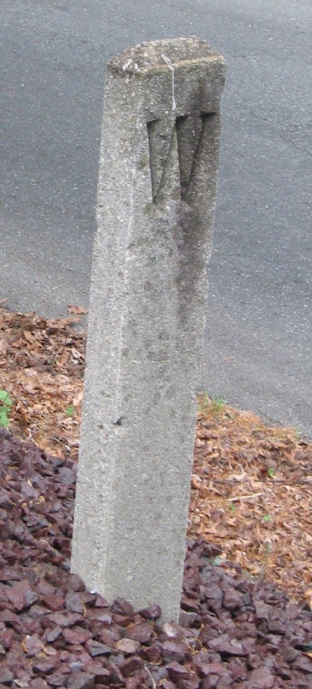
I have to disagree. That looks like a whistle sign. They were placed near a grade crossing to tell the engineer to blow the crossing signal with the whistle.
-
(This was posted on the NGS Forum as well.)
Ok, I am really confused. I recently found two disks AX0798 and AX0797 (photos are included at these links). The datasheets say they were both monumented in 1966 but both disks are stamped 1943 and the culverts they were both on look old enough to be 1943. I can not find anything on the NGS site for these two disks. Can anyone help? I don't know what else to do with these to identify exactly what I found. The links to their datasheets are: AX0797 and AX0798 .
Barry Watson
My guess is they were placed by the Coast and Geodetic Survey in 1943, then they were surveyed to NGS standards and added to the data base in 1966.
Others with more experience will add their comments, I am sure.
-
That brings up the question of the painted BM on the road, which implies that a surveyor used it for some purpose. Either the reset mark is listed with an agency that is not the NGS (states and counties often have their own marks that don't get into the NGS database, but we have already ruled out the county from what was said here), or the reset has been used as if it was the original mark, which would be a mistake. This isn't the first time I have seen that sort of thing, but it makes me wonder what effort some of the survey crews put into finding these marks.
I found AB6521, broken and upside down, yet painted pink, with a notation on the road beside it. This mark was a first order horizontal control mark, so no matter where it was "replaced" after whatever accident broke it off, the accuracy was completely compromised. And that assumes that it was replaced exactly where it was broken. I saw no evidence of the remainder of the base. The mark is unusable and has been declared destroyed.
Maybe the survey crew uses a go-fer to find the marks so that the highly paid professionals are not wasting time tramping around in the weeds. The go-fer found and dutifully marked it. Just a guess.
-
I can’t answer your question, but I can offer this tidbit of information.
When we did battery alignment on the ships to align the guns, directors, and other parts of the weapons system we do it by sighting on a star to eliminate parallax. Obviously this has to be done during darkness. But it is always done during the early morning hours because we had to wait until the temperature of the ship evened out. The sun shining on one side of the ship warps the ship enough to make the readings of little value if done too soon after sunset. Not to mention the readings would change as the ship cooled off.
With that in mind one would have to wonder about stations like this one. As the sun shines on one side of the building I would think the mark would move because of expansion of the sunny side of the building. So how can this be a first order mark? And of course the height of this mark must change too, but it is scaled so its height is not accurate.
<babble=off>
-
Unfortunately the major impetus to convert the files is that they take up too much room. Can you imagine how many file cabinets are needed to hold all the data sheets?
The earliest technology to reduce this kind of paperwork was microfilm. While that medium was good it was rendered nearly useless in some cases by giving the work to the lowest employee on the totem pole. That employee was then rated by quantity not quality. So a simple thing like checking the focus of the camera was neglected. Then the bureaucrat asks why do we need the paper when we have it on microfilm? So the paper was thrown away and the file room was converted into the office of the Vice President for Contemplating Navels.
I have found most microfilm to be nearly useless. An example: A number of years ago my aunt showed me a genealogy chart created by a Mr. Von Beck Canfield in 1912. The chart took that branch of our family tree back to 1200s in some cases. She allowed me to take it to work to copy off on the copy machine. It did not work that well and not all parts of the chart are readable as my aunt’s copy was barely readable. The original chart was kept in the New York Public Library. So I sent a request to them and they sent me a microfilm reproduction of the chart. It is not as readable as the copies I made. Unless I can follow in Von Beck’s footsteps and see the original documents he saw (not the microfilms) that part of my family tree maybe lost.
Sorry for the rant.
-
WOW, that’s a nice display. A lot of interesting things in there.
Is that an HP 85 calculator? Does it still work?
-
In my area NGS seems to be correcting the lat/lon of the scaled marks. But they don't seem to be using the logs.
One of my first recoveries is TU0450. If you look at the GC.com data page which is frozen in time, the coordinates are N 21° 20.833 W 157° 57.700.
The latest NGS datasheet the coordinates are N 21 20.850, W 157 57.700. It has moved north about 103 feet but still about 690 feet south of the actual location.
Hand held coordinates are N 21° 20.959 W 157° 57.679 which when plotted on Google Earth is about 50 feet west of the actual location. Considering the mark is on the north face of the building those coordinates are probably the best you can get with the wall of the building blocking the signal.
TU0626 has also moved about 103 feet north and TU0637 has moved about 99 feet. So there is some corrections being made, but I don’t know how or why. While the corrections are an improvement they are still a long way off, and not always in the same direction.
Still need to use the directions to find these marks.
-
I wonder if the NPS sells confiscated metal detectors.

Just a guess but I would think anything like that would go to government surplus for sale.
The non profit I volunteer for has access to state surplus and we picked up a large box of scissors for a few bucks that was confiscated at the airport.
-
These are "in my county" but I don't think I will be getting them any time soon.
DE5195 NECKER AZ MK
DE5202 PEARL ASTRO 1959
DE5228 GARDNER
DE5231 LAYS
DE5246 UHPGF POLE TERN 1
DE5247 KURE 2001
DE5248 LISIANSKI 2001
DE5249 NIHOA 2001
Also not in the GC database. But the NGS data sheets have links to photos.
Try plotting these in Google Earth or Google Maps.
-
I also did the NGS download - BMGPX - Google Earth thing and it makes a big difference when looking for benchmarks.
But I did not like the choice of icons Google Earth had so I went to custom icon and changed it to this URL http://www.geocaching.com/mark/images/WptTypes/27.gif.
That gives you this for an icon.

-
How do you key in the degree symbol for google maps? I tried copyng and pasting the degree symbols from MS Word and WordPerfect, but Google Maps doesn't recognize them. I copied and pasted it from the first post on this thread and saved it in a MS Word file, but it's awkward having to open it up every time I want to check a coordinate on Google Maps.
You don't need the degree mark. Say you want to go to N 44° 58.035 W 103° 46.293.
You can type in N 44 58.035, W 103 46.293 or N 44 58 02.10, W 103 46 17.58 or 44.967250,-103.771550. All of those will take you to the same location on Google Maps. Just be sure to use north and west indicators.
-
Added note, for Utah you can go to this web site for more information. If you click on the link near the bottom of the page you can search for Plats. When I did that I found the 1856 field notes for T9S R2W. Pretty cool.
-
As Z15 said this is a corner marker between sections of land. It’s in Township 9 south (T9S) and on the line between Range 2 west (R2W) and 1 west (R1W). It marks the corner of sections 13 and 24 of Range 2W and 18 and 19 of Range 1 W.
I went to this web site and found the coordinates for the center of section 24 to be 40.021833,-112.013500
Plug that into Google Maps and see if that does not come close to where you found the marker.
-
Ikane
Thanks for posting that link. And thanks to your company for putting the information on the web site. That will be very helpful to a lot of people in that area. It was also helpful to me even though I am many miles away. I down loaded the NY file and saw there were many stations near or on old Coast Artillery Batteries (another interest of mine) and with the descriptions of the stations I was able to confirm some of the locations of the batteries that I found and marked with Google Earth.
It was also fun looking at some of the recoveries. I noticed along Shore Drive Papa-Bear-NY (GEOCACHING (RG)) made a number of recoveries but also skipped a few. I wonder if he saw the marks on Google Earth if he might have found them.
I down loaded the county listing for my county and put that on Google Earth. It makes a big difference when looking for benchmarks.
-
Like many folks here, I maintain my own web site. In my case, it's mostly hiking and mountain climbing reports with a little running stuff thrown in.
I'd like to add a section on my Benchmarking, but clearly what works for a hiking report - typically a long narative with pictures sprinkled in - will not be ideal for Benchmarking. But I'd like to use the superstructure I've already built to "frame" the benchmarking stuff.
FYI, here's my home page: Home page.
I have some ideas which have not yet gelled into a format. These include:
> Index by county with perhaps a table of links to visited marks. Maybe thumbnails as well
> Link my GC logs. No need to recreate a format when GC has a reasonable one. Perhaps throw my GC logs into a frame.
> perhaps use Google Maps and put all my finds for a given county on a map. Looks like I'll have to learn the Google Map API.
I woukld love to hear what others have done, or would like to do. If you have a page already working, by all means post a link. If you have any ideas, implemented or not, throw them out there.
Thanks
Papa Bear
That kind of reminds me of a local hiker/chacher. He likes to post reports of his hikes too. His web pages are not as nice as yours but he adds a topo map with a GPS track on it. Here's a link to one of his pages. He does not have an index page. Don't miss the "next" link at the bottom of his page. It is somtimes hard to see.
That doesn't help you much with your benchmark page.
Very nice web page Papa Bear.
-
In fact, at it's most simple level, that is how the GPS system works, measuring differences in received time from the various GPS sats. I believe that one of the given constants that the system uses in the calculations is the speed of light (radio waves), including the speeds through the various media (vacuum, air of various densities, etc).
So really, these "speed of light" experiments formed some of the basis on which the GPS system is based (among many other things).
Full circle, huh?
Radar is also very dependent on the speed of light. The time it takes for the transmitted pulse to get to the target and the echo to return divided in half is then multiplied by the speed of light to determine the distance to the target.
Conversely if the distance to the target is known precisely, then the speed of light can be determined from the time it takes for the echo to return to the antenna.
-
Ah Wikipedia is great. It says the first experiments were done in 1667 using lanterns about a mile apart. It does not go into detail as to how the experiments were done, but I would imagine the reaction time of the people operating the lights would render the results useless. But then this experiment may have been more about finding out if the speed of light is finite or infinite then finding the actual speed.
The first quantitative measurement was done in 1676 by Ole Rømer observing the appearance or disappearance of the moon Io as it orbited Jupiter. The appearance/disappearance would happen later than predicted as the Earth moved away from Jupiter and sooner as the Earth moved closer.
With modern radar and lasers such measurements are much easier.
Sorry about the topic migration.
-
I do not know that much about either one.
I can't even remember where that article I have is about when they changed the speed of light to it's new definition to more correctly fit some model designed by. uhhh.
edit:
Oh yeah it was the metre thingy.....
Since the fundamental SI unit of length, the metre, has been defined since October 21, 1983 in terms of the speed of light; one metre is the distance light travels in a vacuum in 1/299,792,458 of a second. Converted to imperial units, the speed of light is approximately 186,282.397 miles per second, or 670,616,629.384 miles per hour, or almost one foot per nanosecond.
I can not even comprehend that.
my eyes just aint that good anymore.
I would really like to meet the guy who had his thumb on the stop watch button.

Seriously how did they measure the speed of light? It’s something I’ve pondered for a long time. It’s not like they could set up with a light on one mountain top and an observer on another one with radios to communicate.
-
Great pictures. The line extensions (Great circle around the word, and Rhumb line spirals in to the pole) make it even clearer.
-
In most of the fora, the response would be "Don't Feed the Troll".

Yeah, I thought about responding to the O.P. too, but it reminded me too much of a guy in the shop that would make statements to individuals just to "wind them up". It was a sport with him. After a while you just learned to ignore him and he went on his way to find another victim.
He was about as sad a character as the "if it doesn't count I won't do it" bunch.
I agree, don't feed the troll.
-
Hey - you should've gotten to know him...he'd come in quite handy when you look for EX0170 ..watch out for the shoals, tho'!
The extreme North and extreme West benchmark for my county is DE5247 located at 28°23'37.52"N 178°17'38.14"W. It's not on the GC.com database. It doesn't even show up on the Google maps. Google Earth shows the location. That’s going to take more than a small boat to find. That’s 1558 miles from my house. It might be awhile before I go after that one.
-
Tom said he doesn't remember you. He was the one in the white hat though, so he wasn't surprised you remembered him.
Yeah! Tom! Wore the white hat and blue chambray shirt. Pants with the button fly and square patch pockets. He was one of the good guys. We knew that because only the good guys wear white hats.

Glen FTG2
1964 - 1968
-
The last sentence in the description for NA1886 says the mark is above the level of the highway. It’s hard to tell from the overall view if the hole in question is above or not, but normally that part of the bridge is not. If it is lower than the highway then it might be a good idea to make another search for the mark.


I know it's not a benchmark...
in Benchmarking
Posted
You learn something every day.
Thanks