


68-eldo
-
Posts
355 -
Joined
-
Last visited
Posts posted by 68-eldo
-
-
Another great expedition and an equally great report.
Thank you for sharing.
-
Heh, I wonder how far out to sea Hawaii's would be.
It’s about 13.8 miles SW of Makapuu Light house and 14.2 miles WNW of the southwest point of Molokai.
Coordinates are here 21 8 48.36 N 157 31 28.03 W
I took a guess and was off by about 14.5 miles.
-
Excellent work Papa-Bear. You set a very high standard.
-
I just got off the phone with Mr. Doyle (DaveD) with the NGS.
The word is getting out and all of the State Geodetic Advisors are aware of the new GEOCAC project.
We also spoke of how this is a great way to educate those who may not be aware of all the technical issues that go into Mapping and how our GPS really works.
If you are in another country besides the US and would also like to get involved e-mail me through my profile.
There are some pilot projects that may be used in helping us in other Nations and Countries.
I am working on the writeup to make this a little easier for those who have already shown interest and will get it out ASAP.
I just wanted to clear up some trivial things that are also part of the project.
Thank you all once again for your continued support of this project and look forward to working with all of you.
OK, so I would like to help out with this, but if I call the state advisor I am not sure what to say. Is this something NGS is pushing or would that be my job to “push”?
I eagerly await your write up so I know what is involved and what my role in this would be.
-
-
-
In my area there are “street monuments”. These are there to help define the right of way. I find these monuments at each intersection and the start/end of any curve in the road. They are under a metal cover about 6 inches in diameter with a label on the top. I think they mark the center of the right of way. I’ve seen surveyors use these as a starting point when surveying property boundaries.
If you can find one of those in the street that would be an ideal reference point.
Just a suggestion.
-
Maybe Deb Brown is messing with you Holograph :-)
-
Have you considered This option?
Hmm, I wonder whether putting a light bar and a magnetic sign on a 944 would be convincing? I suppose not...

Hey, does anyone have suggestions for what to look for in a safety vest? Just something orange with a couple of pockets?
Patty
About as convincing as a light bar on a ’68 Eldorado.

I use a light vest, orange with yellow reflective bands. It was cheap and does not take up much room in the truck. But I see the latest “fashion” for roadside workers is the full length jumper with long sleeves, orange with lots of yellow reflective stripes. This is in the tropics. I think they are going for protection from the sun.
I got my vest from a welding supply store, but when I was in the surveyor supply store I saw several types. There was orange with yellow reflective stripes, florescent green with reflective stripes both with and without pockets.
I think I’ll get my next one from the surveyor supply store.
-
These stations pose a problem for me. They are all in the county of Honolulu which I have been working on. The last couple of years I have had personal business to tend to so I have not been able to do much bench mark hunting.
But when I get free, my nephew is a boat captain and makes trips to the northwest islands on occasion. Maybe….
As to Klemmer’s question about TT6243, the international date line zigzags back and forth so that certain lands stay in the same date as the rest of the country. Alaska is one place the date line zags west. I’m guessing that they also extend the longitude beyond 180 degrees also so that the marks stay in the same hemisphere.
I presume CallawayMT will be logging those marks with NGS? Glad to see some progress on the outer islands.
-
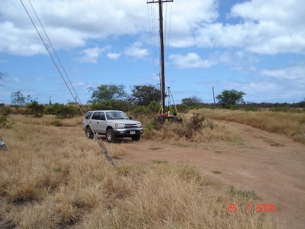
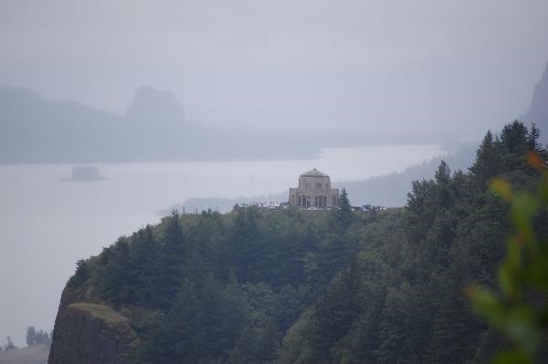
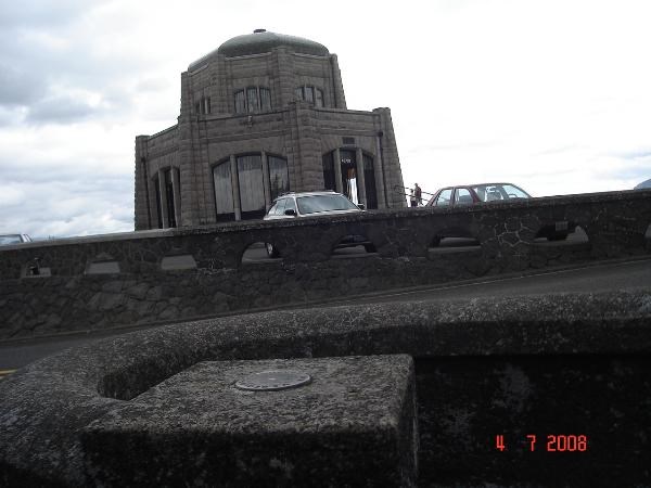
I knew I had this picture someplace. It's Gilbert occupied
-
If you look at my recovery of Gilbert there are pictures of the “tablet” under the signal pole. It is at or near ground level and the cross bar above the tablet is to prevent the post of the signal from contacting the mark. With the pole removed the surveyor can drop his plumb-bob down to the mark while the platform provides a location for the tripod.
The signal on this one is gone for some reason. This location has been out in the middle of a cane field for many years. Now “civilization” is moving in on it.
-
i seem to remember a number around 4,490 miles mdg2003 but i can't remember where orwhen i saw it.
the platform is similar but of different proportions 68-eldo. it was set into a pedestal of pier-like construction. there is a post with a target marker and some evidence of some minor disturbance to the site. i didn't think of (re)moving the post but then again i didn't know what i was looking for. in retrospect i would still refrain from doing so should i encounter a similar situation to this one.
btw wintertime... here's how we got there. notice the spot on their map?
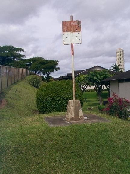
This one is a reconstructed “platform”. Because of all the construction in the area this one has been renovated. But the signal remanins the same.
-
This picture is of a type a Hawaii Territory Survey Triangulation Station Monument. Did the platform look like that? Sorry I could not find a better picture.
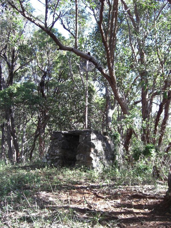
The mark is usually directly below the pole in the center and difficult to photograph. This is designed to allow a surveyor to remove the pole and occupy the mark. You can sometimes photograph the disk that way.
-
I’m sure most of you know there are different types of mowers. For home use there is the reel type and the rotary, but along the highways flail mowers are frequently used. These have small blades attached to a shaft with a short piece of chain. As the shaft rotates the blades straighten out the chain and cut the vegetation. If it hits something hard like a rock (or benchmark) the blade will bounce off with little shock to the shaft. It’s possible the dents on NA2218 could be caused by a flail mower.
-
Can you give us a step by step description on how you accomplished this? It would help us to work with the other states.
-
I suppose that it's remotely possible that an agency or firm doing a station setting project, in which bluebooking would be involved, could be somehow motivated to name a station GEOCAC somewhere.
Hey, uh, DaveD, Christmas is coming up soon, hint, hint...

So, anybody here know how Fort Nonsense got its name?
Patty
Good old Google.
-
Thanks for the help. I now have a better understanding of the shorthand used to describe the plot of land.
CallawayMT’s drawing made it “click” in my head. Thanks again.
Sorry for the thread drift.
-
That is 226 miles approximately East of the Initial Point for Idaho.
It appears to be the 1/2 mile mark or 1/2 of Sections 25 and 36.
Which is also within the First 6 miles North.
So I venture to guess it is in
T 1 N, R 37 E, S's 25-36
Or written out Township 1 North, Range 37 East, Sections 25-36.
Just a quick guess.
Maybe I should have explained the math of the PLSS.
Each Township is a 6x6 mile square as can be due to the convergence of the Meridians at the Poles.
Beginning at the Initial Point 0.
Each Township is divided into 36 Sections each Section a 1 mile square.
The NS designation begins at 0 or the Initial Point.
Thus Township 1 N is the End of the 1st 6 miles,TWP 2 NX6=12 miles,3 NX6=18 miles,4 N,etc.
The same holds true for South directions.
Beginning at the Initial Point 0.
The EW designation is divided the same way but called Ranges
So merely taking the distance from the Initial Point and dividing by 6 you come up with the Range Line.
Same with the Township.
The Sections further subdivide the Township.
This is a brief explanation it gets deeper fast.
Is there someplace that has a tutorial on the PLSS? I’ve got the basics of township, range and sections, but where you start to divide up the sections, that’s where I get lost.
I’m particularly interested in this description:
T7N R94W S34 E/2SW,SWNE,W/2SE,SESE S35 W/2SW
I know that this is township 7 north and range 94 west section 34. After that I am lost.
I found the Lat. Lon. for the center of section 34 by using the calculator at
http://www.esg.montana.edu/gl/trs-data.html
This is from the Sixth Principal Meridian.
Any help would be appreciated.
Thanks
-
According to a public service announcement I recently saw on TV, its a (Federal?) crime to Trespass on a RR and that the RR's are going to prosecute anyone who does. It endangers you, the public and the RR employee's if they have to take evasive actions because of your presence. You make be suspected of criminal intent and treated accordingly.
Yes and no. It's a federal crime to interfere with any railroad. Whether a railroad reports you or not is up to the railroad. (My railroad, for example, won't just report anyone walking along the tracks. If they're seen obviously doing something they shouldn't - destroying a signal, digging around a bridge, etc.) Then yeah, they'll get reported.
All railroad property is private property (with few exceptions), so on top of criminal, they could go after you civilly, too.
So what would be the correct way to go after benchmarks along RR property? If a surveyor wanted to use those marks I assume the RR would have a procedure to allow them to do that.
The shipyard I worked for had a video that was shown to all contractor personnel before they were allowed into the yard. It covered safety, security and a few other things. If we were to present ourselves to the proper RR authority and request permission I would think that we could be briefed in a similar manner. We could give our cell phone number to the dispatcher and get his number too. We could call the dispatcher just before we entered the property and again when we are clear.
-
My benchmark hunting vehicle is an ’83 Chevy S10 pickup. I’d take a picture of it but it might break the camera. It’s ugly but it does the job well. Best of all I can drive around in the bushes and not worry about the paint (what paint?).
Note to mloser: You most likly have a conector problem and maybe a motor mount problem. A few years ago I started my ’68 Eldorado, when I blipped the throttle the engine reved up, cut out, reved up again, cut out again repeating the cycle as long as I held the throttle open. The all the lights flashed on and off while this was happening too. On investigation I found the main power connector was loose. It is about one foot from the starter. When the engine reved up it moved slightly in the engine compartment from the torque. This movement was enough to break the connection and kill all power to the car including the ignition. When the ignition died the engine would settle back into its normal position which reconnected the connector. Ignition restored; engine reved up; connection broke and the cycle repeated its self.
Your problem while not as extreme as mine was, is likely similar.
-
The coordinates are in the US and copied down from the etrex GPSr. They are on the border near Del Rio, Tx, from the locations of the two disks you can see the Rio Grande and into Mexico.
The coordinates for Del Rio Texas is N 29 21.974, W 100 53.891
Which is 621.912 mi (using GeoCalc) almost due north of the coordinates you provided.
I think you meant 29 degrees North vice 20 degrees. Sometimes when I get in a rush my 9s look like 0s.
-
It is my opinion that our group should not attempt to remove paint.
I find this something of a contradiction to many earlier threads. If you are not able to read the stamping on the disk how can you say for sure that you found it? Obviously if the paint is thin enough you can make out the stamping then you don’t need to remove the paint. Also if the disk is on the side of a building you need to get the owners permission. If the owner says no and you can not read the stamping then can you claim the find? I would think when reporting to NGS you need to be able to read the stamping. Otherwise you would have to say you may have found it but the paint was too thick to verify.
As for the paint protecting the disk, I’m sure it does help, but the made them out of bronze so the disk would last a long time with little deterioration. With the exception of disk placed where the ocean waves sometimes hit them I have seen little deterioration of the disk I’ve recovered.
-
OK now for the Grand Finale of the Weekend Expedition,for previous discussion look in the Poker Run Logging thread.
As stated I made it through all the tests the Officer had for me.
Now comes the hard part..................empty your pockets!!
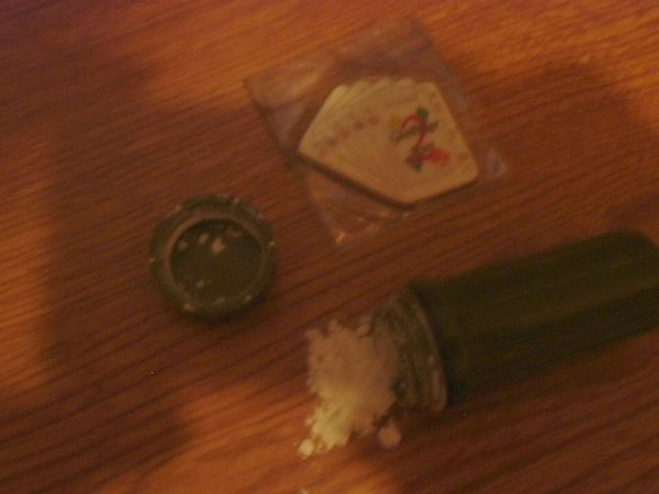
Now see if you can explain this in terms an Officer of the Law and His drug sniffing dog will believe.
Now you have to be convincing.
Cornstarch YEAH RightO!
Actually I think the drug sniffing dog was your salvation. Without the dog signaling the presence of drugs the officer was more likely to believe you.


Benchmark Hunting Tools
in Benchmarking
Posted
With that kind of recovery you should also have traffic cones, maybe a truck with flashing lights and a person directing traffic.
Be safe.