


68-eldo
-
Posts
355 -
Joined
-
Last visited
Posts posted by 68-eldo
-
-
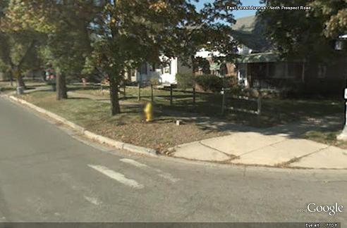
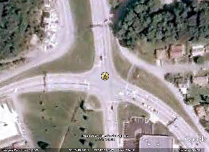
Is that it just to the right of the fire hydrant?
-
Do a Google search for How to build a metal detector
There are a number of web sites that have instructions to do that for example http://www.easytreasure.co.uk/bfo.htm
Most of these will work at a depth about equal to the diameter of the coil.
My father had one with two coils, one on each end of an eight foot pole that worked to a much greater depth. It would be nice to build one like that that would find benchmarks at a depth of about two or three feet.
-
I’ll have to watch it online. I started watching and then I blinked and it was over!!!

Rackafratz
-
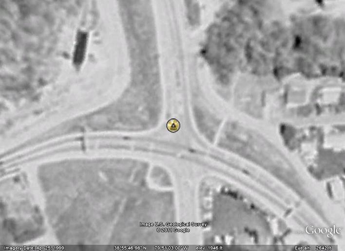
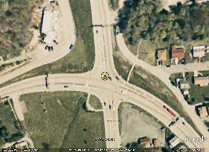
I think Google Earth has a neat feature that's called back in time or something (Google Earth is on another computer I can't get to at this time). It lets you load older imagery up to maybe 10 years ago. If you could find your bridge on an older shot you may be able to enter the coordinates to pinpoint on the shot where the marker should be.
You are correct, and it is available on the tool bar. The icon is a clock. However it is limited to what ever images that is available. The area for the mark in question has four images, 1999, 2003, 2007, and 2009.
1999
2003
2007
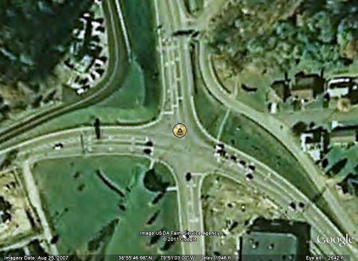
2009
No railroad bridge seen in any of those pictures.
-
My bet is on California. I only searched US states not other places such as Guam etc.
Only two came up with a stamping of 1955, DC0525 and GL0686. Nether one has been recovered recently.
DH0409_STAMPING: J 281 1949
DV1186_STAMPING: J 281 1948
DC0525_STAMPING: J 281 1955
KL0101_STAMPING: J 281 1951
AR0204_STAMPING: J 281 1966
CL0562_STAMPING: J 281 1962
TO0185_STAMPING: J 281 1942
JA0777_STAMPING: J 281 1949
>KE0217 J 281 39 08 29. /094 36 12. 226. 1 XX
>KE0217 J 281 39 08 29. /094 36 12. 226. 1 NN
KE0217_STAMPING: J 281 1948
KE1743_STAMPING: J 281 RESET 1984
GY2712_STAMPING: J 281 1952
GY2713_STAMPING: J 281 RESET 1957 898.789
>AT0158 J 281 29 00 22. /089 20 45. 1. 3 S
>AT0159 J 281 USE RESET 1976 29 00 12. /089 20 50. 4. 3 S
SJ1551_STAMPING: J 281 1948
JD0503_STAMPING: J 281 1962
TK0199_STAMPING: J 281 1935
ML0419_STAMPING: J 281 1949
GL0686_STAMPING: J 281 1955
NA0429_STAMPING: J-281 1942
TG0214_STAMPING: J 281 1963
>KY1830 J 281 40 55 51. /081 45 47. 301. 2 XX
>KY1830 J 281 40 55 51. /081 45 47. 301. 2 NN
KY1830_STAMPING: J 281 1959
KY1831_STAMPING: J 281 RESET 1970
LY1602_STAMPING: J 281 1961
DO0275_STAMPING: J 281 1934
FX0899_STAMPING: J 281 1942
TP0110_STAMPING: J 281 1946
HW2029_STAMPING: J 281 1962
-
Street view on Google Earth verifies there are no bridge abutments there.
But then I get to snooping around and I find the Elkins station and what looks like the remains of a large roundhouse.
Then I see the bridge south of there is missing in 1999 and 2003, but back in 2007 and 2009. Curious.
I know off topic. Sorry. Google Earth leads me astray all the time. <sigh>
-
Thanks Patty.
-
I thought I saw them in the NGS site too, but I don’t see them now.
Must have been a mistake that was corrected later.
-
Something odd about JB1913 the 1970 COP. It has recoveries from 1930 and 1937.
-
Oops mistake, disregard.
-
I’ve added a link to Gmap4 to my Benchmark links page.
-
Planet Eldorado is an excellent place to view datasheets--you can choose from the NGS site or Geocaching.
Thanks for the plug for my web page. I’m glad you like it.
Not to hijack this thread but if anybody has additional links to add to the page or suggestions on how to make it better email me via my profile.
Now back to your regularly scheduled discussion
-
I did a Google search (Thomas freeman surveyor) and came up with a lot of information on him. You might have to do some digging to find the information you want.
Hope this helps
-
My first real job was Fire Control Technician (Gunnery) for the Navy. So I am not at all surprised that the locations of the fire control towers and gun batteries were very precisely surveyed as this had a lot to do with the accuracy of guns. The actual Lat/Lon was immaterial, the distance and bearings (azimuths) between the various components was the information needed to compute parallax, both vertical and horizontal. Without parallax your guns will always miss the target by the distance between the fire control tower and the battery.
-
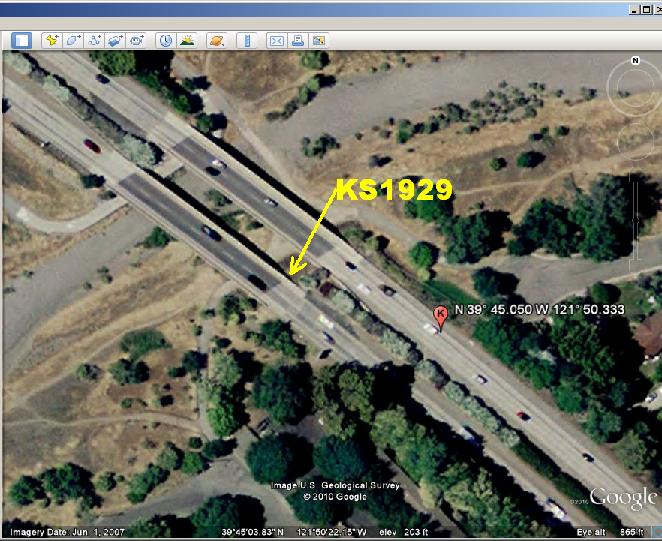
I used Google Earth not Google Maps.
Here is an aerial shot of the area. The arrow points to the location of where I think the disc is. The other marker is where Google Earth says the coordinates are.
http://www.planeteldorado.com/bmdata/KS1929a.JPG
this is a scaled mark so the coordinates could be that far off.
I also searched the north bound bridge until I read the description for about the fifth time.
It looks like you can get into the left lane of the south bound lane and pull off just past the bridge, then walk back to the mark. But be careful, the situation maybe different from what it looks like on the computer.
-
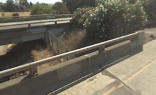
If I was to guess I would say it is marked by the white paint on the guardrail in this photo.
http://www.planeteldorado.com/bmdata/KS1929.JPG
Thanks to Google Earth Street View.
-
It would be great if someone could publish the safety procedures that people that work along the highways are required to follow.
Those safety procedures are there to protect them and if we amateurs used them they could protect us too.
The police will stop and tell you to leave if they think you are a danger to yourself and/or other users of the highways. And they know the safety rules.
To respond to Duke’s post: If you are uncomfortable with it don’t do it. When you get it all figured out how to do this with reasonable safety you will feel more comfortable.
-
My Garmin III+ from 1998 - 2002 can be set to hddd.ddddd; hddd mm.mmm; hdd mm ss.s and 12 other options including British Grid; Loran; USER/UTM and UTM. I leave it on hdd mm ss.s and I use an old version of GCALC to convert to other formats as needed. It’s pretty easy.
IMHO If you are going to submit to NGS you should go by their rules/conventions.
Not knowing that much about surveying, maybe there is an industry standard and to submit in a non standard format is problematic. Just saying.
-
Having spent many hours on the bridge of a Navy ship I can tell you there are too many things wrong with that story to be true. It does make a funny joke.
-
IIRC there was a discussion about this. The idea was to report a not found with a description of what was done to find it or the reason you believe it was destroyed. Then ask Deb to mark it destroyed. That way there is a record of why it was marked destroyed.
-
This is interesting. I took the coordinates 33 24 19.86 (N) 086 52 27.27 (W) and plugged that into Google Earth. It pointed to a location in Troy Michigan. Then I plugged in the coordinates 33 24 19.86 086 52 27.27 GE went to Tibet, which I sort of expected since the longitude is a positive number. But then I plugged in the coordinates 33 24 19.86 -086 52 27.27 (notice the longitude is a negative number) and GE went to Shannon Alabama which according to the data sheet is correct.
So why did the first one go to Michigan?
To respond to hotrod205’s question; be sure to put the minus sign in front of the longitude.
-
It’s interesting that loud sounds like tornados are frequently described as sounding like a fright train coming. And yet fright trains can be very quite.
Just an off the wall observation.
-
I believe it is a pipe valve stem. The handle padlocked to the side is used to turn the valve on or off. It maybe related to a fire hydrant which would explain its red paint.
If I am wrong someone will correct me.

-
I started to look up all those points in Google Earth. #1 is a railroad crossing that seems to cross at an angle, but the map shows it perpendicular. #2 & #3 are a park that I can not see even in street view. #4 is a concrete culvert for an un-named stream I could not find.
However Google Earth Community shows a “Rainbow Bridge” in that same area but is not on the maps.
It may take more than I am willing to do right now.

Michigan Benchmark - not in database
in Benchmarking
Posted · Edited by 68-eldo
To put it in a nutshell; you must post your picture somewhere else, you can not upload a picture to this site. Any web site will work. If you have a Picasa Web account you can post the picture there. One of the popular ways to post a picture is to add the picture to one of your Geocaching logs. The picture I posted is on my personal web site.
Once you have posted the picture then copy the URL (http://umptedump.com/any.jpg) and paste it into the text of your post here. With the URL highlighted click on the Insert image button above the text box. It will put the proper image tags around the URL.
HTH (Hope that helps.)