


snowfreak37
-
Posts
85 -
Joined
-
Last visited
Posts posted by snowfreak37
-
-
Sounds like you're getting pretty close. The guardrails and telephone poles could have changed considerably in 36 years, but between the 0.8 mile from Cannon Corners and the elevation of 622', I'm guessing it's no more than 140' NE of GZ. Does the rock outcrop extend that far?
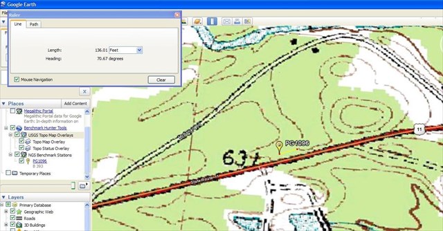
The rock outcrop is fairly narrow say around 50ft east to west, but it extends to the north around 100ft which would put it well beyond the 54.2 feet from the middle of the road. I combed over that enitre area at least 3 different times with no results. I was hoping there would be some indication where that old telephone pole was. A hole in the ground, a left over pile of stones, part of the pole still in the ground but I couldn't find anything that was of any help.
-
Have you taken a look at McDonald Rd, just in case the highway was moved? (See Holtie's and my earlier posts)
I have not checked on McDonald Road. There are no guardrails on McDonald Road currently and there isn't a spot where the road is 7' higher than the surrounding land. It can't hurt to check though. The area I have been checking matches the landmarks listed on the datasheet. There's guardrails, the road is at least 7' higher, and there is a pretty good sized rock outcrop. I realize the coordinates are scaled but the GPS'r reads around 50ft at GZ if I follow the datasheet directions instead of the listed coordinates. I'll take a spin down McDonald Road and at least check the area. I have someone I can ask to see if McDonald Road used to be Route 11.
-
I returned the metal detector and have given up on this mark.
Hate to see you give up on this mark completely... try it again at a later date, maybe late fall or early spring.
Those 3.5 inch brass disks will make a detector scream, much like a flattened soda can.
A good detector can read them buried a foot below ground level.
~ Mitch ~
When I went back this last time I really over estimated the amount of soil on the ground. I think the deepest part was around 3 inches of sand. Much of it was lucky to have an inch of soil. I may very well come back this late fall. There was a bunch of blueberry bushes in the area which made it hard to get close to the ground and keep the metal detector in motion. I really expected to come up with a find. Who knows maybe I'll bump into someone that has an upscale metal detector and try that too.
-
I tried using the metal detector this weekend to find the benchmark. I searched in my backyard first to get a good idea on how to use it. It got to the point where I could (see) the object above ground. I found nails, staples,cans,bottle tops, a large 1"x4' piece of metal that's still in the ground ( I was catching hell from the Mrs from the holes in the ground) but honey its only the back yard. My most exciting find was the key that I lost late this winter and still works like a charm. I didn't find the benchmark. I searched a very large area and came up empty handed. I measured from the existing poles(which have been replaced) 179.2 west which put me well beyond the rock outcrop but still used the metal detector and found nothing. Ironically from my initial search point I measured 179.2 east and one of those 3ft high green cable upright posts was installed. There was also a 4ft section of old telephone pole lying in the vicinity. I really think I'm in the right area just can't find this mark. I returned the metal detector and have given up on this mark. At least I found my lost key so not all was in vain. Even though I came out empty handed I could see where one of these devices would come in very handy for situations like this.
-

This looks like the “stan-helio” anchor points shown in a photo on the last page of this recovery report that this forum post by bullionhunter led me to - how cool is that.
I don't mean to say that this is the same as the one you found but it might explain what it is.
It sure looks like the same type of eyebolt. I could kick myself right in the pants for not looking closer at the area. It's right out in the open and very easy to walk to, unlike the other station mark that is on the summit. It will give me a good excuse to climb another day. Thanks for posting this information.
-
Thanks for all the replys so far. I borrowed my friends metal detector and the markings say Bounty Hunter Pioneer EX. He's trying to find the owners manual but it seems easy to operate. It has 3 depths settings Shallow,Medium, and Deep of course I am not sure what kind of depth they correspond to. The top section has 4 Probable Target options Iron/AL ZN/AL 5 cents/COINS. It will probe for all or you can reject the ones that you want to. I am not sure if I should leave it in the find all mode or reject a few of them. It also says it needs to stay in motion to detect objects. This one seems to make the same noise regardless of how big the object is. Now all I need is some dry weather and some luck to find this benchmark.
Does the manual look like this?
It does now

-
Thanks for all the replys so far. I borrowed my friends metal detector and the markings say Bounty Hunter Pioneer EX. He's trying to find the owners manual but it seems easy to operate. It has 3 depths settings Shallow,Medium, and Deep of course I am not sure what kind of depth they correspond to. The top section has 4 Probable Target options Iron/AL ZN/AL 5 cents/COINS. It will probe for all or you can reject the ones that you want to. I am not sure if I should leave it in the find all mode or reject a few of them. It also says it needs to stay in motion to detect objects. This one seems to make the same noise regardless of how big the object is. Now all I need is some dry weather and some luck to find this benchmark.
-
Unless noted otherwise, distances given in the datasheet description are horizontal, as opposed to slope (cut string), or along-the-ground (measuring wheel) distance. This is achieved by holding the cut string (or measuring tape) level while using a plumb bob to transfer the measured distance down to the ground. The slope distance will always be longer than the horizontal distance. In your case, the 54.2 feet would fall even further north of the centerline than what you measured with the cut string. Does this still put you on a rock outcrop? If not - Could it be on McDonald Road? When was the State Highway moved?
The 54.2 feet even further north would still be on that rock outcrop. The only measurement I have made so far was with my measuring wheel. I was considering cutting a piece of string but do not intend on going that route. Even though the coordinates are scaled I am quite certain its off of Route 11, there are no guard rails whatsoever on McDonald road. I am not sure when the State Highway was moved. At least I have a general area to concentrate on now. Just need to borrow the metal detector and dig in.
-
This benchmark is not really of any importance to me except it's fairly close by and its proving to be more difficult than I thought. The first time out I only had my GPS'r and the datasheet. Even though the location is scaled I was hoping to find this rock outcrop with my eyes only. That didn't work so I walked to the the west end of the north guard rail and walked roughly 149.5 feet to the east(I have around a 3 foot stride) and walk roughly 54.2 feet north from the center of the road. There is a small portion of exposed rock outcrop and I kick away some of the loose dirt and find nada. Today I went out with my handy dandy measuring wheel and went an exact 149.5 (which was within a foot of my rough calculations the first time) and measured an exact 54.2 feet. The other measurement from the telephone pole is obsolete they have been moved since 1973. In fact its quite possible that the guardrail has been lengthened or shortened since 1973. However this is the only rock outcrop for a distance, so I believe I'm in the right area but quite a bit of the rock outcrop is covered with 3-5 inches of soil, grass, brush which leads me to the metal detector question. I can borrow a friends metal detector and it has the ability to detect different metals. What are these benchmarks generally made of? I have never used a metal detector before so I guess I am looking for some input on what to expect. It's got to be better than digging through the dirt.
On a seperate note when I measured from the center of the road I used my measuring wheel and the benchmark is down a fairly steep embankment. If I took a piece of string and cut it 54.2 feet it would put me further north than my measuing wheel. Not sure if the measurment is line of sight (cut string) or how I am doing currently doing it. Thanks for any input.
-
I am new to benchmarking also and appreciate the link to the map. In fact thanks to that map link I will be going out with my Father in Law and hopefully finding a benchmark extremely close to his home that I didn't know was there. Thanks
-
Very pretty. I have never seen that one. Thank you.
I hope you don't mind, I am going to post another of your pictures that you did not post, from the top of Lyon Mountain.
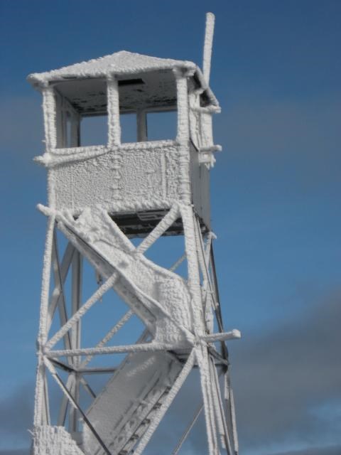
And then you climbed up those Icy steps???

Yes I did climb those icy steps. The wood made an erie sound when I put my weight on them. Needless to say I stradled the sides of the steps where the metal holding brackets are located. I have a mild fear of heights which didn't help any. Come to think of it maybe its not so much a fear of heights but common sense in my middle age years

-
-
From USGS (not NGS) Bulletin No. 122, 1894, p 41.
Note that the initials V.C. are for Verplanck Colvin. Bullionhunter wrote an article about him and the Adirondack Survey on the benchmark wiki.

The coordinates would have been in the New England datum.
Good find Jim and the link on datums is a great help.
Incidentally, the name "Principio", used as a fixed point in the New England datum, was not chosen because it was the "first" or "primary" point, but because it was on the grounds of a local business. Here's an excerpt from the description:
"DESCRIBED BY COAST AND GEODETIC SURVEY 1878
ON THE HIGHEST PART OF A DENSELY WOODED RIDGE, ABOUT 2-1/2 MILES
N 24 DEG W FROM CHARLESTOWN AND 200 YARDS N (MAGNETIC) FROM
CROSSROADS, KNOWN LOCALLY AS FOYS PATCH, ON LAND OWNED (IN 1834)
BY THE PRINCIPIO FURNACE CO., AND ABOUT 1/2 MILE NORTHWESTERLY
FROM THE FURNACE."
But back on topic - to snowfreak37: although the positions in the 1894 USGS report used the old New England datum, the NGS has readjusted the station's coordinates through the years so that the location found in the excerpt of the table quoted above is in the modern datum, and should be more accurate than your GPS can measure.
To be precise, the location of PG2138 is
latitude: 44 deg 42 min 16.55559 sec.
longitude: 073 deg 51 min 47.01563 sec.
And you now know the station is a copper bolt embedded in the rock with the initials VC (and other stuff) presumably carved in the rock.
I would say it's worth another visit to find this. My reading of your photo (although a bit blurry) is it's not a copper bolt. but some kind of bent pin or eye bolt, probably iron. It may well be you found a tie point for the tripod over the station, so you may be very close.
If you do unequivocally find it - a copper bolt complete with initials "VC", you could submit it to the NGS as a FOUND, together with a complete quote of the 1894 USGS report (and give a complete attribution), and if accepted, the NGS will use this as a description and the data sheet will get published.
Go for it!
Man you guys have been tons of help. Not only do I get to go back and see if I can find this benchmark but I am getting quite a history lesson as well. Good call on the fact that this may have been an anchor for a tripod becaue there were some others in the vicinity but the coordinates were further off on my GPS'r had I looked at the area closer I may have indeed seen the inscription. No obvious bolts were in the area except for these eye bolts but if I can find the inscription in the stone maybe I can find the remants of the copper bolt. Now I wish I had all this information to begin with, this benchmark is in an open clearing on the summit of Lyon Mountain. The other benchmark was a bear to get to (PG2140) It appears this summit may have more benchmarks than I bargained for.
PG2139 Lookout Tower
PG2140 Lyon with two RM's (that are probably there buried under the trees)
PG2138 ? Hopefully its there.
Next time I hike this mountain top I will take the new coordinates and take carefull notice of the entire area and look for the benchmark. It will also give me a good excuse to go back with a tape measure and try and find the RM's for PG2140. The RM's were last found in 1961. According to the datasheet RM 1 is @62 feet north of the station (which puts it well into the forest) and RM 2 is @34 feet sw of the station which also puts it slightly into the woods. I find it hard to believe that in 48 years the forest has taken over that much of the rock outcropping on the summit of a mountain. I am thinking about bringing a friends metal detector to try and find the RM's but what a pita hauling that thing up to the summit. If any of you pro's are out in this neck of the woods and would like to give these BM's a try let me know I'd love to tag along.
-
This hike was in late October of 2008. It was on the way to PG2139 it was like walking in a postcard.
Frosted Pines

Frosted Pines with Adirondack Mountains in the background

Fall in the valley, Winter at the summit. This picture was taken from inside PG2139

-
"Snowfreak," I notice that the site on which you're storing the image does not allow anonymous FTP logins. Does it also not allow remote HTTP calls? Perhaps you need to put the image on a different server that will allow it to be displayed by another (in this case, Groundspeak's) site.
Patty
Thanks for the advice, worked like a charm.
-
I went for a real nice hike here in upstate NY and wanted to find a few benchmarks along the way. I found PG2140 and was pretty excited and I think I found PG2138 but I am not sure. The geocaching web site does not recognize this PID number and the NGS site only gives me the Lat Lon information. When I converted there figures to usefull Lat Lon for my GPS'r this is what I found at those posted coordinates. The picture is a bit blurry but the coordinates are 44 42.276N 073 51.782W The designation name I guess is MOUNT LYON 2 NYAS 1880 does that mean it was placed there in 1880? Any light you can shed on the subject would be appreciated.
-
-
Pic test
-
-
-
Hi snowfreak37 -
You can find out here about these mysterious marks and what you can do about them. The one you found is one of the thousands of USGS marks not in the NGS database.
I guess that explains why I couldn't find it in the NGS data base. I thought I was overlooking something. It's too bad this one isn't in the data base, its in fine shape and in such a nice location. It was neat to check out the accuracy of the GPS'r with the stamped elevation on the benchmark. Thanks for the quick reply.
-
I am having a hard time figuring out which benchmark I just found today. I found this one in New York State (Franklin County) and this benchmark was right next to Barnum Pond just off of Route 30. I can't seem to find any of the coordinates that are close to the ones my GPS'r is indicating on the datasheet search page. I posted some pictures of the benchmark on the cache page (GC1QHWZ) any feedback would be greatly appreciated. Thanks
-
I wanted to post a quick update and let you know that I am still very active in trying to get permission to place geocaches on all New York State WMA's. I have not encountered any major road blocks but still do not have a permission letter to allow geocaches. My last contact with the Director was today and it will be several weeks before I hear another reply. I am still just as optimistic as I was a month ago about geocaching on WMA's but either way I will post the results here.
-
I just wanted to post an update of what is currently going on. I contacted the current Director of Fish, Wildlife and Marine today. She was very pleasant to talk with and had a good understanding of the geocaching sport. She needs to get more information before giving me a final answer but all in all I thought it was a postive conversation. When I hear back with the final outcome I will post again.


AVATAR TESTING and INSTRUCTIONS
in How do I...?
Posted · Edited by snowfreak37
test