

seldom_sn
-
Posts
778 -
Joined
-
Last visited
Posts posted by seldom_sn
-
-
http://www.trimble.com/gps_tutorial/
Maybe not as interesting as Area 51, but a lot more informative.
-
So basemap is basecamp AND all is working?
The 450T spec shows 850MB internal memory. Is that free memory after the "T" map is loaded, or total memory, which I'd expect the "T" to use most or all of.
-
When i connect to garmin basemaps keep getting 3 error messages, saying not connecting to device but shows all data and reads memory card fine, connects to mapsource though, please can anybody help? tried redown loading basemaps and all new software, thanks
BaseCamp is the name of the map viewing software. I assume you mean that. What GPSr are you using? Some don't have internal memory. My 60CSX for instance only connects to the memory card.
-
With the touch screen, its easy to have accidental touches (thus putting you on different screens by accident)
The main reason I prefer my 62s. It's especially hard because the alpha screen keys on the ORs are smaller than the numerical keys. Tagging waypoints for some film camera shots 1R1,2R1...36R5 was really tedious switching screens. Difficulty could be minimized by re-arranging the the name to R1-1, or 1-1, but the alpha part is still a problem.
-
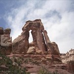
When I started the trail just below "Rock of Ages", my GPS said 700 feet to the cache and it took me an hour to get there.
Was the 700 feet an accurate distance (crow flies) when measured in BaseCamp? How long was the track between them, and did it correspond with the actual path you traveled? I just tried to make an accurate track of the Fisher Towers trail near Moab. All the multipath caused my trip computer to show 3.5 miles for a 2.1 mile trail, and the track was 100 yards off trail at several points. GPSr was Etrex30 with WAAS and GLONASS turned off.
-
Does the antenna on the GPSMAP 62 make it any better than the Oregon? I think that was my only concern with the Oregon.
Some folks make a big deal about the antenna, but I've never found a significant difference doing side by side comparisons with my 62s and OR300. Of course, with the 62s you can add an external antenna that you can wear in your hat. I've tried this too, but when I didn't have a clear view of the sky it didn't help.
-
Both are great units.
It really comes down to personal preference whether you prefer a touch screen or buttons. Personally I enter a whole lot of field notes (not from caching) so I much prefer the 450's touchscreen having come from a 60CSx, but you do have to live with not being able to view the touchscreen in 1 specific lighting condition as well as the 62... still viewable just not as well. (There are numerous threads discussing this)
62s will be much easier to read when mounted on a bike handle or other fixed location. No big difference if handheld.
-
I think some flat landers are missing my point. When you you hike up a mountain two things mess up a GPS, altitude change and switch backs. When I started the trail just below "Rock of Ages", my GPS said 700 feet to the cache and it took me an hour to get there. Also, the GPS tries to smooth zig-zags in a track caused by position errors and ends up smoothing out switch backs.
Multi-path, and visibility always mess up my tracks when hiking near the bottom of a cliff, but they usually lengthen the track, not shorten it. But if you are in the mountains and you lose signal, then reacquire it, you could get a straight line running from end to end of a curvy route.
-
How can I personalize my new 62 so that when it is tyurned on it shows the screen with my name and reward # on it?
Edit \Garmin\Startup.txt. It will be in the \Garmin folder in internal memory.
-
Just one note of caution - the fact anyone can change the maps means they need never be out of date, but also they are easier to vandalise.
You may also find the routing can be a bit - er - temperamental. I had major issues with routing using OSM maps, so tend to keep a close eye on the proposed routes. I still use them for cycling but wouldn't use them for driving, simply because on my bike if it tells me to do something silly I can get off the road, turn around anywhere I want, walk the "wrong" way along a one-way street, and other similar stuff I can't do in my car.
Well put. I use it on the trail, or maybe driving town to town in rural areas. I definitely would not use it to get me out of a bad neighborhood in an unfamiliar city. City Navigator, on the other hand, has done that for me several times. OSM provides an especially good to consolidate trail data, because it's hard to find large amounts of it on commercially available maps.
-
You bought one of the best gps'es ever build, but also with that model it took them about 2 years to get it in order and as I explained you in the other tread, you have the wrong gps for paperless geocaching.
If you are talking about geojakey, I don't think so. The 60CS performed poorly compared with the 60CSX.
-
Mapsource can detect the 60CSx without having the GPSr in removable drive mode.
Right you are. I just didn't wait long enough.
-
yes, I have an etrex 20. I'm in Lincoln, NE. Not sure what you mean by OS (operating system,= windows). I've been on open street but ends up in page not available. I have a log in and try to export but never works out. I've read SO many faq's, forums i'm's i'm pretty much blue in the face. I agree, I need to start to put "something" on my device and see what it looks like but I figure in this geocache forum I can cut thru some red tape.
To download maps from garmin.openstreetmap.nl you don't need to log in. To get data from OSM you may need to log in, but then you'd need to compile the map also.
-
You need to be in Mass Storage mode for MapSource to detect your memory card. You must NOT be in Mass Storage mode for the Web Updater to detect your 60csx. If you've been unable to get a connection either way, try a new cable or a new USB port. Using Win7-64 I was able to make both types of connection using MS 6.16.3 and Web Updater.
-
I think SGW has a similar topic. So I'm sorry if this seems like a repeat. But I don't understand maps. I've used my droid bionic to geocache and actually like it (alot). Shows ALL caches, I can zoom in, see details of the cache, and log. It pretty much does everything. But it drains my battery. When I geocache I might be all over the place. I thought an actual gps device might be better. So I have set up the PQ's and they are on my gps device (garmin etrex 20). But I am having major anxiety over maps. Free is good and if I pay that is fine if it shows what I want. Will I be able to see more than one cache at a time? Can I zoom in/out? Will I see the details of the track I want? Can anyone fill in some of these blanks?
Do you own an Etrex 20? If so, download some (maps with an installer) and a copy of BaseCamp, and see if they do what you want. You'll never know if they show what you want unless you look at them on a GPSr. Yes they zoom.
You don't say where you are, or what your OS is. If you did you might get more helpful answers.
garmin.openstreetmap.nl is a good place to start with free maps.
-
Wow. That's cool. Yes, trail information is there AND ROUTABLE. At least in the one little parcel of conservation land that I'm looking at. Again, for this one place, it appears that the trails on garmin.openstreetmap.nl are identical to what I see on www.openstreetmap.org.
Thanks! More maps more fun!
That's because they're made from the same data. Somebody hikes the trail, uploads to OSM, and makes it available to the whole world.
-
Atlas cached links to garmin.openstreetmap.nl . Those maps are much more up to date than 2006, probably within the last month, but all OSM data is added and maintained by volunteers. Those maps have routable roads and trails, but no contours. To get contours find a transparent contour overlay map that covers your area of interest.
-
My other question is, how much better is the 24K Topo map that Garmin is selling for close to $100.00? Has anyone compared the Gpsfiledepot free map to Garmin's 24K map that they have for sale?
Which map are you having a problem with? It might help if you posted a screenshot. It might help even more if you asked your question on the GPSfiledepot forum.
-
I've had fairly good success with support@garmin.com in the past, although their service department is mainly staffed by morons these days.
My experience too. Most detailed response I got was "Be sure you have the latest firmware."
-
If I had to complain the area would be on the maps - terrible - need better and cheaper maps so we can see good terrain, good roads and trails. Show me where I am.
Lots of free Garmin maps available. USA>GPSfiledepot, UK>Talkytoaster, EU>openfietsmap and opencyclemap. garmin.openstreetmap.nl has free routable maps of the whole world.
-
If you register with myGarmin, and ask a question there, and provide a serial number for your unit, you should expect an email in 3 days. They also have an 800 number you can dial in the US.
You might also get answers to your questions here. It would help to know which GPSr and which software you are having problems with. You might even get answers on this forum.
-
Splashy, you could be a little clearer about WHO's confusing.
-
This is the way to go.......I buy it on the SD card......just snap it in to your unit and you've got detail street maps nation wide and food, hotel, etc. locations at your fingertips.
The card can also be moved to another unit if you like.
You get to use it on multiple devices that way, but you need to swap the card if you ever want to use third party maps. Personally, I'd rather get it on disk, or with a lifetime update, install it on my computer, have it locked to a single device, and be able to add third party maps to it. For instance you can get transparent overlays that add topo or public lands boundaries, but you wouldn't want to put that on a proprietary card.
-
started my Oregon 450 after being off for a few months and found only 1/3 of the screen displaying.although the interactive screen seems to be functional. anybody have this problem and resolved the issue?
I've had the entire screen on my 60csx go illegible after I tried to rub something off it with a dry paper towel. Static electricity was messing it up. Try wiping the screen with a damp cloth. If that doesn't work, it's probably something bad as suggested above. As suggested by Atlas Cached a photo would help.
map62 and trackmaker
in GPS technology and devices
Posted · Edited by seldom_sn
Don't know anything about TrackMaker, but BaseCamp will draw an altitude profile of a loaded track. Select the track with the Arrow tool, right click to open it, and select the graph tab.