


jbuffethed
-
Posts
171 -
Joined
-
Last visited
Posts posted by jbuffethed
-
-
With Garmins you can create your own custom symbols. A long time ago I created a set to help me remember what marks I had searched for/found/not found, etc and after each benchmarking trip I modify the waypoints to show the appropriate symbol. I also use the Garmin categories in the same way so I can filter the various marks in Mapsource. If anyone wants the custom symbols I can send them to you. This was discussed a long time ago also, at Forum link. I can't recall if anyone asked for the images at that time.
Sure, Ill take them. jbuffethed at yahoo dot com
What is the process of getting them to the gps?
-
My Adjusted show as an Unfound gold treasure box. My Traditional caches show as a green treasure box, so I can decypher the two. I can post a screenshot when I get home. I meant to do it last night.
I dont think Garmin has a benchmark icon. I've been trying to figure out how to get one to show on the gps, but havent been able to.
Thank you for all your work on this program. It rocks!!
-
Download the .dat files from here: http://www.holoscenes.com/special/geocac/ds_archive.html
Convert the .dat to gpx with this program: http://ngs.tsqmadness.com/help/index.html
Just drag the gpx file into your Garmin/gpx folder. On my map (Colorado 300) Adjusted marks show as a gold treasure box and the Scaled show as a "?" just like a puzzle. It makes it much easier to decipher. You will also get the description like you would with your PQ.
-
Yeah, that's alright, but what about just the patch?
The logo patches are also available as a separate item – 2 3/4” are $3.00, and 3 5/8” (same as actual disk) are $4.00.
Seems to answer it right there.
-
I had the same problem with my 205W. Dragging th gpx pq into the gpx folder stopped working. It used to just show the icons on the map with no details, which is fine. I use a Colorado to actually locate the caches.
This fix I found was loading the pq into mapsource then sending to unit. I have tweeked it a little by loading into GSAK first and edit it to show the name and code of the cache. Then I load into mapsource and send. This way the name and code of the cache show on the map.
-
-
You gotta think about cover as well. If you get into some thick trees, you are going to get a better signal with a handheld than with a cell. I also have a DX, but use my Colorado primarily.
-
II took a picture but for some reason am unable to upload it to this site.?

Thanks
Try resizing the photo. I had the same problem and hsd to shrink the pic. After that, it worked.
-
If you were close to Sterling OH, then the benchmark is almost certainly PID KY1726. Just log it.
This is how marks are mis-logged. Peope are out caching, find one near the cache, click to find the closest mark and log it. Make sure your designation matches. If your mark is in the GC database, it could be either scaled or adjusted as well. You cant just log the first thing you see. If you find out it is not in the GC database, just make a Waymark. I did that with 2 on my recent trip to Gatlingburg.
-
The first time I saw the Microsoft tag I was out with a friend who had a smart phone. He said he already solved it. I just kept staring at the image wondering how the heck he got coords out of it. Now that I have a Droid, its a piece of cake.
-
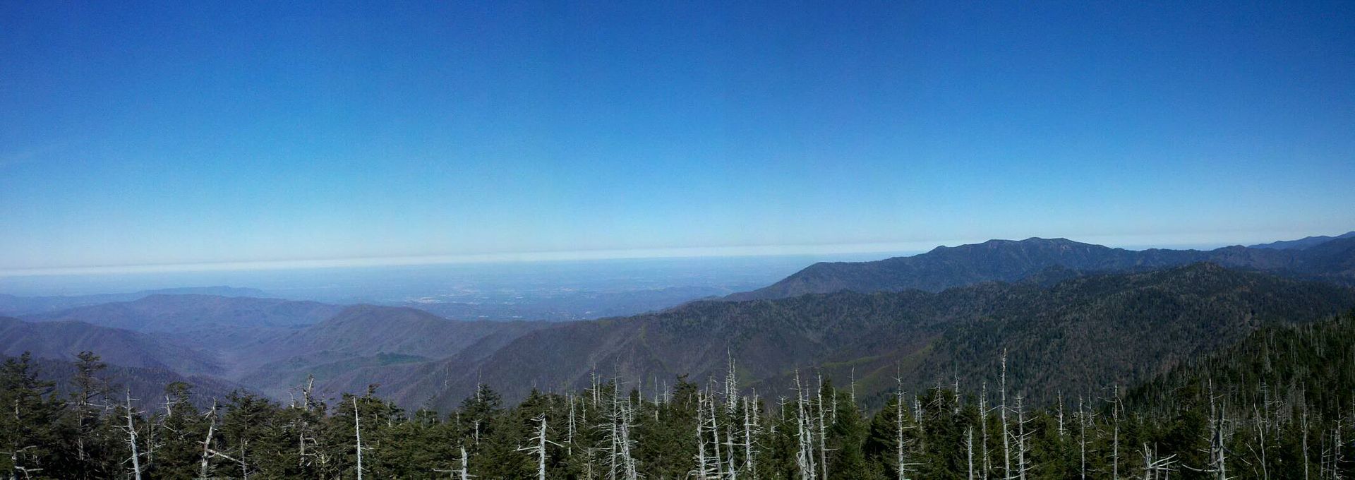
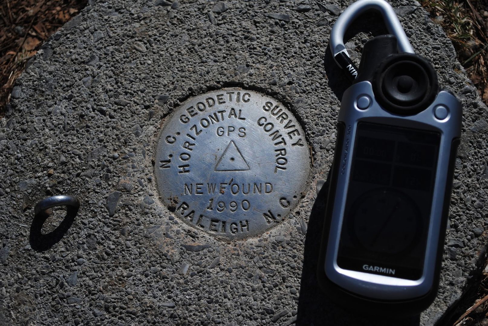
I was recently up in Gatlinburg on vacation. We hiked out to a virtual Porter's Creek Trail Virtual.
Its an old farm site with a barn and a cabin. In between the structures is a small trail. At the trail head from the barn to the cabin I found a mark atop a rock. I have in a few places that I know to look and could not find anything.
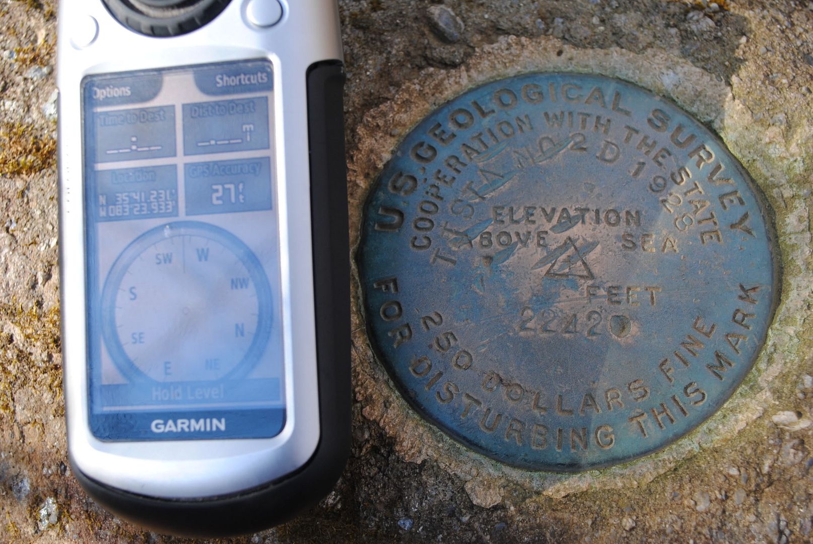
It looks to read TT STA NO 2D 1928.
Coordinates: N 35 41.231 W 083 23.933
I have already created an waymark for it. Can any of you find anymore info on it?

-
I just had the same thing happen on my trip up to the Smoky Mountain's. I did a Virtual and was walking between historic buildings and stumbled on a benchmark atop a rock. Not in the database. I am going to create a waymark when I get home.
-
I just tried to upload another photo and it failed again with the the same error message.
I think there are others having the same issues.
I have another find to log but not until these issues are resolved.
Have you tried a different browser? I found one the other day and uploaded 3 without a problem.
-
I bought my 300 almost 2yrs ago for $249 from Costco. It has been awesome for paperless caching. I have recently started hunting benchmarks and wanted that paperless as well. I found an awesome program that converts the .dat files to gpx.
-
http://www8.garmin.com/support/download_details.jsp?id=3887
Change History
Changes made from version 3.40 to 3.50:
* Added brightness adjustments for BirdsEye imagery. (On the map, press options, Select Map, BirdsEye Satellite Imagery)
* Increased the map drawing range to allow maps to draw farther south.
* Fixed map display problems.
* Fixed improperly cropped review text.
-
I have a 205W that I use for the driving portion of the cache. I am a premium member as well, so setting it up the way I do might vary.
#1 The only way I can get the caches to show on my screen is loading the gpx file to Mapsource or GSAK, then sending it to the unit. Dragging and dropping doesnt work like my Colorado. If you download just the .loc I assume you would use the same process.
#2 If you are a premium member and can get the PQ's, then you can use GSAK and download the garmin-nuvi-exportgpx.gsk. As long as you have the Garmin POI loader installed it will automatically send the new gpx file to your gps as a poi with all the info.
Tutorial on the POI process.
http://geocaching.totaltechworld.com/
I use #1 just to get the caches to show on the map and #2 to get all the cache details. You would normally have to zoom in real close to see the POI's.
-
Is it possibly this. Looks like this guy possibly found the same one, but he found 01 92 A24 .
-
Thank you for all of the input. Even though I work on base, I didnt want to stand out too much walking up and down in between two old hangers that are occupied. I will definitely go back and see if I missed anything.
-
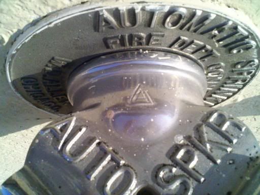
I had some spare time today on base here. Maxwell AFB, AL 4 Scaled benchmarks. I was looking at the following benchmark: CN0617
I found the two hangers listed in the description and found a fire plug. The plug had a triangle on it like a disc would, but instead of having the drill hole, it looked to have another smaller triangle inside it. I also did not see any numbers or anything. I had never seen one before and wanted to confirm before I marked as found. I attached a picture that will hopefully help.
Thanks
-
Extract file or drag/drop into Garmin/GPX
-
A friend and I set out to do the power trail just west of Lake Ponchartrain in Lousiana. Not something to bring the kids on. Its 120 or so caches. We only did about 20 because it started to down pour and the kids got antsy.
-
I get my Droid X today. Im going to try geobeagle first. I doubt it will replace my Colorado, but its worth a shot.
-
I helped with the one in Minot, ND when I was stationed there. Even got the T-shirt.
-
I have the same problem with my 205W. Dragging and dropping does not work like it does with my Colorado. I either open the gpx file in GSAK or Mapsource and send them that way. Its the only way Ive got it to work.
With GSAK I run the macro for the Nuvi to convert to poi and give you all the data. Problem I have is the caches wont show on my map. So I end up loading the poi converted in GSAK along with the plane old gpx through Mapsource. Those will make the caches show on my map.

Benchmarking
in Benchmarking
Posted
I have completed all the local puzzles, so all the "?" are Scaled marks. The Gold boxes are Adjusted marks. The Green is a traditional cache. The icon where the arrow is pointing is a mast or tower. That one in particular is a microwave tower. If I could get your icons onto my Garmin, I wonder how or if they would change. I dont even have a clue how to load them except sending from Mapsource. Mapsource will not recognize the converted gpx file either, so thats where I am stuck.