


the pooks
-
Posts
904 -
Joined
-
Last visited
Posts posted by the pooks
-
-
Would anyone know where this is? Almost looks as if it can be FollowThatRainbow sticking his nose out the window.
https://www.youtube-nocookie.com/embed/skC8u4Ok0Kg?rel=0
OK - found out where the road is
http://www.dangerousroads.org/asia/india/3360-kishtwar-kailash-road.html
-
ceolocanth? (sp?)
-
I was in Pilgrims Rest years ago, but I seem to recall there was a mining side to it (no doubt!). Is there not a cableway that was used to transport mining material off the mountain?
-
Have been focusing my eyeball on Simonsberg and have come to the conclusion that if there is cloud about, it sits on that mountain. According to the weather guru Sat seems a little risky cloud-wise, so we are going for Sunday 19 January 06h00. Have quite a few customers already. Bring water. My cell 0827663807
-
There are a bunch of new caches on Simonsberg near Stellenbosch begging for an expedition. I had let out feelers indicating my intentions to join such a party and now it seems the onus is on me to do something. Terunkie and CnC invited me on a very impromptu assault last Saturday but we were refused access by an adamant security official as the mountain was under cloud (from his angle) and he has strict instructions to forbid access to the hike under those conditions. The hike is therefore subject to the whims of the weather (not an entirely bad idea, although it would have been a beautifully cool day)
I will be doing some more subterranean research (evaluating existing interest and the weather) and post a date closer to the time. Anyone with ideas is welcome.
I was going to start the ball rolling by proposing next Saturday, but from the 7 day forcast there might once again be cloud about = risky

-
Was going to say Kimberley, but Westonaria sounded much more informed, but now I will say Kimberley anyway - just to add to the mix.
-
Hike to Penny's Cave with meridian hiking club and geocachers
Photo's
https://plus.google.com/photos/105115185718724242948/albums/5952292789002242401?banner=pwa
More photos on Meridian FB page
https://www.facebook.com/groups/5472975993/
Some background info on the cave with link to resources for more reading
http://www.geocaching.com/geocache/GC459D3_pennys-cave?guid=477f25a2-5d15-409f-9084-21b21d3ebc12
another interesting link (very thorough research into the whole Joshua Penny story)
-
Re Penny's Cave
saturday 30 Nov 8am, Theresa Ave. Quite a long hike (4-6 hrs). Bring enough water and food. My cell no 0827663807
-
Full Moon from Lion's Head : 360degree
CLICK ON AND DRAG MOUSE UP AND DOWN AND SIDE TO SIDE SLOWLY.
-
Leading a hike for Meridian Hiking Club to Penny's Cave 20131130 (weather permitting). Time to be arranged. If interested let me know.
-
Mount Nelson, 2 flights
Wild guess there!

Where was the first elevator [lift] installed for public use in South Africa? For a bonus - how many flights did it go?
-
Caching overseas is bad news for personal relationships. You spend ages getting a sim card, downloading pocket queries, figuring out how to get it onto your GPSr, worrying about battery life and at the end of the day you forget to look at the flowers and whisper sweet nothings in a beloved's ear (or in the case of a beloved not available, anybody's ear). If you are going to be in specific areas then probably worth downloading a couple of PQ from home - that is where the dedicated GPSr comes in handy - cache data saved without having to connect to the airwaves. My ideal solution would be a smartphone with extra battery backup (there must be a way to use ordinary batteries with an adapter - newer smartphones have micro USB), or even a portable solar panel - think how exotic that will look. Best is to do what you have done - sniff around and pick a few to focus on, and try very hard to ignore the rest. I bought my Oregon 300 for R2000 2nd hand - not great in sunlight, but I like the fact that it uses standard AA batteries. I bought a camera that uses the same batteries, so can interchange or use non-rechargeables in a squeeze - that to me is one of the bigger plusses of the Oregon. Hardly ever use the camera though as smartphone can do most for the everyday photos one takes most of the time.
I got a gadget from a certain local Cape Town doctor (well known in geocaching circles) that must have come from a rep - you stick in one AA in the holder and on the other end are various adapters for all sorts of devices and voltages. Haven't used it though, for all I know it might be a chinese fake...
-
Big Ben?
-
OK - closer curves. The underwire bra? The testicle? (not sure how he could be involved in that...) Bloukrans bridge?
-
The man (Giles Gilbert Scott) who designed Waterloo Bridge was responsible for another iconic design that shared the identical curvature as those of the bridges arches.
What was it?
this is ineteresting but obscure. Firth of Forth is the only one I can guess at this stage (also has lovely curves/curvature)
-
Isn't it one of those poor sods who has had his tubes tied so when he tries his luck the bell rings to remind the farmer or ram (who has real goonies) to step in, so to speak?
PS: If anyone wishes to misinterpret this explanation, you do it at your own risk. This is information based on fact!
-
Sorry folks. Not getting around to a question. mind has struck a blank. anyone jump in please. I'll be better prepared next time.
-
lindbergh?
-
Nope...
high performance?
-
-
This looks like the work of daniel Dobinson of irideafrica. I looked into the mapping scene a bit and did not have much success. These sorts of maps are generated by the likes of ArcGIS which is pretty expensive commercial mapping software. I pottered around with some freely available software, but it was frustrating and not successful. You can get all the raw map data from Surveys and mapping in Mowbray. Take along your portable hard drive and they download it for you. But the data is in the form of shape files (shp) http://en.wikipedia.org/wiki/Shapefile and needs to be processed by the said software above. At a stage I generated custom maps for the Explorist 500, but that was quite a learning curve. I would love to share ideas and be able to generate 3-D maps such as that above, so if you get anywhere let me in please.
-
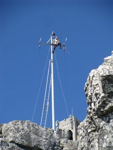
When I accompanied Dbob in placing this cache there was this bloke sitting at the top of the pole doing maintenance. hectic
-
capedoc, I think you are being inflammatory, demeaning and judgemental
-
Which android geocaching app
in South Africa
Posted
I finally succumbed to the will of the masses and migrated from Nokia to Samsung. Not because I did not like the Nokia, but more because it was stolen and Nokia seems to be in a state of flux finding its feet. The low end nokia smartphones don't have a LED flashlight, which is one of the things I find useful (besides making phone calls). I used to have GC Live on the Nokia, but googling android geocaching apps returns a very intimidating array of apps. So what do the geeks out there recommend?