


Triple Crown
-
Posts
520 -
Joined
-
Last visited
Posts posted by Triple Crown
-
-
There might be a way to upload your finds from the 60Csx to GSAK and then log from there, but I'm not sure about that. Might want to check on the GSAK forums.
-
Everytime I get back from Caching, I have to manually put in the finds I made to Geocaching.com. Am I missing something-shouldn't it automatically synch when I plug the unit into the computer? I upload or write the caches fine onto the GPS from geocaching.com.
New to this so I need some help.
douger67
The 60CSx doesn't support field notes, which can be uploaded to GC.com. The newer paperless units do.
-
Eastern Mountain Sports has the Montana 600 on sale for $400. Lowest price I've seen.
-
I cache with a 60CSx that I've used so much that the lettering has worn off of most of the buttons, but I do NOT consider moving to a newer GPS to be an upgrade. I dearly love my 60, and when it dies, it will be a sad day. I had a Colorado for about a month when they first came out. I hated it. I brought it back to REI and traded it for the 60 and haven't looked back.
If you love the 60CSx then you should definitely try the 62S...it adds the paperless caching experience to your familiar friend. The DeLorme will get you more bang for your buck, but in my experience, the Garmin user interface is easier to use.
I really dislike the Colorado but like the Oregon, but I'm hoping to upgrade from my Oregon 300 to a Montana 600 soon. It's worth a trip to REI (or other retailer that has working displays) to try them out in person and see what you like.
-
I would like to share an experience with you all, about drinking and driving. As you well know, some of us have been known to have had brushes with the authorities on our way home from the odd social session over the years. A couple of nights ago, I was out for a few drinks with some friends and had a few too many margaritas. Knowing full well that I may have been slightly over the limit, I did something I've never done before -- I took a bus home. I arrived home safely and without incident, which was a real surprise, as I have never driven a bus before and I am not sure where I got it from...
LOL! Nice work!

-
We are learning to use pocket queries and our new Oregon 450 tonight. We figured out how to download the caches onto the Garmin, however, the caches we've already found don't show that status. We like seeing a smiling face or open treasure chest.
Is it possible to make this happen?
Thank you!
Paula
Yes it is. I recommend using GSAK. There is a macro called Garmin Export that will send all your found and/or hidden caches as POI's so they don't count against your 5000 cache limit. You still see the smiley or star on the map though.
-
For the Garmin 62s, the Garmin 24k Topos also include the routable street maps, so if you're only using your GPSr in the areas covered by that map, it's probably the way to go. If you want road maps for the whole country, you'll want either the City Navigator (easier) or the free openstreetmaps (cheaper) The BirdsEye subscription will allow you to download aerial imagery, which is nice, but for me, not a necessity.
With the DeLorme, the subscription will get you aerial imagery (like Garmin's separate BirdsEye product) in addition to maps of the whole country, so things like ponds will be visible there even if they're missing on the topos.
I think you probably get more bang for the buck with the DeLorme units, but for me I prefer the Garmin user interface as it seems more intuitive to me.(Though I prefer the touchscreen units)
I don't think the maps will be the difference, I think your preference of the day-to-day ease of use of each unit should guide your final choice.
-
Those of you with the Oregon how do you find readability in sun/bright light etc?
And how do you find battery life? Anything close to the quoted 16 hours with rechargeable?
The Oregons have a very readable screen, tilting the screen slightly makes it readable in any lighting condition. I usually get closer to 8 hours out of a set of rechargables, but I set my screen to always on since I find the backlight timeout to be annoying.
The eTrex screen is a bit easier to read in direct sunlight, but the tradeoff is lower resolution and for me the screen is just too small.
I would really recommend going to REI or some other B&M retailer so you can see the units side-by-side and play with them. I find the Oregon touch screen easy to use while the eTrex joystick a bit clunky.
-
Thanks for the heads up. GPS City (Canada) had many items on sale for Black Friday and Zagg screen protectors where one of them. I have an Oregon 450 and was seriously considering ordering that product but I've never been comfortable with the idea of applying an additional layer to the screen. Granted, I'm not locating 100 plus caches a day nor am I constantly tapping the screen while hiking or trailblazing. In my opinion, for casual use the screen is durable enough. I think I'll make more of an effort to keep my fingers clean.
The Zagg works great on the smaller screens like the 450, it becomes a problem on the much larger screen of the Montana when you try to remove it. The Zagg has saved my 300 screen more times than I can count from drops or when I fall with it clipped to my belt...well worth it for any of the regular sized units!
-
Are topo's even locked? The DVD based topo's I have are not locked, can't see why the SD version would be.
The Topo's are not locked since it's not proprietary data, but the SD card maps cannot be downloaded to your computer for viewing in MapSource.
-
The lithium batteries last longer, but the voltage drop-off when they die is abrupt so you get almost no warning...they just suddenly die. The battery meters have voltage dependent profiles for alkaline or traditional rechargables only.
-
Thanks for the heads up! Hoping for some Montana price relief...
-
For me, the eTrex screens are just too small, and the menus are cumbersome to navigate. I also find it difficult to read all the paperless caching info on such a small screen. I had a 60Csx, but I like the Oregon touchscreen interface much better. I would recommend going to REI or some other retailer that has display units you can power on and try. I currently have the Oregon 300 but I think my next unit will be the Montana 600.
-
I would also recommend not getting the 'T' models. The 1:100K topos they include give you contours about every 100' which is not very good for hiking. You can download FREE 1:24K topos from GPSFileDepot which have contours that are 20' apart.
Also consider the Montana 600 if you don't need the camera. For any of the Garmins you can get free routable street maps at OpenStreetMaps.org but I prefer the Garmin City Navigator product.
I previously had a 60Csx and currently use the Oregon 300. For me, the bigger screen and touchscreen interface make the Montana my choice...hoping to pick one up soon.
-
Don't have the MAC Basecamp but if it works the same as the PC one you right click the All Data folder of your device, then click on install maps and follow the Map Install wizard.
I can't see the All Data folder of my device in BaseCamp.
Also I don't see anything on my 450 screen when it's plugged in to the Mac except the Garmin name and the picture of the GPS plugged into a computer. I don't know if this is relevant but I can't turn on the 450 when it's plugged into the MAC. I am lost!
Cache on the spot
When you plug the Oregon into the computer it should ask you if you want to go into Mass Storage. If it doesn't then the computer won't see the unit. Make sure you go to Settings/System/Interface and select Garmin Spanner. Hope that fixes the problem.
-
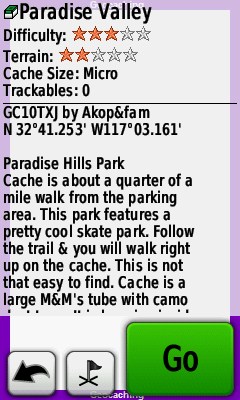
What enhancements? The top screenshot is the normal display you get on any Garmin handheld paperless GPS introduced since the Colorado. The macro only enlarges the text as shown in the lower screenshot.
Here is a screenshot of the macro control panel. I use the macro to send all my hides & finds as POI's, also I get the last 15 logs on each cache. The macro just gives you a lot of flexibility with what to send to the GPSr.
The proximity alarms are cool in areas without a lot of caches, but not so much in areas that are cache saturated, so I don't use them.
-
Welcome to the club. I still get buy with cheap dime-store reading glasses, and unless I'm in bright sun, I have to wear them to cache now. I've even found that when searching for some nasty micro in the shade of deep woods, I'm using them to search, not just use the GPS! Trust me, it doesn't get any betterRecently I bought a Magellan Explorist GC, because I wanted to go paperless, and it was the least expensive option. Been out a few times with it, and I'm not happy with it. My aging eyes need larger, brighter font, and the Explorist GC doesn't cut it. Any ideas? How is the font size on the new Garmin eTrex 10 GPS, and do I "have" to use Opencaching.com for my downloads, or can I still use Geocaching.com? HELP!!!

I looked at a number of units the last time I bought a GPS, and it's no piece of cake with any of them. Many with larger screens just pack more on the screen with the same icon/feature/font size, and that doesn't help at all to solve this particular problem.
For more recent Garmin units, the font size can be adjusted. Setup / Map / Advanced Map Setup / Text Size. Size is separately adjustable for several categories of items.
Does this change the font size on the geocache description pages or just on the map screens? The only way I've been able to change the font size on the cache descriptions is with a GSAK macro. I've been using the GarminExport.gsk which has a checkbox for 'use large font' when it sends the caches to the unit. For comparison here is the screenshot from a cache page sent directly to the GPS vs the same cache page sent using the GSAK macro set to Large Font
-
owner number?
On your profile page, select 'account details' and your member ID will be below your username.
-
With my eTrex Venture HC I could take the custom portion of the waypoint symbols and edit them to something I liked. For example I had a different style open treasure chest for my caches, and another style open treasure chest for my partner's caches. Using those custom symbols meant they would never get deleted when I deleted all geocaches by the normal geocache symbol.
Now with the 20 I'd like to load those symbols into the waypoint icon table and use them again but I don't see a way to do that.
Anybody got any ideas??
There is a GSAK macro that will allow you to load custom symbols. I used when I had my 60CSx. You should be able to edit the symbols in Paint or other similar programs.
-
This Just In...
Honk if you know where this peice of luggage has been...
Honk! Honk!

-
I have noticed the past few cache outings with a buddy of mine we can't share files wirelessly anymore. The units just keep searching but won't connect. I'm using a 300 he's using a 400t. We always manage to get out his query area or he's just keeping them up to date. Probably more the area. We used to be able to share files in the car and as far as 20+ ft away. We both have our units software up to date. I believe we must have lost the ability in Version 4.10 or one of the following betas. Anyone else notice this or have a cure for it.
Thank You
I have noticed that if one unit has weak batteries it usually won't connect.
-
Still looking for a little help, here.
The authentication file has a .gma extension I believe it is generated by MapSource and transferred along with the map. If you call Garmin Tech support, they can email you a new .gma file in case yours is corrupted...guess how I know this...

-
I recommend you get the City Nav. maps from Garmin on the micro SD card. Works great on my 450, snap it in and you're good to go. I got the City Nav software for my 60 CSx but I like the card approach better....you can also move the card to another unit if you like.
The City Navigator on microSD IS easy to use and portable, however it can't be updated and you can only look at the maps on your computer while the GPSr is plugged in to it, also you can't add maps to the card so any other maps you want to install will need to fit on the units internal memory. For ease of use the microSD card is the way to go, for maximum flexibility, the DVD version is better, but it is also locked to just one GPSr.
-
Just got an Oregon 450 at the Labor Day sale at REI - love saving that kind of cash! But, the pre-loaded map only shows freeways and major highways. I'd like a street map, like the one I have on my Nuvi, on my Oregon. I've seen references to downloading free maps using Base Camp or MapSource, but the process sounds quite complicated and I'm afraid of screwing something up. But I've heard the Garmin maps you buy aren't that great either... Any suggestions?
You can get lots of free topo & trail maps at GPS File Depot and free routable street maps at Open Street Maps just be aware that the Oregon has no voice capability, so you just get beeps when it's time to turn.
The Garmin City Navigator NT product is super easy to use, and the price has dropped recently so you can get it pretty cheap.

Mapsource?
in GPS technology and devices
Posted
Yes, turn by turn, but the 60Csx has no voice, just beeps for each turn (plus text).