


Triple Crown
-
Posts
520 -
Joined
-
Last visited
Posts posted by Triple Crown
-
-
Are you kidding me? Garmin's new units actually incorporate their lame-o OC rating system into the UI of the device? 👎
If I'm not mistaken, they are pre-loading new units with their own caches, too. However, that one is easy to fix and delete.
My new Oregon 650 was not preloaded with OpenCaches.
The extra option doesn't impact any other functions. So it's kind of a First World Problem. 650 Filter
-
I'm trying to find a convenient way to sort and/or filter my finds by cache name. This seems to be such a basic thing and I can't understand why it doesn't seem possible! When you have 100s or even 1000s of finds, cut and pasting from the website into an excel spreadsheet is just a waste of time. Please make this an option on the website. It is essential to be able to sort and filter by cache name when attempting to complete many challenges.
Thank you,
tumbleweed42
You should look into GSAK. It's a really powerful tool for cache database management. (also free) http://www.gsak.net/
-
Thanks for all your answers

I´ve bought it and i must say: it´s very good. I only got one problem: the shopman told me, i could do paperless caching even though i am not a premium member. But it doesnt work
 can you help me??
What doesn't work?
Paperless cache files can be either GPX or GGZ. LOC files contain only coordinates.
-
It's a pretty good unit, a bit more battery hungry than the 450/550, but the display is brighter. The display is also far more sensitive to touch for navigating screen/menus, which can be a bit vexing when you look at it to find it's busily resetting things on you from contact with various objects.
Get a screen protector for it, I don't care what anyone tells you about the glass, it DOES scratch. I've got two scratches in mine already. Screen protectors are a small price to pay and don't affect display sensitivity or view ability to any significant degree.
+1
I installed a screen protector on day 1. This screen is much tougher than the older models, but the screen protector (ArmorSuit) is cheap insurance and feels like glass.
I upgraded from the 300 to the 650 and it's a great leap forward. The screen is bright & works like a cellphone screen. The GGZ file type means you don't have to delete/reboot/reload when adding files. Also the 650 comes with the rechargeable battery pack, which seems to work pretty well so far, and the camera has been quite handy, which surprised me.
-
I'm looking at the Montana 600 and Oregon 600. Functionally they seem similar; the main differences I see is the Montana has a larger screen (but is bigger/heavier), and the Oregon supports GLONASS. I think the choice between the two will come down to how I feel about carrying them and the screen size.
Ok... so here is my dumb question. With my Legend HCx, the only way I know of to install maps is to copy a file with a specific name (gmapsupp.img). At least as far as I know I can only have one map "active" at a time. (I can store more maps on the SD card, but only the one named gmapsupp.img is active).
I find the manuals of the Montana and Oregon a bit confusing, but it appears they support multiple maps at the same time. This is what I would like to understand better. I.e - could I use a map optimized for road routing to get to the parking location, then switch to a topo map to hike to the cache, and how easy is this to do?
The other example would be when I'm travelling. Today I have a map I use while in the UK. If I go to mainland Europe I have a different map. I have to connect the GPS to the PC and fiddle around with filenames to change the map. With the Montana/Oregon, would it automatically choose the appropriate map? Or would I need to specify (and again how easy is this?).
I guess what it comes down to is I'm looking for reasons to convince myself I really "need" this...
I looked at the Montana but decided it was too big for my taste, so I went with the Oregon 650.
The screen is great and the touch interface is very similar to a cellphone. Also the rechargeable battery pack charges in the unit, so you can charge while using it in the car if you want.
The Montana will hold 12000 caches, but the Oregon 6XX series will hold an almost unlimited number (Millions!) and the new GGZ file type is really slick.
With both units you can have as many maps as you want and you can have multiple profiles...for example the Automotive profile is set to on-road routing using my City Navigator maps, while the Geocaching profile is set to direct routing using both topo maps and street maps. Changing profiles is 2 taps.
With all of the newer units you can name the maps whatever you want, they still keep the .img extension. Also, you can turn individual maps on or off whenever you want.
My setup has the City Navigator North America installed on the unit, then my topos, Europe and Brazil street maps on the microSD card, so I always have maps for wherever I am.
Also, with the Oregon, you have 2 buttons which are user configurable to do whatever you want with 1 press, double press, or press & hold....and you can have different preferences with each profile if you want.
There is a lot of info available at the Oregon 6xx Wiki, so you should check that out too. In my opinion, the Oregon 600 is a great leap forward for geocaching functionality.
-
I just had a similar experience. I ran 5 PQs, I got 5 emails, but only 3 of the PQs showed up on the download page.
My PQ finally showed up....for a few minutes...but when I went to download it, it was gone again. Weird.
-
I'm having the same problem. Got the email saying my PQ was ready, it shows that it was run, but it is not on the Pocket Queries Ready for Download list.
Following the email link just brings me to the PQ page.
-
The GGZ file doesn't suffer this problem, since the index is inside the file.
Too bad they haven't added GGZ support to the GPSMAP 62 family.
I did not know that. Thanks!
-
FWIW, I just upgraded from the Oregon 300 to the Oregon 650, and so far I haven't seen this problem (on the new unit) Also really liking being able to keep tons of caches available. (So far I've been using the GGZ file format because they're supposed to index faster for searching)
-
Another thing to consider is the temperature. Rechargeable batteries don't do well in the cold, and -8C is pretty cold.
-
Just an FYI - on either units (450 or 62s)
From what I understand - You can not use the SD card slot to 'double up' on the data.
In other words.....Once you stick an SD card slot in the unit, it will only LOOK at the data in the SD card. It will not utilize the data in the memory and the SD card data at the same time.
For instance - you're traveling. You load the GPS with data for one area that you are visiting. Carry an SD card with you that's loaded with completely different data for a different location that you are traveling.
This is not correct. you can have both maps and GPX files on both the internal memory and the microSD card and the unit will see both.
On my Oregon 300, the internal memory is very limited (<1GB) the base maps and any beamed caches are stored on the internal memory, but I keep all of the maps I've installed and my downloaded GPX files on the microSD card (about 6GB for City Navigator North America, plus several European countries & Brazil)
I recently upgraded to the new Oregon 650, and in my opinion, it's a great leap forward. The touchscreen is like a smartphone and it is much brighter than any other GPS unit I have seen.
-
Cabela's had the Garmin Oregon 450 on sale for $150, but they sold out. Now they have the Oregon 550T for $230 at Cabela's
-
Is there any way to delete POI information on the Garmin Topo Canada maps before or after loading them onto my Colorado? Looking roads in some towns it's hard to read street names because there are so many POIs cluttering everything up...not to mention, I could use the extra space. Ever since I updated my maps, my gps won't let me create a new waypoint, says there is no room let so any multi-cache is out of question since I can't input new coords.
I don't think you can delete the POI's but you can reduce the clutter factor. Disclaimer: this is based on an Oregon, but I think it will work the same.
Go to Setup, then Maps, then Zoom levels and change the zoom level of map points to either off or something small like 20 ft so they won't show until you zoom in really close.
The waypoints are stored separately from POI's, but you can clear out your waypoint memory by going to Setup, Reset, Delete All Waypoints.
-
.ggz files sound like another garmin proprietary thing. Probably has some opencaching tie-in.
Pretty slick looking unit though!
Just bought the Oregon 650T thought it held unlimited Geocaches, well it does as long as the caches are on OpenCaching and not Geocaching according to Garmin, 12,000 same as my Montana on Geocaching.com thinking of returning it.
Scubasonic
The smart guys over at GSAK updated their macros so you can send caches as either gpx OR ggz files...allowing you to have almost unlimited caches. It's worth looking into...
-
You can't disable a GPX in the field, but you CAN set a filter in the field...for example only show traditionals with a terrain rating of 1.5 or less.
Select Geocache, then Quick filter and set the parameters for your filter, then press the Search button at the top.
-
Hi,
I'm new to paperless. I can send a cache from the website to my GPS. Once logged, on my GPS, as found (or not) can I then send the info back to my account on Geocaching.com or do I have to load it manually. I have a Garmin 62S. Thanks.
If you're a GSAK user, you can also upload your finds using GSAK. It's great for power trails...like logging 1000 caches in 15 minutes or so.
-
Hello! I have several caches hidden, and one of them is apparently rather difficult. It is still there, but lately people have been logging it as DNF, and now nobody looks. What's the word on logging your own caches as "Found It" occasionally, if its still there but hasn't been found in a while?
A better alternative (IMHO) is to post a note or an owner maintenance log to let cachers know that it's still there. Another option is to email the cachers who logged the DNF and offer a hint so they can return to claim the find. It seems kinda silly to log a find on your own cache.
-
this model is already avilable in shops, just yesterday I had 650 in my hand at the store and its great, I'm seriusly thinking to buy 600 its have all I need for GC
)highly doubt it. No online store (including garmin) has it in stock and several sources are pointing to april launch.
also there is already another thread about Oregon 6xx series on here
Not available in the US yet, but apparently it's been out in Europe for a couple of weeks. (No FCC certification requirement)
-
We did recently load a bunch of caches in preparation for a trip we'll be taking soon, but I then took the time to erase several old finds. It does make me wonder, though, if we're near whatever the limit is.
I think the limit is 5000 caches or 200 GPX files, whichever comes first. You should delete old GPX files to avoid this problem.
-
Ok, what is an "OSM" map? Will the Garmin City Navigator maps be sufficient? I DO want spoken directions with street names.
I currently own a Etrex Legend Cx I use for geocaching and a Nuvi 1300 without lifetime maps. I am just wanting a device I can use for both geocaching and road trip vacations.
I saw a video on YouTube that showed the different "modes" the Montana 600 has, and in automotive mode it looks just like the Nuvi interface.
OpenStreetMap is the wiki link for the Garmin formatted free, routable maps. I use them for when I travel, I just download whatever country I plan to be in. Works well.
-
What is a good choice for free maps for say a Etrex 20 etc?
They've come a long way with the free maps and are very good quality these days.
Also check out Open Street Maps for worldwide free routable maps for Garmin units.
-
I'd also like to know a bit about the construction, particulary the face of the screen. My Oregon 450 is very scratched up, mended with a bit of buffing, but the damage largely happens as we get grit on our fingers while caching and soft plastic is no match for it. I haven't been able to determine from Garmin's publicity material whether this is going to be another plastic screen or something more akin to glass.
I recommend putting a Zagg Invisible Shield or equivalent on the screen on day 1, it takes the damage and is easily replaced.
-
I'm not familiar with the particular maps you've chosen, but there are a few pitfalls.
Make sure the maps are enabled in the profile you're using. Also, 1:100K topos only have a contour for every 100', so there might only be 4 contour lines in Florida. You'll want to get 1:24K topos for more detail.
Continue asking questions, we're a friendly bunch!
-
Since you've already got City Navigator, you're pretty much set for street maps, and that makes your purchase a great deal! Making a backup copy of the maps on your microSD card is also a great idea.
One thing to consider when adding maps is to remove the microSD card from the unit before transferring large files. File transfer to the GPS directly is really slow, but using an SD card adapter makes it much faster. There is an XML file on your GPS in the Garmin folder called GarminDevice which identifies your serial number and is what the City Navigator map is locked to. I copy this file onto the microSD card so the MapSource or BaseCamp program thinks your microSD card IS the GPS, which makes transferring files easier.
Also, if you don't already have one, a Zagg Invisible Shield or equivalent screen protector is a great way to keep your screen in perfect shape.
Wow, great information, thank you very much for sharing these tips. Can you elaborate a bit on how to copy the XML file from the GPS on the SD card? I'm not seeing the XML file in the GPS for some reason? (not sure really how to find it actually)
Oh yes, by the way, that little compass I was referencing earlier is actually in the upper left hand corner, OOOPS. LOL
To find the GarminDevice file, connect your Oregon to the computer, then navigate to Computer, then Garmin Oregon (in my case it shows up as drive E), then open the Garmin folder.
Here is the visual aid...

Then select the GarminDevice file and right click, select copy, then navigate to your MicroSD card (in my case it is drive F), open the Garmin folder, and then right click to Paste the file there.
 can you help me??
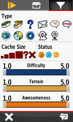
Can't download GCs using Windows 8
in GPS technology and devices
Posted
Also, there is a problem with Internet Explorer 11. It's a great browser for downloading Firefox or Chrome.
To fix IE11 go to Tools, then Compatibility View Settings and add GC.com to the list of websites.